| Research article |
|


|
|
|
| Unmanned aerial vehicle-assisted evaluation of the effectiveness of sand control engineering along a Gobi desert highway in Ejin Banner, northern China |
MA Xixi1, XIAO Jianhua2,*( ), YAO Zhengyi2, HONG Xuefeng3, XUE Xian2,4 ), YAO Zhengyi2, HONG Xuefeng3, XUE Xian2,4 |
1Department of Geography, Fuyang Normal University, Fuyang 236037, China
2State Key Laboratory of Ecological Safety and Sustainable Development in Arid Lands, Northwest Institute of Eco-Environment and Resources, Chinese Academy of Sciences, Lanzhou 730000, China
3Transportation Development Center of Alxa League, Banyanhot 750306, China
4Drylands Salinization Research Station, Northwest Institute of Eco-Environment and Resources, Chinese Academy of Sciences, Minqin 733300, China |
|
|
|
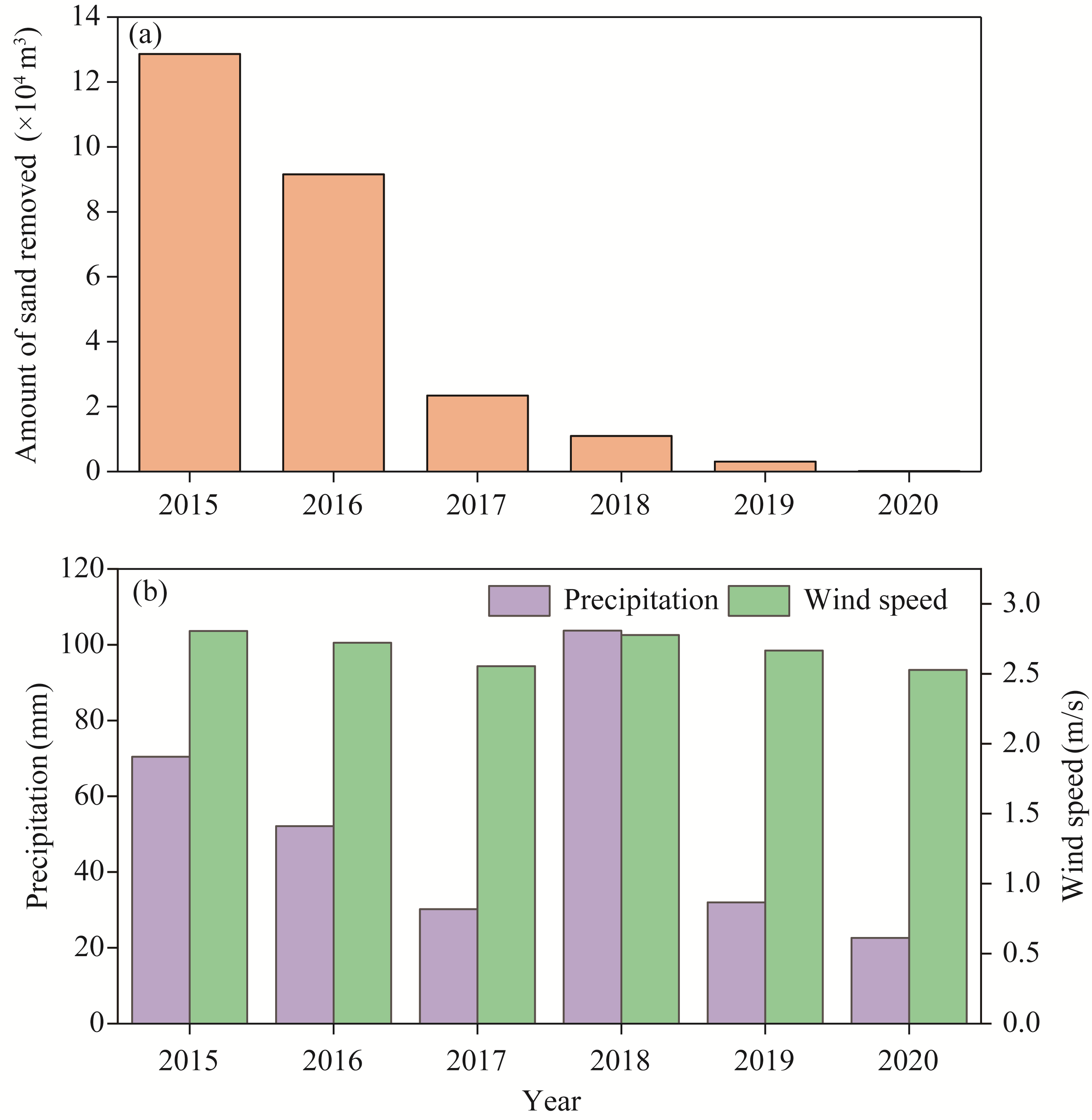
Abstract Sand control engineering plays a pivotal role in ensuring the safe operation of transportation corridors that traverse desertified areas. Evaluating the effectiveness of these interventions provides a crucial scientific basis for mitigating aeolian hazards and guiding the sustainable management of fragile and arid ecosystems. In this study, we investigated a representative section of Highway S315, which is prone to windblown sand hazards, in Ejin Banner, northern China. By integrating segmented measurements with unmanned aerial vehicle (UAV)-based oblique photogrammetry, we quantitatively characterized the spatial and temporal evolution of sand accumulation around multiple sand control structures and assessed their blocking efficiency. Complementary road sand-removal records and meteorological observations were analyzed to evaluate the long-term performance of engineering measures. Our results showed that sand accumulation behind high vertical sand barriers typically exhibited a triangular cross-sectional morphology, with a gently inclined stoss slope and a steep lee slope. The shape and volume of these deposits evolved dynamically in response to variations in the prevailing wind regime, reflecting strong feedback between barrier geometry and local airflow redistribution. In contrast, the low-profile checkerboard sand barriers displayed a three-stage morphological trajectory—initial accumulation, edge intensification, and functional decline—indicating a progressive loss of sand-trapping capacity as burial proceeded. Sand accumulation was markedly greater on the highway's western (upwind) side than on the eastern (downwind) side, with 70.0%-90.0% of the airborne sediment flux intercepted by the upwind structures. From 2015 to 2020, mean annual wind speeds remained stable (2.68±0.04 m/s), while precipitation varied from 22.6 to 103.7 mm. However, the annual sand removal volume from the road decreased consistently, confirming the enhanced mitigation effect of multi-level protective system. These findings highlight the coupled interactions between engineering design, wind-sand dynamics, and topographic context. Beyond their immediate protective role, well-designed sand control systems also contribute to the prevention of regional desertification by stabilizing mobile dunes and fostering conditions favorable for ecological restoration. The insights gained here provide both theoretical and practical support for optimizing sand control engineering and advancing sustainable hazard mitigation in arid and semi-arid areas.
|
|
Received: 25 August 2025
Published: 31 March 2026
|
|
Corresponding Authors:
*XIAO Jianhua (E-mail: xiaojh@lzb.ac.cn)
|
|
|
| [1] |
Akito K, Keiichi K, Susumu Y, et al. 2025. Effectiveness of sand-fixing measures for restoration of vegetation and mitigation of wind erosion and deposition in a degraded sandy rangeland, northern China. Ecological Engineering, 211: 107456, doi: 10.1016/j.ecoleng.2024.107456.
|
|
|
| [2] |
Bruno L, Horvat M, Raffaele L. 2018. Windblown sand along railway infrastructures: A review of challenges and mitigation measures. Journal of Wind Engineering and Industrial Aerodynamics, 177: 340-365.
doi: 10.1016/j.jweia.2018.04.021
|
|
|
| [3] |
Chen B N, Maurer J, Gong W B. 2025. Applications of UAV in landslide research: A review. Landslides, 22(9): 3029-3048.
doi: 10.1007/s10346-025-02547-2
|
|
|
| [4] |
Cheng J J, Lei J Q, Li S Y, et al. 2016. Effect of hanging-type sand fence on characteristics of wind-sand flow fields. Wind and Structures, 22(5): 555-571.
doi: 10.12989/was.2016.22.5.555
|
|
|
| [5] |
Dluzewski M, Rotnicka J, Hesp P A, et al. 2023. Airflow dynamics and aeolian sand transport across a beach-climbing dune-clifftop dune system. Journal of Geophysical Research: Earth Surface, 128(11): e2023JF007316, doi: 10.1029/2023jf007316.
|
|
|
| [6] |
Dun H C, Xin G W, Huang N, et al. 2021. Wind-tunnel studies on sand sedimentation around wind-break walls of Lanxin high-speed railway II and its prevention. Applied Sciences-Basel, 11(13): 5989, doi: 10.3390/app11135989.
|
|
|
| [7] |
Eltner A, Kaiser A, Castillo C, et al. 2016. Image-based surface reconstruction in geomorphometry-merits, limits and developments. Earth Surface Dynamics, 4(2): 359-389.
doi: 10.5194/esurf-4-359-2016
|
|
|
| [8] |
Gindraux S, Boesch R, Farinotti D. 2017. Accuracy assessment of digital surface models from unmanned aerial vehicles' imagery on glaciers. Remote Sensing, 9(2): 186, doi: 10.3390/rs9020186.
|
|
|
| [9] |
Horvat M, Bruno L, Khris S, et al. 2020. Aerodynamic shape optimization of barriers for windblown sand mitigation using CFD analysis. Journal of Wind Engineering and Industrial Aerodynamics, 197: 104058, doi: 10.1016/j.jweia.2019.104058.
|
|
|
| [10] |
Husemann P, Romao F, Lima M, et al. 2024. Review of the quantification of aeolian sediment transport in coastal areas. Journal of Marine Science and Engineering, 12(5): 755, doi: 10.3390/jmse12050755.
|
|
|
| [11] |
Koci J, Jarihani B, Leon J X, et al. 2017. Assessment of UAV and ground-based structure from motion with multi-view stereo photogrammetry in a gullied savanna catchment. ISPRS International Journal of Geo-Information, 6(11): 328, doi: 10.3390/ijgi6110328.
|
|
|
| [12] |
Kovanic L, Topitzer B, Petovsky P, et al. 2023. Review of photogrammetric and LiDAR applications of UAV. Applied Sciences, 13(11): 6732, doi: 10.3390/app13116732.
|
|
|
| [13] |
Lee S J, Park K C, Park C W. 2002. Wind tunnel observations about the shelter effect of porous fences on the sand particle movements. Atmospheric Environment, 36(9): 1453-1463.
doi: 10.1016/S1352-2310(01)00578-7
|
|
|
| [14] |
Li B L, Sherman D J. 2015. Aerodynamics and morphodynamics of sand fences: A review. Aeolian Research, 17: 33-48.
doi: 10.1016/j.aeolia.2014.11.005
|
|
|
| [15] |
Li Y L, Cui J Y, Zhang T H, et al. 2009. Effectiveness of sand-fixing measures on desert land restoration in Kerqin Sandy Land, northern China. Ecological Engineering, 35(1): 118-127.
doi: 10.1016/j.ecoleng.2008.09.013
|
|
|
| [16] |
Lima I A, Parteli E J R, Shao Y P, et al. 2020. CFD simulation of the wind field over a terrain with sand fences: Critical spacing for the wind shear velocity. Aeolian Research, 43: 100574, doi: 10.1016/j.aeolia.2020.100574.
|
|
|
| [17] |
Lin H S, Yu X G, Yu Z G, et al. 2020. Sand barrier morphological evolution based on time series remote sensing images: A case study of Anhaiao, Pingtan. Acta Oceanologica Sinica, 39(12): 121-134.
|
|
|
| [18] |
Liu J Q, Wu J, Kimura R. 2023. Evaluating the sand-trapping efficiency of sand fences using a combination of wind-blown sand measurements and UAV photogrammetry at Tottori Sand Dunes, Japan. Remote Sensing, 15(4): 1098, doi: 10.3390/ rs15041098.
|
|
|
| [19] |
Luo X Y, Li J R, Tang G D, et al. 2023. Interference effect of configuration parameters of vertical sand-obstacles on near-surface sand transport. Frontiers in Environmental Science, 11: 1215890, doi: 10.3389/fenvs.2023.1215890.
|
|
|
| [20] |
Ma X X. 2021. Sand control system and benefit analysis of the S 315 Ceda first-class highway. MSc Thesis. Lanzhou: Northwest Institute of Eco-Environment and Resources, Chinese Academy of Sciences. (in Chinese)
|
|
|
| [21] |
Michez A, Piégay H, Lisein J, et al. 2016. Classification of riparian forest species and health condition using multi-temporal and hyperspatial imagery from unmanned aerial system. Environmental Monitoring and Assessment, 188(3): 146, doi: 10.1007/s10661-015-4996-2.
|
|
|
| [22] |
Nesbit P R, Hugenholtz C H. 2019. Enhancing UAV-SfM 3D model accuracy in high-relief landscapes by incorporating oblique images. Remote Sensing, 11(3): 239, doi: 10.3390/rs11030239.
|
|
|
| [23] |
Ning Q Q, Li B L, Ellis J T. 2020. Fence height control on sand trapping. Aeolian Research, 46: 100617, doi: 10.1016/j.aeolia.2020.100617.
|
|
|
| [24] |
Niu C K, Zhao W, Zhao Y Y, et al. 2021. Avifauna and its ecological distribution in Ejina of Inner Mongolia. Journal of Arid Land Resources and Environment, 35(3): 168-173. (in Chinese)
|
|
|
| [25] |
Pähtz T, Clark A H, Valyrakis M, et al. 2020. The physics of sediment transport initiation, cessation, and entrainment across aeolian and fluvial environments. Reviews of Geophysics, 58(1): e2019RG000679, doi: 10.1029/2019rg000679.
|
|
|
| [26] |
Qu J J, Wang T, Niu Q H, et al. 2023. Mechanisms of the formation of windblown sand hazards and the sand control measures in Gobi areas under extremely strong winds along the Lanzhou-Xinjiang high-speed railway. Science China-Earth Sciences, 66(2): 292-302.
doi: 10.1007/s11430-021-1000-6
|
|
|
| [27] |
San B B, Zhao Y Y, Qiu Y. 2019. Numerical simulation and optimization study of surface pressure and flow field around a triangular prism behind a porous fence. Environmental Fluid Mechanics, 19(4): 969-987.
doi: 10.1007/s10652-019-09695-9
|
|
|
| [28] |
Solazzo D, Sankey J B, Sankey T T, et al. 2018. Mapping and measuring aeolian sand dunes with photogrammetry and LiDAR from unmanned aerial vehicles (UAV) and multispectral satellite imagery on the Paria Plateau, AZ, USA. Geomorphology, 319: 174-185.
doi: 10.1016/j.geomorph.2018.07.023
|
|
|
| [29] |
Tang L N, Shao G F. 2015. Drone remote sensing for forestry research and practices. Journal of Forestry Research, 26(4): 791-797.
doi: 10.1007/s11676-015-0088-y
|
|
|
| [30] |
Vos S, Anders K, Kuschnerus M, et al. 2022. A high-resolution 4D terrestrial laser scan dataset of the Kijkduin beach-dune system, the Netherlands. Scientific Data, 9(1): 191, doi: 10.1038/s41597-022-01291-9.
|
|
|
| [31] |
Wang T, Qu J J, Ling Y Q, et al. 2017. Wind tunnel test on the effect of metal net fences on sand flux in a Gobi desert, China. Journal of Arid Land, 9(6): 888-899.
doi: 10.1007/s40333-017-0068-5
|
|
|
| [32] |
Wang T, Liu B L, Niu Q H, et al. 2024. Sediment transportation by strong winds over Gobi surfaces: Field observations along the Lanzhou-Xinjiang high-speed railway. Land Degradation & Development, 35(13): 4011-4023.
doi: 10.1002/ldr.v35.13
|
|
|
| [33] |
Woodget A S, Austrums R, Maddock I P, et al. 2017. Drones and digital photogrammetry: From classifications to continuums for monitoring river habitat and hydromorphology. Wiley Interdisciplinary Reviews-Water, 4(4): e1222, doi: 10.1002/ wat2.1222.
|
|
|
| [34] |
Wu J J, Li Y, Zhong B, et al. 2024. Synergistic coupling of multi-source remote sensing data for sandy land detection and multi-indicator integrated evaluation. Remote Sensing, 16(22): 4322, doi: 10.3390/rs16224322.
|
|
|
| [35] |
Wu W C, Liu Y L. 2022. Editorial for the special issue: "Integrated applications of geo-information in environmental monitoring". Remote Sensing, 14(17): 4251, doi: 10.3390/rs14174251.
|
|
|
| [36] |
Xie S B, Qu J J, Pang Y J. 2017. Dynamic wind differences in the formation of sand hazards at high and low-altitude railway sections. Journal of Wind Engineering and Industrial Aerodynamics, 169: 39-46.
doi: 10.1016/j.jweia.2017.07.003
|
|
|
| [37] |
Xie Y H, Dang X H, Zhou Y J, et al. 2020. Using sediment grain size characteristics to assess effectiveness of mechanical sand barriers in reducing erosion. Scientific Reports, 10(1): 14009, doi: 10.1038/s41598-020-71053-3.
|
|
|
| [38] |
Yao Z Y, Chen G T, Han Z W, et al. 2006. Decline mechanism and process of mechanical defense system. Journal of Desert Research, 26(2): 226-231. (in Chinese)
|
|
|
| [39] |
Yao Z Y, Xiao J H, Ma X X, et al. 2025. Evaluation of the effectiveness of an expressway sand protection system in a Gobi region—case study of the Ceke-Ejina expressway, Ejina Banner, China. International Soil and Water Conservation Research, 13(1): 177-188.
doi: 10.1016/j.iswcr.2024.09.003
|
|
|
| [40] |
Yu Y P. 2018. Study on sand transport patterns of subgrade cross-section forms of high-grade highways: A case study of the S 315 first-class highway in Inner Mongolia. MSc Thesis. Lanzhou: Northwest Institute of Eco-Environment and Resources, Chinese Academy of Sciences. (in Chinese)
|
|
|
| [41] |
Yu Y P, Xiao J H, Qu J J, et al. 2019. Wind tunnel simulation of aeolian sand process in subgrade section of two typical high-grade highway. Journal of Desert Research, 39(1): 68-79. (in Chinese)
doi: 10.7522/j.issn.1000-694X.2018.00046
|
|
|
| [42] |
Yu Y P, Ke Z C, An Z S, et al. 2020. The blocking effect of the sand fences quantified using wind tunnel simulations. Journal of Mountain Science, 17(10): 2485-2496.
doi: 10.1007/s11629-020-6095-2
|
|
|
| [43] |
Zhang C H, Kovacs J M. 2012. The application of small unmanned aerial systems for precision agriculture: A review. Precision Agriculture, 13(6): 693-712.
doi: 10.1007/s11119-012-9274-5
|
|
|
| [44] |
Zhang H X, Zhang K C, An Z S, et al. 2023. Wind dynamic environment and wind-sand erosion and deposition processes on different surfaces along the Dunhuang-Golmud railway, China. Journal of Arid Land, 15(4): 393-406.
doi: 10.1007/s40333-023-0099-z
|
|
|
| [45] |
Zhang J Q, Zhang C L, Zhou N, et al. 2011. Spatial pattern of grain-size distribution in surface sediments as a result of variations in the aeolian environment in China's Shapotou railway protective system. Aeolian Research, 3(3): 295-302.
doi: 10.1016/j.aeolia.2011.07.005
|
|
|
| [46] |
Zhang J T, Xi H Y, Wang C L, et al. 2019. Estimation of evapotranspiration of riparian forests in the desert region from diurnal fluctuation of groundwater levels. Plateau Meteorology, 38(1): 179-186. (in Chinese)
doi: 10.7522/j.issn.1000-0534.2018.00071
|
|
|
| [47] |
Zhang T H, Zhao H L, Li S G, et al. 2004. A comparison of different measures for stabilizing moving sand dunes in the Horqin Sandy Land of Inner Mongolia, China. Journal of Arid Environments, 58(2): 203-214.
doi: 10.1016/j.jaridenv.2003.08.003
|
|
|
|
Viewed |
|
|
|
Full text
|
|
|
|
|
Abstract
|
|
|
|
|
Cited |
|
|
|
|
| |
Shared |
|
|
|
|
| |
Discussed |
|
|
|
|