

 ,
, In developing countries such as Ethiopia, research to develop and promote soil and water conservation practices rarely addressed regional diversity. Using a water-balance approach in this study, we used runoff plots from three sites, each representing a different agro-ecological environment, e.g.,high, mid and low in both elevation and rainfall, in the Upper Blue Nile Basin of Ethiopiato examine the runoff response and runoff conservation efficiency of a range of different soil and water conservation measures and their impacts on soil moisture. The plots at each site represented common land use types (cultivated vs. non-agricultural land use types) and slopes (gentle and steep). Seasonal runoff from control plots in the highlands ranged 214-560 versus 253-475 mm at midlands and 119-200 mm at lowlands. The three soil and water conservation techniques applied in cultivated land increased runoff conservation efficiency by 32% to 51%, depending on the site. At the moist subtropical site in a highland region, soil and water conservation increased soil moisture enough to potentially cause waterlogging, which was absent at the low-rainfall sites. Soil bunds combined with Vetiveriazizanioides grass in cultivated land and short trenches in grassland conserved the most runoff (51% and 55%, respectively). Runoff responses showed high spatial variation within and between land use types, causing high variation in soil and water conservation efficiency. Our results highlight the need to understand the role of the agro-ecological environment in the success of soil and water conservation measures to control runoff and hydrological dynamics. This understanding will support policy development to promote the adoption of suitable techniques that can be tested at other locations with similar soil, climatic, and topographic conditions.
Over the last three decades, the government of Ethiopia and a consortium of donors have invested substantial resources to develop and promote sustainable land management practices as part of efforts to improve environmental conditions, ensure sustainable and increased agricultural production, and reduce poverty (Herweg and Ludi, 1999; Nyssen et al., 2000; Kassie et al., 2009;Adgo et al., 2013; Adimassu et al., 2014; Amare et al., 2014; Haregeweyn et al., 2015, 2017). Some of the major physical soil and water conservation techniques being used in the country include short trenches, soil and stone bunds, cut-off drains, check dams, hillside terraces, area closures,Fanyajuu (a Swahili word meaning 'throw uphill'), and Zai pits (a term in Burkina Faso used to refer digging pits that retain compost and direct water into the soil surrounding each plants to grow).Recently, physical structures have been combined with biological measures such as vegetation establishment to protect the soil against erosion (Amare et al., 2014). But despite these efforts, the sustainability of the development work is unclear. Due to low rates of adoption, most of the promoted practices have been only partially successful. In some cases, disadoption or reduced use of the techniques has been reported (Tadesse and Belay, 2004).
Past efforts to develop and promote soil and water conservation practices had neglected the pronounced regional diversity of Ethiopia. Haregeweyn et al. (2015) andSultan et al. (2017) found that the impact of these interventions was influenced by both the type of measurement and the agro-ecosystem under which it was implemented. Landscape, land use, soils, hydrological processes, and climate can be highly variable across regions, and their linkages to the success of environmental management practices are important aspects that must be understood and documented (Melesse and Abtew, 2016). In addition, Bayabil et al. (2010)illustrated that the effectiveness of a soil and water conservation practice depends on whether watershed runoff processes depend primarily on the localecosystem, topography, or a combination of the two. The suitability of any soil and water managementpractice depends greatly upon the soil, topography, climate, cropping system, andresources available to farmers (Pathak et al., 2009). Overall, an agro-ecological approach can contribute substantially to sustainable intensification of agriculture, but this must supported by an improved knowledge of the optimal conservation measure for each combination of site type and land use (Lampkin et al., 2015).
In Ethiopia, the distribution and amount of rainfall show great spatial and temporal variation, which is strongly influenced by altitude (Rientjes et al., 2013; Schmidt and Zemadim, 2013; Fenta et al., 2017a). Bekele-Tesemma et al. (2005)suggested that temperature (which is determined by the altitude) and rainfall are the two most important climatic factors that affect land management from the point of view of farmers or development agents. Hurni et al. (2016)developed general soil and water conservation guidelines in which they noted that climate varies greatly within Ethiopia, which ranges from dry to wet, and covers a range of elevations from lowlands to highlands. As a result, it is not possible to apply the same soil and water conservation techniques everywhere. This conclusion was based on a feasibility study of different physical conservation measures that had been tested in micro-watersheds (soil conservation research sites) in different agro-ecology systems that had been monitored 25 years ago (Herweg and Ludi, 1999).
Gradually, a few agro-ecology based studies have emerged, but most focused on evaluation of the socioeconomic aspects (Kassie et al., 2009; Matouš et al., 2013; Schmidt and Zemadim, 2013; Hurni et al., 2015; Nigussie et al., 2017).Studies on the efficiency of soil and water conservation are few, and most concentrated on the combination of a single agro-ecology with a specific conservation measure (Taye et al., 2013; Adimassu et al., 2014; Amare et al., 2014; Dagnew et al., 2015; Fenta et al., 2017b;Sultan et al., 2017). However, these studies also lack detailed information about the hydrological dynamics created by the conservation efforts across a range of land use, cover types, and slope classes. Best management practice should encompass a series of measures that areuseful, proven to be effective, cost-effective, and generally accepted among conservation experts and the ultimate users for specific agro-ecology systems. Hence, critical analysis of the runoff responses and efficiency of the available measures under different agro-ecologysystems is needed to evaluate which particular sustainable land management interventions are most likely to be successful in a given location.This suggests a need for analyses that examine the interactions between various location-specific factors. The results of such observations will provide greater insight into how soil and water conservation affects the hydrological processes under different agro-ecology systems. To provide some of the missing knowledge, we usedplot-level runoff measurements and hydrological analyses at three different agro-ecological sites in the Amhara and BenishangulGumuz administrative regions of Ethiopia. Our objectives were (1) to analyze the spatial variability of rainfall-runoff relationship and its controlling factors and (2) to determine the ability of different soil and water conservation practices to reduce runoff and improve soil moisture availability in typical agro-ecology systems in the Upper Blue Nile Basin of Ethiopia.
We established experimental runoff plots to represent the different land use and cover types and different slope gradients at three experimental sites (Fig. 1): the Guder and Aba Gerima watersheds from the FagitaLekoma (10°57′-11°11′N, 36°40′-37°05′E) and Bahir Dar Zuria (11°25′-11°55′N, 37°04′-37°39′E) districts, respectively, of the Amhara Region, and the Dibatie watershed from the DibatieDistrict (10°01′-10°53′N, 36°04′-36°26′E) of the BenishangulGumuz Region. These sites were selected to represent three important agro-ecology systems in the Upper Blue Nile Basin having different annual precipitation, elevation, experiences with soil and water conservation, soil erosion rates, and land use types (Tables 1 and 2).
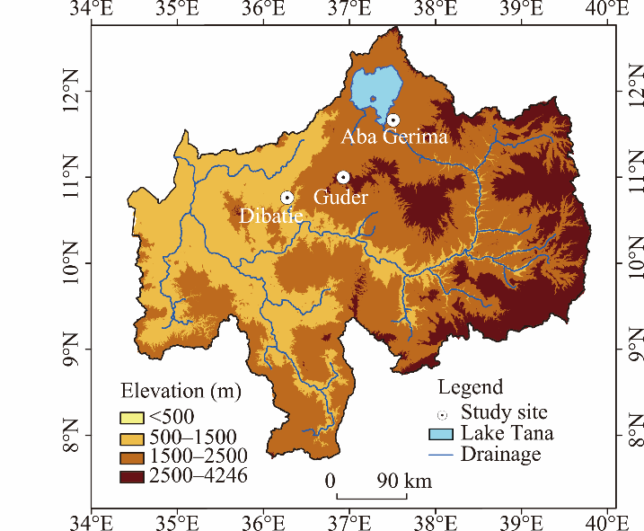
Fig. 1
Location of the study sites with different agro-ecology systems
Each study site has been part of the national government's regular extension programs and other public based soil and water conservation interventions, but the experiences of these study siteswith other externally funded programs have varied greatly (Nigussie et al., 2017). The Aba Gerima watershed has been part of the Water and Land Resource Centre,which is funded by the Swiss Agency for Development and Cooperation, since 2011. The Guder watershed has received support for soil and water conservation initiatives from the World Bank under theSustainable Land Management Programme since 2008. Dibatie has had no external funding support for conservation projects.The major but most common soil and water conservation measures implemented in the Upper Blue Nile Basin of Ethiopia are the creation of soil bunds (i.e., raised soil embankment from the ditch is moved downhill that block the flow of water), Fanyajuu (i.e., raised soil embankment from the ditch is moved upslope), short trenches (i.e., excavating trenches along the contour at the hillside), and soil bunds combined with vegetation establishment to protect the soil (Haregeweyn et al., 2015;Fig. 2). Soil bunds and Fanyajuu were constructed by building soil walls (about 0.5-1.0 m high) along the contour have similar dimensions of 1.6 m wide and 6.0 m long with variable spacing depending on land use and slope. Soil faced short trenches were constructed by excavating trenches of 0.5 m deep, 1.4 m wide and 1.5-2.5 m long with spacing between trenches of 1.7 m along the contour.
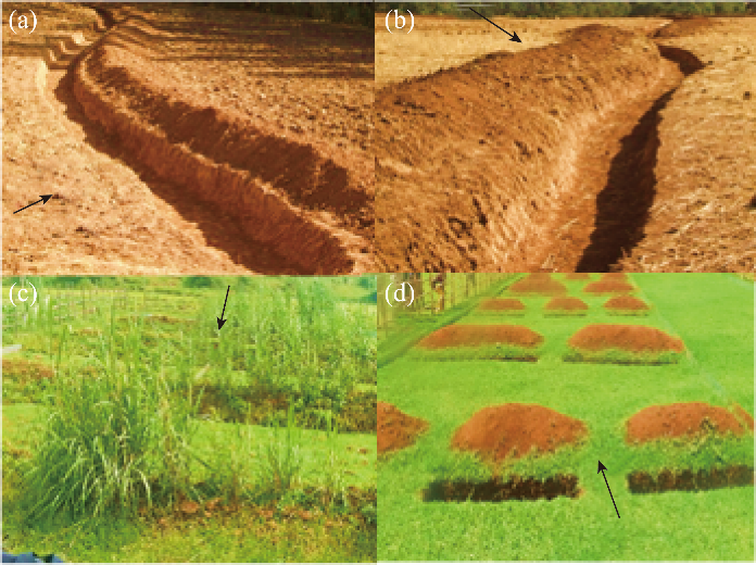
Fig.2
Commonly implemented soil and water conservation measures for the major land use typesin the three agro-ecology systems in the Upper Blue Nile Basin of Ethiopia.(a), soil bunds; (b),Fanyajuu in cultivated land; (c),soil bunds combined with planting of vegetation (here, elephant grass) in cultivated land; and (d), short trenches in grazing land. Thearrows indicate the slope direction.
Although the overall slope at each site does not change, the effective slope length (the distance between conservation structures) decreases; the principle is to reduce the speed of the flowing water when it contacts each structure and the volume of water that reaches the slope downhill of that structure, thereby reducing the runoff volume.Soil and water conservation measures are applied to even and uneven grounds in the Upper Blue Nile Basinby using different designs.
Each study site was equipped with a temperature sensor and datalogger(Mini-diver, Schlumberger Water Services, Netherland)and one manual rain gauge. The dataloggerwas programmed to measure the maximum and minimum air temperature at 10-min intervals. We screened this data by taking the maximum and minimum temperatures from 144 readings and calculated a daily average temperature, which we used to calculate potential evapotranspiration at each site.The rain gauge recorded daily rainfall in the rainy season from June toOctober 2015.More than 86% of the rainfall in the region is concentrated inthese months (Sultan et al., 2017).
We measured runoff at the plot scale using a total of 42 runoff plots (30 m long×6 m wideeach) in the three agro-ecology systems with 18 at Guder, 12 at Aba Gerima, and 12 at Debatie. We used four treatmentsfor the cultivated land on gentle and steep slopes; and two treatments for the non-agricultural land on steep slopes. Each agro-ecology system comprised cultivated land in two slope ranges (5% and 15%), grazing land (15% slope), and degraded bush (35% slope) plots. However; the Guder site had two additional main land use types,Acacia decurrens plantations (5% and 25% slopes), and Eucalyptus spp. plantations (25% slopes). We divided the plots into a group with gentle slopes (<15°) and a group with steep slopes (≥15°).
Each cultivated land plot had a different soil and water conservation treatment (soil bund, Fanyajuu, soil bund with vegetation establishment, and a control without treatment). Each other non-agricultural landuse types (grazing land, degraded bush, A.decurrens plantations, and Eucalyptusspp. plantations) each had two treatments (short trenches and control).Based on their availability of sufficient soil and plant species and the ongoing sustainable land management practices,details of the soil bund with vegetation establishment treatment varied among the sites. In the Gudercultivated land plots, the soil bunds were reinforced and stabilized by planting vegetation such as tree lucerne (Cytisusproliferus)and densho grass (Pennisetumpedicellatum)together, whereas elephant grass (Pennisetumpurpureum) and vetiver grass (Vetiveriazizanioides) were planted at the Aba Gerima and Debatie sites, respectively.
At the lower end of each plot, we excavated a 9.7-m3 pit with a trapezoidal cross section (Fig.3) and lined the pit with an impermeable geomembrane plastic to permit the collection of sediment and runoff. The pits were designed to accommodate the maximum runoff that would result from extreme rainfall events, predicted using the anticipated rainfall (based on historical records at the nearest meteorological station) and a runoff coefficient of 46% (Herweg and Ludi 1999; Haregeweyn et al., 2016). The runoff depth corresponding to each daily rainfall was recorded and used for our runoff analysis. An equation that related the water depth in the pit to the volume of the pit was established for each trapezoidal pit by adding a known volume of water. Then, based on this relationship, the runoff volume was calculated from runoff depth measurements taken every morning at around 08:00 am LSTwith a measuring tape at an average of six points in the pit to account for variations in water depth due to bottom irregularities. The effect of direct rain falling into the pit (estimated from the rain gauges) was subtracted from the total. The plots were also bounded at the sides to prevent inflows of runoff and sediment from the sides of the plot using sheets of corrugated metal inserted into the ground to a depth of 15 cm and protruding 20 cm above the ground (Fig. 3c). Finally, the runoff depth was calculated by dividing the net runoff volume collected from the pit to the runoff plot area.
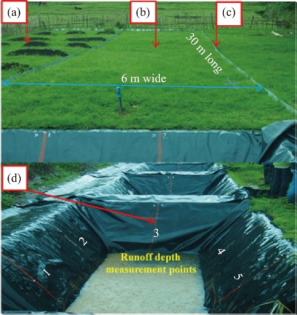
Fig. 3
Layout of the runoff plots established in grazing land in the Guder watershed.(a), plots with soil and water conservation measures; (b), plots without conservation measures; (c), corrugated iron sheets inserted in the ground to a depth of 15 cm to establish the plot boundaries; (d), runoff collection pit lined with impermeable geomembrane plastic. Water depth was measured at the six numbered points (1-6) on the liner (Sultan et al., 2017), with the point No. 6 in the opposite side of No. 3.
The values of various soil variables were determined to characterize each site (Table 1). Three samples were taken from the top 30 cm of the soil profile at intervals of 10cm for each landuse typeand analyzed to determine the texture using the hydrometric method (Sheldrick and Wang, 1993) and the average of the particle-size distributions were used to characterize the site.Undisturbed soil samples were taken to a depth of 30 cm at 10-cm intervals using a core sampler with a volume of 100 cm3to determine the soil bulk densityto determine the bulk density. The samples were then oven-dried at 105°C for 24 h and weighed. The bulk density was determined by dividing the weight of the oven-dried soil samples by the volume of the soil core.Soil penetration resistance (SPR(kPa)) was measured by using a hand-operated soil cone penetrometer (Hand penetrometer, Eijkelkamp Company, the Netherlands) with a cone (2-cm2 base size) and a driving shaft graduated at 5-cm intervals. For each site, we calculated the SPR as the average of 30 observations.
Table 1
Main characteristics of research sites
Table 2 summarizes the characteristics of the soil and water conservation measures implemented in the runoff plots. The slope of the plot was measured with a clinometer (PM-5/360 PC Clinometer, Suunto, Finland).The dimensions of each conservation measure were based on the standard practices in the study area. The short trenches were installed in two rows across the slope by excavating the soil to a depth of 0.5 m: the upslope row comprised shorter lengths (1.4 m×1.5 m) separated by 0.5 m and the downslope row comprised longer lengths (1.4 m×2.5 m for the A. decurrens, grazed grassland, Eucalyptusspp., and degraded bush sites; 1.6 m×6.0 m for the cultivated sites; Table 2). The long and short axis of the excavations were oriented perpendicular to the slope.
Table 2
Characteristics of the 30 m×6 m runoff plots used to study the effects of land use and soil and water conservation (SWC) practices on runoff in Ethiopia
We analyzed the plot data for seasonal runoff, runoff coefficient (RC), runoff conservation efficiency (RCE), and seasonal soil moisture availability. We quantified the relationships between daily rainfall and runoff depth by means of regression analysis. RCwas calculated by Equation 1.
$RC=(Runoff depth/\text{Rainfall depth})\times 100%$.(1)
Runoff conservation efficiency (RCE) in each plot was calculated relative to runoff in the corresponding control plot using Equation 2(Herweg and Ludi, 1999; Sahoo et al., 2016).
$\text{RCE}=\frac{\left( A-B \right)}{A}\times 100%$, (2)
whereA is the runoff loss (mm) from the control plot andB is the runoff loss (mm) from the corresponding plot with a conservation measure.
Seasonal moisture conservation efficiencywas measured by the change in seasonal water availability analyzed for all runoff plots using the water-balance equation (Eq. 3; Dingman, 2015).
$\Delta S=P-Q-\text{ET}$,(3)
where ∆S (mm) is the seasonal change in moisture stored in the soil (includingdeep percolation beyond the soil zone);P is the seasonal precipitation (mm);Q is seasonal measured runoff (mm); and ETis seasonal evapotranspiration (mm). Since accurate field measurements are often difficult to acquire, evapotranspiration is usually estimated as the potential evapotranspiration (PET). Given the limited long-term meteorological data available for the study watersheds, we used the temperature-based method (Eq. 4) developed by Hargreaves and Samani (1985) to calculate PET.
$\text{PET}=0.0023\times Ra\times \left[ \frac{{{T}_{\max }}+{{T}_{\min }}}{2}+17.8 \right]\times {{\left( {{T}_{\max }}-{{T}_{\min }} \right)}^{0.5}}$, (4)
where Ra is the solar radiation (mm/day) estimated based on the approach suggested by Allen et al. (1998);Tmax is the daily maximum temperature (°C) and Tmin is the daily minimum temperature (°C).
Table 3 summarizes the cumulative rainfall and cumulative runoff during the rainy season, RC, and RCE for all plots. The seasonal rainfall totaled 1568 mm for Guder, 1402 mm for Aba Gerima, and 881 mm for Debatie. The seasonal runoff from control plots in the Guder watershed ranged from 214 to 560 mm, versus 253 to 475 mm at Aba Gerima and 119 to 200 mm at Debatie. The highest runoff was 560 mm, in grazing land control plots on steep slopes at Guder (GR2), and the lowest was 81 mm, in short trench plots on steep slopes at Debatie (DB2).The cumulative runoff wasthe lowest at Debatie, which was the site with by far the lowest precipitation. Changes in precipitation regimes clearly have the potential to profoundly affect runoff and soil erosion. Lee et al. (1996)confirmed that the precipitation hada linear relationship with runoff and soil erosion, with little difference in runoff response to a change in storm frequency or intensity.The grazing land site on a steep slope (GR2) generated the highest seasonal runoff at Guder (560 mm), followed by the same site type at Aba Gerima (475 mm) and Debatie (134 mm); the high runoff in Guder might be related to frequent trampling by animals because the site was used for grazing livestock. As a result, we found compacted topsoil surfaces in grazing lands, with the highest soil penetration resistance (SPR ranging from 1990 to 2210 kPa), versus a maximum of 1100-1660 kPa for the other land use types. This reduced infiltration and thereby increased runoff. A similar analysis for the Upper Blue Nile Basin showed that cattle on wet grazing soils caused additional compaction in the top 30 cm soil layers (Tebebu et al., 2015), leading to higher runoff production.
Table 3
Runoff conservation efficiency (RCE) and runoff coefficient (RC)for the different land use types and different SWC practices in the three agro-ecology systems during the rainy season from June to October 2015
Although higher surface runoff is expected from control plots on steeper slopes (35%), surface runoff from plots with degraded bush was lower than that from the other land use types, except for cultivated land at Aba Gerima (Table 3). This can be explained, on the one hand, by the direct effect of raindrop interception by the vegetation canopy, which dissipates their energy and creates infiltration pathways (Morgan et al., 1986; Castillo et al., 1997;Descroix et al., 2001). On the other hand, vegetation decreases runoff indirectly by improving soil physical properties through the incorporation of organic matter (16.7% in Guder;Sultan et al., 2017) and loosening of the soil by growing roots, thereby increasing the infiltration rate (Descheemaeker et al., 2006). Taye et al. (2013)explained this in a different way; they reported that RC decreased with increasing slope due to an increase in the content of coarse particles in the soil, which promoted infiltration. Similarly,Tebebu et al. (2015)illustrated that, for saturation-excess runoff, water infiltrates on hillsides and erosion-inducing runoff occurs in the flatter, downslope parts of landscapes. This, in turn, affects the hydrology, since excess water flows more rapidly to valley bottoms as lateral flow, leading to gully formation (Bayabil et al., 2010).All of these factors may have combined to overwhelm the slope effect.
Taking into account the interactions between the soil and water conservation measures and the two dominant land use types, which were cultivated land on steep slopes (CL2) and grazing land (GR2), we calculated the rainfall thresholds required to generate runoff for both of these at each agro-ecology system (Fig. 4;Table 4). The threshold rainfall can be determined by plotting the daily runoff depth against the corresponding rainfall depth (Fig. 4) and performing least-squares regression (Descheemaeker et al., 2006; Girmay et al., 2009). The slope of the regression line represents how rapidly runoff depth increases with increasing rainfall depth after the rainfall threshold is exceeded. The threshold rainfall values were selected based on the probability of 80% of events below the threshold level rainfall failing to produce runoff. The higher the rainfall threshold and the lower the slope of the curve, the higher the infiltration rate and greater the storage capacity of the soil in the agro-ecology system (Descheemaeker et al., 2006; Girmay et al., 2009).
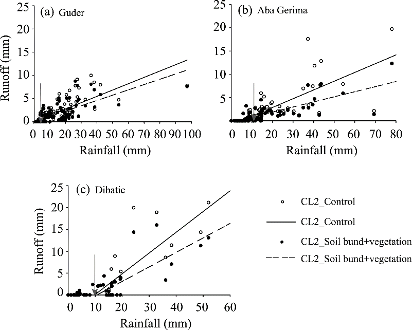
Fig. 4
Regressions of runoff as a function of rainfall (excluding the events that produced no runoff) and its use to determine the rainfall thresholds (arrows) for six plot types: CL2_Control, cultivated control plots on steep slopes; CL2_Soil bund+vegetation, cultivated plots on steep slopes with a soil bund combined with vegetation establishment.
Table 4
Rainfall threshold (T) required to generate runoff, and slope of the rainfall-runoff curve for each plot at the three study sites.
The biggest rainfall event at Guder was 97 mm, versus 78 mm at Aba Gerima and 53 mm at Debatie. In the Guder watershed, the rainfall threshold values for runoff generation were 6 and 5 mm in cultivated land (CL2) and grazing land (GR2) on steep slopes, respectively(Table 4). For the same land use types, the largest rainfallthreshold values were obtained at the Dibatie and Aba Gerima sites, with thresholds of more than 10 and 9 mm, respectively. The slope of the rainfall-runoff curve also varied widely among the plots; with the values of 0.10-0.45. The soil and water conservation practices using vegetated soil bunds and short trenches in the cultivated and grazing land plots resulted in a lower slope of the curve than in the corresponding control plots at all three sites (Table 4). This can be attributed to storage of runoff in depressions and slowing of the runoff flow by the conservation structures.
The response of runoff to rainfall at the moist subtropical site (Guder) began sooner (i.e., a lower rainfall threshold) than that at the humid subtropical (Aba Gerima) and the tropical hot humid (Debatie) sites (Table 4). Sultan et al. (2017) reported that Guder receives long-lasting rainfall events with small amounts of rainfall, and yet that this site has a longer rainy season than other sites in the western and central highlands; nonetheless, the higher proportion of rainfall (63%) that comes from light rainfall events, which influences subsequent availability of soil moisture. In addition, the heavy soils of the Guder watershed (Table 1) tend to retain moisture for a longer period, and this can lower the threshold rainfall compared with other sites. Therefore, small increases in precipitation could result in waterlogging and damage to soil and water conservation structures if subsequent precipitation occurs as intense storms that deposit more rain than the threshold value.
On average, the rainfall threshold values at our study sites are higher than those in semi-arid regions of northern Ethiopia (the Tigray region). For example, Descheemaeker et al. (2006) obtained rainfall threshold values ranging from3 to 16 mm in plots with different land use types. Similarly, Girmay et al. (2009) reported that rainfallevents>2 mm produced runoff in cultivated land, whereas rainfall events>3 mm produced runoff in both grazing land and plantation areas. This illustrates the lower interception capacity of vegetation canopies at semi-arid sites and the lower infiltration capacity of soils in drier environments (Pilgrim et al., 1988). It is worth noting that the experimental plot dimensions (5 m×2 m and 10 m×2 m in the previous studies, both of which were much smaller than the dimensions in the present study) can strongly affect the results of such studies, as the runoff amount is strongly influenced by scale effects (Bergkamp, 1998).
The percentage of seasonal rainfall lost as runoff from control plots in the Guder watershed ranged from 14% to 36%, versus 18% to 40% at Aba Gerima and 14% to 23% at Dibatie (Table 3), demonstrating the high variability of RC across the three studied environments.RCalso differed between the control and treatment plots at each site.
Monthly RC was the highest in July and August in most treatments and decreased during September and October at all sites (Fig. 5). This can be explained by decreasing rainfall at the end of the rainy season combined with increasing vegetation cover during the rainy season, which would decrease runoff generation.
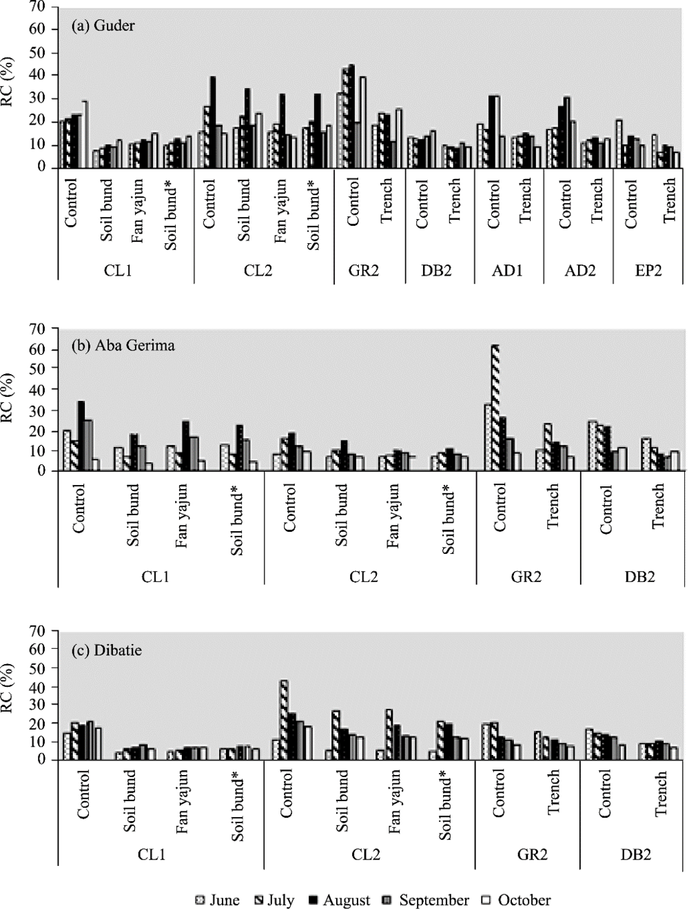
Fig. 5
Seasonal patterns of runoff coefficient (RC)values (%) under different combinations of soil and water conservation measures and combinations of land use type. CL, cultivated land; GR, grazing land; AD, A.decurrens plantation; EP, Eucalyptus spp. plantation; DB, degraded bush;1, gentleslope; 2 steepslope; *, soil bund combined withvegetation establishment.
The knowledge provided by the present study about the RC of various land use typesunder different agro-ecology systems is essential to support estimates of runoff from a given watershed under a given land use. This, in turn, can help land managers to design appropriate water-harvesting structures, such as drainage canals, waterways, and reservoirs, and to predict flood hazards (Adimassu and Haile, 2011; Haregeweyn et al., 2016).
At the Guder site, the RCEof the soil and water conservation measures ranged from 27%to 47%, versus 25% to 51% at Dibatie and 35% to 55% at Aba Gerima(Table 3). In general, the highest RCE was obtained for plots treated with soil bunds combined with vegetation establishment based on the average for cultivated land. The soil bunds combined with vetiver grass (V.zizanioides) at Debatie were more effective (RCE, 51%) than those with tree lucerne (C.proliferus),densho grass (P.pedicellatum; RCE, 32%) andelephant grass (P.purpureum; RCE, 36%). In contrast, Amare et al. (2014) obtained the lowest runoff values for soil bunds combined with elephant grass, followed by soil bunds combined with the legume species Tephrosia in the northwestern Ethiopian highlands, and they also suggested that vetiver grass required a longer establishment period before it could begin to conserve soil and water efficiently.For the plots in non-agricultural land, the highest RCE(55%) was obtained in GR2 plots treated with short trenches at the Aba Gerima site. On average, the establishment of soil and water conservation measures decreased runoff by 35%, 41%, and 42% at the Guder, Debatie, and Aba Gerima sites, respectively.Thus,there is strong evidence that the adoption of soil and water conservation practices can reduce runoff more in areas with low rainfall than in areas with high rainfall.This is because dry soils have higher infiltration capacity than wet soils during the rainy season.
Higher RCE was obtained in all treatments in plots with a gentle slope than in the comparable treatment in plots with a steep slope due to the greater difference in runoff between the treated and control plots.In general, creating short trenches and soil bunds combined with vegetation establishment produce better runoff reduction than the other practices, especially in grazing landand cultivated land.
The combination of the distinctive features of the agro-ecology system, of the soil and water conservation practices, and of the associated hydrological processes affected the seasonal water availability in the plots (Fig. 6). The seasonal potential evapotranspiration values were 579, 675, and 732 mm for the Guder, Dibatie, and Aba Gerima sites, respectively, which were determined by the Hargreaves and Samani (1985) equation. The soil water availability (Fig. 6) obtained by means of the water-balance method ranged from 428 to 830, 394 to 515, and 7 to 124 mm for the Guder, Aba Gerima, and Dibatie sites, respectively. The differences in these ranges can be attributed to differences in the frequency of rainfall (amount), soil type, runoff amount (Table 3), and potential evaporation among the different agro-ecologysystems. On average, implementation of soil and water conservation measures increased seasonal water availability by about 139 mm compared with the control plot at the Guder site, versus 130 and 67 mm at the Aba Gerima and Debatie sites,respectively (Fig. 6). This indicates that the infiltration and runoff dynamics were also influenced by slope length, because the reduction of slope length caused by installation of the conservation structures increased storage and thereby reduced the volume of runoff.
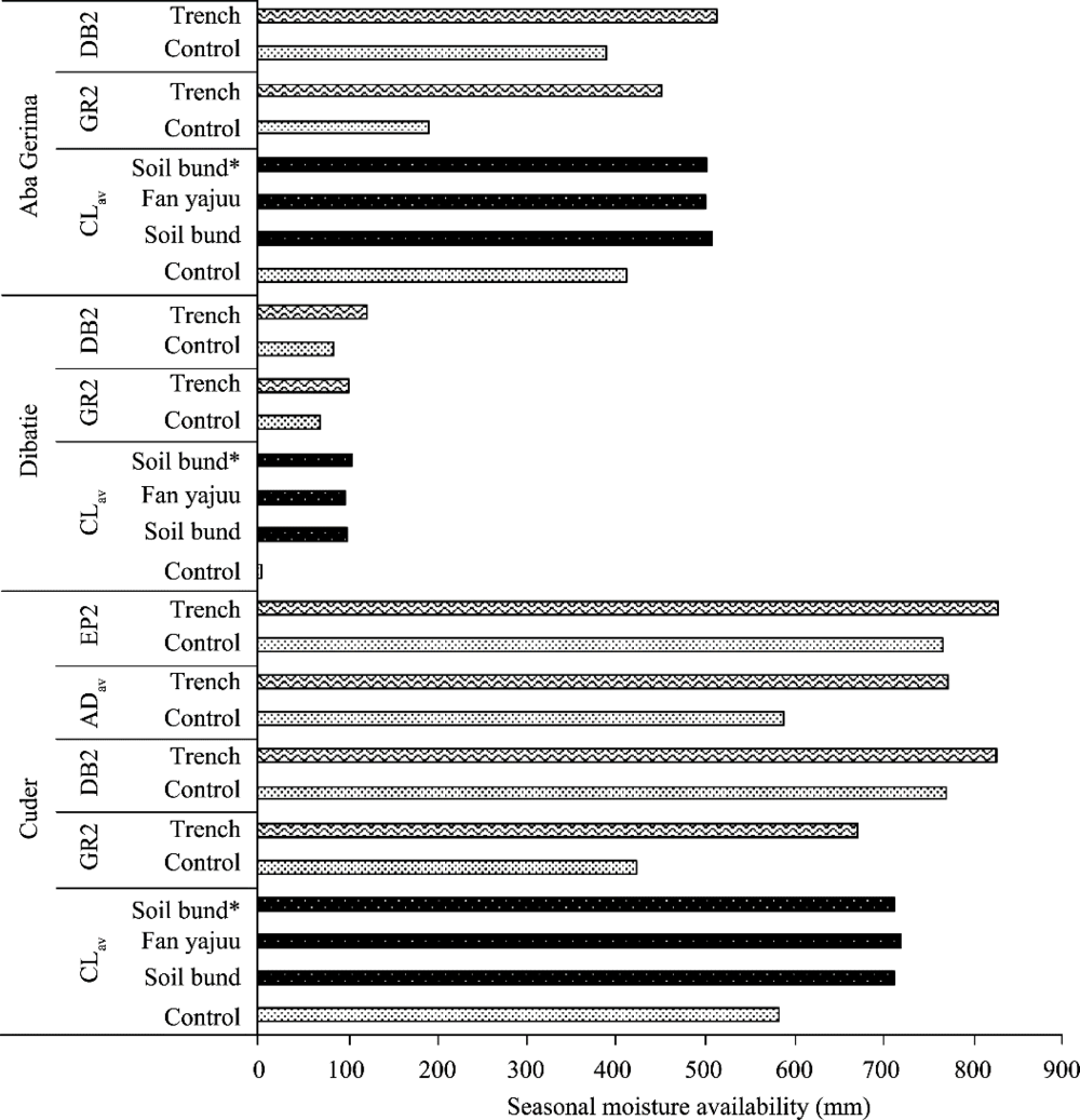
Fig. 6
Comparison of the effects of the different SWC practices on water availability during each month of the rainy season for the different agro-ecology systems. Clav, average for cultivated land in both slope classes (CL1 and CL2 in
Our results indicated that areas with higher rainfall (e.g., Guder) had higher potential soil moisture, and therefore a lower rainfall threshold to generate runoff. This decreased the conservation efficiency of the various soil and water conservation practices (Table 3). Consequently, the role of management practices was more important. It is more necessary to choose and design the optimal structure for these sites, i.e., where there is more runoff, there is more sediment transport capacity. Hence to control erosion and offsite transport of sediment, soil and water conservation planers need to focus on the safely disposal of the runoff to avoid risk of crop damage due to flooding or increase opportunities for sediment deposition from overland flow. This understanding helps to balance the soil erosion effect against the moisture retention/shedding effects of different measures.
Herweg and Ludi (1999)illustrated that runoff control requires a careful consideration of the design of soil and water conservation structures in relation to site characteristics. For example, in sub-humid or wetter areas with high rainfall, managers must prioritize both soil conservation and drainage of excess water. In addition, Nyssen et al. (2004) reported that in wet areas, investments in soil and water conservationmay not be profitable at the farm level, although there are positive social benefits fromcontrolling runoff and soil erosion at a regional level.
Although many of the methods discussed in this paper have been tried in the study area, they have not been widely adopted and have sometimes been dis-adopted where they were tried. To solve these problems, it will be necessary for the government and other stakeholders to increase knowledge transfer (extension) services to demonstrate the successful use of the techniques. In addition, the conservation structures all require ongoing maintenance. This agro-ecological classification and its related information assistsin utilizing the research and field experience of one place to other places of identicalsoil, climatic and topographic conditions.
In this study, we provided an overview of the hydrological dynamics and effectiveness of soil and water conservation practices to reduce runoff under the common agro-ecology systems in the Upper Blue Nile Basinof Ethiopia. These results can guide managers towards the optimal choice of soil and water conservation measures under specific site conditions. Our study revealed that the responses of runoff and runoff conservation efficiency to soil and water conservation practices were highly variable both within and between agro-ecology systems. This high variation could be attributed to a combination of several factors such asthe type of soil (permeability), land use types, soil water availability, the response of runoff to rainfall, and the prevailing climatic conditions (precipitation and potential evapotranspiration). These practices were highly effective in controlling runoff in the humid subtropical(Moist WeynaDega) and tropical hot humid(Moist Kolla) agro-ecology systems, with average runoff reductions of 42% and 41%, respectively. The moist subtropical region (Guder) had a higher potential soil moisture availability, but a lower rainfall threshold to generate runoff. From these findings, implementation of short trenches (humid subtropical) in grazing land maximized the efficiency in conserving runoff (55%) due to temporary water storage in the short trenches, followed by infiltration. In contrast, vegetated bunds would be most effective in cultivated land, and short trenches would be effective in the two plantation types. Our results demonstrate the importance of studying each combination of agro-ecologysystem, site, and climate to scientifically determine the optimal conservation measures for that combination instead of making blanket recommendations for all systems that are likely to provide suboptimal results for many combinations. This understanding and the present results will help managers to choose the most effective conservation measures based on field trials and to test whether they will be equally applicable at other locations with similar soil, climatic, and topographic conditions.
This research was supported by Grants-in-Aid for Scientific Research (25257417) from Japan Society for the Promotion of Science, Ministry of Education,Culture, Sports, Science and Technology, Japan.
The authors have declared that no competing interests exist.
| [1] |
DOI:10.1016/j.agwat.2012.10.026
URL
[CJCR: 1]
The results indicated that soil and water conservation had improved crop productivity. The average yields on terraced fields for teff, barley and maize were 0.9502t02ha 611 (control 0.49), 1.8602t02ha 611 (control 0.61), and 1.7302t02ha 611 (control 0.77), respectively. The net benefit was significantly higher on terraced fields, recording US$ 20.9 (US$ 61112 control) for teff, US$ 185 (US$ 6141 control) for barley and US$ 6134.5 (US$ 61101 control)02ha 611 02yr 611 for maize, respectively. The returns on family labour were 2.33, 1.01 and 0.73902US$02man-day 611 for barley, teff and maize grown on terraced plots compared to US$ 0.44, 0.27 and 0.1602man-day 611 for without, respectively. Using a discount rate of 10%, the average net present value (NPV) of barley production with terrace was found to be about US$ 1542 over a period of 50 years. In addition, the average financial internal rate of return (FIRR) was 301%. Other long-term impacts of terracing included farmers’ growing of maize on terraced fields as a result of water conservation. Currently, farmers also grow barley on terraced fields for two crop seasons per year unlike the experiences on farms without terraces. Household incomes and food security had improved and soil erosion drastically reduced. Many farmers had adopted terracing doubling the original area under the soil conservation pilot project and consequently improving environmental conservation in the watershed.
|
| [2] |
URL
[CJCR: 1]
ABSTRACT The study was conducted at Holeta Agricultural Research Center to assess runoff and soil losses and establish rainfall-runoff-soil loss relationships. Nine hydrologically isolated experimental runoff plots of 22 m length and 6 m width were installed on 10% slope and three dominant land uses (crops types) viz. faba bean (Vicia faba L. var. Degaga), field pea (Pisum sativum L. var. Tegegnech) and wheat (Triticum aestivum L. var. Kubsa). Daily values of rainfall, runoff and soil loss for three successive years (2005 to 2007) were recorded. The results showed that the average surface runoff generated from field pea, faba bean and wheat plots were 144.7 mm, 181.4 mm and 169.5 mm, respectively and the corresponding soil losses in the land use of the same order were 16.9, 29.9 and 20.29 Mg ha-1, respectively. Thus field pea was found to be effective in reducing runoff and soil loss. However, the actual runoff and soil losses recorded were still high in all cases which warrant the requirement of more effective soil and water conservation measures in the area. The runoff coefficient revealed that an average of 19 to 42% of the annual rainfall became runoff in the study areas under these land uses. The result of linear regression of rainfall-runoff-soil losses shows positive and strong relationships.
|
| [3] |
DOI:10.1002/ldr.2182
URL
[CJCR: 2]
ABSTRACT The effects of soil bunds on runoff, losses of soil and nutrients, and crop yield are rarely documented in the Central Highlands of Ethiopia. A field experiment was set up consisting of three treatments: (i) barley-cultivated land protected with graded soil bunds (Sb); (ii) fallow land (F); and (iii) barley-cultivated land without soil bund (Bc). For 365years (2007–2009), the effect of soil bunds on runoff, losses of soil and nutrients, and crop productivity was studied. Daily runoff and soil and nutrient losses were measured for each treatment using standard procedures while barley yield was recorded from the cultivated plots. The results showed that Sb brought about significant reduction in runoff and soil losses. Plots with Sb reduced the average annual runoff by 2865per cent and the average annual soil loss by 4765per cent. Consequently, Sb reduced losses of soil nutrients and organic carbon. However, the absolute losses were still high. This implies the need for supplementing Sb with biological and agronomic land management measures to further control soil erosion. Despite these positive impacts on soil quality, Sb do not increase crop yield. Calculated on a per-hectare basis, Sb even reduce crop yield by about 765per cent as compared with control plots, which is entirely explained by the reduction of the cultivable area by 8·665per cent due to the soil bunds. Suitable measures are needed to compensate the yield losses caused by the construction of soil bunds, which would convince farmers to construct these land management measures that have long-term beneficial effects on erosion control. Copyright 08 2012 John Wiley & Sons, Ltd.
|
| [4] |
URL
[CJCR: 1]
Page 1. AB.W 1 Crop evapotranspiration - Guidelines for computing crop water requirements -FAO Irrigation and drainage paper 56 By Richard G. Allen Utah State University Logan, Utah,USA Luis S. Pereira Instituto Superior de Agronomia Lisbon, Portugal
|
| [5] |
DOI:10.1016/j.ecohyd.2014.07.002
URL
[CJCR: 4]
Excessive runoff and soil erosion in the upper Blue Nile Basin poses a threat that has attracted the attention of the Ethiopian government because of the serious on-site effects in addition to downstream effects, such as the siltation of water harvesting structures and reservoirs. The objective of the study was to evaluate and recommend effective biophysical soil and water conservation measure(s) in the Debre Mewi watershed, about 3002km south of the Lake Tana. Six conservation measures were evaluated for their effects on runoff, soil loss, and forage yield using runoff plots. There was a significant difference between treatments for both runoff and soil loss. The four-year average annual soil loss in the different plots ranged from 26 to 7102t02ha 611 , and total runoff ranged from 180 to 30202mm, while annual rainfall varied between 85402mm in 2008 and 124702mm in 2011. Soil bund combined with elephant grass had the lowest runoff and soil loss as compared to the other treatments, whereas the untreated control plot had the highest for both parameters. As an additional benefit, 2.8 and 0.702t02ha 611 02year 611 of dried forage was obtained from elephant and local grasses, respectively. Furthermore, it was found that soil bund combined with Tephrosia increased soil organic matter by 13% compared to the control plot. Soil bund efficiency was significantly enhanced by combining them with biological measures and improved farmers’ perception of soil and water conservation measures.
|
| [6] |
DOI:10.1002/eco.170
URL
[CJCR: 1]
Abstract Understanding the basic runoff processes in the Ethiopian highlands is vital for effective management and utilization of water resources and soil conservation planning. An important question for judging the effectiveness of conservation practices is whether runoff is affected by ecology (mainly type of crop) or topography (landscape). A study was conducted in the 113 ha watershed of Maybar, located in the highlands. This watershed has long-term records of rainfall and discharge. To study runoff processes, piezometers were installed in eight transects up and down the slope. In addition, infiltration rates (measured earlier) were compared with rainfall intensities. The results show that the amount of runoff at the test plots was greater for cropland located on mild to intermediate slopes than for grasslands and woodlands on the steeper slopes. Water tables were closer to the surface on cropland for the mild to intermediate slopes than on grasslands and in woodlands for the steeper slopes. Thus, although water table depths and plot runoff were inconclusive on the type of runoff mechanisms, infiltration rates that were generally in excess of the rainfall rates imply that any ecological effect on the amount of surface runoff is small. This is because water infiltration is independent of crop type. Only in cases where the soil was saturated did runoff occur. Piezometer readings show that saturation occurs at the foot of the steep slopes and, therefore, it demonstrates that topographic processes are dominant. Ecology becomes important when infiltration rates are in the same order as the rainfall intensities. Copyright 2010 John Wiley & Sons, Ltd.
|
| [7] |
|
| [8] |
DOI:10.1016/S0341-8162(98)00092-7
URL
[CJCR: 1]
Measurements of runoff and infiltration were made at five spatial scales, terracette (<1 m), hummock (10--20 m), part-slope (1000--2000 m), slope (1 ha) and catchment (50 ha), on a shrubland and an open forest site. The study was aimed at understanding the relationships between runoff production, vegetation patterns and microtopography at different spatial scales within a sparsely vegetated, semiarid area. The results of runoff monitoring and rainfall simulation experiments showed that runoff did not occur at the slope scale. It was buffered at the terracette level by nonuniform infiltration at the rims of terracettes and at the hummock scale by rapid infiltration under oak shrubs and trees. Slope and catchment runoff were not connected to runoff at these fine scales. The field evidence is discussed within the context of hierarchy theory, and the implications for management of these shrublands are related to maintaining both the vegetation mosaic and runoff on these slopes. 1998 Elsevier Science B.V. All rights reserved.
|
| [9] |
DOI:10.2136/sssaj1997.03615995006100040018x
URL
[CJCR: 1]
The removal of vegetation is the main cause of soil degradation in semiarid areas. We hypothesized that the changes in soil properties induced by vegetation removal modified the runoff and soil erosion response in a semiarid area of Spain. To test this, two plots (15 by 5 m) were installed on a 23% slope on a Lithic Haploxeroll. Vegetation was removed by clipping from one of the plots (Plot D) and the changes in surface runoff and soil loss were compared with an undisturbed control plot (Plot N) from 1989 to 1993. Total runoff was significantly greater in Plot D (48.8 mm) than in Plot N (34.9 mm). Runoff ratios between the disturbed and natural plots increased with time from 1.4:1 in 1990 to 2.5:1 in 1993. Vegetation removal increased the soil losses in Plot D (150.2 g m-2) by 127% compared with those in Plot N (66.3 g m-2). The annual soil loss ratio between the disturbed and natural plots increased from 1.6:1 in 1989 to 4.2:1 in 1993. The observed increase in surface runoff and soil loss was attributed to a progressive deterioration of soil physical properties in Plot D. Bulk density increased by 8.4% (from 1.55 to 1.68 Mg m-3) and a reduction of total organic carbon (from 4.0 to 2.6%) and the percentage of stable aggregates (from 81.6 to 56.3%) were observed. There was no evidence of vegetation recovery, suggesting that reduced vegetal cover might lead to irreversible soil degradation in semiarid areas
|
| [10] |
DOI:10.1515/johh-2015-0021
URL
[CJCR: 1]
In response to the continually increasing sediment concentrations in rivers and lakes, the Ethiopian government is leading an effort where farmers are installing soil and water conservation measures to increase infiltration and reduce erosion. This paper reports on findings from a four year study in the 95 ha Debre Mawi watershed where under the government led conservation works, mainly terraces with infiltration furrows were installed halfway in the period of observation. The results show that runoff volume decreased significantly after installation of the soil and water conservation practices but sediment concentration decreased only marginally. Sediment loads were reduced mainly because of the reduced runoff. Infiltration furrows were effective on the hillsides where rain water could infiltrate, but on the flat bottom lands that become saturated with the progress of the monsoon rain, infiltration was restricted and conservation practices became conduits for carrying excess rainfall. This caused the initiation of gullies in several occasions in the saturated bottomlands. Sediment concentration at the outlet barely decreased due to entrainment of loose soil from unstable banks of gullies in the periodically saturated bottom areas. Since most uphill drainage were already half filled up with sediments after two years, long term benefits of reducing runoff can only be sustained with continuous maintenance of uphill infiltration furrows.
|
| [11] |
DOI:10.1016/j.jhydrol.2006.05.015
URL
[CJCR: 3]
Daily runoff depths from 28 plots (5 m 2 m) recorded during a 2-year period in the semi-arid to subhumid highlands of Tigray were analyzed to study the effect of vegetation restoration in exclosures and to identify other factors influencing runoff production. Plots are distributed over three study sites and located in different land use types and on different combinations of soil type, vegetation cover and slope gradient. Runoff was found to be significantly reduced when a degraded area is allowed to rehabilitate after closure. Runoff depth is significantly correlated with event variables such as rain depth, rainfall intensity, storm duration and soil moisture content. Total vegetation cover is the most important plot variable explaining about 80% of the variation in runoff coefficients through an exponential decay function. Also the runoff generating rainfall threshold has a positive correlation with total vegetation cover. Runoff was found to be negligible when the vegetation cover exceeds 65%. Other important variables affecting runoff production in the study sites are soil organic matter, soil bulk density, litter cover and slope gradient.
|
| [12] |
DOI:10.1016/S0341-8162(00)00124-7
URL
[CJCR: 1]
In mountainous areas, runoff and soil erosion are closely linked to soil surface features, particularly stoniness. Depending on the size of rock fragments (gravel, pebbles, stones and/or blocks) and especially the way they are integrated into the soil matrix, they may facilitate or hinder infiltration and promote soil losses. The present study examines the role of different soil surface features and their influence on runoff formation and on soil erosion in an area seriously affected by overgrazing. Based on measurements made on hillslopes for 2 years at the plot scale, the results show that grass cover, pebbles and sand content increase runoff and erosion. Inversely, slope value, tree cover percentage, structural stability and organic matter content are negatively correlated with runoff and soil losses. It is shown that the correlations can be explained by the major role played by the surface features on hydrologic behaviour of the hillslopes. Two main surface features were identified and hydraulically characterised, namely: (i) crusted surfaces with embedded gravel widespread on gentle slopes which induce high runoff and erosion rates; and (ii) stony surfaces, where free pebbles and blocks protect the top soil against raindrops and overland flow kinetic energy and lead to reduce runoff and soil losses.
|
| [13] |
|
| [14] |
|
| [15] |
DOI:10.1002/hyp.11378
URL
[CJCR: 1]
Abstract Soil erosion by water is one of the main environmental concerns in the drought-prone Eastern Africa region. Understanding factors such as rainfall and erosivity is therefore of utmost importance for soil erosion risk assessment and soil and water conservation planning. In this study, we evaluated the spatial distribution and temporal trends of rainfall and erosivity for the Eastern Africa region during the period 1981–2016. The precipitation concentration index, seasonality index, and modified Fournier index have been analysed using 5×5-km resolution multisource rainfall product (Climate Hazards Group InfraRed Precipitation with Stations). The mean annual rainfall of the region was 810mm ranging from less than 300mm in the lowland areas to over 1,200mm in the highlands being influenced by orography of the Eastern Africa region. The precipitation concentration index and seasonality index revealed a spatial pattern of rainfall seasonality dependent on latitude, with a more pronounced seasonality as we go far from the equator. The modified Fournier index showed high spatial variability with about 55% of the region subject to high to very high rainfall erosivity. The mean annual R-factor in the study region was calculated at 3,246±1,895MJ mm ha 611 h 611 yr 611 , implying a potentially high water erosion risk in the region. Moreover, both increasing and decreasing trends of annual rainfall and erosivity were observed but spatial variability of these trends was high. This study offers useful information for better soil erosion prediction as well as can support policy development to achieve sustainable regional environmental planning and management of soil and water resources.
|
| [16] |
DOI:10.1007/s10113-017-1103-y
URL
[CJCR: 1]
Climate variability and human activities are two major drivers influencing changes in streamflow response of a watershed, and thus assessing their relative effect is essential for developing sustainab
|
| [17] |
DOI:10.1016/j.jhydrol.2009.07.066
URL
[CJCR: 2]
Concentration of sediment-associated nutrient losses decreased with increasing sediment yield, supposedly related to the important nutrient dissolution effect of high runoff volumes. Rainfalls with low amount and intensity are important for selective removal of nutrient-rich sediments. Annually, on average, nutrient and OC losses varied between 14.4 and 263.402kg02ha 611 02y 611 for OC, 2.1–32.802kg02ha 611 02y 611 for N, 0.02–0.202kg02ha 611 02y 611 for available P and 0.35–5.2502kg02ha 611 02y 611 for available K, with the lowest values in all cases on exclosures and highest on cultivated land. The present study demonstrates the effectiveness of exclosures and plantation in controlling runoff, sediment and sediment-associated nutrient losses on steep degrading lands of the region.
|
| [18] |
DOI:10.1177/0309133315598725
URL
[CJCR: 2]
This paper reviews Ethiopia experience and research progress in past soil and water conservation (SWC) efforts and suggests possible solutions for improvement. Although indigenous SWC techniques date back to 400 BC, institutionalized SWC activity in Ethiopia became significant only after the 1970s. At least six national SWC related programs have been initiated since the 1970s and their focus over time has shifted from food relief to land conservation and then to livelihoods. The overall current soil erosion rates are highly variable and large by international standards, and sheet, rill, and gully erosion are the dominant processes. The influence of human activities on the landscape has traditionally been deleterious, but this trend seems to have recently reversed in some parts of the country following the engagement of the communities in land management. The efficiency of SWC measures show mixed results that are influenced by the type of measures and the agro-ecology under which they were implemented; in general, the relative performance of the interventions is better in the drylands as compared to humid areas. Methodological limitations also occur when addressing the economic aspects related to benefits of ecosystem services and other externalities. Although farmers have shown an increased understanding of the soil erosion problem, SWC efforts face a host of barriers related to limited access to capital, limited benefits, land tenure insecurity, limited technology choices and technical support, and poor community participation. In general SWC research in Ethiopia is fragmented and not comprehensive, mainly because of a lack of participatory research, field observations, and adoptable methods to evaluate impacts. A potentially feasible approach to expand and sustain SWC programs is to attract benefits from global carbon markets. Moreover, a dedicated institution responsible for overseeing the research xtension linkage of SWC interventions of the country should be established.
|
| [19] |
DOI:10.1007/s10113-015-0813-2
URL
[CJCR: 2]
In the drylands of the Upper Blue Nile basin, high climate variability and land degradation are rampant. To enhance adaptive capacity in the region, various soil and water conservation interventions have been implemented. Moreover, water resources development schemes such as the Grand Ethiopian Renaissance Dam should be implemented by 2025. We modeled the effects of these interventions on surface runoff in the basin for both current and future (2025) basin conditions, using the runoff coefficient method in a spatially explicit approach. Under current conditions, we observed high spatial variability of mean annual runoff. The northeastern Blue Nile-1 sub-basin produces the highest mean annual runoff (39102mm or 1002×0210 9 02m 3 ), whereas the northwestern Blue Nile-2 sub-basin produces the lowest mean annual runoff (17802mm or 0.202×0210 9 02m 3 ). The basin generates a total annual runoff volume of 47.702×0210 9 02m 3 , of which about 5402% comes from cultivated land. The strong association between land use and topography masked the direct effect of rainfall on runoff. By 2025, total annual runoff yield could decrease by up to 3802% if appropriate basin-wide soil and water conservation interventions and the Grand Ethiopian Renaissance Dam are implemented. However, the full effects of most physical structures will only last for 1 or 202years without regular maintenance. The improved understanding of the dynamics of the Upper Blue Nile basin’s hydrology provided by the present study will help planners to design appropriate management scenarios. Developing the basin’s database remains important for a holistic understanding of the impacts of future development interventions.
|
| [20] |
DOI:10.1016/j.scitotenv.2016.09.019
PMID:27623531
URL
[CJCR: 2]
In the drought-prone Upper Blue Nile River (UBNR) basin of Ethiopia, soil erosion by water results in significant consequences that also affect downstream countries. However, there have been limited comprehensive studies of this and other basins with diverse agroecologies. We analyzed the variability of gross soil loss and sediment yield rates under present and expected future conditions using a newly devised methodological framework. The results showed that the basin generates an average soil loss rate of 27.502t02ha 61021 02yr 61021 and a gross soil loss of ca. 47302Mt02yr 61021 , of which, at least 10% comes from gully erosion and 26.7% leaves Ethiopia. In a factor analysis, variation in agroecology (average factor score02=021.32) and slope (1.28) were the two factors most responsible for this high spatial variability. About 39% of the basin area is experiencing severe to very severe (>023002t02ha 61021 02yr 61021 ) soil erosion risk, which is strongly linked to population density. Severe or very severe soil erosion affects the largest proportion of land in three subbasins of the UBNR basin: Blue Nile 4 (53.9%), Blue Nile 3 (45.1%), and Jema Shet (42.5%). If appropriate soil and water conservation practices targeted ca. 77.3% of the area with moderate to severe erosion (>021502t02ha 61021 02yr 61021 ), the total soil loss from the basin could be reduced by ca. 52%. Our methodological framework identified the potential risk for soil erosion in large-scale zones, and with a more sophisticated model and input data of higher spatial and temporal resolution, results could be specified locally within these risk zones. Accurate assessment of soil erosion in the UBNR basin would support sustainable use of the basin's land resources and possibly open up prospects for cooperation in the Eastern Nile region.
|
| [21] |
DOI:10.13031/2013.26773
URL
[CJCR: 2]
MEASURED lysimeter evapotranspiration of Alta fescue grass (a cool season grass) is taken as an index of reference crop evapotranspiration (ETo). An equation is presented that estimates ETo from measured values of daily or mean values of maximum and minimum temperature. This equation is compared with various other methods for estimating ETo. The equation was developed using eight years of daily lysimeter data from Davis, California and used to estimate values of ETo for other locations. Comparisons with other methods with measured cool season grass evapotranspiration at Aspendale, Australia; Lompoc, California; and Seabrook, New Jersey; with lysimeter data from Damin, Haiti; and with the modified Penman for various locations in Bangladesh indicated that the method usually does not require local calibration and that the estimated values are probably as reliable and useable as those from the other estimating methods used for comparison. Considering the scarcity of complete and reliable climatic data for estimating crop water requirements in developing countries, this proposed method can do much to improve irrigation planning design and scheduling in the developing countries.
|
| [22] |
DOI:10.1016/S0341-8162(99)00004-1
URL
[CJCR: 5]
This paper investigates the performance of selected soil and water conservation measures in the highlands of Ethiopia and Eritrea, namely Fanya Juu , soil/stone bund, grass strips and double ditches. The impact of these techniques on runoff, soil loss, crop yield and biomass production is measured at on-farm experimental sites in seven research sites under different agro-ecological conditions. On one hand, most measures brought about a considerable reduction in soil loss and runoff. The latter, however, increases the waterlogging hazard, particularly in sub-humid environments. On the other hand, crop yield and biomass production did not increase, as it would have been necessary to compensate for the high costs of soil conservation. Thus, the measures tested only partially fulfil their requirements. To enhance their adaptability to local conditions, they must be supplemented with biological and agronomic measures that help improve production.
|
| [23] |
|
| [24] |
|
| [25] |
|
| [26] |
|
| [27] |
DOI:10.1016/S0308-521X(96)00015-7
URL
Climate models indicate that increasing atmospheric concentrations of carbon dioxide and other greenhouse gases could alter climate globally. The EPIC (Erosion/Productivity Impact Calculator) model was used to examine the sensitivity of soil erosion (wind, water) and soil organic carbon (SOC) (15 cm and 1 m depth) across the US corn belt to changes in temperature (+ 2°C), precipitation (±10%, ±20%), wind speed (±10%, ±20%), and atmospheric CO 2 concentration (350, 625 ppmv). One-hundred-year simulations were run for each of 100 sites under 36 climate/CO 2 regimes. The 100-year regionally aggregated mean water erosion rates increased linearly with precipitation, whereas the wind erosion rates decreased and total erosion rates increased non-linearly. Increasing temperature by 2°C (with CO 2 and mean wind speed held constant) decreased water erosion by 3–5%, whereas wind erosion increased by 15–18%. Total erosion increased with increased temperature. Increasing CO 2 from 350 to 625 ppmv (with temperature increased by 2°C and mean wind speed held constant) had no effect on water erosion, despite increases in annual total and peak runoff; this was attributed to increased vegetation cover. Wind erosion decreased by 4–11% under increased CO 2 . Wind erosion was very sensitive to mean wind speed, increasing four-fold and decreasing 10-fold for a 20% increase or decrease in mean wind speed, respectively. This was attributed to a threshold effect. SOC to 1 m decreased 4·8 Mg-C ha 611 from an initial value of 18·1 Mg-C ha 611 during the 100-year baseline simulation. About 50% of this loss (2·3 Mg-C ha 611 ) was due to transport off-site by soil erosion. SOC in the top 15 cm decreased 0·8 Mg-C ha 611 from an initial value of 4·9 Mg-C ha 611 . Increased temperature and precipitation accelerated these losses of SOC, whereas increased CO 2 slowed the losses.
|
| [28] |
DOI:10.1080/14735903.2012.751701
URL
[CJCR: 1]
This article analyses roles of social and extension networks in adoption of resource-conserving practices among Ethiopian farmers. We gathered data from 297 randomly sampled households on their agricultural practices, social networks, access to the extension, and geographical location. After examining general determinants of practising resource-conserving agriculture, we employ a two-stage regression with full-maximum likelihood correction for selection bias to establish the roles of general social networks and external professionals in acceptance of conservation techniques. In accordance with previous research, probit regression in the first stage shows that the access to extension increases with farmers090005 wealth and the size of their personal networks, and decreases with the distance of their households from village centres. However, after accounting for this unequal access to extension, the second-stage linear regression shows that regardless of education, wealth or geographical location, those whose religion and ethnicity match with their agent, report learning more about conservation from extension sources. Furthermore, farmers who are socially well connected within the community tend to be less receptive to agents090005 recommendations regarding resource conservation. Dissemination policy of conservation agriculture should consider the ethnic and religious affinity between farmers and their extension agents. It also needs to pay more attention to socially and geographically isolated individuals.
|
| [29] |
|
| [30] |
|
| [31] |
DOI:10.1002/ldr.2647
[CJCR: 3]
Abstract Soil erosion is a significant problem in the Ethiopian highlands. The objective of this study was to investigate how farmers perceive the severity of soil erosion in the Upper Blue Nile Basin. The study is based on a detailed survey of 300 households and 1010 plots owned by these households in three watersheds. Descriptive statistics and a partial proportional odds model were applied to analyze factors that affected farmers’ perceived soil erosion severity at the plot-level. Results showed that variables such as plot distance from the residence, plot shape and position on hill slopes affected farmers’ perceptions of soil erosion severity, as well as the amount of rainfall during the growing season. Farmer interaction with extension service agents also affected farmers’ perception of soil erosion severity. Despite their expected importance, education and number of livestock owned had no effect on the farmers’ perception of soil erosion. The results indicate that farmers’ perceptions generally match empirical and theoretical findings on soil erosion determinants; thus, farmers should be considered as important partners not only to counter soil erosion, but also to obtain local expertise on soil erosion severity and restoration of degraded land.
|
| [32] |
DOI:10.1002/1099-145X(200005/06)11:33.0.CO;2-Y
URL
[CJCR: 1]
A traditional technique, the daget technique for soil and water conservation in northern Ethiopia, is described and its evolution and reasons for partial destruction are outlined. Dagets are lynchets 0.3-3.0 m high, about 2 m wide, and partly covered with grasses. Farmers established these earthen bunds at the lower plot limit to reduce runoff velocity, allow water to infiltrate and trap sedime...
|
| [33] |
DOI:10.1016/S0012-8252(03)00078-3
URL
[CJCR: 1]
The present land degradation in the Ethiopian highlands has a particular origin, which includes poverty and lack of agricultural intensification. Causes of these are to be found in the nature of past and present regional social relations as well as in international unequal development. This review strengthens our belief that, under improved socio-economic conditions, land husbandry can be made sustainable, leading to a reversal of the present desertification and land degradation of the Ethiopian highlands.
|
| [34] |
URL
[CJCR: 1]
The soil and water conservation is one of the most important components of integrated watershed program. Earlier in soil and water conservation programs, e$orts were concentrated on construction of various types of bunds across the slope. This helped in controlling erosion and reducing soil loss rather than increasing crop yields through additional moisture conservation. Current emphasis is more on improving moisture through various %eld- and community-based moisture conservation practices. This paper discusses the key %ndings from the various watershed programs and research stations on %eld- and community-based soil and water conservation interventions that were found promising for improving productivity and reducing land degradation in di$erent regions of India.
|
| [35] |
DOI:10.1080/02626668809491261
URL
[CJCR: 1]
The distinctive features of arid and semiarid regions affect rainfall-runoff modelling on both a discrete event basis and a continuous basis. The general characteristics of arid zone hydrological processes and the problems that they present in runoff modelling are discussed. Both sloping lands with integrated stream networks and flatlands with repetitive micro-hydrology are considered. The wide diversity in some characteristics may require different parameter values and possibly different approaches in different regions. Lack of observed data provides the major problem for runoff modelling in arid regions. Some comments are given on appropriate approaches to modelling for sloping regions.
|
| [36] |
DOI:10.1016/j.jag.2012.07.009
URL
[CJCR: 1]
In this study we aim to assess the diurnal cycle of rainfall across the Upper Blue Nile (UBN) basin using satellite observations from Tropical Rainfall Measuring Mission (TRMM). Seven years (2002鈥2008) of Precipitation Radar (PR) and TRMM Microwave Imager (TMI) data are used and analyses are based on GIS operations and simple statistical techniques. Observations from PR and TMI reveal that over most parts of the basin area, the rainfall occurrence and conditional mean rain rate are highest between mid- and late-afternoon (15:00鈥18:00 LST). Exceptions to this are the south-west and south-eastern parts of the basin area and the Lake Tana basin where midnight and early morning maxima are observed. Along the Blue Nile River gorge the rainfall occurrence and the conditional mean rain rate are highest during the night (20:00 23:00 LST). Orographic effects by large scale variation of topography, elevation and the presence of the UBN river gorge were assessed taking two transects across the basin. Along transects from north to south and from east to west results indicate increased rainfall with increase of elevation whereas areas on the windward side of the high mountain ranges receive higher amount of rainfall than areas on the leeward side. As such, mountain ranges and elevation affect the rainfall distribution resulting in rain shadow effect in the north-eastern parts of Choke-mountain and the ridges in the north-east of the basin. Moreover, a direct relation between rainfall occurrence and elevation is observed specifically for 17:00鈥18:00 LST. Further, results indicate that the rainfall distribution in the deeply incised and wide river gorge is affected with relatively low rainfall occurrence and low mean rainfall rates in the gorge areas. Seasonal mean rainfall depth is highest in the south-west area and central highlands of the basin while areas in the north, north-east and along the Blue Nile gorge receive the least amount of rainfall. Statistical results of this work show that the diurnal cycle of rainfall occurrence from TRMM estimates show significant correlation with the ground observations at 95% confidence level. In the UBN basin, the PR conditional mean rain rate estimates are closer to the ground observations than the TMI. Analysis on mean wet season rainfall amount indicates that PR generally underestimates and TMI overestimates the ground observed rainfall.
|
| [37] |
DOI:10.1016/j.iswcr.2016.07.002
URL
[CJCR: 1]
Growing of tea on sloping land without any soil and water conservation measures causes enormous soil loss especially in the initial years. For sound soil and water conservation planning, there is a need to evaluate the various conservation measures as related to the amount of expected runoff and soil erosion. In this context, a field study was conducted in the farmer's field in Nilgiris of South India, for evaluating the impact of farming methods on soil and water conservation efficiency under new tea plantation. One year old B-6 tea clones were planted at double hedge spacing (13502cm×7502cm×7502cm) in two slopes (8–12% and 30–35%) with treatments viz ., contour staggered trenches (CST), vegetative barrier (VB), CST alternate with VB, CST with cover crop of beans and farmers’ practice of plantation. Minimum runoff (14.6%) was observed from CST with cover crop of beans followed by CST (15.4%) under 8–12% slope range with exactly similar trend in runoff from the plots under 30–35% slope. Contrary to runoff, minimum soil loss was observed from CST (4.9 and 6.902t02ha 611 02yr 611 ) followed by CST with cover crop of beans (5.3 and 7.302t02ha 611 02yr 611 ) under 8–12% and 30–35% respectively. Implementation CST and CST with cover crop of beans are resulted in better soil moisture under both the slope ranges in comparison to remaining measures as well as farmers’ practice of plantation. Therefore, either CST alone or in combination with cover crop of beans are recommended for soil and water conservation under new tea plantation in the hill slopes.
|
| [38] |
URL
[CJCR: 2]
This analysis utilizes recent hydrological and meteorological data collected from the Mizewa watershed in order to better understand the physical impact of SLWM investments. The effectiveness of the simulated conservation practices (terraces, bunds, and residue management) are evaluated using the Soil and Water Assessment Tool (SWAT) model taking into account investment decisions on different terrain types.
|
| [39] |
|
| [40] |
DOI:10.1080/02723646.2017.1302869
URL
[CJCR: 5]
Abstract Different soil and water conservation (SWC) practices have been implemented in many drought-prone parts of Ethiopia since the 1980s. We assessed the effect of SWC practices on runoff response and experimentally derived and tested the validity of the runoff curve number (CN) model parameter for the tropical humid highland climate of the Kasiry watershed in northwestern Ethiopia. We recorded daily rainfall and runoff depth from 18 runoff plots (30 m long 脳 6 m wide) representing the five main land-use types with various SWC practices and two slope classes (gentle and steep). CN values were derived using the lognormal geometric mean CN procedure. Runoff was significantly less from plots with SWC measures, with average reductions of 44 and 65% observed in cultivated and non-agricultural lands, respectively. Runoff on plots representing non-agricultural land was relatively accurately predicted with the derived CN method, but predictions were less accurate for plots treated with a SWC practice. We conclude that predicting the effect of SWC practices on runoff requires parameterization with separate sets of CN value for each SWC practice.
|
| [41] |
DOI:10.1007/s10806-004-1470-5
URL
[CJCR: 1]
Soil degradation is one of the most serious environmental problems in Ethiopia. The Ethiopian highlands have been experiencing declining soil fertility and severe soil erosion due to intensive farming on steep and fragile lands and other factors attributed to population pressure. This study used a binomial logit model to identify factors that determine adoption of physical soil conservation measures, namely soil bunds and fanyajuu in Southern Ethiopia, Gununo area. Data collected from a random sample of 120 heads of households were used to estimate the binomial logit model. The results show that adoption of soil conservation measures depends on a host of factors.Ab out 78 percent of the sample cases were correctly predicted using the model.
|
| [42] |
DOI:10.1109/OCEANS-Bergen.2013.6607965
URL
[CJCR: 1]
Land degradation and recurrent drought are the major threats to rain-fed agriculture in the semi-arid Ethiopian highlands. Water harvesting has become a priority in the Tigray region since 1990. However, the success of water harvesting in reservoirs is limited due to reduced inflow. The aim of this study was to investigate the effects of typical land-use types, slope gradients, and different soil and water conservation (SWC) structures on runoff and soil loss at the runoff-plot scale. Six runoff measuring sites, corresponding to three slope gradients, were established for cropland (cultivated land for annual crop production) and rangeland (heavily grazed land on hillslopes with high rock-fragment cover) at Mayleba catchment in Tigray, Ethiopia. SWC structures tested were stone bunds, trenches, and stone bunds with trenches, in addition to control plots. In total, 21 large runoff plots (with lengths of 60 to 100 m) were monitored daily for runoff production and soil loss during the main rainy season (July-September) in 2010. The results show that the seasonal runoff coefficient (RCs) representing the fraction of rainfall measured as runoff was much higher for rangeland (0.38 < RCs < 0.50) compared to that for cropland (0.11 < RCS < 0.15). Seasonal soil loss (SLs) values were five to six times larger on rangeland (28.6 < SLs < 50.0 ton ha-1) compared to that for cropland (4.6 < SLs < 11.4 ton ha-1). Stone bunds with trenches were the most effective SWC structures in reducing runoff and soil loss. With the same SWC structures installed, RCs and SLs for both rangeland and cropland tend to decrease with increasing slope gradient mainly due to a corresponding increase in rock-fragment cover. The effects of SWC structures on runoff production and soil loss are considerable; hence, it is crucial to consider these effects for optimal design of water-harvesting schemes such as micro-dams that collect and store surface runoff for irrigation development in the Ethiopian highlands.
|
| [43] |
DOI:10.3389/feart.2015.00049
URL
[CJCR: 1]
Despite millions of dollars invested in soil and water conservation practices in the (sub) humid Ethiopian highlands and billions of hours of food-for-work farm labor, sediment concentration in rivers is increasing. This paper reports on the research to reverse the current trend. Based on the understanding of the hydrology of highlands, we provide evidence on sources of surface runoff and sediment and on mechanisms that govern the erosion processes and approaches and how they affect soil and water conservation practices. We suggest that priority in landscape interventions should be given to re-vegetation of the degraded areas so as to reduce the sediment concentration contributions originating from these areas. Additionally, efforts should be directed to gully rehabilitation in the saturated bottom landscape that may consist of vegetating shallow gullies and stabilizing head cuts of deeper gullies Finally, rehabilitation efforts should be directed to increase the rain water infiltration in the upland areas through the hard pan layer by connecting the land surface to the original deep flow paths that exist below about 60 cm. It will reduce the direct runoff during the rainy season and increase baseflow during the dry season.
|
