

 ,
, The rapid desertification of grasslands in Inner Mongolia of China poses a significant ecological threaten to northern China. The combined effects of anthropogenic disturbances (e.g., overgrazing) and biophysical processes (e.g., soil erosion) have led to vegetation degradation and the consequent acceleration of regional desertification. Thus, mitigating the accelerated wind erosion, a cause and effect of grassland desertification, is critical for the sustainable management of grasslands. Here, a combination of mobile wind tunnel experiments and wind erosion model was used to explore the effects of different levels of vegetation coverage, soil moisture and wind speed on wind erosion at different positions of a slope inside an enclosed desert steppe in the Xilamuren grassland of Inner Mongolia. The results indicated a significant spatial difference in wind erosion intensities depending on the vegetation coverage, with a strong decreasing trend from the top to the base of the slope. Increasing vegetation coverage resulted in a rapid decrease in wind erosion as explained by a power function correlation. Vegetation coverage was found to be a dominant control on wind erosion by increasing the surface roughness and by lowering the threshold wind velocity for erosion. The critical vegetation coverage required for effectively controlling wind erosion was found to be higher than 60%. Further, the wind erosion rates were negatively correlated with surface soil moisture and the mass flux in aeolian sand transport increased with increasing wind speed. We developed a mathematical model of wind erosion based on the results of an orthogonal array design. The results from the model simulation indicated that the standardized regression coefficients of the main effects of the three factors (vegetation coverage, soil moisture and wind speed) on the mass flux in aeolian sand transport were in the following order: wind speed>vegetation coverage>soil moisture. These three factors had different levels of interactive effects on the mass flux in aeolian sand transport. Our results will improve the understanding of the interactive effects of wind speed, vegetation coverage and soil moisture in controlling wind erosion in desert steppes, and will be helpful for the design of desertification control programs in future.
Wind erosion, the wind-forced movement of surface soil particles (Řeháček et al., 2017), is a continuous and dynamic natural geomorphic process. Anthropogenic and natural disturbances can greatly accelerate wind erosion, resulting in the loss of soil nutrients and the decline of land productivity, thus threatening human survival (Adhikari and Hartemink, 2016; Yang and Lu, 2016). Global accelerated soil erosion by wind is a serious environmental issue affecting approximately 9×10⁸ people from 100 countries and territories (Webb et al., 2006). The land area vulnerable to wind erosion accounts for nearly a quarter of the total global land area (Fernandez-Bernal and de la Rosa, 2009). Further, accelerated wind erosion is regarded as a cause and effect of desertification in arid and semi-arid regions (Ma et al., 2017) and land degradation in some sub-humid regions (Wang, 2010). Research on wind erosion has been done by scholars at home and abroad. Factors that influence wind erosion can be summed up as vegetation status/coverage (Mendez and Buschiazzo, 2015), soil conditions (Bu et al., 2015; Bergametti et al., 2016) and wind speed (Kang et al., 2012; He et al., 2013).
In China, the total area susceptible to wind erosion exceeds half of the total land area (Wang, 2010; Zhang et al., 2017), primarily affecting the arid and semi-arid areas (Wang, 2010). The grassland ecosystem is the largest terrestrial ecosystem in China (41% of the total land area), especially in Inner Mongolia Autonomous Region. Its normal function plays a pivotal role in maintaining regional and global ecosystem dynamics. However, more than 90% of the grassland in China is currently undergoing various levels of degradation , causing a significant decline in land productivity. The livestock carrying capacity of natural grassland in desertified areas of Inner Mongolia in the 2010s is only 75% of that in the 1950s. In severe cases, rapid desertification resulted from accelerated wind erosion could result in a complete loss of productivity for some grasslands, thereby seriously affecting ecosystem health (Zobeck and van Pelt, 2006; Lozano et al., 2013; Borrelli et al., 2016, 2017). Studies focusing on the ecological effect of erosion control structures such as windbreaks (Yan et al., 2011) concluded that surface roughness increased with vegetation coverage increasing (in the form of a power function), while wind erosion rate increased with decreasing vegetation coverage (in the form of an exponential function). Mendez and Buschiazzo (2015) demonstrated that wind erosion could be effectively controlled even by a very limited vegetation coverage. The porosity of vegetation was found to be a major factor determining the sediment capturing capacity, and the threshold porosity value for maximum dust capturing efficiency was about 20% (Raupach et al., 2001; Zhao et al., 2017).
Although studies on the relationship between vegetation and soil erosion had been done, most of these studies are based on wind tunnel simulations which often focused on coastal and inland hyper arid desert areas but rarely on desert steppes in semi-arid regions (Zhang et al., 2017). To address this knowledge gap, we explored the effects of different levels of vegetation coverage, soil moisture and wind speed on wind erosion of different slope positions in an enclosed desert steppe of Xilamuren grassland, Inner Mongolia of China. Further, we developed a multi-factor mathematical model of wind erosion and analyzed the main affecting factors and their interactions. Collectively, our goals were (1) to discern the natural pattern of wind erosion, providing a theoretical support for soil erosion prevention and ecological recovery in the region to prevent surface wind erosion hazards, and (2) to design and evaluate the effectiveness of wind erosion control practices in the desert steppe in Inner Mongolia of China, as well as in the other similar desert steppe regions in the world.
This study was conducted in the Xilamuren grassland of the southeastern Darhan Muminggan Joint Banner, Inner Mongolia, China. The study area is located in the transition zone of the Yinshan Mountains and the Inner Mongolian Plateau (41°12′-41°31′N, 111°00′-111°20′E; 1600 m a.s.l.). Due to desertification in recent years, the area poses a significant ecological security threat to northern China. The study area is characterized by a semi-arid climate. The average annual precipitation is 282.4 mm, with most of the annual precipitation occurring from July to September, and the annual average temperature is 2.5°C. Wind direction of the study area is primarily northwesterly, with an annual average wind speed of 4.5 m/s at 10-m height (Fig. 1). The windy season in this region extends from March to May. During this period, precipitation is scarce and vegetation is yet dormant. The low ground surface coverage coupled with the intensification of human activities has resulted in harsh habitats, serious wind erosion and coarse surface graining in the study area, which has become the origin of sandstorms for Beijing and Tianjin cities (Ding et al., 2016).
2.2.1 In situ monitoring experiment
The monitoring experiment was conducted during March-July in 2015 and 2016, at the Soil and Water Conservation Ecological Monitoring Test Station, Institute of Water Resources for Pastoral Areas, Ministry of Water Resources. Considering the different vegetation coverages and micro-topographic effects in the study area, we selected three fixed tested plots (15 m wide and 40 m long for each) at different positions of a natural east-west slope (60 m wide and 132 m long) inside an enclosed desert steppe and a control plot (15 m wide and 40 m long) in an adjacent unrestored area outside the fence, for a long-term aeolian process monitoring (Figs. 2a and b).

Fig. 2
Test area with control plot (a), sampling plot (b) and field mobile wind tunnel (c)
The three tested plots (41°18′15″-41°18′17″N, 111°10′15″-111°10′19″E) were located at the base, the middle and the top of the natural slope, with the dominant species of Koeleria glauca, Leymus chinensis and Stipa krylovii, respectively (Table 1). Five aeolian erosion marking pins were fixed at each plots with the pins initially 20 cm above the ground surface. During the field testing period (March-July in 2015 and 2016), the height of marking pin above the ground surface was measured using a measuring tape on the 10th day in each month. Wind erosion depth was assessed by determining the difference in pin height above the ground surface between two observation dates as expressed by the following equation (Gao, 2013):
$E\text{=}{{h}_{1}}-{{h}_{2}}$, (1)
Table 1
Basic information of the tested plots
where E is the wind erosion depth (cm); h1 is the initial height of marking pin above the ground surface (cm); and h2 is the final height of marking pin above the ground surface (cm).
2.2.2 In situ wind erosion experiments
The field wind erosion experiments were employed using a mobile wind tunnel developed by the Inner Mongolia Agricultural University (Fig. 2c). This mobile wind tunnel can simulate different types of wind flows. Compared with the indoor wind tunnel, it can simulate the ground surface in a way more consistent with natural field conditions. The wind tunnel is comprised of a transition section (including a perforated panel, honeycomb, damping mesh and a non-uniform grid), a contraction section and a test section. The test section is bottomless with a rectangular cross-section (7.2 m long, 1.0 m wide and 1.2 m high). The wind speed was continuously adjustable in the range of 2-20 m/s. The aeolian mass was collected using a cyclone separator sand sampler (Chen et al., 2010), which consisted of a cyclone separator, an airflow tube, a protection shield, a collection box and a support base (Fig. 3). The cyclone separator sand sampler was 0.84 m high. Along its height, ten airflow tubes (10 mm wide and 30 mm high each) were placed so that the aeolian mass could be collected at ten incremental heights (i.e., 2, 6, 12, 18, 24, 30, 40, 50, 60 and 70 cm).
The cyclone separator sand sampler was placed on the axis of the wind tunnel, 1.2 m up wind of the tunnel outlet to collect the horizontal aeolian mass generated by wind speeds at 6, 9, 12, 15 and 18 m/s. The collected aeolian mass samples were weighed on an electronic balance (Model JF1004, Switzerland) to a precision of one-ten thousandth. Following a previous study (Sun et al., 2010), we set the time for acquiring reliable wind speed data and collecting the aeolian mass to 10 min. The wind speed data were averaged for 10-min intervals. In this study, the free wind speed at the height of 30 cm was measured using a pitot-tube speed measurement device (Sun et al., 2010). Except for the experiments mentioned above, we also conducted two single factor experiments (vegetation coverage and soil moisture) and one multi-factor interaction test experiment.
(1) Single-factor experiment of vegetation coverage. Wind erosion in this region is dominant in spring (from March to May). In early May 2015 and late April 2016, the vegetation was thinned incrementally along the slope from high to low coverage (65%, 58%, 45%, 28% and 15%). The wind tunnel tested plots (12 m wide and 20 m long) corresponding to the 5 levels of vegetation coverage were set, with 5 replications for each level (i.e., a total 25 plots). Soil surface (0-5 cm) moisture content of all plots ranged from 5.8% to 6.2%. A wind tunnel (1 m wide and 8 m long) was set up to assess the effect of vegetation coverage on wind erosion in each plot. To examine the effect of vegetation coverage on wind erosion, we adjusted the wind speed of the wind tunnel to 9 m/s and allowed the wind to blow upon the grassland area with vegetation coverages of 15%, 28%, 45%, 58% and 65% to monitor the wind erosion patterns at varying heights above the ground surface (i.e., 2, 6, 12, 18, 24, 30, 40, 50, 60 and 70 cm). It should be noted that temperature and relative humidity of the field environment varied from 15.3°C to 18.3°C and 32.0% to 49.8%, respectively, over the experimental periods.
(2) Single-factor experiment of surface soil moisture. The effect of soil moisture on aeolian process was investigated for sandy loam in the desert steppe on 20 April 2016. In order to minimize the interference of other factors, we chosen 40 uniform sandy loam plots (1.5 m wide and 10 m long for each) with vegetation coverage less than 15%. Soil organic matter content was 2.4%. The surface soil was moistened to achieve a target soil moisture of 3.5%, 4.8%, 5.3%, 6.5%, 7.2%, 8.4%, 9.0% and 9.5%. Our intent was to systematically increase water content until emissions of soil particles could not be detected by sensors at the maximum attainable wind speed inside our wind tunnel. An atomizer was used to apply water to the soil. The atomizer produced water drops with a mean diameter of 0.08 mm (standard error of 0.006 mm). The moistened soil was covered with plastic to minimize evaporation before assessing the aeolian process.
(3) Multi-factor interaction test experiment. Based on the abovementioned experiments, we explored the main effects of the three major factors (vegetation coverage, wind speed and soil moisture) and their potential interactions on wind erosion using an orthogonal array design (3 factors×3 levels). The three factors were vegetation coverage with three levels of 30%, 45% and 60%, wind speed with three levels of 9, 12 and 15 m/s, and soil moisture with three levels of 3%, 6% and 9% (Table 2). It should be noted that we set the three levels of wind speed based on the facts that the wind speed in spring was in the range of 5-18 m/s and the threshold wind speed of sand was 6 m/s. The size of each tested plot was 1 m wide and 8 m long, with a total of 9 plots. The field experiment was conducted on 21 April 2016.
Table 2
Multi-factorial design of vegetation coverage, wind speed and soil moisture
The data were processed using SigmaPlot 12.0 and SPSS 19.0. Single-factor analysis of variance and multi-factor interactive analysis were performed to examine the effects of different levels of the three factors (vegetation coverage, wind speed and soil moisture) and their interactions on wind erosion in the desert steppe.
The erosion and deposition characteristics of the ground surface in the desert steppe are shown in Figure 4. From March to April, only the base of the slope exhibited deposited sediments (positive value of wind erosion depth), with the thickness of 0.05 cm. Wind erosion was more extensive in the control plot outside the fence than in the other three plots inside the enclosed desert steppe. Wind erosion in the study area was most severe from April to May because of frequent strong windy days and high wind speeds. The number of strong windy days decreased from May to July, so the wind erosion intensity decreased and sediments were deposited at the base and the middle of the slope. As shown in Figure 4, all the tested plots showed wind erosion with various levels. Overall, the order of wind erosion depth for different tested plots was as follows: control>the top of the slope>the middle of the slope>the base of the slope.

Fig. 4
Erosion and deposition characteristics of the ground surface in the different tested plots from March to July. The negative value of the wind erosion depth represents wind erosion, while the positive value of the wind erosion depth represents sediment deposition. Different lowercase letters indicate significant difference among the tested plots at P<0.01 level. Errors bars mean standard errors.
Wind erosion in the study area occurs mainly in spring. The field experiment was performed from March to July, in which the amounts of soil eroded by wind at heights of 0-5, 5-10, 10-15 and 15-20 cm above the ground surface in each tested plot were monitored. The results are shown in Figure 5. The amount of aeolian mass at the height of 0-5 cm was highest outside the fence (control, 13.92 g), followed by the top of the slope (1.30 g). The amount of aeolian mass was least at the base of the slope (0.65 g), which only accounted for 4.67% of the amount of aeolian mass outside the fence. Variations in the amount of aeolian mass at the other three heights (5-10, 10-15 and 15-20 cm) were consistent with that at the height of 0-5 cm. However, wind erosion varied under different surface conditions. Multiple tests of mean values showed that the amount of aeolian mass in the control plot significantly differed from those in the other three tested plots (P<0.01), indicating that certain grassland restoration measures, such as fences, could effectively reduce the intensity of wind erosion and increase the resistance to wind erosion.
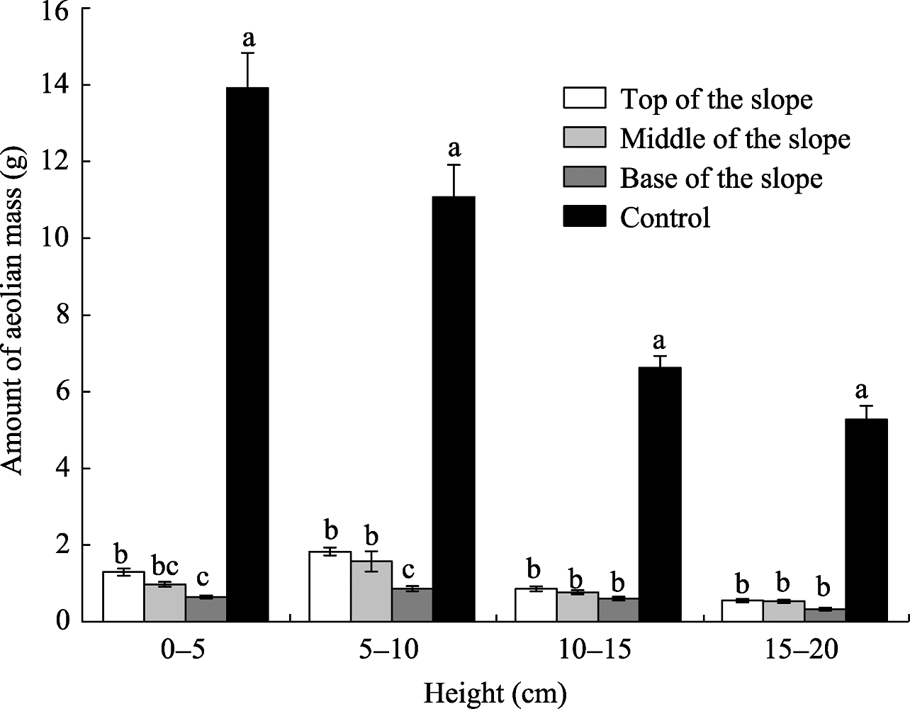
Fig. 5
Amount of aeolian mass at different heights above the ground surface in the different tested plots. Different lowercase letters indicate significant difference among the heights at P<0.01 level. Errors bars mean standard errors.
The vertical distribution of the sand particles carried by wind in the transport layer is called the wind-sand flow structure. This structure has been investigated extensively in indoor settings (Zhang et al., 2017). The structural features of aeolian flow under different levels of vegetation coverage in our study area are shown in Figure 6. When the vegetation coverage was 15%, with increasing height above the ground surface, the wind erosion firstly decreased, then maintained a stable level, and finally decreased again. The mass flux in aeolian sand transport declined sharply at the height of 0-10 cm. Wind erosion was mainly concentrated at the lower heights above the ground surface (0-30 cm) under the 15% vegetation coverage. The mass flux in aeolian sand transport decreased with increasing vegetation coverage, and the wind-sand structure changed only at the apparent scale. The overall trend of slowly decreasing wind erosion with increasing height above the ground surface remained under the other four levels of vegetation coverage (28%, 45%, 58% and 65%). The increasing vegetation coverage could rapidly reduce the intensity of wind erosion. For example, the mass flux in aeolian sand transport was only 0.1 g/(cm2•10 min) when the vegetation coverage was 65%. The higher the wind speed, the more remarkable the protection of the ground surface by vegetation. Correlation analysis indicated a significant power-function relationship between the mass flux in aeolian sand transport at different heights and the vegetation coverage (Table 3). This relationship was most significant at the height of 2 cm. When the sand collection box at the height of 30 cm above the ground surface began to deposit sand, then the wind speed was set as the threshold wind speed of sand at this moment. With increasing vegetation coverage, the threshold wind speed of sand gradually increased (Fig. 7).
Table 3
Relationship between the mass flux in aeolian sand transport (y) and the vegetation coverage (x) at the wind speed of 9 m/s
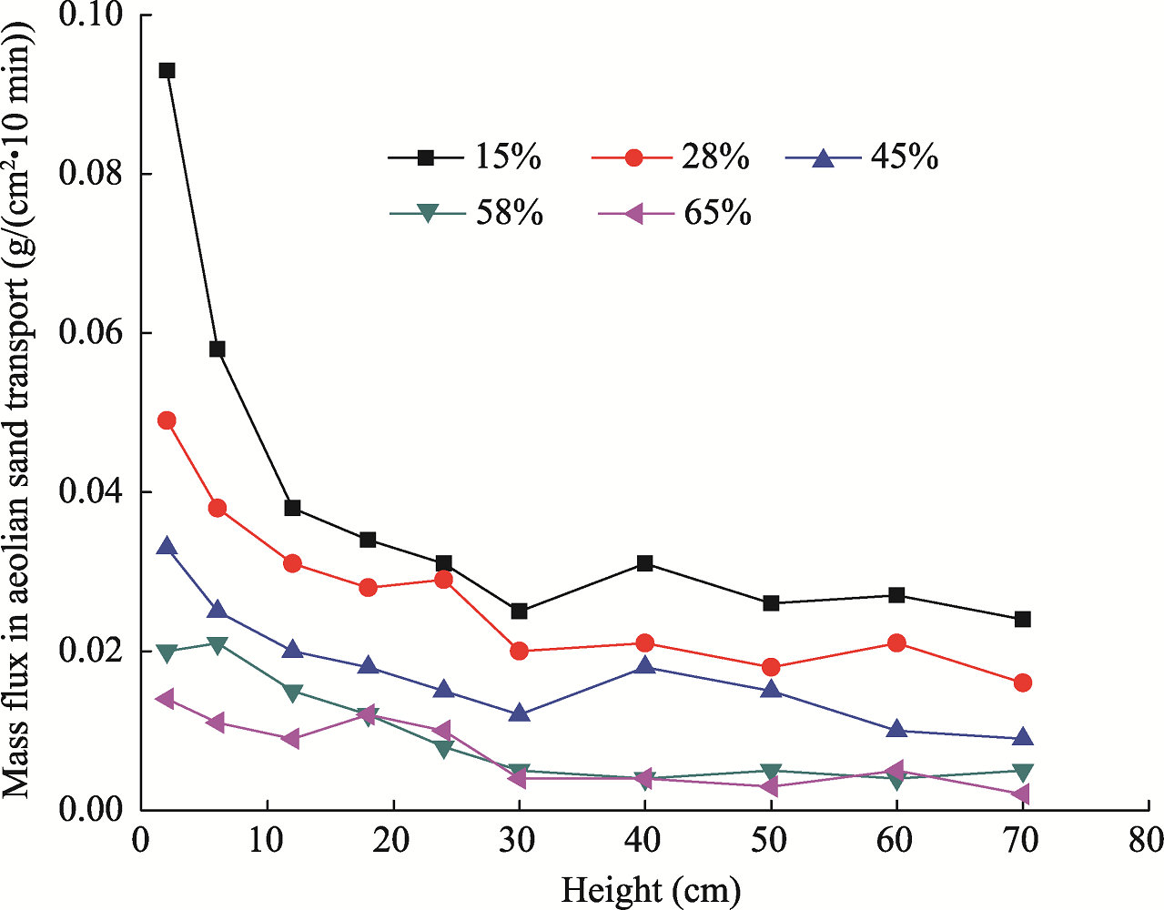
Fig. 6
Mass flux in aeolian sand transport at different heights above the ground surface under different levels of vegetation coverage at the wind speed of 9 m/s
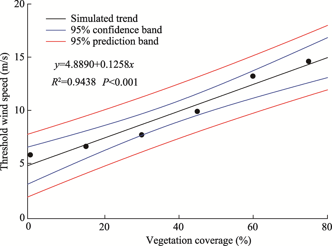
Fig. 7
Variation trend of threshold wind speed of sand with increasing vegetation coverage at the height of 30 cm above the ground surface
Figure 8 shows the variation pattern of the mass flux in aeolian sand transport under different soil moisture levels. Soil moisture is an important factor affecting soil wind erosion, particularly near the surface of the aeolian flow structure. The mass flux in aeolian sand transport gradually decreased with increasing height above the ground surface. At the wind speed of 9 m/s, when the soil was dry with a moisture content of 3.5%, the mass flux in aeolian sand transport was largest at the height of 2 cm, followed by the height of 6 cm. However, at the height of >60 cm, the effect of soil moisture on the mass flux in aeolian sand transport was very weak. The relationship between the mass flux in aeolian sand transport at different heights and the soil moisture exhibited a significant power function correlation (see Table 4). This correlation was highly significant at the height of 2 cm. The change in the coefficients of the fitting equations was consistent with the change in the mass flux, which decreased with increasing height.
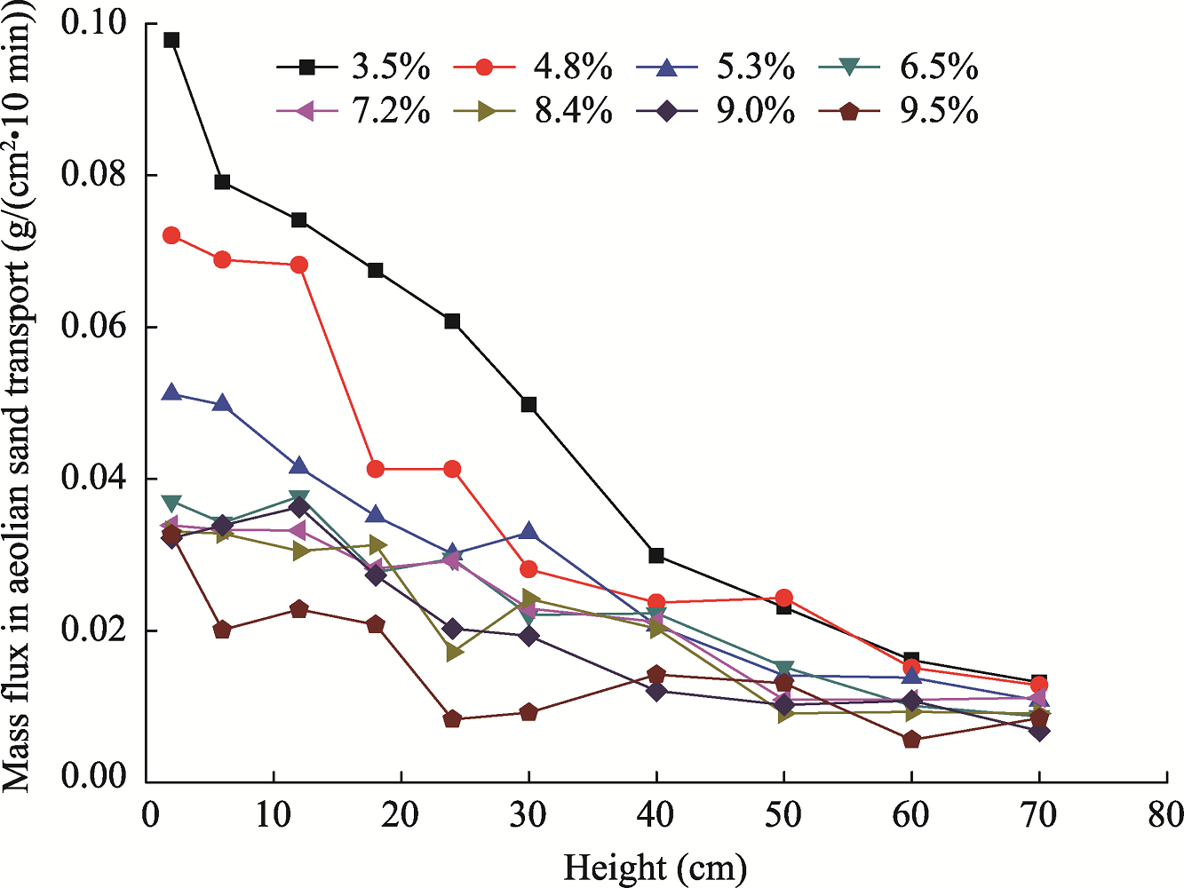
Fig. 8
Mass flux in aeolian sand transport at different heights above the ground surface under different levels of soil moisture
Table 4
Relationship between the mass flux in aeolian sand transport (y) and the soil moisture (x)
Wind is a direct force driving soil erosion, and wind speed directly affects the intensity of wind erosion. Variations of the mass flux in aeolian sand transport at different heights above the ground surface under different levels of wind speed are shown in Figure 9. The mass flux in aeolian sand transport increased with increasing wind speed. The lower the height, the larger the difference in mass flux among wind speeds. Wind erosion mainly occurred near the surface under each wind speed, increasing rapidly with increasing wind speed. Only limited wind erosion was observed at a high height above the ground surface, which was less affected by the wind speed. The correlation between the mass flux in aeolian sand transport at different heights and the wind speed exhibited a significant power function (Table 5), which was highly significant at the heights of 2-40 cm. To a certain extent, it is proved that the sand transport rate increased with increasing wind speed. However, there was no obvious difference among different wind speeds for a certain height. Based on the abovementioned results, we concluded that the wind erosion was a comprehensive effect caused by wind speed, vegetation coverage and soil moisture.
Fig. 9
Mass flux in aeolian sand transport at different heights above the ground surface under different levels of wind speed
Table 5
Relationship between the mass flux in aeolian sand transport (y) and the wind speed (x)
Wind erosion is a complex process with complicated mechanisms and factors, so it is difficult to construct a precise mathematical model for assessing this process. Modeling is generally performed using the test analysis method, in which a large amount of test data can be analyzed. In this study, three factors (vegetation coverage, wind speed and soil moisture) were used to construct a multi-factor wind erosion model. Specifically, we analyzed the field wind tunnel test data using the SAS 9.0 statistical analysis software to establish a multi-factor wind erosion model (Eq. 2):
y=1.546443+6.95437x12+240.69259x22-0.002399x32-2.198889x1x2+0.081611x1x3-0.133226x2x3-5.237444x1-29.024833x2+0.064926x3, (2)
where y is the mass flux in aeolian sand transport (g/(m2•10 min)); x1 is the soil moisture (%); x2 is the vegetation coverage (%); and x3 is the wind speed (m/s).
From this model, we obtained the standardized regression coefficients of the main effects of the three factors on wind erosion via sand-free wind (Fig. 10). The coefficients were arranged in the following descending order: wind speed, vegetation coverage and soil moisture. The standardized regression coefficient of the main effect of wind speed was positive, while those of vegetation coverage and soil moisture were negative, indicating that the higher the wind speed, the more severe the wind erosion. In contrast, the increased vegetation coverage and soil moisture could reduce wind erosion. Figure 10 also shows that the factors influencing wind erosion had different degrees of interaction in the aeolian sand transport. Analysis on the standardized regression coefficients of the main effects of the interactions showed that the coefficient of the interaction between wind speed and vegetation coverage was the highest in terms of absolute value, followed by the interaction between wind speed and soil moisture. The coefficient of the interaction between soil moisture and vegetation coverage was the lowest.
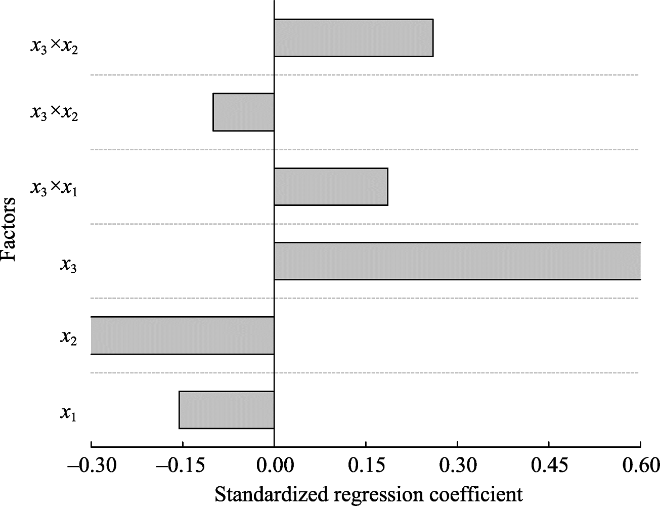
Fig. 10
Standardized regression coefficients of the main effects of wind speed, vegetation coverage, soil moisture and their interactions on aeolian sand transport via sand-free wind. x1, soil moisture; x2, vegetation coverage; x3, wind speed.
China has extensive arid and semi-arid areas which are highly susceptible to wind erosion. Wind erosion could result in poor soil fertility and sharp declines in land productivity, which in turn would affect regional socio-economic development (Wang et al., 2004; Duan et al., 2014). To provide technical support for the effective prevention of soil loss by wind erosion and sand storm disasters, we conducted an in situ analysis of wind erosion characteristics using a mobile wind tunnel in a desert steppe of Xilamuren grassland in Inner Mongolia of China. Our results indicated a significant spatial heterogeneity in the intensity of wind erosion. Specifically, the tested control plot outside the fence showed the greatest amount of erosion, followed by the top of the slope inside an enclosed desert steppe, while the base of the slope exhibited the lowest intensity of wind erosion. Wind erosion gradually decreased from the top of the slope to the base of the slope. This indicated that the fencing enclosure is conducive to restoration recovery. While in the area without fencing enclosure, soil surface is prone to erosion by wind due to poor conditions of vegetation and soil resulted from long-term grazing, tourism and other external interference (Ding et al., 2016). The vegetation conditions in the base of the slope were better with greater surface roughness, leading to much more deposition rather than erosion. In contrast, the middle and top of the slope exhibited a high intensity of wind erosion because of high airflow rate and low vegetation coverage.
With respect to the role of wind speed, the ascending order of mass flux in aeolian sand transport was as follows: 6, 9, 12, 15 and 18 m/s. The wind speed and wind erosion rate (or mass flux in aeolian sand transport) were positively correlated at different heights above the ground surface. That is, both wind erosion rate and mass flux in aeolian sand transport increased with increasing wind speed. Our findings are almost consistent with the results of Kang et al. (2012) and He et al. (2013), with little differences. This might be due to the differences in the measurement methods. In the arid and semi-arid regions, soil particles are susceptible to wind erosion, while vegetation coverage can directly prevent the surface from being eroded. Thus, vegetation is conducive to maintaining soil moisture, increasing surface roughness, blocking sand transport, reducing the turbulence of the wind, and increasing collisions between soil particles and between soil particles and plants, which can effectively lead to an increase in the deposition of soil particles (Bauer et al., 2004; Zobeck and van Pelt, 2006; Ashrafi et al., 2015). Our results showed that with increasing vegetation coverage, the amount of soil eroded by wind decreased sharply, and that the higher the wind speed was, the more efficient the protective effect of vegetation on the soil surface was. The relationship between vegetation coverage and wind erosion showed a significant power function correlation (Guo et al., 2014; John et al., 2016). For similar wind regime, the wind erosion rate decreased rapidly with increasing vegetation coverage above a threshold, which is also known as the effective coverage (Leys and Mctainsh, 1996). The wind erosion of soil could be effectively controlled when the vegetation coverage is >60% (Santiago et al., 2007; Yue et al., 2015). In this study, we also found that the threshold wind speed of soil increased with increasing vegetation coverage, indicating that vegetation coverage could change the threshold wind speed of soil, thereby reducing the mass flux in aeolian sand transport derived from wind erosion on the surface.
Soil moisture generates tension between soil particles, reinforcing the cohesive force between particles and lowering the erodibility of the soil by wind, ultimately enhancing the resistance of soil surface to wind erosion (Han et al., 2012; Nourzadeh et al., 2013; Bu et al., 2015; Bergametti et al., 2016). Furthermore, with increasing water content, the critical friction speed increased in increments proportional to the soil moisture. In this study, we found a negative correlation between soil moisture and wind speed, i.e., the higher the soil moisture, the lower the intensity of wind erosion. The threshold shear velocity increases proportionally with increasing soil moisture (Luo and Dong, 2005), while the wind erosion rate decreases with increasing soil moisture with a quadratic power function (Nourzadeh et al., 2013). Overall, the rate of sand transport decreases with increasing soil moisture. Yi et al. (2006) found that the amount of wind erosion decreased with increasing soil moisture content from 1.41% to 3.83%, showing a negative power function. Nourzadeh et al. (2013) conducted a wind tunnel simulation experiment and found that soil moisture had a remarkable inhibitive effect on the surface wind erosion and the threshold wind speed of soil increased with increasing surface moisture. A research conducted in the coast of North Wales showed that the critical humidity value affecting the transport of wet sands was in the range of 4%-6% (Wiggs et al., 2004). Similarly, He et al. (2010) found that in the farming-pastoral zone of Inner Mongolia, soil wind erosion of the farmland decreased significantly with increasing soil moisture and that the critical soil moisture was 5%. Soil moisture directly affects the resistance of soil to wind erosion. Soil exhibits strong cohesion when it is moist, and when the soil particle surface adheres to a water film, the electrostatic interactions and surface tension derived from the water film increase the adhesive force among soil particles, resulting in strong resistance to wind erosion (Zhao et al., 2012).
In this study, we performed in situ experiments with an orthogonal design to construct the mathematical model of wind erosion, from which the standardized regression coefficients of the main effects of the influencing factors on wind erosion were obtained in the following order: wind speed>vegetation coverage>soil moisture. The standardized regression coefficient of the main effect of wind speed was positive, while those of soil moisture and vegetation coverage were negative, indicating that increases in vegetation coverage and soil moisture can reduce wind erosion and that the greater the wind speed is, the more severe the wind erosion is (López et al., 2017). This finding also indicates that wind is a natural driving force of the formation and development of soil erosion, and wind speed initiates wind erosion. The transport capability of wind for particles determines the erosion and transport capability of the aeolian flow. Wind blows on the surface, and when the wind speed reaches a threshold value, soil particles are displaced and blocked by any plants. Some soil particles fall and are entrapped in the sediment, attenuating the direct impact of wind on the surface, thereby inhibiting soil wind erosion (Raupach et al., 2001; Bauer et al., 2004; Hesse and Simpson, 2006; Zobeck and van Pelt, 2006). Within a certain soil moisture range, the higher the moisture content, the stronger the tension and cohesion between the particles (Pye and Tsoar, 1990; Wang et al., 2009; Han et al., 2012; Nourzadeh et al., 2013); and the denser the plant growth, the higher the vegetation coverage and the greater the protective effect of the vegetation against aeolian flow. Thus, vegetation can effectively reduce wind speed and protect soil particles.
In this study, the effects of vegetation coverage, soil moisture and wind speed on wind erosion in a desert steppe in the Xilamuren grassland of Inner Mongolia were monitored, and the multi-factor wind erosion model was constructed. The intensity of wind erosion showed a large spatial difference. It was decreased from the top to the base of the slope inside an enclosed desert steppe, which was consistent with the spatial distribution of vegetation coverage. Wind erosion decreased rapidly with increasing vegetation coverage, showing a power function. When the surface vegetation coverage was recovered to at least 60%, it was possible to effectively control the wind erosion. Surface soil moisture was negatively correlated with the threshold wind speed of soil. The higher the soil moisture, the weaker the surface wind erosion. In terms of wind speed, the mass flux in aeolian sand transport assumed the following ascending order: 6, 9, 12, 15 and 18 m/s. The standardized regression coefficients of the main effects of these three factors on wind erosion were in the following descending order: wind speed, vegetation coverage and soil moisture. The wind erosion factors all exhibited interaction effects on aeolian sand transport to different degrees.
This study was supported by the National Natural Science of Foundation of China (51769019) and the Excellent Youth Foundation of Inner Mongolia Agricultural University (2014XYQ-8).
The authors have declared that no competing interests exist.
| [1] |
DOI:10.1016/j.geoderma.2015.08.009
URL
[CJCR: 1]
Soil plays a crucial role in ecosystem functioning. In the 1990s ecosystem services (ES) research focused on developing the concept and framework and only a few studies linked soil properties to ecosystem services. This study reviews the literature on the relationship between soils and ecosystem services and aims to contribute to the scientific understanding on soil and ecosystem services and their interrelations. Most studies have focused on provisioning and regulating ES relating to soil physico-chemical properties. Cultural services had only a few studies, and supporting services were mostly related to soil physico-chemical and biological properties. The number of ES papers increased rapidly after 2000 and in the past 5 years, regulating services such as carbon sequestration, climate and gas regulations, were commonly studied. Once the concept was established in the 1990s, studies focusing on the assessment, valuation, and payments of services became more prominent. Most soil-ES research is published in Geoderma . Soil scientists seems to be hesitant to use the term cosystem services even if their research is devoted to linking soils to ecosystem services. We suggest that future ES research should focus on exploring soil functional diversity of soil biota and the spatial aspects of soil properties to lower level ecosystem services (e.g., water purification, gene pool, and climate regulation). Soil scientists should engage professionals from other disciplines to further promote the contribution of soils to ecosystem services delivery and human well-being. ES soil studies could be used in local and national policy development and program on natural resource use and management.
|
| [2] |
DOI:10.1007/s12665-015-4153-9
URL
[CJCR: 1]
The wind erosion is the main cause of many environmental phenomena such as desertification, dust haze, sandstorms, and energy balance changes in the atmosphere. Wind erosion occurs when the friction velocity exceeds the threshold friction velocity. Threshold friction velocity depends on many parameters such as surface roughness, heat flux, moisture of soil and soil texture. In this article, the horizontal and vertical fluxes of particles due to wind erosion have been studied using a numerical method. Atmospheric boundary layer has been modeled with computational fluid dynamic for different wind profiles and the flow field near the surface has been solved. The values of velocity’s components of air flow have been used to calculate wind erosion fluxes according to balance equations of particles. The erosion flux of particles in terms of suspension, saltation and creeping have been calculated according to threshold friction velocities. Finally, the relation between fluxes has been determined and the correlation of erosion flux and direct suspension in terms of friction velocity and particle diameter has been presented. Comparing the results with previous works revealed that the value of direct suspension of particle C (kg/ms) is related to total erosion flux Q (kg/ms) as Q 02=0230,553 C 2 02+026.4316 C 02+020.0017.
|
| [3] |
DOI:10.1016/j.geomorph.2003.09.008
URL
[CJCR: 2]
Investigations of wind-field modification due to the presence of saltating sediments have relied heavily on wind tunnels, which are known to impose geometric constraints on full boundary layer development. There remains great uncertainty as to which portion of the vertical wind-speed profile to analyze when deriving estimates of shear velocity or surface roughness length because the lower sections are modified to varying degree by saltation, whereas the upper segments may be altered by artificially induced wake-like effects. Thus, it is not obvious which of several alternative velocity-profile parameterizations (e.g., Law of the Wall, Velocity Defect Law, Wake Law) should be employed under such circumstances. A series of experimental wind-tunnel runs was conducted across a range of wind speed using fine- and coarse-grained sand to collect high-quality, fine-resolution data within and above the saltation layer using thermal anemometry and ruggedized probes. After each run, the rippled bottom was fixed with fine mist, and the experiment repeated without saltation. The measured wind-speed profiles were analyzed using six different approaches to derive estimates of shear velocity and roughness length. The results were compared to parameter estimates derived directly from sediment transport rate measurements, and on this basis, it is suggested that one of the six approaches is more robust than the others. Specifically, the best estimate of shear velocity during saltation is provided by the logarithmic law applied to the profile data within about 0.05 m of the bottom, despite the fact that this near-surface region is where profile modification by saltating sediments is most pronounced. Uncertainty remains as to whether this conclusion can be generalized to field situations because progressive downwind adjustments in the interrelationship between the saltation layer and the wind field are anticipated in wind tunnels, thereby confounding most analyses based on equilibrium assumptions.
|
| [4] |
DOI:10.1002/2016GL069324
URL
[CJCR: 2]
Simultaneous measurements of saltation, wind speed, and rainfall performed in Niger before, during, and after 18 rain events are used to investigate how rain events affect wind erosion in the Sahel. The results show that the inhibition of saltation is rapid but progressive after the beginning of a rain event. The decrease of sand transport during the rain event is better linked to the time elapsed from the beginning of the rain event rather than to the cumulative rainfall. In the Sahel, after a rain event, less than 12 h is necessary to almost fully restore the sand transport potential. Our results suggest that assuming that no sand transport and dust emission occur during the 12 h following the end of a rain event could be a reasonable alternative to existing parameterizations of the influence of soil moisture on the wind erosion threshold, at least for the Sahelian conditions.
|
| [5] |
DOI:10.1002/ldr.2318
URL
[CJCR: 1]
Understanding spatial and temporal patterns in land susceptibility to wind erosion is essential to design effective management strategies to control land degradation. The knowledge about the land surface susceptible to wind erosion in European contexts shows significant gaps. The lack of researches, particularly at the landscape to regional scales, prevents national and European institutions from taking actions aimed at an effective mitigating of land degradation. This study provides a preliminary pan-European assessment that delineates the spatial patterns of land susceptibility to wind erosion and lays the groundwork for future modelling activities. An Index of Land Susceptibility to Wind Erosion (ILSWE) was created by combining spatiotemporal variations of the most influential wind erosion factors (i.e. climatic erosivity, soil erodibility, vegetation cover and landscape roughness). The sensitivity of each input factor was ranked according to fuzzy logic techniques. State-of-the-art findings within the literature on soil erodibility and land susceptibility were used to evaluate the outcomes of the proposed modelling activity. Results show that the approach is suitable for integrating wind erosion information and environmental factors. Within the 34 European countries under investigation, moderate and high levels of land susceptibility to wind erosion were predicted, ranging from 25·8 to 13·065M65ha, respectively (corresponding to 5·3 and 2·9% of total area). New insights into the geography of wind erosion susceptibility in Europe were obtained and provide a solid basis for further investigations into the spatial variability and susceptibility of land to wind erosion across Europe. 08 2014 The Authors. Land Degradation and Development published by John Wiley & Sons, Ltd.
|
| [6] |
DOI:10.1002/ldr.2588
URL
[CJCR: 1]
Field measurements and observations have shown that wind erosion is a threat for numerous arable lands in the European Union (EU). Wind erosion affects both the semi-arid areas of the Mediterranean region as well as the temperate climate areas of the northern European countries. Yet, there is still a lack of knowledge, which limits the understanding about where, when and how heavily wind erosion is affecting European arable lands. Currently, the challenge is to integrate the insights gained by recent pan-European assessments, local measurements, observations and field-scale model exercises into a new generation of regional-scale wind erosion models. This is an important step to make the complex matter of wind erosion dynamics more tangible for decision-makers and to support further research on a field-scale level. A geographic information system version of the Revised Wind Erosion Equation was developed to (i) move a step forward into the large-scale wind erosion modelling; (ii) evaluate the soil loss potential due to wind erosion in the arable land of the EU; and (iii) provide a tool useful to support field-based observations of wind erosion. The model was designed to predict the daily soil loss potential at a ca. 165km2 spatial resolution. The average annual soil loss predicted by geographic information system Revised Wind Erosion Equation in the EU arable land totalled 0·5365Mg65ha61165y611, with the second quantile and the fourth quantile equal to 0·3 and 1·965Mg65ha61165y611, respectively. The cross-validation shows a high consistency with local measurements reported in literature.
|
| [7] |
DOI:10.1007/s11104-015-2609-z
URL
[CJCR: 2]
Aims: Biological soil crusts (BSCs) are generally considered to reduce wind erosion, however, the extent of reductions is highly dependent on the vegetation type, soil moisture status, and their interactions in the field. The interrelationships between these factors or their combined effects are relatively unknown. The objectives of this study were to evaluate the contributions of the crust coverage (CC), associated with the soil moisture content (SMC), and the vegetation coverage (VC) to reduce wind-erosion and to provide a basis for the effective management of BSCs. Methods: We used an orthogonal design and large-scale wind tunnel simulations to determine the erosion-resistance characteristics of BSCs, and the effects of soil moisture content (SMC), vegetation coverage (VC) and crust coverage (CC) on its wind erosion reductions. Results: Our results showed that 1) the medium SMC + low CC + high VC were the most effective contributors in decreasing the wind erosion modulus; 2) the high SMC + medium CC + low VC primarily reduced the sand-transport rate; 3) the medium SMC + high CC + low VC, with the smallest aeolian sand-flow structure index, resulted in the lowest level of aeolian sand-flow saturation; 4) the high SMC + high CC + medium VC exhibited the highest threshold wind velocity; and 5) the VC and CC were found to have significant effects on the surface roughness, but the SMC did not. Conclusions: BSCs should be strongly protected during dry and windy seasons in the spring and winter because of their value in reducing wind erosion. The BSC may be moderately disturbed during wet and weak wind seasons in the summer or autumn to ameliorate soil moisture conditions, especially in the sites with high vegetation coverage, without exacerbating wind erosion. Management that carefully considers the timing and disturbance of BSCs will help to determine the sustainable balance between the 'protection' and 'destruction' of BSCs and their effective use in reducing wind erosion.
|
| [8] |
DOI:10.3969/j.issn.1002-6819.2010.01.020
URL
[CJCR: 1]
Soil erosion by wind is a major cause of farmland degradation in arid and semiarid area of north China.In this paper,a movable wind tunnel was employed to carry out the field tests both on conservation tillage field and conventional field ploughed in fall.The characteristics of drifting sand flux for conservation tillage field and conventional tillage field,and the influencing mechanism of conservation tillage on soil erosion by wind were analyzed.It provides a theoretical basis on preventing farmland wind erosion.The results show that the wind speed can be rapidly reduced on conservation tillage field due to the standing residual stubble by contrast with the conventional tillage field, especially the logarithm relationship between wind velocity variation and residual stubble height was changed.Also the configuration of drifting sand flux was changed,which was mainly occurred at height of 180-400 mm,and accounted for 67.94%-69.28%of total sediment discharge.The maximum sediment discharge rate was emerged at height of 240 mm above the soil surface,and the shapes of drifting sand flux structure like an elephant nose,so that it was named"elephant nose effect".The total sediment discharge rate of the drifting sand flux was apparently lower than that on compared conventional farmland,indicating that the conservation tillage is an effective approach of preventing field from wind erosion and desertification.
|
| [9] |
URL
[CJCR: 2]
[Objective]The spatial heterogeneity of wind-eroded surface particles in Xilamuren desert steppe area was studied to estimate the surface-erosion-caused degradation in order to guide the protection and utilization of grassland resources in this area.[Methods]Digital image processing technique was used to obtain the composition information of soil particles in a desert steppe slope.The spatial heterogeneity of three particles as highly erodible particles(0.42 mm),semi-erodible particles(0.42~0.84 mm),and non-erodible particles(0.84mm)was analyzed with classical statistical and geostatistical methods.[Results]The results showed the percentage rank of the three kinds of soil particle was non-erodible particlessemi-erodible particleshighly erodible particles.The coefficients of the variation ranged from 11.23%to 38.17%,indicating that soil particles had a moderate degree of variability.The optimal semivariance models were exponential,spherical and spherical models respectively.The results of Kriging demonstrated that the most soil particle on the top of slope was coarse,and displayed an decreasing tread from the top to the bottom in the slope profile.The most severity of soil coarsening was found at the south and southwest of the slope,the rank of coarse degree was as follows:SouthSouthwestNorthwest WestSoutheastNorthNortheastEast.The results can provide reference to grassland desertification control in the future.[Objictive]Geostatistical analysis displayed strong spatial correlation,indicating that the spatial variability of soil particles was mainly caused by structural factors.Human activities also has its effect on it.
|
| [10] |
DOI:10.1007/s10661-014-3841-3
PMID:24891073
URL
[CJCR: 1]
Aeolian desertification is one of the most serious environmental and socioeconomic problems in arid, semi-arid, and dry subhumid zones. Understanding desertification processes and causes is important to provide reasonable and effective control measures for preventing desertification. With satellite remote sensing images as data source to assess the temporal and spatial dynamics of desertification from 1975 to 2010 in the Horqin Sandy Land, dynamic changes of aeolian desertification were detected using the human-machine interactive interpretation method. The driving factors of local desertification were analyzed based on natural and socioeconomic data. The results show that aeolian desertified land in the study area covered 30,199 km(2) in 2010, accounting for 24.1% of the study area. The total area of aeolian desertified land obviously expanded from 30,884 km(2) in 1975 to 32,071 km(2) in 1990, and gradually decreased to 30,199 km(2) in 2010; aeolian desertified land represented an increasing trend firstly and then decreased. During the past 35 years, the gravity centers of desertified lands that are classified as extremely severe and severe generally migrated to the northeast, whereas those that are moderate and slight migrated to the northwest. The migration distance of severely desertified land was the largest, which indicated the southern desertified lands were improved during the last few decades. In addition, the climatic variation in the past 35 years has been favorable to desertification in the Horqin Sandy Land. Aeolian desertified land rapidly expanded from 1975 to 1990 under the combined effects of climate changes and unreasonable human activities. After the 1990s, the main driving factors responsible for the decrease in desertification were positive human activities, such as the series of antidesertification and ecological restoration projects.
|
| [11] |
URL
[CJCR: 1]
Arid environments are landscapes that receive very little precipitation. Deserts can be described as an arid environment where more water is lost that gained as precipitation. Arid environments have been classified as mega thermal climates; areas of having great heat. This book focuses on regions classified as arid environments and how systematic, evidence-based synthesis may be useful for assessing ecological and cost-effective strategies for assessing revegetation in arid lands. It discusses foundations and main driving forces of socio-economic developments of arid zone and important mechanisms affecting the success of certain species over others. This book brings new research advances from around the world.
|
| [12] |
|
| [13] |
DOI:10.3390/su6128951
URL
[CJCR: 1]
Soil degradation is one of the most serious ecological problems in the world. In arid and semi-arid northern China, soil degradation predominantly arises from wind erosion. Trends in soil degradation caused by wind erosion in northern China frequently change with human activities and climatic change. To decrease soil loss by wind erosion and enhance local ecosystems, the Chinese government has been encouraging residents to reduce wind-induced soil degradation through a series of national policies and several ecological projects, such as the Natural Forest Protection Program, the National Action Program to Combat Desertification, the hree Norths Shelter Forest System, the Beijing-Tianjin Sand Source Control Engineering Project, and the Grain for Green Project. All these were implemented a number of decades ago, and have thus created many land management practices and control techniques across different landscapes. These measures include conservation tillage, windbreak networks, checkerboard barriers, the Non-Watering and Tube-Protecting Planting Technique, afforestation, grassland enclosures, etc. As a result, the aeolian degradation of land has been controlled in many regions of arid and semiarid northern China. However, the challenge of mitigating and further reversing soil degradation caused by wind erosion still remains.
|
| [14] |
DOI:10.1007/s11783-011-0280-z
URL
[CJCR: 2]
The change characters of wind-sand flow structure and sand transport rate under different wind speed and different moisture coast were studied in wind tunnel experiments.In the experiment,a standard 60-cm height vertical sand trap was used,and the moisture content was gravimetric moisture content of surface sand within 1-mm thick.Results show that the sand transport profile over the wet surface can be expressed with an exponential equation.Generally,the influence of moisture content on sand transport profile mainly focuses on the bottom of the blowing sand cloud.Meanwhile,the total sand transport drops with the increase of moisture content,and a relatively larger proportion is transported at greater height.The vertical movement of particles over higher moisture surface(0.587%M1.448%) is more sensitive to moisture content variation as compared to those over lower wet surface(M0.587%),especially,the total sand transport rate tends to be rather low(0.99 g cm-1 s-1) when M1.448%.The profile of the total sand transport rate varying with moisture content can be divided into three different gradient regions.The gradient of the curve reflects the different influences of the water regime in surface sediments.The higher moisture surface(M1.448%) merely functions as a transport plain for the saltation particles.Surface moisture content is the dominant control factor for saltation activity when the moisture content is in 0.587%-1.448%,and wind velocity will control saltation after the surface dries to the extent of M0.587%.
|
| [15] |
DOI:10.1080/00949651003724790
URL
By the room wind tunnel experiment,the change processes of soil wind erosion on two kinds of soil came from the agro-pastoral area of Inner Mongolia are studied considering the wind velocity,blown angle of wind and soil water content.The studied results showed the amount of soil wind erosion increases with the increase of wind velocity,and having a threshold wind velocity,when the wind velocity exceeds the threshold value,the soil wind erosion increased suddenly,but the different soil has different critical wind velocity;at the same time in the constant wind velocity,there is critical soil slope,when the soil slope exceeds the critical value,the change rule of soil wind erosion is from increasing to falling,the different soil has different critical soil slope,and loam soil and sandy loam soil are 10 and 20 respectively.Soil wind content has a good control of soil wind erosion.For treatment one,there is a critical soil water content with 5% for two soils,when soil moisture is larger than the critical value,soil wind erosion of two soils dramatically decrease with the increase of soil water content,and wind erosion amount of loam is more than sandy loam.For treatment two,the increasing trends of wind erosion for two soils with the falling of soil water content are no significant,especially for loam soil,and in the same soil water content,the wind erosion of two soils in treatment one is significantly higher than treatment two,this indicates reducing the disturbance of soil surface can evidently control the soil wind erosion.
|
| [16] |
|
| [17] |
DOI:10.1016/j.geomorph.2006.04.012
URL
[CJCR: 1]
Longitudinal (linear) sand dunes of the Simpson and Strzelecki dunefields in eastern central Australia present a paradox. Low levels of activity today stand in contrast to luminescence dating which has repeatedly shown deep deposits of sand on dune crests dating to within the late Holocene. In order to investigate the nature of dune activity in the Simpson trzelecki dunefield, vegetation and sand mobility were investigated by detailed vegetation survey and measurement of rippled area and loose sand depth of dunes at three sites along a climatic gradient. The response of both vegetation and sand movement to inter-annual climate variability was examined by repeat surveys of two sites in drought and non-drought conditions. Projected plant cover and plant + crust cover were found to have inverse linear relationships with rippled area and the area of deep loose sand. No relationship was found between these measures of sand movement and the plant frontal area index. A negative exponential relationship between equivalent mobile sand depth on dune surfaces and both vascular plant cover and vascular + crust cover was also found. There is no simple threshold of vegetation cover below which sand transport begins. Dunes with low perennial plant cover may form small dunes with slip faces leading to a positive feedback inhibiting ephemeral plant growth in wet years and accelerating sand transport rates. The linear dunefields are largely within the zone in which plant cover is sufficient to enforce low sand transport rates, and in which there is a strong response of vegetation and sand transport to inter-annual variation in rainfall. Both ephemeral plants (mostly forbs) and crust were found to respond rapidly to large (> 20 mm/month) rainfall events. On millennial time-scales, the level of dune activity is controlled by vegetation cover and probably not by fluctuations of wind strength. Land use or extreme, decadal time-scale, drought may destabilise dunes by removing perennial plant cover, accelerating wind erosion.
|
| [18] |
DOI:10.1007/s10980-015-0261-x
URL
[CJCR: 1]
CONTEXT: The Mongolian Plateau, comprising Inner Mongolia, China (IM) and Mongolia (MG) is undergoing consistent warming and accelerated land cover/land use change. Extensive modifications of water-limited regions can alter ecosystem function and processes; hence, it is important to differentiate the impacts of human activities and precipitation dynamics on vegetation productivity. OBJECTIVES: This study distinguished between human-induced and precipitation-driven changes in vegetation cover on the plateau across biome, vegetation type and administrative divisions. METHODS: Non-parametric trend tests were applied to the time series of vegetation indices (VI) derived from MODIS and AVHRR and precipitation from TRMM and MERRA reanalysis data. VI residuals adjusted for rainfall were obtained from the regression between growing season maximum VI and monthly accumulated rainfall (June–August) and were used to detect human-induced trends in vegetation productivity during 1981–2010. The total livestock and population density trends were identified and then used to explain the VI residual trends. RESULTS: The slope of precipitation-adjusted EVI and EVI2 residuals were negatively correlated to total livestock density (R0502=020.59 and 0.16, p02<020.05) in MG and positively correlated with total population density (R0502=020.31, p02<020.05) in IM. The slope of precipitation-adjusted EVI and EVI2 residuals were also negatively correlated with goat density (R0502=020.59 and 0.19, p02<020.05) and sheep density in MG (R0502=020.59 and 0.13, p02<020.05) but not in IM. CONCLUSIONS: Some administrative subdivisions in IM and MG showed decreasing trends in VI residuals. These trends could be attributed to increasing livestock or population density and changes in livestock herd composition. Other subdivisions showed increasing trends residuals, suggesting that the vegetation cover increase could be attributed to conservation efforts.
|
| [19] |
URL
[CJCR: 1]
The thesis studied on soil erosion characteristics in different slope aspects and position by the means of field observation.The results show that(1)Wind speed increased with the terrain rising in different terrain parts of hilly farmland with gentle slope.Mainly due to the role of micro-topography,the southern slope of the wind speed slightly higher than the northern slope.(2)Amounts of soil wind erosion and wind speed showed the variation of the exponential function.Amounts of soil wind erosion increased with wind speed rising.(3)Axis of symmetry to the top of the hill,the wind erosion of the north slope and the southern slope was a symmetrical distribution.The southern slope of wind erosion was slightly larger than the north slope.North slope erosion amount accounted for 88.6% of the southern slope.Wind erosion amounts compared to the five terrain position,maximum values did not appear in the top positions.(4)The wind erosion amount increased with height and wind speed in the height of 0~6 cm in the middle and bases of slope and 0~8 cm in the top of the slope.Wind erosion quantity with height increase showed the law of a negative exponential function in the height of 8~60 cm.When the height was bigger than 6 cm and smaller than 20 cm,lapse rates was greater.When the height was more than 20 cm,lapse rates was smaller.
|
| [20] |
|
| [21] |
|
| [22] |
DOI:10.1002/ldr.2186
URL
[CJCR: 1]
The purpose of this study is to relate soil properties affected by the deposit of materials by the wind to the percentage of vegetation surface that facilitates their accumulation. To do this, we applied artificial wind and compared its effects to natural conditions by making use of the ‘fertility islands’ generated by some species of bushes under their canopies in semiarid environments and, which according to many publications, modify soil characteristics substantially.Two very common species in our flat semiarid study area, Hammada articulata and Artemisia barrelieri, were chosen for comparison. Soil was sampled in gaps between shrubs and under canopies. Some shrubs were subjected to extra wind, whereas others were kept under natural conditions. At the end of this first stage, the islands under the canopies were sampled again, and any differences found in the data were studied. Increased retention of material affects the fertility of soils. Thus, we observed, for example, an increase in biomass carbon showing greater biological activity. Finally, we performed a statistical analysis, which resolved our hypothesis on the influence of the percentage of plant surface on the soil parameters. Copyright 08 2012 John Wiley & Sons, Ltd.
|
| [23] |
URL
[CJCR: 1]
Wind erosion is a progress that soil particles are disrupted, transported and deposited by wind, which causes much nutrient material's lose as well as soil nutrient and land productivity's decline. It also promotes the redistribution of surface soil nutrient and carbon cycling in dry lands. The erodibility of soil by wind is dependent on the state and stability of the soil aggregate, different land use types and human's activities, which farther influences the nutrient and carbon cycling and redistribution among soil, atmosphere and bio-sphere. Based on deficiency of research on wind erosion induced soil nutrient and carbon cycling in the past , we summarize the research progress and analyze the existing problem of wind erosion; furthermore, we point out that the key research work that must be done in future should be focused on:(1) the environmental problem which causes by wind erosion, (2) soil's potential wind erosion micromechanism research, and (3) wind erosion induced fine particle feedback mechanism among the soil-vegetation-atmosphere system.
|
| [24] |
DOI:10.1007/s10661-017-6183-0
URL
[CJCR: 1]
Wind erosion is a primary cause of desertification as well as being a serious ecological problem in arid and semi-arid areas across the world. To determine mechanisms for restoring desertified lands,
|
| [25] |
DOI:10.1016/j.aeolia.2014.12.002
URL
[CJCR: 1]
The effectiveness of wind erosion control by soil surface conditions and crop and weed canopy has been well studied in wind tunnel experiments. The aim of this study is to assess the combined effects of these variables under field conditions. Soil surface conditions, crop and weed coverage, plant residue, and non-erodible aggregates (NEA) were measured in the field between the fallow start and the growth period of sunflower (Helianthus annuus) and corn (Zea mays). Both crops were planted on a sandy-loam Entic Haplustoll with conventional-(CT), vertical-(VT) and no-till (NT) tillage systems. Wind erosion was estimated by means of the spreadsheet version the Revised Wind Erosion Equation and the soil coverage was measured each 15days. Results indicated that wind erosion was mostly negligible in NT, exceeding the tolerable levels (estimated between 300 and 1400kgha611year611by Verheijen et al. (2009)) only in an year with high climatic erosivity. Wind erosion exceeded the tolerable levels in most cases in CT and VT, reaching values of 17,400kgha611. Wind erosion was 2–10 times higher after planting of both crops than during fallows. During the fallows, the soil was mostly well covered with plant residues and NEA in CT and VT and with residues and weeds in NT. High wind erosion amounts occurring 30days after planting in all tillage systems were produced by the destruction of coarse aggregates and the burying of plant residues during planting operations and rains. Differences in soil protection after planting were given by residues of previous crops and growing weeds. The growth of weeds 2–4weeks after crop planting contributed to reduce wind erosion without impacting in crops yields. An accurate weeds management in semiarid lands can contribute significantly to control wind erosion. More field studies are needed in order to develop management strategies to reduce wind erosion.
|
| [26] |
|
| [27] |
|
| [28] |
DOI:10.1016/S1352-2310(01)00139-X
URL
[CJCR: 2]
A theory is developed for calculating the entrapment of particles by a windbreak, with four results. (1) The fraction of particles in the oncoming flow which pass through the windbreak, or transmittance of the windbreak for particles (σ), is related to the optical porosity (τ). The very simple approximation σ=τ works well for most applications involving the interception of spray droplets by windbreaks. Results from a field experiment agree with the theoretical predictions. (2) A new equation for the bulk drag coefficient of a windbreak is tested against numerical, wind tunnel and field experiments. This enables the bleed velocity for the flow through the windbreak to be predicted in terms of the screen pressure coefficient (k) of the barrier. (3) The relationship between k and τ is different for a vegetative barrier than for a screen across a confined duct, implying a lower k for given τ. (4) The total deposition of particles to a windbreak is determined by a trade-off between particle absorption and throughflow, implying an optimum value of τ for maximum total deposition. For particles larger than 30 μm and vegetation elements smaller than 30 mm, this occurs near τ=0.2.
|
| [29] |
DOI:10.17221/45/2016-SWR
URL
[CJCR: 1]
Windbreaks form efficient soil protection against wind erosion particularly at the time when soil cover is not protected by the cultivated plant vegetation cover. The objective of this research was to evaluate windbreaks efficiency in terms of wind speed reduction. Wind speed along the windbreaks was measured in the cadastral areas of Dobroviz and St edokluky (Czech Republic, Central Europe). The measurement was carried out by 4 stations placed at windward side (1 station at the distance of 3 times the height of the windbreak) and at leeward side of the windbreak (3 stations at the distance of 3, 6, and 9 times the height of the windbreak). Each station contained 2 anemometers situated 0.5 and 1 m above surface. The character of windbreak was described by terrestrial photogrammetry method as the value of optical porosity from the photo documentation of the windbreak at the time of field measurement. A significant dependence between the value of optical porosity and efficiency of windbreak emerged from the results. The correlation coefficient between optical porosity and wind speed reduction was in the range of 0.842 to 0.936 (statistical significance more than 95%). A significant effect of windbreak on airflow reduction was proven on the leeward side of windbreak in a belt corresponding to approximately six times the height of the windbreaks depending on the optical porosity and it was expressed by a polynomial equation.
|
| [30] |
DOI:10.1016/j.atmosenv.2007.01.014
URL
[CJCR: 1]
The shelter effect of a windbreak protects aggregate piles and provides a reduction of particle emissions in harbours. RANS (Reynolds-averaged Navier–Stokes equations) simulations using three variants of – (standard , RNG and realizable ) turbulence closure models have been performed to analyse wind flow characteristics behind an isolated fence located on a flat surface without roughness elements. The performance of the three turbulence models has been assessed by wind tunnel experiments. Cases of fences with different porosities () have been evaluated using wind tunnel experiments as well as numerical simulations. The aim is to determine an optimum porosity for sheltering effect of an isolated windbreak. A value of 0.35 was found as the optimum value among the studied porosities (0, 0.1, 0.24, 0.35, 0.4, 0.5).
|
| [31] |
DOI:10.3969/j.issn.1002-6819.2010.11.027
URL
[CJCR: 2]
In view of the serious impact of wind erosion for arid farmland in the northen foot of Yinshan Mountain of China,wind erosion simulation was made in arid farmland surface by laying gravel in different coverage and particle size. In order to providing technical basis for taking reasonable wind erosion preventing measures,it was explored for the effect on inhibition of gravel coverage and particle size on farmland soil wind erosion. Arid farmland soil erosion test was made in the 6 kinds of net wind and sand-driving wind with different gravel size and coverage. Whether net wind or sand-driving wind,it is showed that the anti-wind erosion efficiency of arid farmland will be improved by increasing gravel coverage. When the gravel coverage is exceeding 28%,it will have less effect on anti-wind erosion to increase coverage. In the same coverage,when the gravel size is increased,sediment discharge and anti-wind erosion efficiency will change slightly. Tillage farmland laid gravel can obtain good effect on not only preventing erosion,but also farming. The method is low-cost,simple and feasible. And this method is suitable for northern foot of Yinshan Mountain region climate characteristic,and is an effective way for arid farmland soil erosion prevention.
|
| [32] |
DOI:10.3788/HPLPB20102207.1462
URL
[CJCR: 3]
With more and more attention on ecological environment, there has been a rising interest in research of sandstorm in Chinese historical period. The paper made an overview of research of sandstorm in Chinese historical period. There are different academic viewpoints in cause, character and law of sandstorm in Chinese historical period. Deepening of research relies on the introduction of new technique and view.
|
| [33] |
DOI:10.1007/BF02873097
URL
[CJCR: 1]
Sandy desertification is a major kind of land desertification in the world. According to our research and practice on land degradation in northern China for nearly 30 years, we define the sandy desertification is land degradation mainly resulted from the human impacts through wind erosion in the arid, semiarid and sub-humid regions in northern China. The results of monitoring, based on remote sensing and GIS, show that the total area of sandy desertified land was 38.57 104 km2 in 2000, of which the slight and potential lands were 13.93 104 km2, moderate land was 9.977 104 km2, severe and very severe lands were 7.909 104 km2 and 6.756 104 km2. The sandy desertified land is mainly distributes in the interlacing agro-pastoral region, grassland, semiarid rainfed cropland and oasis irrigated cropland regions. To compare the analytical results of remote sensing data in the late 1950s, 1975, 1987 and 2000, we summarize that the development of sandy desertified land in northern China had been accelerated for the last 5 decades, as its annual expanded rate was 1 560 km2 during the late 1950s and 1975, 2 100 km2 between 1975 and 1987 and 3 600 km2 from 1987 to 2000. The whole situation of sandy desertification comes to depravation and only part of it had been controlled. While most parts of regions had been suffered continually by the spread of sandy desertified land, some desertified areas in the interlacing agro-pastoral region and rainfed cropland region had been improved to be avail farmland and grassland resulted from favorable policy and patterns of landuse, which proved that the process of sandy desertified land could be managed when the fashion and intension of landuse come to be reasonable.
|
| [34] |
URL
[CJCR: 1]
Wind erosion is very severe in some regions of Northern China. This study was conducted to determine wind-resistance of fields planted with winter rapeseed using a simulated wind tunnel experiment. Treatments included four typical farmland surfaces,i.e.,winter rapeseed,winter wheat,wheat stubble without crop,and spring seeding of rapeseed; all being in Hexi Corridor,Northern China.,The results showed that the degrees of roughness for winter rapeseed,winter wheat,wheat stubble and spring seeding were 4.2,4.1,3.9,and 0.7,respectively; starting wind speeds were 14,13,12,and 6 m s-1,respectively; mean values of modulus of wind erosion were 22.3,23.3,42.5,and 543.6 kg hm-2 h-1,respectively; and the rates of transportation were 0.1,0.1,0.2,and 23.3 g m-2 min-1,respectively. Furthermore,by that the roughness and the starting wind speed change from bigger to little,and that the modulus values of wind erosion and rates of transportation change from little to bigger,Based on these four parameters described above,the wind erosion-resistance of these four farmland surfaces can be ranked in order of:winter rapeseed winter wheat wheat stubble spring seeding. Our results suggest that in order to reduce soil wind erosion,desertification and the sources of sand and dust storms,in the windy regions of Northern China,one should firstly adapt those crops living through the winter periods,including winter rapeseed and winter wheat,especially winter rapeseed; and secondly one should decrease the area of spring seeding as much as possible; and thirdly spread wheat stubble area to the areas where spring wheat has been traditionally planted using tillage practices.
|
| [35] |
DOI:10.1016/j.geomorph.2006.01.012
URL
[CJCR: 1]
We present AUSLEM (AUStralian Land Erodibility Model), a land erodibility modelling system that utilizes a rule-set of surficial and climatic thresholds applied through a Geographic Information System (GIS) modelling framework to predict landscape susceptibility to wind erosion. AUSLEM is distinctive in that it quantitatively assesses landscape susceptibility to wind erosion at a 5 5 km spatial resolution on a monthly time-step across Australia. The system was implemented for representative wet (1984), dry (1994), and average rainfall (1997) years with corresponding low, high and moderate dust storm day frequencies. Results demonstrate that AUSLEM can identify landscape erodibility, and provide an interpretation of the physical nature and distribution of erodible landscapes in Australia. Further, results offer an assessment of the dynamic tendencies of erodibility in space and time in response to the El Ni o Southern Oscillation (ENSO) and seasonal synoptic scale climate variability. A comparative analysis of AUSLEM output with independent national and international wind erosion, atmospheric aerosol and dust event records indicates a high level of model competency.
|
| [36] |
DOI:10.1016/j.geomorph.2003.09.002
URL
[CJCR: 1]
There is an increasing awareness of the influence of surface moisture on aeolian entrainment and transport of sediment. Existing wind tunnel studies have shown the impact of a limited range of moisture contents on entrainment thresholds but similar investigations are lacking in the field. The research reported here investigated the influence of changes in surface moisture content on sand entrainment and transport on a meso-tidal beach in Anglesey, North Wales. High frequency (1 Hz) wind velocities measured with hot-wire anemometers were combined with grain impact data from a Sensit monitor and mass flux measurements from a standard sand trap. Surface and near-surface moisture contents were assessed gravimetrically from surface sand scrapes and also directly by using a ThetaProbe. Critical threshold values for entrainment were specified using a modified form of the time fraction equivalence method (Stout, J.E., Zobeck, T.M., 1996a. Establishing the threshold condition for soil movement in wind-eroding fields. Proceedings of the International Conference on Air Pollution from Agricultural Operations. MWPS C-3, Kansas City, 7 9 February 1996, pp. 65 71). Results indicate a time-dependent change in dominant control of the sand transport system from moisture to wind speed, dependent upon the moisture content of the surface sediment. This interchange between controlling parameters on both entrainment and transport was very sensitive to prevailing moisture conditions and took place over a period of minutes to hours. Under conditions experienced in the experiments presented here, the critical moisture threshold for sediment entrainment was determined to be between 4% and 6%, higher than the 1 4% specified in previous wind tunnel experiments. Furthermore, a moisture content of nearly 2% (where moisture was adhered to transported sediment) appeared to have little or no impact on the rate of sand flux.
|
| [37] |
DOI:10.1016/j.catena.2011.07.002
URL
[CJCR: 1]
Wind erosion and sand storms are common phenomena in semiarid steppes of northern China and could have important impact on soil nutrient balances. Vegetation coverage is one of the key factors influencing wind erosion and aeolian dust accumulation. We conducted a field experiment to investigate the effects of vegetation coverage on airborne dust accumulation and evaluated effects of dust input on the contribution of nutrients to vegetation-mulched fields. Five vegetation coverage treatments (15%, 35%, 55%, 75% and 95%) were constructed, with 0% coverage as a control. Vegetation coverage significantly affected dust accumulation in degenerated semiarid grasslands. The amounts of dust trapped by the increasing coverages were 1.7, 1.8, 2.0, 2.1 and 2.1 times of that by the control plot, respectively. The total accumulations reached a maximum of 2.5 g m day at 75% coverage and remained stable with further increasing vegetation coverage. The particles in the dust trapped by treatment without vegetation coverage were significantly coarser than those by treatments with vegetation. In addition, the dust trapped by treatments with vegetation contained more organic carbon, nitrogen and phosphorus content than that by the control plot. This finding indicates that areas with higher vegetation coverage can obtain more nutrients by trapping airborne dust in semiarid steppes.Highlights? We demonstrate a major impact of vegetation cover on aeolian dust accumulation. ? Two critical values of vegetation cover exist for dust and for nutrient accumulation. ? 15% vegetation coverage is a suitable critical value for dust accumulation. ? The critical value of vegetation coverage is 35% for nutrients accumulation.
|
| [38] |
DOI:10.1007/s11442-016-1325-9
URL
[CJCR: 1]
China’s dryland region has serious wind erosion problem and is sensitive to climate change due to its fragile ecological condition. Wind erosion climatic erosivity is a measure of climatic factors influencing wind erosion, therefore, evaluation of its intensity and response to recent climate changes can contribute to the understanding of climate change effect on wind erosion risk. Using the FAO equation, GIS and statistical analysis tools, this study quantified the climatic erosivity, analyzed its spatiotemporal variations, and detected the trend and sensitivity to climate factors during 1961–2012. The results indicate that mean annual climatic erosivity was 2–166 at 292 stations and 237–471 at 6 stations, with the spatial distribution highly in accordance with wind speed (R 2 = 0.94). The climatic erosivity varied greatly over time with the annual variation (CV) of 14.7%–108.9% and monthly variation (concentration degree) of 0.10–0.71 in the region. Meanwhile, annual erosivity showed a significant downward trend at an annual decreasing rate mostly above 1.0%. This significantly decreasing trend was mainly attributed to the obvious decline of wind speed during the period. The results suggest that the recent climate changes were highly possible to induce a decrease of wind erosion risk in China’s dryland region.
|
| [39] |
URL
Erosion characteristics of two kinds of typical aeolian soils in Horqin Sandy Land were studied using portable wind tunnel.Results show that soil loss rates of flowing sand and farmland samples increase in power function with increasing of wind velocity.The threshold wind velocity of air-dried farmland sample is about 3.7 m/s,while the velocity of flowing sand is about 4.3 m/s.The soil loss rate of farmland sample is larger than flowing sand sample in a range of a lower wind velocity,but soil loss rate of flowing sand sample is larger than that of farmland sample when wind velocity is more than 5.7 m/s.In addition,the difference between the soil loss rates increases with increasing of wind velocity.Soil loss rate decreases in power function with increasing of soil water moisture.Anyway,loss rate of flowing sandy sample decreases more rapidly than that of farmland sample.Threshold wind velocity of flowing sand sample linearly increases with increasing of soil water moisture,while the velocity of farmland sample increases in quadratic equation with increasing of soil moisture.The difference of wind erosion characteristics of the soils is attributed to different properties of the soils.Increasing of soil water moisture can efficiently decrease wind erosion in the region in erosion duration.
|
| [40] |
DOI:10.1007/s11069-014-1516-6
URL
[CJCR: 1]
中国科学院机构知识库(CAS IR GRID)以发展机构知识能力和知识管理能力为目标,快速实现对本机构知识资产的收集、长期保存、合理传播利用,积极建设对知识内容进行捕获、转化、传播、利用和审计的能力,逐步建设包括知识内容分析、关系分析和能力审计在内的知识服务能力,开展综合知识管理。
|
| [41] |
DOI:10.1016/j.still.2016.08.006
URL
[CJCR: 3]
Farmland especially dry farmland managed in traditional ways has high wind erosion risk and contributes mainly to dust emission in arid area. Modeling predicting provides a general view to soil erosion susceptibility, and is very helpful for the understanding of potential spatial source of wind erosion. This study applied the Single-event Wind Erosion Evaluation Program (SWEEP) to predict soil wind erosion of farmland in the study area. SWEEP is a standalone version of the erosion sub-model from the Wind Erosion Prediction System (WEPS). It needs fewer calculation parameters than WEPS and is often used for single erosion events of limited size. The objective of this study was to test the feasibility of using SWEEP to estimate annual wind erosion of farmland over large areas (downwind distance >1600m) with limited wind data (2005-2011) from weather stations. We validated the simulation results by comparing them with field measurements and wind tunnel data for the same soils. The soil material eroded by wind included PM10, suspension, saltation, and creep particles. Suspension particles were the main component involved in the soil loss (averaged 61.8%). However, saltation and creep particles dominate the particle clouds for fields with a downwind length of less than 550m (averaged 56.6%), and the mass flux dominated by suspension particles stabilizes when this length is longer than 1000m (averaged 83.4%). PM 10 always has very low proportion (<2.3%). Our validation results suggest that it is feasible to use SWEEP for large areas with limited wind data. However, SWEEP could not simulate the small soil losses that occur especially at low wind velocities well. Many factors contribute to this problem, but the main one is overestimation of the threshold wind velocity. Previous research suggest that it will be difficult to replace SWEEP calculation algorithms for the threshold wind velocity, but both these algorithms and some SWEEP parameters must be improved to provide accurate predictions of soil erosion.
|
| [42] |
DOI:10.1002/esp.4045
URL
The vertical distribution of sand transport characteristics is an important issue in aeolian research. Surface characteristics affect sand transport processes, but their effects are not yet fully understood. To provide more data on this subject, we observed sand transport in 16 field experiments above surfaces covered by fine, medium and coarse sand. The sand transport rate over relatively coarser‐grained medium and coarse surfaces could be expressed as a Gaussian peak function: 65=6565+65exp (610.5[(|z – |)/]), where is the measured sediment transport at height above the bed and , , , , and are regression coefficients. The measured sand transport flux peak values () were linearly related to , and both values were significantly related to the mean surface grain size. However, for the relatively finer‐grained medium and fine sand surfaces, the sediment transport could be expressed as an exponential function. The cumulative sand transport below 0.165m was directly related to the mean surface grain size, and the relationship could be expressed as the following exponential function: 65=6565+65exp –/, where is the cumulative sand transport at height above the bed, is the mean grain size and , , and are regression coefficients. Above 0.165m, there were no significant relationships between the cumulative sand transport and the mean surface grain size. The mean grain size decreased with increasing height below the peak height and then increased with increasing height. The surface grain size distribution and proportions of the particles in different grain size categories controlled the mean grain size as a function of height. The observed changes in the sand transport rate and grain size with height will provide support for sand disaster mitigation, numerical modelling and studies of dune formation. Copyright 08 2016 John Wiley & Sons, Ltd.
|
| [43] |
URL
[CJCR: 1]
In order to explore the effects of soil moisture and physical sand contents on wind erosion modulus,seven artificial soil type treatments with physical sand contents of 20 %,30 %,40 %,50 %,60 % and 70 %,eleven treatments with soil moisture contents from 0 to 10 % at 1 % a step,and six wind speed treatments with 5,6,9,12,15 and 18 m/s,were tested in a instrument of wind erosion tunnel.The wind erosion amount was measured after 10 min wind blowing at 10 different heights of 20,60,120,180,240,300,400,500,600 and 700 mm with a cyclone sand collector,which set at placements of 1.2 m away from the wind tunnel.The results were integrated by using cubic spline interpolation method in MATLAB 7.4.0(R2007) and were computed to wind erosion modulus E.The results showed that the wind erosion amount was very small when the sand content was less than 40%,showed no significant effects for water contents and collecting heights.The amount of wind erosion collected fitted a exponential function at spatial scale when physical sand quality fraction was smaller than 20%,it well fitted both exponential or power functions when physical sand quality fraction was ranged between 20% to 40%,and it fitted a power function when the sand content was higher than 40%.The wind erosion showed an exponential increase against the heights when the wind speed was slower than 9 m/s,and changed to a power function when it was faster than 9 m/s.The total amount of wind erosion in collectors at different heights was exponentially increased with the wind speeds.There were no significant difference in wind erosion accured when the sand content less than 40%.When sand content increased to more than 40%,the wind erosion increased along with increasing sand contents,especially when the soil moisture content was lower than 3%.The E showed an exponential increase against wind speeds.We concluded that the north side region of Yinshan Mountain,Inner Mongolia,China would be an important source of sandstorm with considering the soil moisture contents and physical sand contents,because the soil moisture content,in this region,was often less than 3% to 4 % in spring and winter seasons,the sand contents were more than 50% to 80%.
|
| [44] |
DOI:10.1007/s10980-017-0585-9
URL
[CJCR: 1]
Wind erosion is a widespread environmental problem in the world’s arid landscapes, which threatens the sustainability of ecosystem services in these regions. We investigated how wind erosion and key e
|
| [45] |
DOI:10.1016/j.jhazmat.2005.11.090
PMID:16423453
URL
[CJCR: 3]
Strong atmospheric winds may cause wind erosion and dust emissions on bare, dry, erodible fields. Since these dust emissions may exceed particulate matter limits established by the United States Environmental Protection Agency, information on dust generation and transport mechanics is needed to determine the particulate hazard of dust sources. Measurements of climatic variables and airborne sediment mass and concentration were made during three strong wind events on a bare, fine sandy loam field in west Texas. This study clearly shows that dust flux estimates were very sensitive to dust concentration measurement height. PM 10 flux values estimated between heights of 2 and 5 m were 2 5 times those estimated between heights of 5 and 10 m. Tower placement in relation to the upwind unerodible boundary produced significant differences in dust flux that varied with storm intensity. During the most intense storm event, the PM 10 flux between heights of 2 and 5 m measured at the tower 200 m from the unerodible boundary was almost 2.5 times as that measured at the tower 100 m from the unerodible boundary. Vertical PM 10 dust flux was closely related with horizontal sediment flux only when the winds came from the same direction during the entire duration of horizontal sediment flux measurements.
|

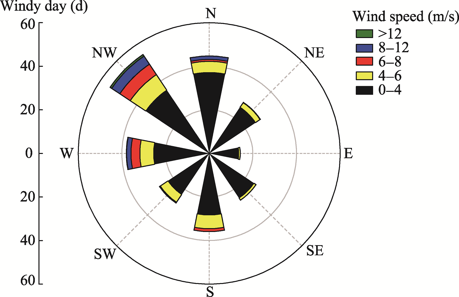
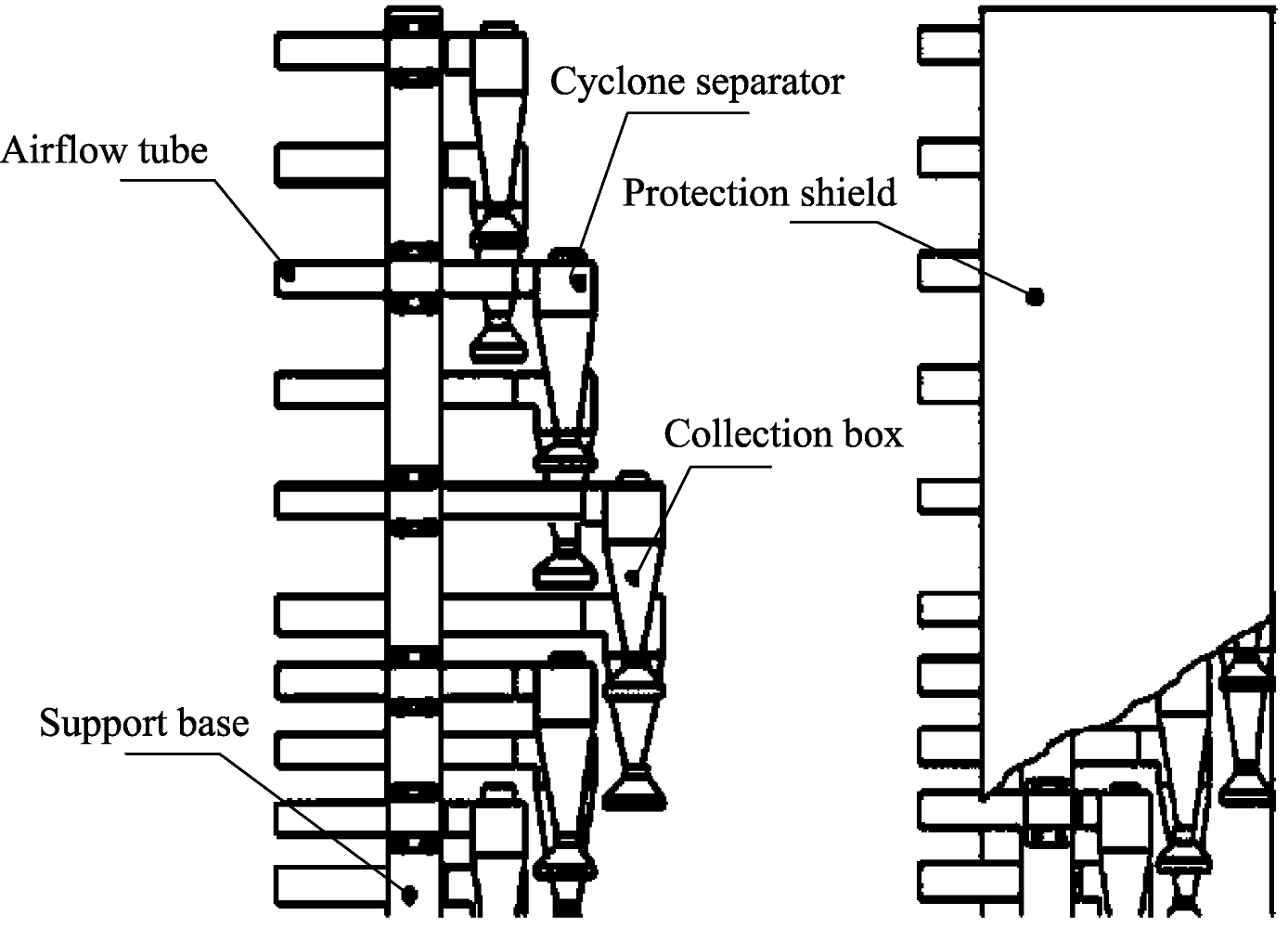