


The countries of Central Asia are collectively known as the five ''-stans'': Uzbekistan, Kyrgyzstan, Turkmenistan, Tajikistan and Kazakhstan. In recent times, the Central Asian region has been affected by the shrinkage of the Aral Sea, widespread desertification, soil salinization, biodiversity loss, frequent sand storms, and many other ecological disasters. This paper is a review article based upon the collection, identification and collation of previous studies of environmental changes and regional developments in Central Asia in the past 30 years. Most recent studies have reached a consensus that the temperature rise in Central Asia is occurring faster than the global average. This warming trend will not only result in a higher evaporation in the basin oases, but also to a significant retreat of glaciers in the mountainous areas. Water is the key to sustainable development in the arid and semi-arid regions in Central Asia. The uneven distribution, over consumption, and pollution of water resources in Central Asia have caused severe water supply problems, which have been affecting regional harmony and development for the past 30 years. The widespread and significant land use changes in the 1990s could be used to improve our understanding of natural variability and human interaction in the region. There has been a positive trend of trans-border cooperation among the Central Asian countries in recent years. International attention has grown and research projects have been initiated to provide water and ecosystem protection in Central Asia. However, the agreements that have been reached might not be able to deliver practical action in time to prevent severe ecological disasters. Water management should be based on hydrographic borders and ministries should be able to make timely decisions without political intervention. Fully integrated management of water resources, land use and industrial development is essential in Central Asia. The ecological crisis should provide sufficient motivation to reach a consensus on unified water management throughout the region.
The term ''Central Asia'', also referred to as ''Middle Asia" (Soviet parlance) or ''Inner Asia'', is used to describe the hinterland of Asia. The region is located far from oceans in every direction. According to the United Nations Educational, Scientific and Cultural Organization (UNESCO) definition, Central Asia has a border with the Caspian Sea to the west, the Da Hinggan Mountains to the east, the Altay Mountains to the north, and the Himalaya Mountains to the south. This vague definition has made it difficult for geographers to conduct regional research. Many researchers (e.g., Aizen et al., 2007; Cowan et al., 2007; Karthe et al., 2015) consider Mongolia, western China, Russian Siberia, northern Iran, Afghanistan, Pakistan and India to be within Central Asia. In a narrow sense, however, Central Asia is comprised of the five ''-stans'': Uzbekistan, Kyrgyzstan, Turkmenistan, Tajikistan and Kazakhstan (Lioubimtseva et al., 2005; Rakhmatullaev and Abdullaev, 2014).
With a total area of 4×10⁸ hm2 and a total population of around 65×106, Central Asia mainly consists of arid and semi-arid areas. Because of the region's continental location, climate and water resources have been key factors in its social and economic development since historical times. During the past 30 years, the temperature rise in Central Asia has been reported to be higher than the global average (Zhang et al., 2010; Hu et al., 2014), which has accelerated evaporation losses (Lioubimtseva and Henebry, 2009) and caused lakes to dry up (Klein et al., 2014). The shortage of water resources has had a large influence on land use changes (Saiko and Zonn, 2000; Chalov et al., 2013). Since the collapse of the former Soviet Union in 1991, a vast area of farmland has been abandoned, which has modified the landscapes and water cycles in Central Asia (Lioubimtseva et al., 2005). Kyrgyzstan and Tajikistan are mostly located in the upper reaches of trans-border rivers, and have a shared responsibility for water management with Uzbekistan, Turkmenistan and Kazakhstan (Puri and Aureli, 2010). The study of trans-border rivers is a sensitive matter for political and historical reasons. A massive number of rivers, lakes and groundwater aquifers in the region are trans-border water bodies. Therefore, cross-border cooperation is essential in the management of Central Asian water resources.
In recent years, the Aral Sea ecological disaster has received broad international attention (Erdinger et al., 2011; Cretaux et al., 2013; Rafikov and Gulnora, 2014; Micklin, 2016). Desertification, soil salinization, biodiversity loss, frequent sand storms, and many other natural disasters in Central Asia have been studied by researchers from across the world (Riedel et al., 2011; Indoitu et al., 2012; Jin et al., 2012; White, 2013; Stunzhas, 2016). Climate change, population growth, over-exploitation of water resources and inappropriate land management are considered to be responsible for environmental deterioration in Central Asia (Deng et al., 2010; Agadjanian et al., 2013; Demin, 2016; Kuzmina and Treshkin, 2016). Divergent economic interests and the conflicting needs, goals and priorities of the five Central Asian countries remain as an impediment to achieving the cooperation necessary for ecological rehabilitation and sustainable management in the region (Howard and Howard, 2016).
This paper is a review of the environmental changes and regional developments in Central Asia over the past 30 years. It is extremely important to understand the research progress and actual changes that have occurred in Central Asian countries since the collapse of the Soviet Union, because this may provide guidance for the future sustainable development of the whole region. Determining the spatiotemporal patterns of climate, water resources, land use, and socio-economic changes may enable regional developments to be better balanced in the future. Moreover, there is a general lack of research data in geoscience studies in Central Asia. A summary of the available resources and trans-border research cooperation are necessary for the execution of further related studies.
A literature review that considered climate change, water resources, and the social and economic development of Central Asia was conducted from January 1988 to December 2017 (Fig. 1). The ScienceDirect (Elsevier) database was consulted. The keywords used in searches were ''climate+Central Asia'', ''water+Central Asia'', ''land+Central Asia'', and ''social/economic development+Central Asia''. If the search words appeared in the title, abstract, or keywords of an article, then the article was preliminarily selected. A validation process was then conducted to check for double counting and erroneous articles. Finally, the total number of articles in each category was recorded. Any studies that used remote sensing were placed into a separate category.

Fig. 1
Increase in the number of English language articles in geoscience studies of Central Asia from 1988 to 2017
There were 1846 English language articles in total: 635 regarding climate, 510 regarding water, 295 regarding land, and 406 regarding social and economic development. Among them, 298 used remote sensing technology as the major research methodology. Most articles were written by Chinese, German and American authors, but this does not mean that these countries have taken the lead in geoscience research in Central Asia. Before the 1990s, Soviet scientists conducted more comprehensive studies (mostly published in Russian) of the meteorology, hydrology, geography and geology of "Middle Asia". In the past 30 years, there have been large advances in basic scientific research in this region. Scientists have still found it difficult to acquire data, which is partly the reason why remote sensing is a popular technique in studies of Central Asia (De Beurs and Henebry, 2004; Propastin et al., 2008; Zhang et al., 2010; Conrad et al., 2011; Zhou et al., 2013; Klein et al., 2014; Beurs et al., 2015).
In the past 100 years, the global climate system has undergone a significant change characterized by greenhouse gas emissions and global warming. According to the IPCC fifth assessment report, the global warming trend is still continuing, and the average temperature of the global surface has increased by 0.85°C (Stocker et al., 2013). Central Asia is one of the largest arid and semi-arid areas in the world (Knorr et al., 2001; Xu et al., 2007; Gessner et al., 2013). The natural ecosystems of Central Asia are very sensitive and vulnerable to climate change (Chen, 2012; Yin et al., 2016). Hu et al. (2014) analyzed the near-surface air temperature changes in Central Asia from 1979 to 2011 using observations from 81 meteorological stations. They found that the rise in air temperature in Central Asia occurred at a faster rate than that in surrounding areas or than the global average. The warming trend is noticeable, especially in the northern part of the region and during the cold season. The surface air temperature over Central Asia will rise between 3°C-7°C on average in the future. The largest increase in near-surface air temperature occurred in spring. According to the projected emission scenarios for the period of 2071-2100, the warming trend in summer is expected to increase (Ozturk et al., 2017). Many climate models (Pollner et al., 2008; Lioubimtseva and Henebry, 2009; Hu et al., 2014) have been used to project the temperature rise in the 21st century (Table 1). Most recent studies have reached a consensus that the temperature rise in Central Asia has occurred faster than the global average over the past 30 years. This warming trend will not only result in a higher evaporation in the basin oases, but also a significant retreat of glaciers in the mountainous areas (Sorg et al., 2012, Unger-Shayesteh et al., 2013).
Table 1
Temperature rise in Central Asia based on different studies
Spatial patterns of precipitation in Central Asia are strongly related to elevation (Klein et al., 2012; Chen et al., 2013). Annual precipitation in the mountainous areas is often more than 1000 mm, and even reaches 2000 mm in some southern parts of Central Asia. In the basin areas of Uzbekistan, Turkmenistan and Tajikistan and the southern parts of Kazakhstan, annual precipitation is less than 100 mm, but the summer temperature reaches more than 24°C on average. This has caused severe land desertification and water shortage problems.
Is there a significant response to the temperature rise in Central Asia under the background of global warming? Many researchers have studied the characteristics of climate change in Central Asia and their relationship with global warming from different perspectives. Some previous studies have shown that the convergence and divergence of atmospheric moisture will significantly increase the moisture content in the atmosphere, resulting in a pattern of "dry gets drier, wet gets wetter" (Allen and Ingram, 2002; Dore, 2005; Held and Soden, 2006). However, several recent studies have indicated the occurrence of the opposite pattern, namely "dry becomes wet, wet becomes dry" (Greve et al., 2014). The average precipitation in the arid regions has increased in both measured data and climate models over the past 30 years (Donat et al., 2016). In Central Asia, the annual precipitation has generally increased during the past 80 years, especially in winter (Chen et al., 2011). There was a significant increasing trend in precipitation in the southeast of Central Asia during 1960-2013 (Song and Bai, 2016).
Climate change in Central Asia is related to many factors, such as sea surface temperature, large-scale meridional circulation, and the El Niño-Southern Oscillation (ENSO). Some researchers have studied the mechanism of climate change in the arid and semi-arid regions of Central Asia. Lioubimtseva and Cole (2006) reported that the intensified westerly circulation and its southward movement may be the main reason for the increased precipitation over Central Asia in the context of global warming. Hu et al. (2017) used the Global Precipitation Climatology Centre (GPCC) V7 dataset to explore the spatiotemporal variations of annual precipitation. Their results indicate that annual precipitation over Central Asia is closely related to the ENSO. The ocean surface temperature anomaly has a significant effect on temperature over Central Asia. The winter temperature is much warmer when a positive sea surface temperature anomaly occurs in the equatorial central-eastern Pacific (ECEP) from autumn to winter, and vice versa. The summer temperature is much warmer (cooler) when there is a higher (lower) ocean surface temperature in the ECEP (Wang et al., 2011). Summer precipitation and temperature anomalies in Central Asia are closely related to a large-scale meridional circulation. Winter precipitation and temperature anomalies are closely connected to the singularity of the zonal circulation in the tropics. The Ural Mountains trough (ridge), western Pacific subtropical high and Arabia trough (ridge) are the main weather systems affecting the climate of Central Asia (Wang and Wei, 2012). The annual temperature and precipitation have shown a significant increasing trend, which are more rapid in the plains than in the mountainous areas of the Syr Darya Basin over Central Asia (Yao and Chen, 2015).
There are more than 1×10⁴ rivers and 1×10⁴ natural lakes in Central Asia. The lake area is more than 5×10⁵ km2, about 1/5 of the Earth's total lake area. However, most regions face water scarcity problems for two major reasons. First, there is a remarkably uneven distribution of water resources in the region, creating competition between up and downstream water users (Chalov et al., 2013). Most rivers originate from the mountainous regions of Tajikistan and Kyrgyzstan, providing relatively abundant fresh water for farmlands, forests, livestock, industry and domestic use. In contrast, Uzbekistan, Turkmenistan and Kazakhstan are facing severe water scarcity problems. Second, water quality problems are enhancing the shortage of fresh water. Salts, agrochemicals, organic pollutants and heavy metals are frequent water quality impairments in the downstream parts of most river catchments (Groll et al., 2015). Furthermore, many lake basins (including the Aral Sea, Caspian Sea, Balkhash Lake and Issyk-kul Basin) have experienced a reduction of water supply, lake area shrinkage and ecosystem degradation caused by water shortages and ecological deterioration (Table 2).
Table 2
The main rivers and lakes in Central Asia
Due to low precipitation in the basin area, nearly 98% of the river discharge originates from the mountainous regions. The Tianshan Mountains and Pamir Mountains are considered to be the fresh water tower of Central Asia. Based on statistical data for the past 30 years, glacier and snow meltwater contributes 20%-60% of the total runoff from the Tianshan Mountains, which is crucial for ensuring seasonal water availability. With higher rainfall amount in the mountains, forests also play an important role in fresh water storage and generation in the arid and semi-arid regions, but the ratios of rainfall to runoff are still lower than those in humid regions. Kyrgyzstan and Tajikistan are mostly located in the upper reaches of trans-border rivers, with an abundant water supply from the mountains. In the lower reaches, water users from Uzbekistan, Turkmenistan and Kazakhstan often complain about insufficient river outflow into their countries (Fig. 2). There are two major characteristics of dryland rivers in Central Asia. First, the seasonal fluctuations of the hydrographs are often large (Yu et al., 2015). Peak flows normally occur in summer, and most rivers have a glacier period in winter. Intermittent streams and unstable flow channels are quite common. Second, water volumes are often much lower in the downstream, with less precipitation, higher evaporation, and infiltration losses, as well as greater water consumption. Temporary flow in dryland rivers has a special biological significance, enabling certain species to breed while eliminating others (Karthe, 2018). In the arid and semi-arid regions of Central Asia, the growth of most natural vegetation (also called Tugai vegetation) is highly reliant on groundwater conditions (Yu et al., 2018). Compared with surface water abstraction, groundwater exploitation and utilization rates are relatively low, and groundwater is mainly for irrigation and domestic use (Liu et al., 2018). Tugai vegetation has a strong tolerance to dry and saline soil (Thevs et al., 2012). In farmlands, crops often have to be grown under water-stressed conditions.
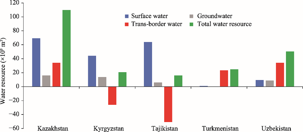
Fig. 2
Water resources of Central Asia. The double-counting of the interface between surface water and groundwater was eliminated when calculating the total water resource. The negative value of trans-border water represents the net outflow out of the country. Data source: Deng et al. (2010).
An example of an ecological catastrophe in Central Asia is the shrinkage of the Aral Sea. Because of water withdrawal for irrigation and domestic use from both tributaries, i.e., the Amu Darya and Syr Darya (Erdinger et al., 2011), the size of the Aral Sea has declined dramatically from 4×10⁵ km2 in the early 1990s to approximately 1×10⁵ km2 in 2012 (Klein et al., 2014). Many leaders from Central Asian countries and the United Nations have addressed the crisis. However, the provision of a sustainable water management plan in the Aral Sea Basin (including the Amu Darya and Syr Darya oases) is currently proceeding too slowly to prevent further water losses and environmental deterioration. The Aral Sea may vanish, as happened to Lop Nor in Xinjiang of China.
Where there is sufficient data, hydrological models can be successfully applied at the large basin scale in the arid and semi-arid lands (Yu et al., 2017). However, in studies of Central Asia, there are often problems caused by the trans-border nature of water resources. According to the CAWater-Info (2018), approximately 30% of regional groundwater is stored within a trans-boundary aquifer in the Aral Sea Basin, and the figure is much higher in the mountainous regions (e.g., Tianshan Mountains). All of the large rivers in Central Asia are basically trans-border rivers, implying that the related regions share natural resources and responsibilities, which require interstate regulation and mutual protection measures. Unfortunately, political rivalries, economic competition and nationalism have seriously undermined efforts to solve trans-border water problems during the past 30 years (Howard and Howard, 2016).
From southeast to northwest, the elevation of Central Asia drops from 7495 to 132 m. The vast region between the Pamir Mountains and the Caspian Sea is mainly comprised of desert, semidesert and steppe. The main regions include Kazakhskiy and Melkosopochnik in the north, the Turan Plain in the middle, the Caspian Plain in the west, and the Karakum Desert in the south. In the arid and semi-arid regions of Kazakhstan, Uzbekistan and Turkmenistan, there are large irrigated areas with bare lands and sparse vegetation (Klein et al., 2012). The mountain landscapes of Kyrgyzstan and Tajikistan in the southeast of Central Asia contain glaciers, snow, coniferous forests and grasslands. Modern vegetation in the arid and semi-arid regions of Central Asia evolved from ancient Mediterranean species, which has a subtropical genetic background.
The prosperity of Central Asia, as an agrarian region since ancient times, has always been very closely linked to land use. Today, farming still employs about 60% of the rural population. In the Aral Sea Basin, of the 1.55×10⁸ hm2 total land area, 0.59×10⁸ hm2 is considered cultivable, of which only about 0.10×10⁸ hm2 is actually used. About half of the cultivated land is located in oases, with fertile soils (CAWater-Info, 2018). Since the disintegration of the Soviet Union, the most significant land use changes in Central Asia have been farmland abandonment and reclamation. Based on remote sensing technology, Chen et al. (2013) found that the agricultural area in Central Asia fell from 1.03×10⁸ hm2 in 1990 to 0.54×10⁸ hm2 in 2000, and then increased to 0.70×10⁸ hm2 in 2009 (Fig. 3). The area of steppe, forest and desert increased from 1990 to 2000, and then decreased slightly with the reclamation of farmlands. The Aral Sea shrank by 63.80% from 1990 to 2009, whereas there was no significant change in the area of Balkhash and Issyk Kul. Additionally, crop productivity dropped dramatically from 1992 to 1995, then steadily increased to its former level, and remained stable in the 21st century (Chen et al., 2013).

Fig. 3
Land use changes in Central Asia from 1990 to 2009. Data source: Chen et al. (2013).
With the collapse of the Soviet Union in 1991, Central Asian countries experienced a transition from a centrally planned economy to a competitive social market economy, resulting in a profound restructuring of Central Asia's agricultural sector (Baumann et al., 2011). Markets were liberalized and foreign competition emerged (Ioffe et al., 2004). Massive landowners emerged and work forces migrated from the countryside to the cities (Lerman and Shagaida, 2007). A substantial number of farmlands were abandoned during the period that has been referred to as 'the most widespread and abrupt episode of land change in the 20th century' (Kuemmerle et al., 2011). The farmlands were later reclaimed and the landscape was renewed. While the land use changes were regulated by humans, natural conditions (e.g., temperature rise, glacier melting, water availability, precipitation and evaporation) also played a role in land use changes.
Soil salinization is another problem in the arid and semi-arid lands of Central Asia. With high water losses, low precipitation and insufficient irrigation water, land salinization has affected over 47.5% of the irrigated land in Central Asia (33.0% in Kazakhstan, 11.5% in Kyrgyzstan, 16.0% in Tajikistan, 95.9% in Turkmenistan and 50.1% in Uzbekistan) (Hamidov et al., 2016). Salinization is a serious threat to crop production in the arid and semi-arid regions (Kushiev et al., 2005). Sodic and saline soils are distributed throughout these regions. The formation and evolution of the soil patterns are linked to particular combinations of climatic and hydrological conditions in most parts of Central Asia.
The total population of Central Asia was 52.3×10⁶ in 1993, which increased to 71.9×10⁶ in 2017, with an annual growth rate of 0.81%. The population has been gradually and slowly increasing during the past three decades (Fig. 4). From 1993 to 2017, the following population increases were recorded: Kazakhstan from 16.4×10⁶ to 18.4×10⁶, Kyrgyzstan from 4.52×10⁶ to 6.13×10⁶, Tajikistan from 5.57×10⁶ to 9.11×10⁶, Turkmenistan from 3.99×10⁶ to 5.85×10⁶, and Uzbekistan from 21.9×10⁶ to 32.4×10⁶. Considering the vast territory and low population density, the population growth in Central Asia should not generate much pressure on water resources and land use at the national level.

Fig. 4
Population and GDP per capita in Central Asia in 1993 and 2017. Data source: the Research Center for Ecology and Environment of Central Asia, Chinese Academy of Sciences.
During the past 30 years, Central Asia has experienced an economic boom. After a short period of economic recession from 1991 to 1995, the resurgence of the economy has been rapid and steady. The GDP per capita of Kazakhstan increased more than 30-fold from 1993 to 2017. The other countries in the region have also experienced rapid economic and productivity growth. However, industrial development has been uneven throughout the region and has potential weaknesses. Central Asian countries, especially Kazakhstan, Turkmenistan and Uzbekistan, possess a world-famous sedimentary basin that contains huge petroleum reserves (Gu and Yu, 2017). Therefore, foreign investment has been attracted to assist these countries to develop the secondary industries. In contrast, Kyrgyzstan and Tajikistan have developed hydropower due to their hypsographic advantages and abundance of water resources. These natural-resource-oriented developments have caused many practical problems. The competition between upstream hydropower and downstream irrigation has become a significant issue in recent years. Modern management measures have generally not been applied in agricultural production. Science and technology are slowly transforming traditional farming methods. The electricity industry, mining, mechanical engineering, and a number of other industries are struggling in most of the region. The overall economic situation is not balanced and powerful enough to resist an international financial crisis.
Central Asia is one of the world's largest closed drainage basins with more than 1×10⁴ rivers and 1×10⁴ natural lakes. The vast areas of arid and semi-arid lands are highly dependent on rivers and lakes as sources of freshwater. Significant changes in water bodies have occurred in the past three decades, including large inland rivers and the Aral Sea. The shrinkage of the Aral Sea cannot be solely attributed to water abstraction over the past 30 years. Varis (2014) has proposed that irrigation-intensive industries in the former Soviet Union have drained water bodies in the Central Asian region. It is true that massive amounts of water consumption have resulted in a reduction in the water area of the Aral Sea since the 1960s (Saiko and Zonn, 2000), but the situation has not substantially changed in the last three decades. Water inflows are much lower than water losses following the breakup of the Soviet Union, and the Aral Sea has gradually dried up due to excessive irrigation water use in the upper tributaries. Today, the gradual drainage of the Aral Sea is not only a regional problem, but has also become a world famous trans-national ecological disaster (Cai et al., 2003; Kitamura et al., 2006; Qadir et al., 2009; Micklin, 2016). There is an urgent need to initiate integrated water resource management in the region to ensure ecosystem protection and socio-economic sustainability in Central Asia (Kubo et al., 2009).
Climate change and water resources have a high degree of ecological and economic importance in Central Asia, where the widespread and significant land use changes since the 1990s may also help improve our understanding of natural variability and human interaction (Chen et al., 2013). Regional precipitation mainly occurs in the Pamir Mountains and Tianshan Mountains on the southeastern edge of the region. Increasing evaporation and decreasing precipitation in the vast inland regions have resulted in a reduction of river runoff from the mountains to the plain areas. Frequent extreme natural events (such as prolonged drought and flooding) could have a significant impact on ecosystem structure and function in Central Asia (Wu et al., 2011; Zerbe and Thevs, 2011). Despite a few watershed or basin scale studies, the ecosystem responses to water availability and land use changes in Central Asia are still unclear. Temperature changes and the alternation of precipitation may also have both positive and negative impacts on ecosystems. The potential impacts of climate change and the long-term sustainability of water resources need to be further investigated (Yang et al., 2013).
Ecological and environmental problems are the main concerns of the governments of Central Asian countries. The ecosystem is fragile in the arid and semi-arid regions. Climate change and human disturbance could easily cause significant ecosystem changes or even ecological disasters (Levintanus, 1992; Erdinger et al., 2011). Spatiotemporal variations in human-induced water availability and land use changes have resulted in regional differences in ecosystem services, namely supporting services, provisioning services, regulating services and cultural services. Local residents benefit from and rely on those ecosystem services, which have been affected by changes in a number of factors, including demographic, socio-economic, political, physical and biological conditions. Dryland ecosystems should be managed in a way that enables them to provide ecosystem services that meet human demands for social development. As well as the arid and semi-arid lands of Central Asia, the mountainous regions are also vulnerable to ecological disasters (Halvorson and Hamilton, 2007). It is therefore necessary to better understand the influences and functions of ecosystem services to support policy-making and integrated management measures in Central Asia. To understand the complexity of local socio-economic and water policies that are related to sustainable development, more comprehensive and systematic studies need to be conducted at varying scales.
Extensive land use changes and migrations have occurred from the transition of the Soviet planned economy to the current market economy. Poorly managed farmlands have led to food shortages, land degradation, biodiversity loss and desertification (Gintzburger et al., 2003). Regional networks for supplementary irrigation and improved water management, crop production and rangeland management are badly needed for the five Central Asian countries. A reduction in water supply will cause economic losses and have economy-wide repercussions on employment rates, as well as the degradation of irrigated lands in downstream countries (Bekchanov and Lamers, 2016). Researchers have demanded a change in policies towards the support of integrated crop production and livestock management (Suleimenov, 2014). Studies of natural resources and environmental problems are important for ecosystem protection and socio-economic development. Agricultural production and natural resource exploitation should be managed in a sustainable way that will benefit future generations. Given that water is the key factor affecting agriculture in Central Asia, water use efficiency and agricultural productivity should be emphasized in the future (Hojyaz et al., 2013; Devkota et al., 2015).
In general, there has been a tendency to reach water management agreements based on trans-border cooperation among the Central Asian countries in recent years (Ambrosio, 2008; Rakhimov, 2010). As international attention on the region has grown, and the number of research projects investigating water and ecosystem protection in Central Asia have also grown (Khamzayeva et al., 2009; Libert and Lipponen, 2012). However, this might not be transformed into practical actions in time to prevent ecological disasters, such as the continued shrinkage of the Aral Sea. There is intense competition for water resources among agriculture, hydropower, domestic uses, grazing, and industrial uses along the river oases. Water allocation conflicts are most likely to occur in international catchments shared by poorer, less democratic, and politically unstable countries, which are governed by weak international water management institutions (Bernauer and Siegfried, 2012). There is a lack of cooperation among national authorities and ministries responsible for water policies and environmental protection. Such water ministries should be based on hydrographic borders and be able to make timely decisions without political intervention. It is very difficult to reach a consensus on trans-border environmental and financial legal regulations. To provide stable and sustainable ecosystem services, the fully integrated management of water, land use and industrial development is essential in Central Asia within the framework of policy, finance, environmental regulations, relevant organizations and technologies.
This study conducted a review of climate change, water resources and regional developments in Central Asia over the past 30 years. The different research outcomes of international researchers were considered alongside reports from the Research Center for Ecology and Environment of Central Asia, Chinese Academy of Sciences. The following important conclusions were reached.
(1) Most recent studies have shown that the temperature rise in Central Asia has been higher than that of the global average over the past 30 years. The temperature change and alternation of precipitation may have both positive and negative impacts on the fragile ecosystem of arid and semi-arid regions.
(2) The Tianshan Mountains and Pamir Mountains are considered to be the fresh water towers of Central Asia. Most of the region is facing water scarcity problems for two major reasons: the uneven distribution of water resources and the water quality problems.
(3) Trans-border water bodies are poorly managed because of the different interests of the five Central Asian countries. The over-exploitation of water resources in trans-border rivers has caused the shrinkage of the Aral Sea, along with many other ecological disasters.
(4) Since the collapse of the Soviet Union in 1991, the most significant land use changes in Central Asia have been farmland abandonment and reclamation. The agricultural area reduced by nearly 50% from 1990 to 2000, but was steadily increased in the 21st century. The area of steppe, forest and desert increased from 1990 to 2000, and then decreased slightly with the reclamation of farmlands.
(5) The population of the region has gradually increased over the past 30 years. Economic growth and industrial expansion have achieved varying degrees of success for all five Central Asian countries. However, the expansion has been mainly natural-resource-oriented and uneven. Environmental deterioration is becoming increasingly prominent with economic development in the Central Asian region.
Open Access This article is distributed under the terms of the Creative Commons Attribution License which permits any use, distribution, and reproduction in any medium, provided the original author(s) and the source are credited.
The images or other third party material in this article are included in the article's Creative Commons licence, unless indicated otherwise in a credit line to the material. If material is not included in the article’s Creative Commons licence and your intended use is not permitted by statutory regulation or exceeds the permitted use, you will need to obtain permission directly from the copyright holder.
To view a copy of this licence, visit http://creativecommons.org/licenses/by/4.0/.
This study was supported by the Strategic Priority Research Program of Chinese Academy of Sciences, Pan-Third Pole Environment Study for a Green Silk Road (XDA20060303), the Xinjiang Key Research and Development Program (2016B02017-4) and the National Nature Science Foundation of China-United Nations Environment Programme (NSFC-UNEP, 41361140361). Data collection and analysis were supported by the Research Center for Ecology and Environment of Central Asia, Chinese Academy of Sciences. Special thanks are given to the ''High-level Talents Project'' (Y871171) of Xinjiang Institute of Ecology and Geography, Chinese Academy of Sciences.
The authors have declared that no competing interests exist.
| [1] |
|
| [2] |
|
| [3] |
|
| [4] |
|
| [5] |
|
| [6] |
|
| [7] |
|
| [8] |
|
| [9] |
|
| [10] |
|
| [11] |
|
| [12] |
|
| [13] |
|
| [14] |
|
| [15] |
|
| [16] |
|
| [17] |
|
| [18] |
|
| [19] |
|
| [20] |
DOI:10.1016/S1876-3804(11)60008-6
URL
[CJCR: 2]
The five central Asian countries locate in the hinterland of Eurasian continent,whose geographical state is closed with many trans-boundary rivers.The water resources form area and consume area are not consistent in the five countries.Therefore,water resources development and utilization and the contradict between the two parts are serious,which makes the five countries become the representation of water resources development and utilization and the ecological environment protection among the global trans-boundary rivers.As a result,studying the central Asian water resources condition and development and utilization is of great significance to study the sustainable use method of trans-boundary rivers and arid area water resources.On the basis of the introduction the five central Asian countries and their main rivers,giving the assessment method of surface and ground water quantity and distribution characteristic,the paper elaborates the population and urbanization,economic growth and industrial structure,farmland and historical development of the five countries,analyzes the water resources development and utilization state of the five central Asian five countries,and also gives the summary of the problems during the process of water resources development and utilization.
|
| [21] |
|
| [22] |
|
| [23] |
|
| [24] |
DOI:10.1016/B978-0-444-52272-6.00341-X
URL
[CJCR: 3]
Salt lakes all over the world have been falling during the last century, and they continue to do so. Water withdrawal from their tributaries is one and in many cases main reason for that. Since prehistoric times, the size and shape of the Aral Sea changed depending on the amount of water arriving at the lake. The Aral Sea system is in equilibrium when the amount of water flowing in equals the amount of water evaporating over the year. During the 1950s, the government of the former USSR decided to increase the areas used for agriculture in the river valleys of the Syr Darya and the Amu Darya. To this end, water was and still is deviated from the rivers by thousands of open trenches being unsealed and leading to a massive loss of water by evaporation and seepage. In consequence, less water was and is arriving at the Aral Sea and its size is shrinking dramatically. Especially on its eastern shoreline even a small decrease in the water level leads to the exposition of large areas of former sea bottom because the lake is very shallow. Cities like Aralsk and Munyak formally located directly on the seaside are now completely surrounded by the steppe far away from the water. Although the shrinking of the Aral Sea was an economic disaster for the population living on the coast, the population in the river valleys increased significantly. Today, the major part of Uzbekistan's population is working in this area, and in Kazakhstan there are also millions of people depending on the irrigation water taken from the tributaries of the Aral Sea. The area around the Aral Sea was declared to be a one of ecological disaster, and small subsidies are (still) paid to its inhabitants. Most of the former fishermen moved away to other lakes. In consequence of the brakedown of the economic background the social structure in the population changed completely and people are suffering from unemployment and the lack of any economic perspective. However, studies performed up to now could not prove the assumption that the health of the local population impaired because of environmental pollutants having their origin in the river valleys of the Aral Seas tributaries. There is no doubt that the health of inhabitants of the area is severely affected by the environmental conditions, but not by single contaminants. People living in the Syr Darya valley and, most probably, in the Amu Darya valley suffer much more from pesticide pollution than those living in the former shoreline area of the Aral Sea. Owing to the use of certain pesticides, high concentrations of dioxins and dibenzofurans have been detected in their bodies. Water is a valuable resource and probably the most important economic factor in the countries of Central Asia. The problems of the Aral Sea cannot be solved in the short term. The problems are a result of economic decisions made in the 1950s within a different political context on the basis of a Soviet Union-wide organized economy. Now that small countries are struggling for survival of their local economies, there is, at least in the non-oil producing countries, not enough economic power for a rapid change. However, the area of the Aral Sea will enlarge with an increasing amount of water left over in the Syr Darya and the Amu Darya, even if the Aral Sea probably will not regain its former size during the next generation.
|
| [25] |
|
| [26] |
URL
[CJCR: 1]
This book presents an overview of the arid and semiarid regions of Uzbekistan, describing the native flora, together with its ecology, fodder properties and utilization. The main part of the book provides descriptions of about 150 dominant range species, including colour photographs and information on local names, chromosome numbers, morphology, reproduction, pastoral importance, fodder value, economic importance, habitat and distribution. The book also includes a physico-geographical and ecological description of Uzbekistan (including environment and vegetation types), and text sections on: the ecology, biology and economic importance of arid and semiarid rangeland plants; range improvement and rehabilitation in Uzbekistan; and nature reserves in Uzbekistan. Soil, climate and vegetation maps of the country are provided, and a brief Uzbek glossary is included.
|
| [27] |
DOI:10.1038/ngeo2247
URL
[CJCR: 1]
Changes in the hydrological conditions of the land surface have substantial impacts on society1, 2. Yet assessments of observed continental dryness trends yield contradicting results3, 4, 5, 6, 7. The concept that dry regions dry out further, whereas wet regions become wetter as the climate warms has been proposed as a simplified summary of expected8, 9, 10 as well as observed10, 11, 12, 13, 14 changes over land, although this concept is mostly based on oceanic data8, 10. Here we present an analysis of more than 300 combinations of various hydrological data sets of historical land dryness changes covering the period from 1948 to 2005. Each combination of data sets is benchmarked against an empirical relationship between evaporation, precipitation and aridity. Those combinations that perform well are used for trend analysis. We find that over about three-quarters of the global land area, robust dryness changes cannot be detected. Only 10.8% of the global land area shows a robust ry gets drier, wet gets wetter pattern, compared to 9.5% of global land area with the opposite pattern, that is, dry gets wetter, and wet gets drier. We conclude that aridity changes over land, where the potential for direct socio-economic consequences is highest, have not followed a simple intensification of existing patterns.
|
| [28] |
|
| [29] |
URL
[CJCR: 1]
The Silk Road Economic Belt is the updated version of regional economy and trade cooperation. It focuses on cooperation and development in energy, providing broad connotation and denotation and space for XinjiangCentral Asia to cooperate with each other in energy. Although it has bright prospect, the energy cooperation will still be restricted by the complex environment of Central Asia and the internal factors of Xinjiang, such as its unique economic model and industrial structure. Thus, in order to realize mutually beneficial cooperation, which is the common target of Silk Road Economic Belt, Xinjiang and Central Asia need to strengthen energy dialogue and expand the energy diplomacy, promote the construction process of Xinjiang energy strategy base, establish and perfect the information platform of Central Asia energy cooperation.
|
| [30] |
DOI:10.1659/mrd.0900
URL
[CJCR: 1]
|
| [31] |
|
| [32] |
|
| [33] |
DOI:10.1039/DT9960002261
URL
[CJCR: 1]
High water losses in the large-scale irrigation systems of Central Asia have contributed to the decline of the Aral Sea, once the fourth largest inland sea in the world. Only a small portion of the hundreds of kilometres of irrigation canals are lined, which has led to excessive withdrawal from major rivers, soil degradation, and lowered crop yields. The goal of this study was to evaluate the u...
|
| [34] |
|
| [35] |
|
| [36] |
|
| [37] |
URL
[CJCR: 1]
Based on the CRU data in Central Asia during the period of 1971 2000,in this paper the method of linear regression was used to analyze the climate change in Central Asia in recent 30 years.The results showed that the desert regions in Turkmenistan and Uzbekistan were the aridest areas with the highest temperature in Central Asia.Precipitation in Tajikistan and Kyrgyzstan in winter and spring was higher than that in summer and autumn,and temperature range was relatively low.In Kazakhstan,precipitation occurred mainly in summer,and it decreased from the west to the east;the range of temperature was high,and it was warmer in the west than that in the east.The annual range of temperature in Central Asia was low.There was a significant difference of climate between Xinjiang of China and the five countries in Central Asia,precipitation in Xinjiang occurred mainly in the Tianshan Mountains and in summer,where the warming trend was obvious,and the change trend of maximum and minimum temperature was opposite to that in the western part of Central Asia.
|
| [38] |
|
| [39] |
DOI:10.1111/j.1467-8306.2004.00441.x
URL
[CJCR: 1]
The continuous zone of settlement long considered a defining feature of Europe, is undergoing spatial fragmentation along its eastern periphery. Massive areas of rural depopulation have emerged in many regions of European Russia, including its heartland. As a result of farmland abandonment, no fewer than 20 million hectares of arable land are already deserted in European Russia, and more will be left behind in the foreseeable future. The ongoing spatial fragmentation results in two diverging structures, identified on the basis of a unique district-structured database: an emerging archipelago of commercial farming, and the so-called black holes, the likely loci of soon-to-be-abandoned land. While land abandonment is by no means a uniquely Russian phenomenon, one of its preconditions in Russia is that farmland was extended beyond environmentally reasonable limits. The rural depopulation naturally leads to the contraction of farmland. Because land that is likely to be retained under cultivation is a better match to people's actual ability to cultivate it, fewer resources are going to be wasted, and the overall efficiency of Russia's agriculture is likely to rise as a result.
|
| [40] |
|
| [41] |
|
| [42] |
|
| [43] |
|
| [44] |
|
| [45] |
|
| [46] |
|
| [47] |
|
| [48] |
|
| [49] |
|
| [50] |
|
| [51] |
|
| [52] |
|
| [53] |
|
| [54] |
|
| [55] |
|
| [56] |
|
| [57] |
|
| [58] |
|
| [59] |
URL
[CJCR: 1]
As an important part of water resources of the five countries of Central Asia,groundwater resources give critical supports to the regional economic development.Accompanied by rapid economic development, the demand of groundwater is increasing. As a result, the governments are paying more attention to groundwater resource development and utilization. However, there are noticeable issues and contradictions in water resource exploration in these countries. To be more specific, these countries lack the studies in development potential and conception planning, thus influencing the sustainable groundwater development. This paper mainly discusses groundwater development problems in the five countries of Central Asia, and briefly introduces volumes and distribution of transboundary groundwater. In addition, it analyzes the current exploitation status of groundwater and studies the potential in utilizing the resource. Most importantly, it proposes creative ways to address groundwater development issues: To make best of the resource, international cooperation is required.
|
| [60] |
|
| [61] |
|
| [62] |
|
| [63] |
DOI:10.1108/14777830810894256
URL
[CJCR: 1]
Purpose – This paper aims to demonstrate the importance of taking into account precipitation andthe vegetation response to it when trying to analyse changes of vegetation cover in drylands with highinter-annual rainfall variability.Design/methodology/approach – Linear regression models were used to determine trends inNDVI and precipitation and their interrelations for each pixel. Trends in NDVI that were entirelysupported by precipitation trends were considered to impose climate-induced vegetation change.Trends in NDVI that were not explained by trends in precipitation were considered to markhuman-induced vegetation change. Modelling results were validated by test of statistical significanceand by comparison with the data from higher resolution satellites and fieldtrips to key test sites.Findings – More than 26 percent of all vegetated area in Central Asia experienced significantchanges during 1981-2000. Rainfall has been proved to enforce most of these changes (21 percent of theentire vegetated area). The trends in vegetation activity driven by anthropogenic factor are muchscarcer and occupy about 5.75 percent of the studied area.Practical implications – Planners, decision makers and other interest groups can use the findingsof the study for assessment and monitoring land performance/land degradation over dry regions.Originality/value – The study demonstrates the importance of taking into account precipitation andthe vegetation response to it when trying to analyse changes of vegetation cover in drylands with highinter-annual rainfall variability.
|
| [64] |
DOI:10.1111/j.1745-6584.2005.00100.x
PMID:16149961
URL
[CJCR: 1]
Transboundary aquifers are as important a component of global water resource systems as are transboundary rivers; yet, their recognition in international water policy and legislation is very limited. Existing international conventions and agreements barely address aquifers and their resources. To rectify this deficiency, the International Association of Hydrogeologists and UNESCO's International Hydrological Programme have established the Internationally Shared (transboundary) Aquifer Resource Management (ISARM) Programme. This multiagency cooperative program has launched a number of global and regional initiatives. These are designed to delineate and analyze transboundary aquifer systems and to encourage riparian states to work cooperatively toward mutually beneficial and sustainable aquifer development. The agencies participating in ISARM include international and regional organizations (e.g., Organization of American States, United Nations Environment Programme, United Nations Economic Commission for Europe, Food and Agriculture Organization, and South African Development Community). Using outputs of case studies, the ISARM Programme is building scientific, legal, environmental, socioeconomic, and institutional guidelines and recommendations to aid sharing nations in the management of their transboundary aquifers. Since its start in 2000, the program has completed inventories of transboundary aquifers in the Americas and Africa, and several ISARM case studies have commenced.
|
| [65] |
|
| [66] |
DOI:10.3724/SP.J.1246.2014.03055
URL
[CJCR: 1]
The increase of irretrievable river water withdrawals and regulation of river flow has a negative effect on the natural regime of the Aral Sea. The Amu Darya River and the Syr Darya River Basins are the largest irrigated fanning areas. Their favorable soil and climatic conditions ensure guaranteed yields of various crops on irrigated lands. Since 1961, for the drastic increase of irretrievable river water withdrawal, mainly for irrigation, the inflow of river water into the Aral Sea has started to decrease significantly, accordingly the sea's hydrological and hydrochemical regimes disrupted dramatically. The sea level has continued to drop as evaporation exceeds inflow. This negatively transforms the natural environment and worsens socio-economic conditions in Priaralie as a whole, especially in the lower reaches of Amu Darya and Syr Darya, where natural conditions are largely determined by the sea's impact. At present, this causes desertification of the nonirrigated zone in the deltas, spreading to new areas as the Aral Sea dries out.
|
| [67] |
|
| [68] |
|
| [69] |
|
| [70] |
|
| [71] |
|
| [72] |
|
| [73] |
|
| [74] |
|
| [75] |
|
| [76] |
|
| [77] |
|
| [78] |
|
| [79] |
DOI:10.1038/514027a
URL
[CJCR: 1]
|
| [80] |
DOI:10.3724/SP.J.1047.2008.00014
URL
[CJCR: 1]
The temperature change is analyzed by using the surface temperature data of 69 stations from 1961-2003,which are extended forward to 1901 with an EOF interpolation method in arid and semi-arid areas in Middle part of Asia(it is abbreviated to ARID-ca hereinafter,which includes central Asia,Mongolia,Northwest China and North China).The results show that the main characteristic of temperature change is consistent arid and semi-arid areas in Middle part of Asia,at the same time 4 temperature abnormal areas are obtained by using REOF method,namely Eastern Monsoon Area(areaⅠ),Central Asia(area Ⅱ),Mongolia Plateau(area Ⅲ) and Tarim Arid Area(area Ⅳ),and every area represents distinct warming trend.The linear rates of temperature increase during 1901-2003 over the above 4 abnormal areas are about 0.19,0.16,0.23 and 0.15℃/10a for the annual mean,respectively,and those of the total ARID-AREA are about 0.18℃/10a for the annual mean and 0.21℃/10a for the winter mean,which exceed those of the Northern Hemisphere,Global and China,but are close to those of Tibetan Plateau.In the last 100 years,the temperature arid and semi-arid areas in Middle part of Asia has come through relative slowly warming process before 1970′s and obvious warming after 1970′s,and the rate of temperature increase is higher and higher.Comparing with East China,the temperature change has notable difference arid and semi-arid areas in Middle part of Asia.There is no obvious warming from 1920′s to 1940′s,but there are 6 zigzagged increased-decreased cycles of temperature in the whole warming process arid and semi-arid areas in Middle part of Asia,namely 1920′s,1940′s,1960′s,1980′s,1990′s and early this century.The duration of temperature increase is longer and the amplitude is bigger,whereas it is shorter and smaller in period of temperature decrease.No matter in the stages of temperature increase or decrease,the vary amplitude of temperature is bigger than those in East China and global average.
|
| [81] |
DOI:10.1109/IGARSS.2011.6049912
URL
[CJCR: 1]
Based on the gridded monthly air temperature data and the sea surface temperature (SST) data, the influence of SST change on two global warning periods in the 20th century over the arid central Asia is analyzed. The results show that the SST anomaly produces obvious effect on temperature. The winter temperature of the arid central Asia is much warmer (cooler) when high positive (negative) SST anomaly occurs in the equatorial central-eastern Pacific (ECEP) from autumn to winter. The summer temperature of the arid central Asia is much warmer (cooler) when higher (lower) summer SST occurs in the ECEP, the "warm pool", the Kuroshio area and the westerly drift zone. The arid central Asia made different responses to the two warming periods from the 1920s to the 1940s and from the 1970s to the 1990s, in close dependence on the anomalies of SST controlling the arid area at the two time intervals. Study shows that the impacts of global warming in the 1920s-1940s and 1970s-1990s differ upon the arid central Asia, resulting in its different responses thereto.
|
| [82] |
DOI:10.1109/IGARSS.2012.6351423
URL
Based on the gridded monthly precipitation and temperature data, and the monthly 500hPa height field data, the influence of 500hPa height change on precipitation and temperature over arid central Asia is analyzed. The results show that the summer rainfall and temperature anomaly in arid central Asia relates largely to those of large-scale meridional circulation. The winter precipitation and temperature anomaly over arid central Asia is related mainly to the singularities of zonal circulations at extra-tropic area. The main large scale synoptic systems to influence the climate change of arid central Asia include Ural Mountains trough (ridge), west Pacific sub-tropic high and Arabia trough (ridge).
|
| [83] |
|
| [84] |
|
| [85] |
DOI:10.1111/j.1365-3040.2006.001626.x
PMID:17324227
URL
[CJCR: 1]
As part of global climate change, variation in precipitation in arid ecosystems is leading to plant adaptation in water-use strategies; significant interspecific differences in response will change the plant composition of desert communities. This integrated study on the ecophysiological and individual morphological scale investigated the response, acclimation and adaptation of two desert shrubs, with different water-use strategies, to variations in water conditions. The experiments were carried out on two native dominant desert shrubs, Tamarix ramosissima and Haloxylon ammodendron , under three precipitation treatments (natural, double and no precipitation, respectively), in their original habitats on the southern periphery of Gurbantonggut Desert, Central Asia, during the growing season in 2005. Changes in photosynthesis, transpiration, leaf water potential, water-use efficiency, above-ground biomass accumulation and root distribution of the two species were examined and compared under the contrasting precipitation treatments. There were significant interspecific differences in water-use strategy and maintenance of photosynthesis under variation in precipitation. For the phreatophyte T. ramosissima , physiological activity and biomass accumulation rely on the stable groundwater, which shields it from fluctuation in the water status of the upper soil layers caused by precipitation. For the non-phreatophyte H. ammodendron , efficient morphological adjustment, combined with strong stomatal control, contributes to its acclimation to variation in precipitation. On account of its positive responses to increased precipitation, H. ammodendron is predicted to succeed in interspecific competition in a future, moister habitat.
|
| [86] |
URL
[CJCR: 1]
Ecology and environment of arid Central Asia is fragile and sensitive to climate change. However,its tempo-spatial pattern of climate change is uncertain. Owing to the sparse distribution of meteorological stations and the lack of high-precision meteorological data,using a single data source to study the regional climate change may introduce great uncertainty. Therefore,it is highly recommended to combine site observation meteorological data with reanalysis climate data to explore the tempo-spatial pattern of climate change in Central Asia. In this paper,data of31 meteorological stations(OBS),the CRU meteorological interpolation data and three high-resolution reanalysis data:CFSR,ERA-Interim and MERRA are used to analyze the temporal changes of air temperature. The applicability of the CRU,CFSR,ERA-Interim and MERRA,in Central Asia were evaluated with the observed temperature data(OBS)during 1980-2011 from 31 meteorological stations with the correlation analysis,T-test and the method of least squares. The accuracies of the reanalysis datasets were quantified with absolute error(AE),correlation coefficient(CC),mean absolute error(MAE)and root mean square error(RMSE). The evaluation results showed that all the datasets can catch the annual and seasonal temperature change well(The CC value is 0.70 to 0.98). These indicated that all the four datasets can be used to describe the temperature change of Central Asia,especially the temperature spatial pattern. For each dataset,the CRU and ERA-Interim had an underestimation for the air temperature of OBS and the underestimate range is-1.14 to-0.31 ℃. While the MERRA data had an overestimation for the OBS,the overestimate range is 0.09 to 2.03 ℃. In addition,there are best simulation results for the annual and winter temperature: the CC values are bigger than 0.9 and the MAE is-0.5 to 1.23 ℃. However,the summer simulation results were worse than spring,fall and winter: the CC values reached 0.7-0.84 and the MAE is-1.14 to 2.03 ℃. The temperature change results indicated as follows:(1)In the last 32 years,annual average air temperature has increased significantly by 0.36-0.47 ℃·(10 a)-1,which means that has already rose 1.15-1.50 ℃ in Central Asia during the period;(2)Air temperature rise is the fastest[0.71-0.93 ℃·(10 a)-1]in spring,but there is no obvious change in winter;(3)The middle,the south,the southwest and the west region of Central Asia has experienced significant warming process during the last 1990 s to the early 2000 s,while the air temperature of other parts in Central Asia has no obvious change.
|
| [87] |
|
| [88] |
|
| [89] |
|
| [90] |
DOI:10.3390/w7062821
URL
[CJCR: 1]
|
| [91] |
|
| [92] |
|
| [93] |
DOI:10.1007/978-4-431-87799-8_19
[CJCR: 1]
In recent decades, the restoration of degraded and damaged ecosystems has become a challenge for landscape management, nature conservation, and sustainable land-use development throughout the world. A
|
| [94] |
DOI:10.1029/2009WR008800
URL
[CJCR: 3]
We applied a satellite remote sensing–based evapotranspiration (ET) algorithm to assess global terrestrial ET from 1983 to 2006. The algorithm quantifies canopy transpiration and soil evaporation using a modified Penman-Monteith approach with biome-specific canopy conductance determined from the normalized difference vegetation index (NDVI) and quantifies open water evaporation using a Priestley-Taylor approach. These algorithms were applied globally using advanced very high resolution radiometer (AVHRR) GIMMS NDVI, NCEP/NCAR Reanalysis (NNR) daily surface meteorology, and NASA/GEWEX Surface Radiation Budget Release613.0 solar radiation inputs. We used observations from 34 FLUXNET tower sites to parameterize an NDVI-based canopy conductance model and then validated the global ET algorithm using measurements from 48 additional, independent flux towers. Two sets of monthly ET estimates at the tower level, driven by in situ meteorological measurements and meteorology interpolated from coarse resolution NNR meteorology reanalysis, agree favorably (root mean square error (RMSE) = 13.0–15.3 mm month611; R2 = 0.80–0.84) with observed tower fluxes from globally representative land cover types. The global ET results capture observed spatial and temporal variations at the global scale and also compare favorably (RMSE = 186.3 mm yr611; R2 = 0.80) with ET inferred from basin-scale water balance calculations for 261 basins covering 61% of the global vegetated area. The results of this study provide a relatively long term global ET record with well-quantified accuracy for assessing ET climatologies, terrestrial water, and energy budgets and long-term water cycle changes.
|
| [95] |
|
