| Research article |
|


|
|
|
| Dynamics of groundwater recharge near a semi-arid Mediterranean intermittent stream under wet and normal climate conditions |
Youssef HAJHOUJI1, Younes FAKIR1,2,*( ), Simon GASCOIN3, Vincent SIMONNEAUX3, Abdelghani CHEHBOUNI2 ), Simon GASCOIN3, Vincent SIMONNEAUX3, Abdelghani CHEHBOUNI2 |
1Faculty of Sciences Semlalia, Cadi Ayyad University, 40000, Marrakech, Morocco
2Center for Remote Sensing Application (CRSA), UM6P, 43150, Benguerir, Morocco
3Center for the Study of the Biosphere from Space (CESBIO), 31400, Toulouse, France |
|
|
|
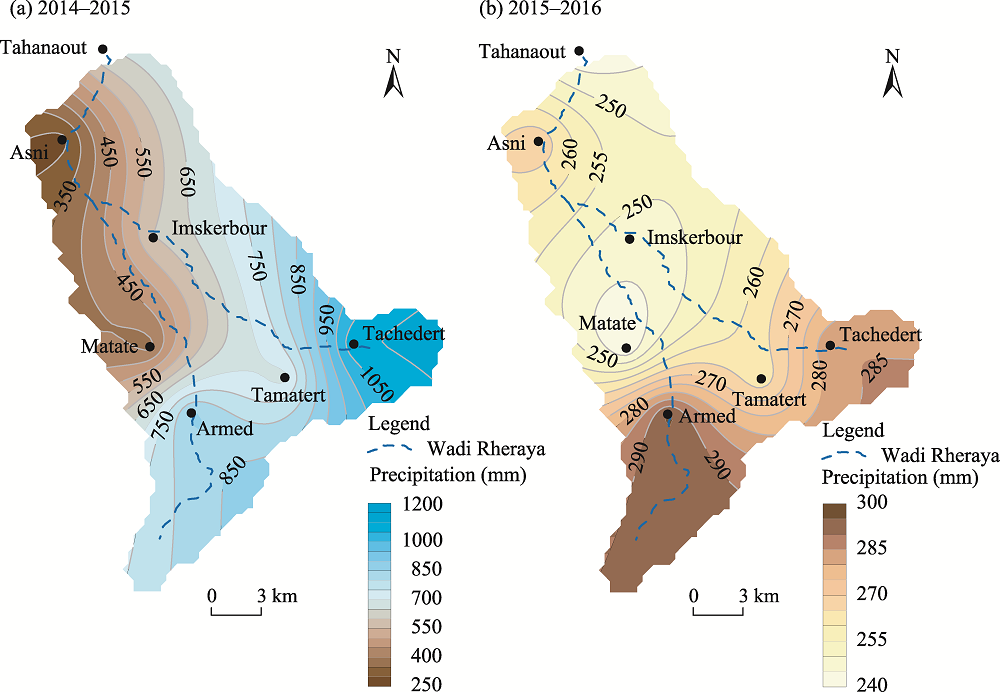
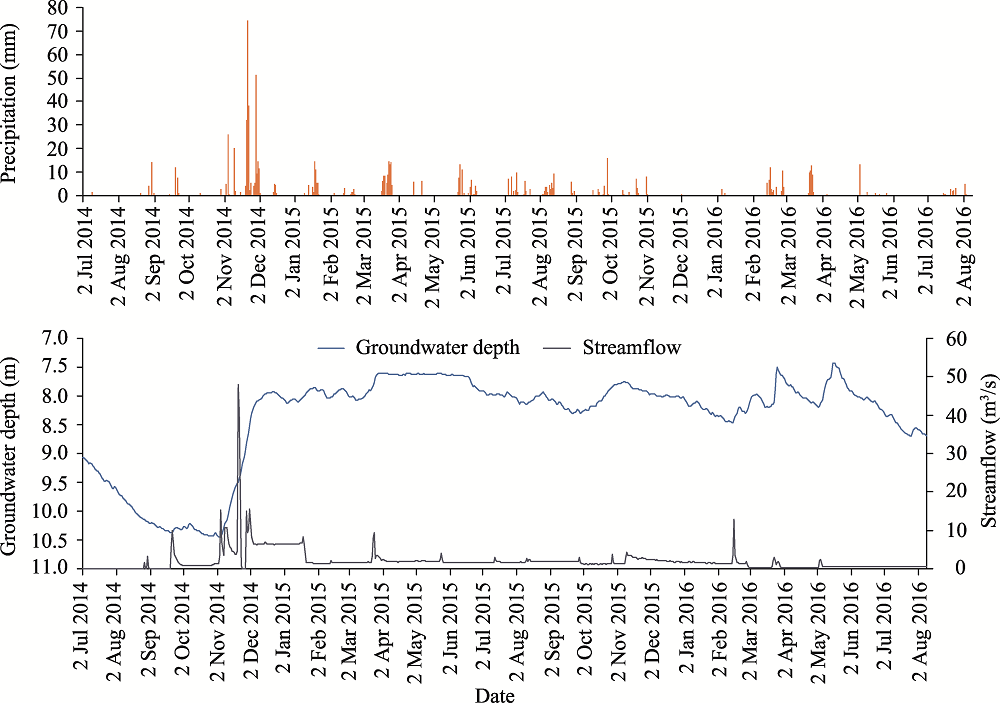
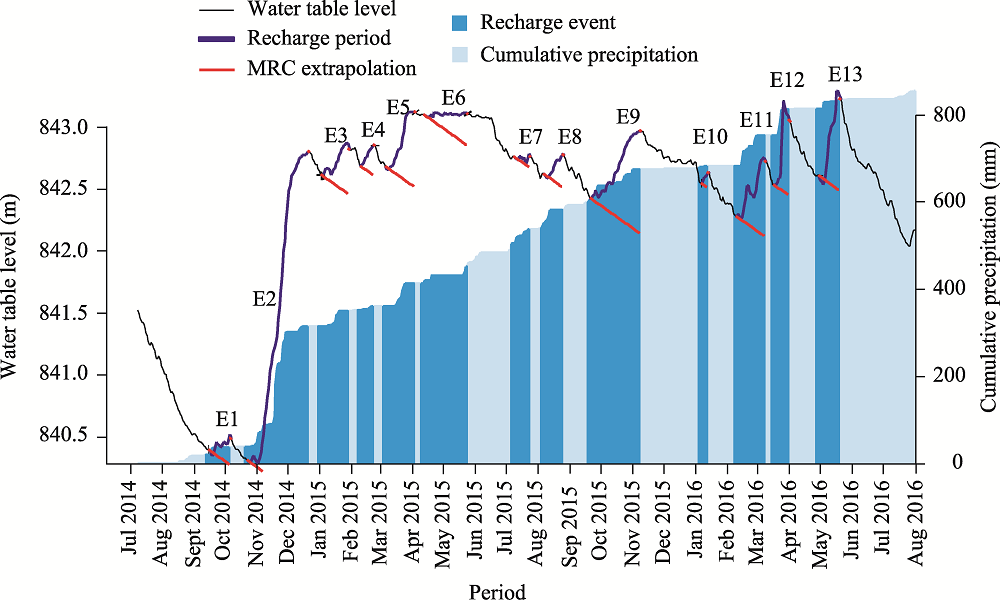
Abstract In arid and semi-arid stream-dominated systems, the temporal variability in groundwater recharge has not been widely addressed. Various questions remain about the sources of groundwater recharge, its patterns, and the appropriate measuring techniques. Hence, the main objective of the present study was to assess the changes that might affect the pattern of groundwater recharge under wetter than normal surface water availability. Therefore, the groundwater depth was monitored near a semi-arid Mediterranean intermittent stream on the piedmont of the High Atlas Mountains in the mountain catchment of the Wadi Rheraya over two hydrological years (2014-2016) with different climate conditions: extreme wet and normal conditions. Groundwater recharge was assessed using the episodic master recession algorithm. During the two years, the pattern of groundwater recharge was dominated by episodic events and by a high seasonality from wet seasons to dry seasons. In the wet year (2014-2015), the highest groundwater recharge was recorded following an extreme flood, which deeply replenished groundwater. Furthermore, an exceptional steady state of the groundwater depth was induced by a steady groundwater recharge rate. For several groundwater recharge events, the assessed recharge had multiple sources, mainly from streamflow at the local scale, but possibly from precipitation, underflow, deep percolation or irrigation return from the upstream part of the catchment. Local recharge by streamflow was likely to be short-lived, and lateral recharge was likely to last longer. Consequently, the episodic master recession algorithm estimated the total groundwater recharge that could encompass various sources. In the future, more studies and multidisciplinary approaches should be carried out to partition these sources and determine their specific contributions. In semi-arid stream-dominated systems, different groundwater recharge patterns induced by extreme hydrological events (e.g., wet events) and various potential sources of groundwater recharge should be considered when assessing and predicting groundwater recharge.
|
|
Received: 06 January 2022
Published: 31 July 2022
|
|
Corresponding Authors:
* Younes FAKIR (E-mail: fakir@uca.ac.ma)
|
|
|
| [1] |
Ashraf S, Nazemi A, Kouchak A. 2021. Anthropogenic drought dominates groundwater depletion in Iran. Scientific Reports, 11: 9135, doi: 10.1038/s41598-021-88522-y.
doi: 10.1038/s41598-021-88522-y
|
|
|
| [2] |
Batlle-Aguilar J, Cook P G. 2012. Transient infiltration from ephemeral streams: A field experiment at the reach scale. Water Resources Research, 48(11), doi: 10.1029/2012WR012009.
doi: 10.1029/2012WR012009
|
|
|
| [3] |
Boudhar A, Hanich L, Boulet G, et al. 2009. Evaluation of the snowmelt runoff model in the Moroccan High Atlas Mountains using two snow-cover estimates. Hydrological Sciences Journal, 54(6): 1094-1113.
doi: 10.1623/hysj.54.6.1094
|
|
|
| [4] |
Bouimouass H, Fakir Y, Tweed S, et al. 2020. Groundwater recharge sources in semiarid irrigated mountain fronts. Hydrological Processes, 34(7): 1598-1615.
doi: 10.1002/hyp.13685
|
|
|
| [5] |
Boukhari K, Fakir Y, Stigter T, et al. 2015. Origin of recharge and salinity and their role on management issues of a large alluvial aquifer system in the semi-arid Haouz plain, Morocco. Environmental Earth Sciences, 73(10): 6195-6212.
doi: 10.1007/s12665-014-3844-y
|
|
|
| [6] |
Cao G, Scanlon B R, Han D, et al. 2016. Impacts of thickening unsaturated zone on groundwater recharge in the North China Plain. Journal of Hydrology, 537: 260-270.
doi: 10.1016/j.jhydrol.2016.03.049
|
|
|
| [7] |
Clutter M, Ferré T P. 2018. Examining the potentials and limitations of using temperature tracing to infer water flux through unsaturated soils. Vadose Zone Journal, 17(1): 1-8.
|
|
|
| [8] |
Crosbie R S, Binning P, Kalma J D. 2005. A time series approach to inferring groundwater recharge using the water table fluctuation method. Water Resources Research, 41(1), doi: 10.1029/2004WR003077.
doi: 10.1029/2004WR003077
|
|
|
| [9] |
Cuthbert M O, Acworth R I, Andersen M S, et al. 2016. Understanding and quantifying focused, indirect groundwater recharge from ephemeral streams using water table fluctuations. Water Resources Research, 52(2): 827-840.
doi: 10.1002/2015WR017503
|
|
|
| [10] |
Cuthbert M O, Taylor R G, Favreau G, et al. 2019. Observed controls on resilience of groundwater to climate variability in sub-Saharan Africa. Nature, 572: 230-234.
doi: 10.1038/s41586-019-1441-7
|
|
|
| [11] |
Dahan O, Tatarsky B, Enzel Y, et al. 2008. Dynamics of flood water infiltration and ground water recharge in hyperarid desert. Groundwater, 46(3): 450-461.
doi: 10.1111/j.1745-6584.2007.00414.x
pmid: 18194313
|
|
|
| [12] |
Dagès C, Voltz M, Lacas J G, et al. 2008. An experimental study of water table recharge by seepage losses from a ditch with intermittent flow. Hydrological Processes, 22(18): 3555-3563.
doi: 10.1002/hyp.6958
|
|
|
| [13] |
de Vries J J, Simmers I. 2002. Groundwater recharge: an overview of processes and challenges. Hydrogeology Journal, 10(1): 5-17.
doi: 10.1007/s10040-001-0171-7
|
|
|
| [14] |
Eaton T T. 2019. Episodic and continuous recharge estimation from high-resolution well records. Groundwater, 58(4): 511-523.
doi: 10.1111/gwat.12950
|
|
|
| [15] |
Fakir Y, Bouimouass H, Constantz J. 2021. Seasonality in intermittent streamflow losses beneath a semiarid Mediterranean wadi. Water Resources Research, 57(6), doi: 10.1029/2021WR029743.
doi: 10.1029/2021WR029743
|
|
|
| [16] |
Flint A L, Flint L E, Kwicklis E M, et al. 2002. Estimating recharge at Yucca Mountain, Nevada, USA: comparison of methods. Hydrogeology Journal, 10(1): 180-204.
doi: 10.1007/s10040-001-0169-1
|
|
|
| [17] |
Hajhouji Y, Simonneaux V, Gascoin S, et al. 2018. Rainfall-Runoff modeling and hydrological regime analysis of a semi-arid snow-influenced catchment. Case of the Rheraya river (High Atlas, Morocco). La Houille Blanche, 104(3): 49-62.
doi: 10.1051/lhb/2018032
|
|
|
| [18] |
Hanich L, Chehbouni A, Gascoin S, et al. 2022. Snow hydrology in the Moroccan Atlas Mountains. Journal of Hydrology: Regional Studies, 42, doi: 10.1016/j.ejrh.2022.101101.
doi: 10.1016/j.ejrh.2022.101101
|
|
|
| [19] |
Healy R W, Cook P G. 2002. Using groundwater levels to estimate recharge. Hydrogeology Journal, 10(1): 91-109.
doi: 10.1007/s10040-001-0178-0
|
|
|
| [20] |
Healy R W. 2010. Estimating Groundwater Recharge. Cambridge: Cambridge University Press, 256.
|
|
|
| [21] |
Heppner C S, Nimmo J R. 2005. A computer program for predicting recharge with a master recession curve. Menlo Park, CA, USA: US Geological Survey, doi: 10.3133/sir20055172.
doi: 10.3133/sir20055172
|
|
|
| [22] |
Heppner C S, Nimmo J R, Folmar G J, et al. 2007. Multiple-methods investigation of recharge at a humid-region fractured rock site, Pennsylvania, USA. Hydrogeology Journal, 15(5): 915-927.
doi: 10.1007/s10040-006-0149-6
|
|
|
| [23] |
Keery J, Binley A, Crook N, et al. 2007. Temporal and spatial variability of groundwater-surface water fluxes: Development and application of an analytical method using temperature time series. Journal of Hydrology, 336(1-2): 1-16.
doi: 10.1016/j.jhydrol.2006.12.003
|
|
|
| [24] |
Kurylyk B L, Irvine D J, Bense V F. 2019. Theory, tools, and multidisciplinary applications for tracing groundwater fluxes from temperature profiles. WIREs Water, 6(1), doi: 10.1002/wat2.1329.
doi: 10.1002/wat2.1329
|
|
|
| [25] |
Lasagna M, Mancini S, de Luca D A. 2020. Groundwater hydrodynamic behaviours based on water table levels to identify natural and anthropic controlling factors in the Piedmont Plain (Italy). Science of the Total Environment, 716, doi: 10.1016/j.scitotenv.2020.137051.
doi: 10.1016/j.scitotenv.2020.137051
|
|
|
| [26] |
Lautz L K. 2012. Observing temporal patterns of vertical flux through streambed sediments using time-series analysis of temperature records. Journal of Hydrology, 464-465: 199-215.
|
|
|
| [27] |
Manning A H, Solomon D K. 2003. Using noble gases to investigate mountain-front recharge. Journal of Hydrology, 275(3-4): 194-207.
doi: 10.1016/S0022-1694(03)00043-X
|
|
|
| [28] |
Marchane A, Jarlan L, Hanich L, et al. 2013. Characterization of snow cover on the Moroccan Atlas by the MODIS sensor and relation with climate (period 2000-2011). French Journal of Photogrammetry and Remote Sensing, 204: 13-22.
|
|
|
| [29] |
McCallum A M, Andersen M S, Rau G C, et al. 2014. River-aquifer interactions in a semiarid environment investigated using point and reach measurements. Water Resources Research, 50(4): 2815-2829.
doi: 10.1002/2012WR012922
|
|
|
| [30] |
McKee T B, Doesken N J, Kleist J. 1993. The relationship of drought frequency and duration to time scales. In:Proceedings of the 8th Conference on Applied Climatology. Anaheim, California, USA, 17(22): 179-183.
|
|
|
| [31] |
Moeck C, Grech-Cumbo N, Podgorski J, et al. 2020. A global-scale dataset of direct natural groundwater recharge rates: A review of variables, processes and relationships. Science of the Total Environment, 717, doi: 10.1016/j.scitotenv.2020.137042.
doi: 10.1016/j.scitotenv.2020.137042
|
|
|
| [32] |
Nimmo J R, Horowit C, Mitchell L. 2015. Discrete-storm water-table fluctuation method to estimate episodic recharge. Groundwater, 53(2): 282-292.
doi: 10.1111/gwat.12177
pmid: 24588378
|
|
|
| [33] |
Nimmo J R, Perkins K S. 2018. Episodic master recession evaluation of groundwater and streamflow hydrographs for water-resource estimation. Vadose Zone Journal, 17(1): 1-25.
|
|
|
| [34] |
Niswonger R G, Prudic D E, Pohll G, et al. 2005. Incorporating seepage losses into the unsteady streamflow equations for simulating intermittent flow along mountain front streams. Water Resources Research, 41(6), doi: 10.1029/2004WR003677.
doi: 10.1029/2004WR003677
|
|
|
| [35] |
Rau G C, Andersen M S, McCallum A M, et al. 2010. Analytical methods that use natural heat as a tracer to quantify surface water-groundwater exchange, evaluated using field temperature records. Hydrogeology Journal, 18(5): 1093-1110.
doi: 10.1007/s10040-010-0586-0
|
|
|
| [36] |
Ronan A D, Prudic D E, Thodal C E, et al. 1998. Field study and simulation of diurnal temperature effects on infiltration and variably saturated flow beneath an ephemeral stream. Water Resources Research, 34(9): 2137-2153.
doi: 10.1029/98WR01572
|
|
|
| [37] |
Schwartz U. 2016. Factors affecting channel infiltration of floodwaters in Nahal Zin basin, Negev desert, Israel. Hydrological Processes, 30(20): 3704-3716.
doi: 10.1002/hyp.10826
|
|
|
| [38] |
Shanafield M, Cook P G, Brunner P, et al. 2012. Aquifer response to surface water transience in disconnected streams. Water Resources Research, 48(11), doi: 10.1029/2012WR012103.
doi: 10.1029/2012WR012103
|
|
|
| [39] |
Shanafield M, Cook P G. 2014. Transmission losses, infiltration and groundwater recharge through ephemeral and intermittent streambeds: A review of applied methods. Journal of Hydrology, 511: 518-529.
doi: 10.1016/j.jhydrol.2014.01.068
|
|
|
| [40] |
Shanafield M, Bourke S A, Zimmer M A, et al. 2021. An overview of the hydrology of non-perennial rivers and streams. WIREs Water, 8(2), doi: 10.1002/wat2.1504.
doi: 10.1002/wat2.1504
|
|
|
| [41] |
Shentsis I, Rosentha E. 2003. Recharge of aquifers by flood events in an arid region. Hydrological Processes, 17(4): 695-712.
doi: 10.1002/hyp.1160
|
|
|
| [42] |
Simmers I. 2003. Understanding Water in a Dry Environment (1st ed.). IAH International Contributions to Hydrogeology 23. London: CRC Press, 1-353.
|
|
|
| [43] |
Sinan M. 2000. Methodology of identification, evaluation and protection of water resources of regional aquifers by combining GIS, geophysics and geostatistics:Application to the Haouz aquifer (Marrakech, Morocco). PhD Thesis. Rabat: Mohammed V University.
|
|
|
| [44] |
Sinan M, Razack M. 2006. Estimation of the transmissivity field of a heterogeneous alluvial aquifer using transverse resistance. Application to the Haouz groundwater (Morocco). Journal of Water Science, 19(3): 221-232.
|
|
|
| [45] |
Stonestrom D A, Constantz J. 2003. Heat as a tool for studying the movement of ground water near streams. US Geological Survey Circular, 1260: 1-96.
|
|
|
| [46] |
van Lanen H A J, Peters E. 2000. Definition, effects and assessment of groundwater droughts. In: Vogt J V, Somma F. Drought and Drought Mitigation in Europe. Dordrecht: Kluwer Academic Publishers, 49-61.
|
|
|
| [47] |
Villeneuve S, Cook P G, Shanafield M, et al. 2015. Groundwater recharge via infiltration through an ephemeral riverbed, central Australia. Journal of Arid Environments, 117: 47-58.
doi: 10.1016/j.jaridenv.2015.02.009
|
|
|
| [48] |
Walvoord M A, Plummer M A, Phillips F M, et al. 2002. Deep arid system hydrodynamics 1. Equilibrium states and response times in thick desert vadose zones. Water Resources Research, 38(12): 44-1-4-15, doi: 10.1029/2001WR000824.
doi: 10.1029/2001WR000824
|
|
|
| [49] |
Watto M A, Mugera A W. 2016. Groundwater depletion in the Indus Plains of Pakistan: imperatives, repercussions and management issues. International Journal of River Basin Management, 14(4): 447-458.
doi: 10.1080/15715124.2016.1204154
|
|
|
| [50] |
Wilson J L, Guan H. 2004. Mountain-Block Hydrology and Mountain-Front Recharge. In: Hogan J F, Phillips F M, Scanlon B R, et al. Groundwater Recharge in a Desert Environment:The Southwestern United States. Washington DC: American Geophysical Union, 294.
|
|
|
| [51] |
WMO (World Meteorological Organization). 2012. Standardized Precipitation Index User Guide. In: Svoboda M, Hayes M, Wood D. WMO-No. 1090. Geneva: WMO.
|
|
|
| [52] |
Zkhiri W, Tramblay Y, Hanich L, et al. 2017. Regional flood frequency analysis in the High Atlas mountainous catchments of Morocco. Natural Hazards, 86(2): 953-967.
doi: 10.1007/s11069-016-2723-0
|
|
|
|
Viewed |
|
|
|
Full text
|
|
|
|
|
Abstract
|
|
|
|
|
Cited |
|
|
|
|
| |
Shared |
|
|
|
|
| |
Discussed |
|
|
|
|