| Research article |
|


|
|
|
| Distribution patterns of fire regime in the Pendjari Biosphere Reserve, West Africa |
Omobayo G ZOFFOUN1,2,*( ), Chabi A M S DJAGOUN1, Etotépé A SOGBOHOSSOU1,3 ), Chabi A M S DJAGOUN1, Etotépé A SOGBOHOSSOU1,3 |
1Laboratory of Applied Ecology (LEA), Faculty of Agronomic Sciences, University of Abomey-Calavi (UAC), Cotonou 01 BP 526, Benin
2GeoEnvironmemt and Biodiversity Conservation (GeoEBC) NGO, Cotonou 02 BP 775, Benin
3Department of Environment, Senghor University, 1 Place Ahmed Orabi, Al Mancheya BP 415, Alexandria 21111, Egypt |
|
|
|
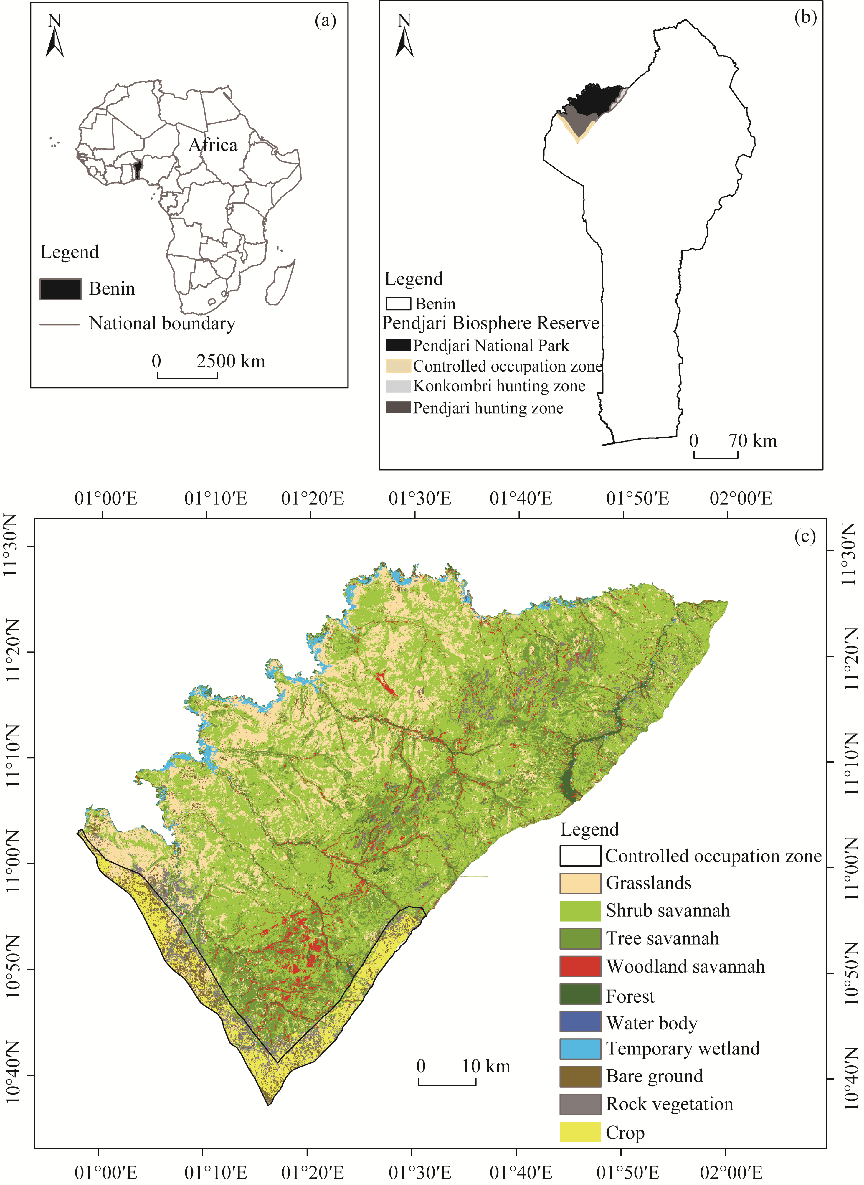
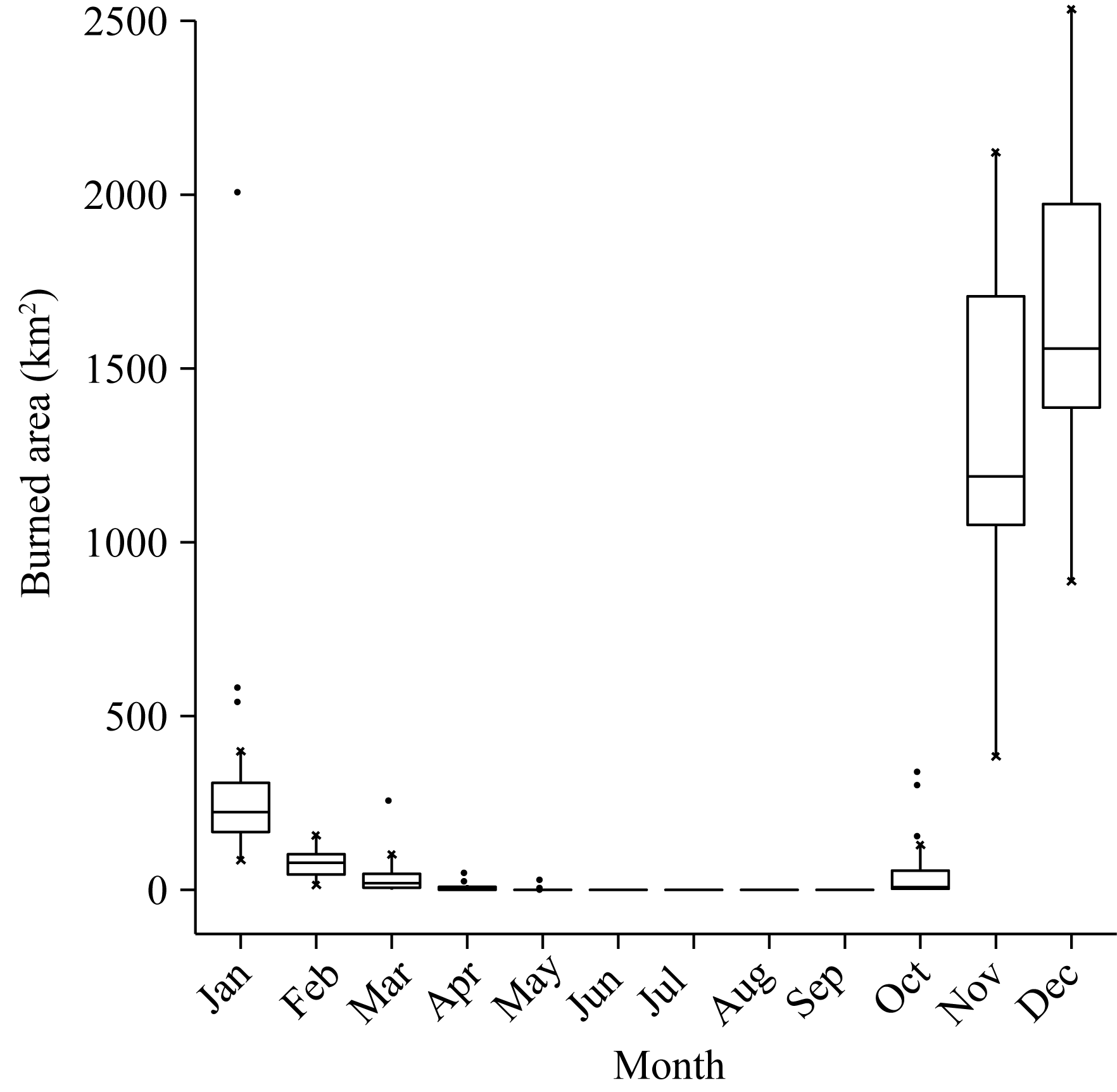
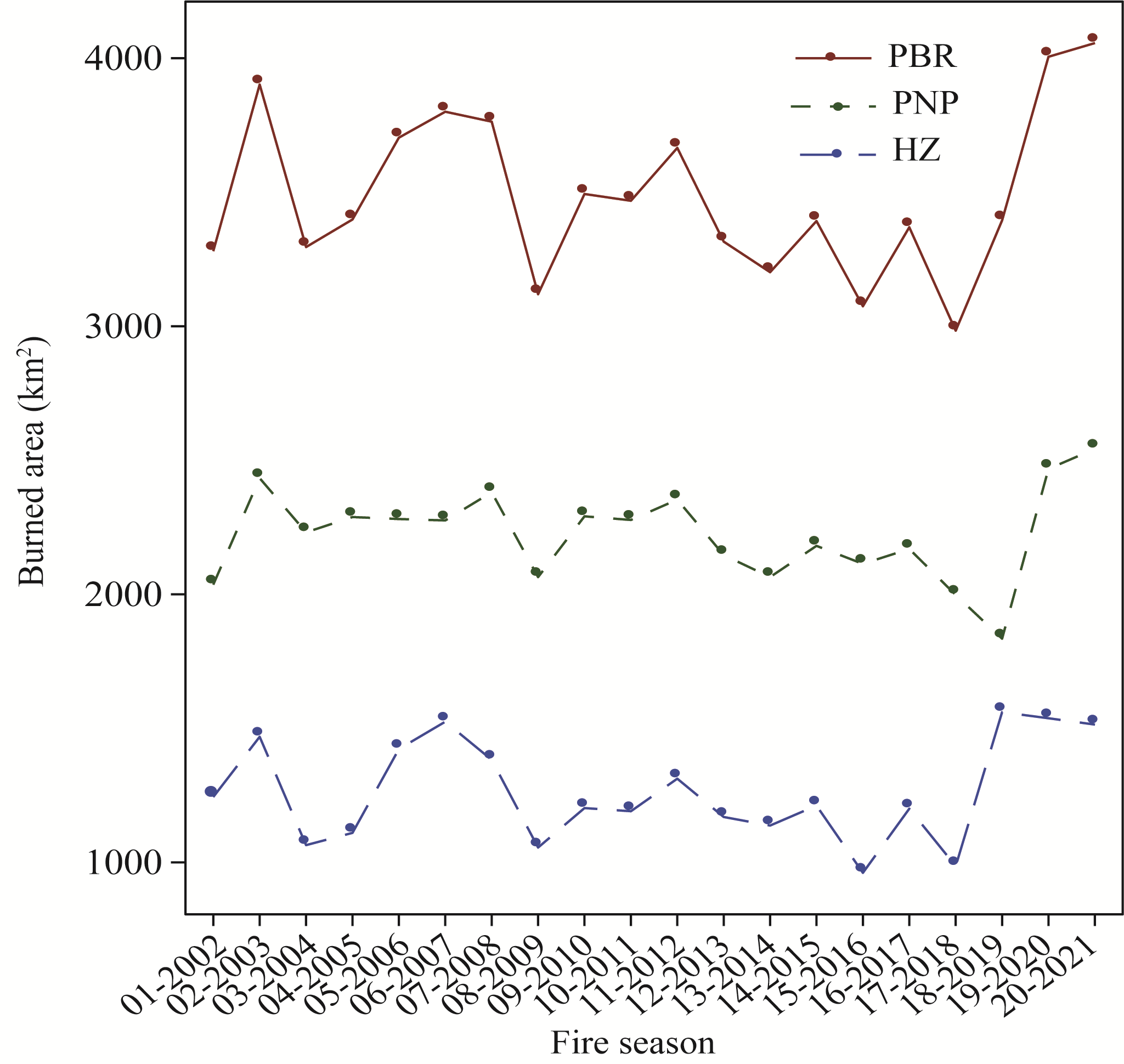
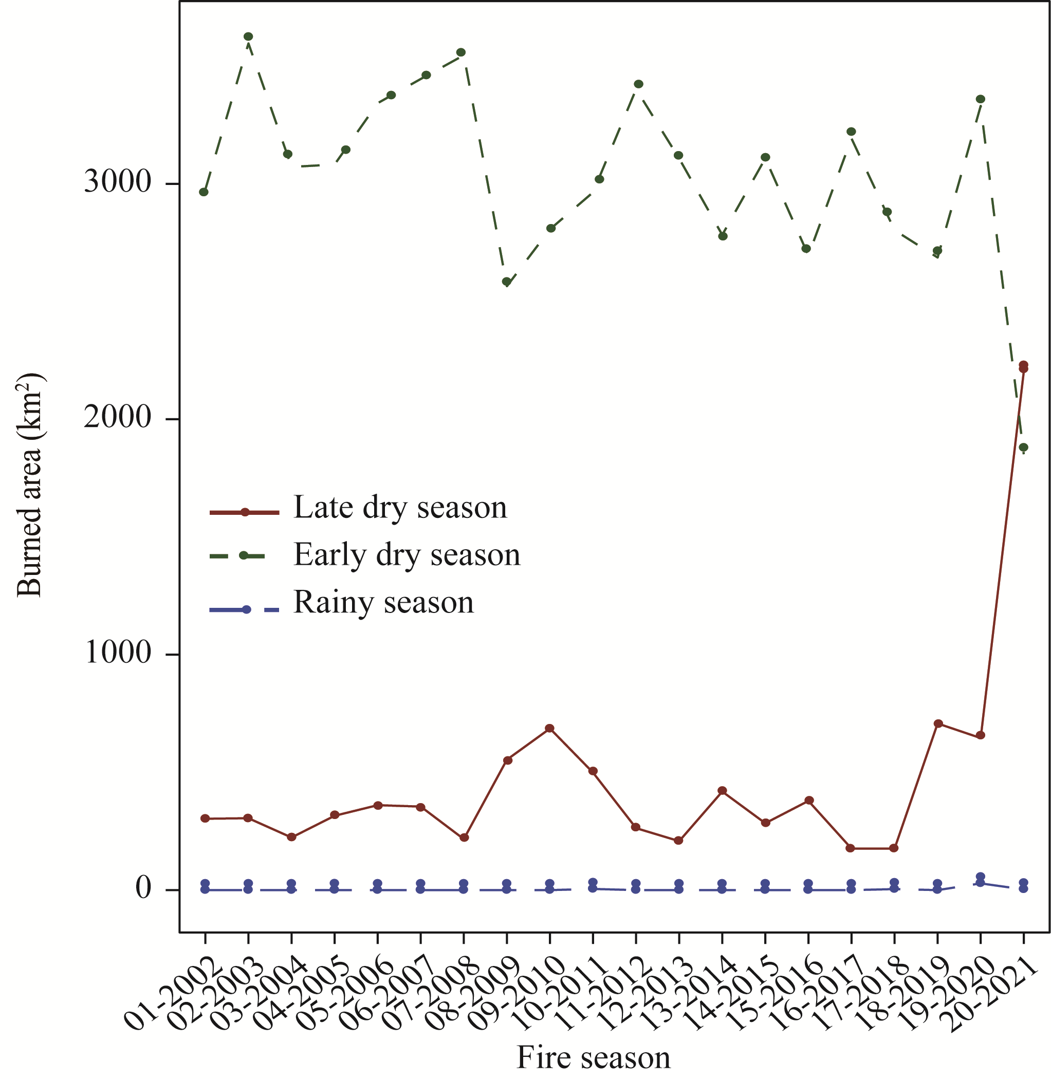
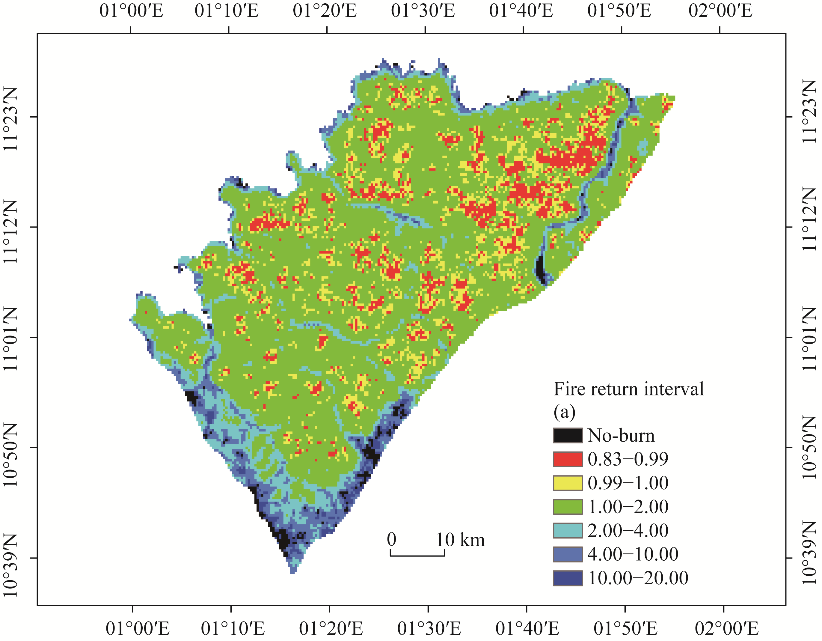
Abstract Pendjari Biosphere Reserve (PBR), a primary component of the W-Arly-Pendjari transboundary biosphere reserve, represents the largest intact wild ecosystem and pristine biodiversity spot in West Africa. This savannah ecosystem has long been affected by fire, which is the main ecological driver for the annual rhythm of life in the reserve. Understanding the fire distribution patterns will help to improve its management plan in the region. This study explores the fire regime in the PRB during 2001-2021 in terms of burned area, seasonality, fire frequency, and mean fire return interval (MFRI) by analysing moderate resolution imaging spectroradiometer (MODIS) burned area product. Results indicated that the fire season in the PBR extends from October to May with a peak in early dry season (November-December). The last two fire seasons (2019-2020 and 2020-2021) recorded the highest areas burned in the PBR out of the twenty fire seasons studied. During the twenty years period, 8.2% of the reserve burned every 10-11 months and 11.5% burned annually. The largest part of the reserve burned every one to two years (63.1%), while 8.3% burned every two to four years, 5.8% burned every four to ten years, and 1.9% burned every ten to twenty years. Only 1.3% of the entire area did not fire during the whole study period. Fire returned to a particular site every 1.39 a and the annual percentage of area burned in the PBR was 71.9%. The MFRI (MFRI<2.00 a) was low in grasslands, shrub savannah, tree savannah, woodland savannah, and rock vegetation. Fire regime must be maintained to preserve the integrity of the PBR. In this context, we suggest applying early fire in tree and woodland savannahs to lower grass height, and late dry season fires every two to three years in shrub savannah to limit the expansion of shrubs and bushes. We propose a laissez-faire system in areas in woodland savannah where the fire frequency is sufficient to allow tree growth. Our findings highlight the utility of remote sensing in defining the geographical and temporal patterns of fire in the PBR and could help to manage this important fire prone area.
|
|
Received: 25 May 2023
Published: 31 October 2023
|
|
Corresponding Authors:
*Omobayo G ZOFFOUN (E-mail: ghislainholy@gmail.com)
|
|
|
| [1] |
Agee J K. 1997. Fire management for the 21st century. In: Kohm K A, Franklin J F. Creating a Forestry for the 21st Century: The Science of Ecosystem Management. Washington DC: Island Press, 191-201.
|
|
|
| [2] |
Agee J K. 1998. The landscape ecology of western forest fire regimes. Northwest Science, 72: 24-34.
|
|
|
| [3] |
Archibald S, Nickless A, Govender N, et al. 2010a. Climate and the inter-annual variability of fire in southern Africa: A meta-analysis using long-term field data and satellite-derived burnt area data. Global Ecology and Biogeography, 19(6): 794-809.
doi: 10.1111/geb.2010.19.issue-6
|
|
|
| [4] |
Archibald S, Scholes R J, Roy D, et al. 2010b. Southern African fire regimes as revealed by remote sensing. International Journal of Wildland Fire, 19(7): 861-878.
doi: 10.1071/WF10008
|
|
|
| [5] |
Archibald S, Lehmann C E, Gómez-Dans J L, et al. 2013. Defining pyromes and global syndromes of fire regimes. Proceedings of the National Academy of Sciences, 110(16): 6442-6447.
|
|
|
| [6] |
Archibald S, Beckett H, Bond W J, et al. 2017. Interactions between fire and ecosystem processes. In: Cromsigt J P G M, Archibald S, Owen-Smith M. Conserving Africa's Mega-diversity in the Anthropocene. The Hluhluwe-iMfolozi Park Story. Cambridge: Cambridge University Press, 233-264.
|
|
|
| [7] |
Asgary A, Ghaffari A, Levy J. 2010. Spatial and temporal analyses of structural fire incidents and their causes: A case of Toronto, Canada. Fire Safety Journal, 45(1): 44-57.
doi: 10.1016/j.firesaf.2009.10.002
|
|
|
| [8] |
Bond W J, Archibald S. 2003. Confronting complexity: Fire policy choices in South African savanna parks. International Journal of Wildland Fire, 12(4): 381- 389.
doi: 10.1071/WF03024
|
|
|
| [9] |
Bond W J, Woodward F I, Midgley G F. 2005. The global distribution of ecosystems in a world without fire. New Phytologist, 165(2): 525-538.
pmid: 15720663
|
|
|
| [10] |
Bradstock R A. 2010. A biogeographic model of fire regimes in Australia: Current and future implications. Global Ecology and Biogeography, 19(2): 145-158.
doi: 10.1111/j.1466-8238.2009.00512.x
|
|
|
| [11] |
Cangela A. 2014. Mapping the burning regime (2000-2012) in the Niassa National Reserve. MSc Thesis. Maputo: Eduardo Mondlane University.
|
|
|
| [12] |
Chidumayo E N. 1997. Miombo Ecology and Management: An Introduction. Stockholm: Stockholm Environment Institute, 110.
|
|
|
| [13] |
Chuvieco E, Roteta E, Sali M, et al. 2022. Building a small fire database for sub-Saharan Africa from Sentinel-2 high-resolution images. Science of the total Environment, 845: 157139, doi: 10.1016/j.scitotenv.2022.157139.
|
|
|
| [14] |
Clerici N. 2006. Monitoring and assessing fire impacts and land-cover change in tropical and subtropical ecosystems using satellite remote sensing and GIS techniques. PhD Dissertation. Parma: Università degli Studi di Parma.
|
|
|
| [15] |
DeBano L F, Neary D G, Ffolliott P F. 1998. Fire's Effect on Ecosystems. New York: Wiley, 352.
|
|
|
| [16] |
Delvingt W, Heymans J C, Sinsin B. 1989. Pendjari National Park Guide. Bruxelles: CCE/Cellule de Prospective, 119.
|
|
|
| [17] |
Devineau J L. 1986. Ecological impact of the recolonization of Onchocerciasis-free areas in the Burkinabe valleys (Nazinon, Nakambé, Mouhoun, Bougouriba). Final report WHO, Ouagadougou, Burkina-Faso: ORSTOM. [2022-10-18]. https://hal.ird.fr/ird-00362434v1/document.
|
|
|
| [18] |
Devineau J L, Fournier A, Nignan S. 2010. Savanna fire regimes assessment with MODIS fire data: Their relationship to land cover and plant species distribution in western Burkina Faso (West Africa). Journal of Arid Environments, 74(9): 1092-1101.
doi: 10.1016/j.jaridenv.2010.03.009
|
|
|
| [19] |
Dolidon H. 2007. The multiplicity of scales in the analysis of a phenomenon at the nature/society interface. The example of bushfires in West Africa. Cybergeo, 363: 4805, doi: 10.4000/cybergeo.4805.
|
|
|
| [20] |
Eby S L, Anderson T M, Mayemba E P, et al. 2014. The effect of fire on habitat selection of mammalian herbivores: The role of body size and vegetation characteristics. Journal of Animal Ecology, 83(5): 1196-1205.
doi: 10.1111/1365-2656.12221
pmid: 24697568
|
|
|
| [21] |
Frost P. 1996. The ecology of Miombo woodlands. In: Campbell B. The Miombo in Transition: Woodlands and Welfare in Africa. Bogor: Center for International Forestry Research (CIFOR), 11-55.
|
|
|
| [22] |
Giglio L, Boschetti L, Roy D, et al. 2021. MODIS burned area product user's guide, version 1.0. [2022-12-21]. https://modis-land.gsfc.nasa.gov/burn.html.
|
|
|
| [23] |
Gnonlonfoun I, Kassa b, Azihou F, et al. 2019. Perceived effects of elephants (Loxodonta africana Cuvier) presence and impacts on ecosystem services supply in the Pendjari Biosphere Reserve, West Africa. Tropical Conservation Science, 12(1): 1-13.
|
|
|
| [24] |
Govender N, Trollope W, van Wilgen B. 2006. The effect of fire season, fire frequency, rainfall and management on fire intensity in savanna vegetation in South Africa. Journal of Applied Ecology, 43(4): 748-758.
doi: 10.1111/j.1365-2664.2006.01184.x
|
|
|
| [25] |
Gueguim C D, Tchamba N M, Fotso C R. 2018. Dynamic of spatial distribution of forest fire in the Mbam and Djerem Conservation Region (Cameroun). International Journal of Biological and Chemical Sciences, 12(2): 728-748. (in French)
doi: 10.4314/ijbcs.v12i2.10
|
|
|
| [26] |
Houehanou T D, Assédé E S P, Habiyaremye F M, et al. 2017. Pendjari Biosphere Reserve (Benin): Guide & Lexicon for Monitoring Natural Areas: Habitats, Fauna and Fires. Belgium: Royal Belgian Institute of Natural Sciences, 141.
|
|
|
| [27] |
Kasischke E S, Williams D, Barry D. 2002. Analysis of the patterns of large fires in the boreal forest region of Alaska. International Journal of Wildland Fire, 11(2): 131-144.
doi: 10.1071/WF02023
|
|
|
| [28] |
Keane R E. 2019. Fire ecology. In: Manzello S. Encyclopedia of Wildfires and Wildland-Urban Interface (WUI) Fires. Cham: Springer, 1-12.
|
|
|
| [29] |
Keeley J E, Rundel P W. 2005. Fire and the Miocene expansion of C4 grasslands. Ecology Letters, 8(7): 683-690.
doi: 10.1111/ele.2005.8.issue-7
|
|
|
| [30] |
Kodandapani N, Cochrane M A, Sukumar R. 2008. A comparative analysis of spatial, temporal, and ecological characteristics of forest fires in seasonally dry tropical ecosystems in the Western Ghats, India. Forest Ecology and Management, 256(4): 607-617.
doi: 10.1016/j.foreco.2008.05.006
|
|
|
| [31] |
Lawes M J, Adie H, Russell-Smith J, et al. 2011. How do small savanna trees avoid stem mortality by fire?. The roles of stem diameter, height and bark thickness. Ecosphere, 2(4): 1-13.
|
|
|
| [32] |
Lee B, Park P S, Chung J. 2006. Temporal and spatial characteristics of forest fires in South Korea between 1970 and 2003. International Journal of Wildland Fire, 15(3): 389-396.
doi: 10.1071/WF05090
|
|
|
| [33] |
Lehmann C E R, Archibald S A, Hoffmann W A, et al. 2011. Deciphering the distribution of the savanna biome. New Phytologist, 191(1): 197-209.
doi: 10.1111/j.1469-8137.2011.03689.x
pmid: 21463328
|
|
|
| [34] |
Lopes M, Frison P L, Durant S M, et al. 2020. Combining optical and radar satellite image time series to map natural vegetation: Savannas as an example. Remote Sensing in Ecology and Conservation, 6(3): 316-326.
doi: 10.1002/rse2.v6.3
|
|
|
| [35] |
Machado N G, da Silva F C P, Biudes M S. 2014. The effect of weather conditions on fire risk and the number of urban fires and hotspots in Cuiabá-MT, Brazil. Ciência Natura, 36(3): 459-469.
|
|
|
| [36] |
Mariki A. 2016. Addressing forest degradation in Miombo woodland through preventive community-based early burning in Tanzania. In: Ribeiro N S, Nhantumbo I, Nangoma D, et al. Miombo Network Meeting Report: Restoring Socio-ecological and Socio-economic Relationships in the Miombo Woodlands. Maputo: Universidade Eduardo Mondlane, 1-20.
|
|
|
| [37] |
Mathieu R, Main R, Roy D P, et al. 2019. The effect of surface fire in savannah systems in the Kruger National Park (KNP), South Africa, on the backscatter of C-band Sentinel-1 images. Fire, 2(3): 37, doi: 10.3390/fire2030037.
|
|
|
| [38] |
Menges C H, Bartolo R E, Bell D, et al. 2004. The effect of savanna fires on SAR backscatter in northern Australia. International Journal of Remote Sensing, 25(22): 4857-4871.
doi: 10.1080/01431160410001712945
|
|
|
| [39] |
Namukonde N, Kuebler D, Ganzhorn J U. 2017. Differential effects of fire on small mammal communities in the Busanga flood plain, Zambia. Tropical Conservation Science, 10: 1-13.
|
|
|
| [40] |
N'Dri A B, Gignoux J, Barot S, et al. 2014. The dynamics of hollowing in annually burnt savanna trees and its effect on adult tree mortality. Plant Ecology, 215: 27-37.
doi: 10.1007/s11258-013-0276-9
|
|
|
| [41] |
Nefabas L L, Gambiza J. 2007. Fire-tolerance mechanisms of common woody plant species in a semiarid savanna in south-western Zimbabwe. African Journal of Ecology, 45(4): 550-556.
doi: 10.1111/aje.2007.45.issue-4
|
|
|
| [42] |
Oliveira S L J, Turkman M A A, Pereira J M C. 2013. An analysis of fire frequency in tropical savannas of northern Australia, using a satellite-based fire atlas. International Journal of Wildland Fire, 22(4): 479-492.
doi: 10.1071/WF12021
|
|
|
| [43] |
Osborne C P. 2008. Atmosphere, ecology and evolution: What drove the Miocene expansion of C4 grasslands? Journal of Ecology, 96(1): 35-45.
doi: 10.1111/j.1365-2745.2007.01323.x
pmid: 18784799
|
|
|
| [44] |
Pereira Jũnior A C, Oliveira S L J, Pereira J M C, et al. 2014. Modelling fire frequency in a Cerrado savanna protected area. PLoS ONE, 9(7): e102380, doi:10.1371/journal.pone.0102380.
|
|
|
| [45] |
R Development Core Team. 2021. R: A Language and Environment for Statistical Computing. Vienna: R Foundation for Statistical Computing.
|
|
|
| [46] |
Reich P B, Peterson D W, Wedin D A, et al. 2001. Fire and vegetation effects on productivity and nitrogen cycling across a forest-grassland continuum. Ecology, 82(6): 1703-1719.
|
|
|
| [47] |
Ribeiro N S. 2007. Interactions between fires and elephants in relation to vegetation composition and structure of Miombo woodlands in northern Mozambique. PhD Dissertation. Charlottesville: University of Virginia.
|
|
|
| [48] |
Ribeiro N S, Shugart H H, Washington-Allen R. 2008. The effects of fire and elephants on species composition and structure of the Niassa Reserve, northern Mozambique. Forest Ecology and Management, 255(5-6): 1626-1636.
doi: 10.1016/j.foreco.2007.11.033
|
|
|
| [49] |
Ribeiro N S, Cangela A, Chauque A, et al. 2017. Characterization of spatial and temporal distribution of the fire regime in Niassa National Reserve, northern Mozambique. International Journal of Wildland Fire, 26(12): 1021-1029.
doi: 10.1071/WF17085
|
|
|
| [50] |
Roy D P, Boschetti L, Justice C O, et al. 2008. The collection 5 MODIS burned area product-Global evaluation by comparison with the MODIS active fire product. Remote Sensing of Environment, 112(9): 3690-3707.
doi: 10.1016/j.rse.2008.05.013
|
|
|
| [51] |
Santos J R. 1985. Automatic analysis of MSS/Landsat sensor data for the evaluation of burnt areas in the installation and conservation of agricultural projects. In: Final Report. IV Plenary Meeting SELPER. Santiago: Society of Latin American Specialists in Remote Sensing (SELPER), 95-102.
|
|
|
| [52] |
Scholes R J, Archer S R. 1997. Tree-grass interactions in savannas. Annual Review of Ecological Systematics, 28: 517-544.
doi: 10.1146/ecolsys.1997.28.issue-1
|
|
|
| [53] |
Scott A C, Bowman D M J S, Bond W J, et al. 2014. Fire on Earth: An Introduction. Chichester: Wiley, 434.
|
|
|
| [54] |
Setzer A W, Pereira M C, Pereira A C. 1994. Satellite studies of biomass burning in Amazonia-some practical aspects. Remote Sensing Reviews 10( 1-3): 91-103.
doi: 10.1080/02757259409532238
|
|
|
| [55] |
Shannon G, Thaker M, Vanak A T, et al. 2011. Relative impacts of elephant and fire on large trees in a savanna ecosystem. Ecosystems, 14: 1372-1381.
doi: 10.1007/s10021-011-9485-z
|
|
|
| [56] |
Silva P S, Bastos A, Libonati R, et al. 2019. Impacts of the 1.5°C global warming target on future burned area in the Brazilian Cerrado. Forest Ecology and Management 446: 193-203.
doi: 10.1016/j.foreco.2019.05.047
|
|
|
| [57] |
Smith A M S, Wooster M J. 2005. Remote classification of head and backfire types from MODIS fire radiative power and smoke plume observations. International Journal of Wildland Fire, 14(3): 249-254.
doi: 10.1071/WF05012
|
|
|
| [58] |
Sogbohossou E A, de Iongh H H, Sinsin B, et al. 2011. Human carnivore conflict around Pendjari Biosphere Reserve, northern Benin. Oryx, 45(4): 569-578.
doi: 10.1017/S0030605310001109
|
|
|
| [59] |
Stellmes M, Frantz D, Finckh M, et al. 2013. Fire frequency, fire seasonality, and fire intensity within the Okavango region derived from MODIS fire products. Biodiversity & Ecology, 5: 351-362.
|
|
|
| [60] |
Takacs S, Buhne H S, Pettorelli N. 2021. What shapes fire size and spread in African savannahs? Remote Sensing in Ecology and Conservation, 7(4): 610-620.
doi: 10.1002/rse2.v7.4
|
|
|
| [61] |
Tarimo B, Dick Ø B, Gobakken T, et al. 2015. Spatial distribution of temporal dynamics in anthropogenic fires in Miombo savanna woodlands of Tanzania. Carbon Balance and Management, 10: 18, doi: 10.1186/s13021-015-0029-2.
pmid: 26246851
|
|
|
| [62] |
Ullah M R, Liu X D, Al-Amin M. 2013. Spatial-temporal distribution of forest fires and fire weather index calculation from 2000 to 2009 in China. Journal of Forest Science, 59(7): 279-287.
doi: 10.17221/8/2013-JFS
|
|
|
| [63] |
Wittenberg L, Malkinson D. 2009. Spatio-temporal perspectives of forest fires regimes in a maturing Mediterranean mixed pine landscape. European Journal of Forest Research, 128: 297-304.
doi: 10.1007/s10342-009-0265-7
|
|
|
|
Viewed |
|
|
|
Full text
|
|
|
|
|
Abstract
|
|
|
|
|
Cited |
|
|
|
|
| |
Shared |
|
|
|
|
| |
Discussed |
|
|
|
|