| Research article |
|

|
|
|
| A study on historical location and evolution of Lop Nor in China with maps and DEM |
ZHANG Tingting1,2, SHAO Yun1,2,*( ), GENG Yuyang1,3, GONG Huaze1, YANG Lan4 ), GENG Yuyang1,3, GONG Huaze1, YANG Lan4 |
1Laboratory of Target Microwave Properties, Deqing Academy of Satellite Applications, Deqing 313200, China
2Aerospace Information Research Institute, Chinese Academy of Sciences, Beijing 100094, China
3University of Chinese Academy of Science, Beijing 100049, China
4China University of Geosciences, Beijing100083, China |
|
|
|
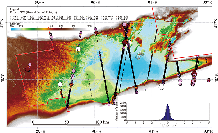
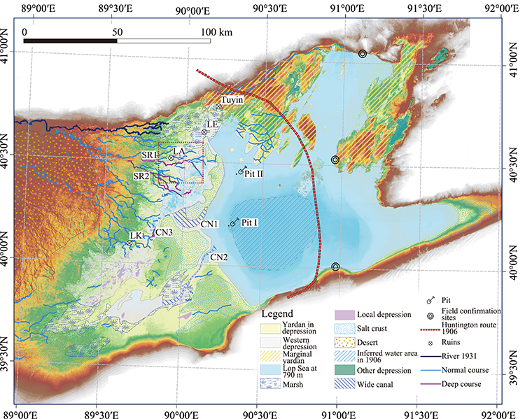
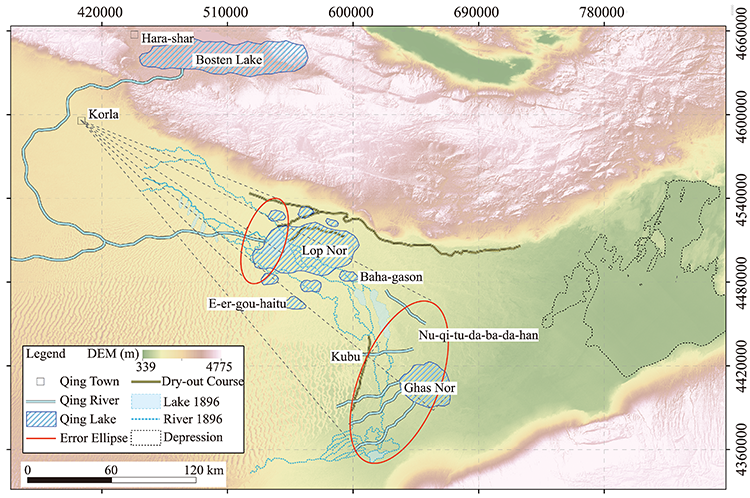
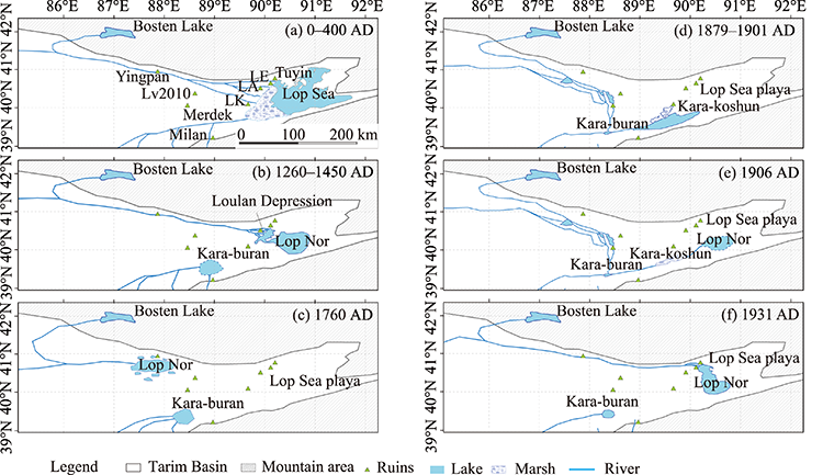
Abstract Lop Sea, located at the east end of the Tarim Basin, Northwest China, dried up permanently, which is the terminal lake of the Tarim River. Lop Sea was considered as the lake basin of Lop Nor since Quaternary. However, the possibility that Lop Nor was away from the Lop Sea in historical time is crucial to be discussed to interpret the proxy records in sediment profiles. To obtain a general view of the evolution of Lop Nor and Lop Sea in a historical period, several approaches were adopted in this paper. First, the Qianlong Thirteen-Row Atlas, an ancient imperial atlas of the Qing Dynasty, which was completed around 1760, indicated that the Tarim River formed a relatively large lake at its modern upstream region. Second, a Digital Elevation Model (DEM) with a 10-m spatial resolution and a relative precision of 0.42 m was derived from TanDEM-X/TerraSAR-X satellite image pairs using the interferometry method, which was verified using ICESat-GLAS laser footprints and a local DEM acquired by a drone. Finally, based on the spatial analysis of historical documents, expedition reports, sediment profiles and archaeological evidence, it can be deduced that the lacustrine deposition was discontinued in the Lop Sea. Six episodes in the evolutionary history of the drainage system in eastern Tarim Basin were summarized. The proved depositional condition variations could be used for future interpretation of proxy records in sediment. The high-accurate DEM provided a reference for the location of further fieldwork in the Lop Sea. The method proposed in this paper may be efficient for the research of inland lakes or rivers in global arid regions.
|
|
Received: 21 September 2020
Published: 10 June 2021
|
|
Corresponding Authors:
|
About author: SHAO Yun (E-mail: shaoyun@radi.ac.cn)
|
|
|
| [1] |
Abdimijit A, Alimujiang K, Alishir K, et al. 2014. Monitoring the water area changes in Tetima-Kanglayka Lakes region over the past four decades by remotely sensed data. Journal of Lake Sciences, 26(1):46-54. (in Chinese)
doi: 10.18307/2014.0106
|
|
|
| [2] |
Abdimijit A, Alimujiang K, Alishir K, et al. 2016. Evolution of small lakes in lower reaches of Tarim River based on multi-source spatial data. Geographical Research, 35(11):2071-2090. (in Chinese)
|
|
|
| [3] |
Chen F, Yu Z, Yang M, et al. 2008. Holocene moisture evolution in arid central Asia and its out-of-phase relationship with Asian monsoon history. Quaternary Science Reviews, 27(3-4):351-364.
doi: 10.1016/j.quascirev.2007.10.017
|
|
|
| [4] |
Chen P C. 1936. Lop Nor and Lop Desert. Acta Geographica Sinica, 1:19-49. (in Chinese)
|
|
|
| [5] |
Coianiz L, Ariztegui D, Piovano E L, et al. 2015. Environmental change in subtropical South America for the last two millennia as shown by lacustrine pigments. Journal of Paleolimnology, 53:233-250.
doi: 10.1007/s10933-014-9822-2
|
|
|
| [6] |
Dong Z, Lv P, Qian G, et al. 2012. Research progress in China's Lop Nur. Earth Science Reviews, 111(1-2):142-153.
doi: 10.1016/j.earscirev.2011.11.003
|
|
|
| [7] |
Fritz T, Balss U, Bamler R, et al. 2012. Phase unwrapping correction with dual-baseline data for the TanDEM-X mission. Geoscience and Remote Sensing Symposium, 5566-5569.
|
|
|
| [8] |
González J H, Bachmann M, Scheiber R, et al. 2010. Definition of ICESat selection criteria for their use as height references for TanDEM-X. IEEE Transactions on Geoscience and Remote Sensing, 48(6):2750-2757.
doi: 10.1109/TGRS.2010.2041355
|
|
|
| [9] |
Guo S, Li D. 2003. A survey of Felix da Rocha's scientific work in China. Palace Museum Journal, 4:005. (in Chinese)
|
|
|
| [10] |
Guo S, Li D. 2005. P. José de Espinha, imperial first supervisor in charge of the Western Affairs and Astronomy. Journal of Inner Mongolia Normal University (Philosophy and Social Science), 2:008. (in Chinese)
|
|
|
| [11] |
Han C, Lv G. 2006. The changes of Lopliks living in the east of the Tarim Basin and their environment since the Qing Dynasty. Journal of Chinese Historical Geography, 21(2):60-66. (in Chinese)
|
|
|
| [12] |
Hedin S. 1905. Scientific results of a journey in central Asia, 1899-1902 Vol. 2 Lop Nur. Lithographic institute of the General staff of the Swedish army, 257-369.
|
|
|
| [13] |
Hedin S. 1940. The Wandering Lake. New York: E P Dutton and Company Inc., 80-112.
|
|
|
| [14] |
Hörner N G, Chen P C. 1935. Alternating lakes. Some river changes and lake displacements in central Asia. Geografiska Annaler, 17:145-166.
|
|
|
| [15] |
Huntington E. 1907a. Lop-Nor. A Chinese lake. Part I. The unexplored salt desert of Lop. Bulletin of the American Geographical Society, 39:65-77.
doi: 10.2307/198379
|
|
|
| [16] |
Huntington E. 1907b. Lop-Nor. A Chinese lake. Part II. The historic lake (Lop-Nor). Bulletin of the American Geographical Society, 39(3):137-146.
doi: 10.2307/198273
|
|
|
| [17] |
Ivory S J, Russell J. 2018. Lowland forest collapse and early human impacts at the end of the African Humid Period at Lake Edward, equatorial East Africa. Quaternary Research, 89(1):7-20.
doi: 10.1017/qua.2017.48
|
|
|
| [18] |
Jia H, Liu J, Qin X. 2011. Early Holocene climate changes and agricultural activities inferred from spore-pollen of Lop Nur. Journal of Jilin University (Science Edition), 41:181-194. (in Chinese)
|
|
|
| [19] |
Jiang H, Shevenell A, Yu S, et al. 2015. Decadal-to centennial-scale East Asian summer monsoon variability during the Medieval Climate Anomaly reconstructed from an eastern Tibet lacustrine sequence. Journal of Paleolimnology, 54:205-222.
doi: 10.1007/s10933-015-9847-1
|
|
|
| [20] |
Li B, Ma L, Jiang P, et al. 2008. High precision topographic data on Lop Nor basin's lake "Great Ear" and the timing of its becoming a dry salt lake. Chinese Science Bulletin, 53:905-914.
|
|
|
| [21] |
Li G, Tang X, Zhang C, et al. 2017. Multi-criteria constraint algorithm for selecting ICESat/GLAS data as elevation control points. Journal of Remote Sensing, 21:96-104. (in Chinese)
|
|
|
| [22] |
Li K, Qin X, Zhang L, et al. 2018. Hydrological change and human activity during Yuan-Ming Dynasties in the Loulan area, northwestern China. Holocene, 28(8):1266-1275.
doi: 10.1177/0959683618771495
|
|
|
| [23] |
Liu C, Zhang J F, Jiao P, et al. 2016. The Holocene history of Lop Nur and its palaeoclimate implications. Quaternary Science Reviews, 148:163-175.
doi: 10.1016/j.quascirev.2016.07.016
|
|
|
| [24] |
Lu Z. 2008. Folk maps of Qing Dynasty. Land and Resources, 12:58-61. (in Chinese)
|
|
|
| [25] |
Lucieer A, de Jong S M, Turner D. 2014a. Mapping landslide displacements using Structure from Motion (SfM) and image correlation of multi-temporal UAV photography. Progress in Physical Geography, 38(1):97-116.
|
|
|
| [26] |
Lucieer A, Turner D, King D H, et al. 2014b. Using an Unmanned Aerial Vehicle (UAV) to capture micro-topography of Antarctic moss beds. International Journal of Applied Earth Observation and Geoinformation, 27:53-62.
doi: 10.1016/j.jag.2013.05.011
|
|
|
| [27] |
Lv H, Xia X, Liu J. 2010. A preliminary study of chronology for a newly-discovered ancient city and five archaeological sites in Lop Nor. Chinese Scientific Bulletin, 55:237-245. (in Chinese)
|
|
|
| [28] |
Ma C M, Wang F B, Cao Q Y, et al. 2008. Climate and environment reconstruction during the Medieval Warm Period in Lop Nur of Xinjiang, China. Chinese Science Bulletin, 53:3016-3027.
|
|
|
| [29] |
Mancini F, Dubbini M, Gattelli M, et al. 2013. Using unmanned aerial vehicles (UAV) for high-resolution reconstruction of topography: The structure from motion approach on coastal environments. Remote Sensing, 5(12):6880-6898.
doi: 10.3390/rs5126880
|
|
|
| [30] |
Mischke S, Liu C, Zhang J, et al. 2017. The world's earliest Aral-Sea type disaster: the decline of the Loulan Kingdom in the Tarim Basin. Scientific Reports, 7:43102, doi: 10.1038/srep43102.
doi: 10.1038/srep43102
|
|
|
| [31] |
Mischke S, Liu C, Zhang J. 2020. Lop Nur in NW China: Its natural state, and a long history of human impact. In: Kalweit S I. Large Asian Lakes in Changing World. Berlin: Springer, 207-233.
|
|
|
| [32] |
Pavlis N K, Holmes S A, Kenyon S C, et al. 2008. An earth gravitational model to degree 2160: EGM2008. EGU General Assembly, 10:13-18.
|
|
|
| [33] |
Pavlis N K, Holmes S A, Kenyon S C, et al. 2012. The development and evaluation of the Earth Gravitational Model 2008 (EGM2008). Journal of Geophysical Research: Solid Earth, 117, doi: 10.1029/2011JB008916.
doi: 10.1029/2011JB008916
|
|
|
| [34] |
Pjevtsoff M V, Tong Y, Tong S trans. 2013. The Expedition of Pjevtsoff. Urumqi: Xinjiang People Press. (in Chinese)
|
|
|
| [35] |
Przhevalsky N, Huang J (trans.). 1999. Moving toward Lop Nor. Urumqi: Xinjiang People Press. (in Chinese)
|
|
|
| [36] |
Reinhardt C, Wünnemann B, Krivonogov S K. 2008. Geomorphological evidence for the Late Holocene evolution and the Holocene lake level maximum of the Aral Sea. Geomorphology, 93(3-4):302-315.
doi: 10.1016/j.geomorph.2007.03.002
|
|
|
| [37] |
Shao Y, Gong H, Liu C. 2011. Primary interpretation on shorelines of vanished Lop Nur Lake using multi-source SAR data. Journal of Remote Sensing, 15:645-647. (in Chinese)
|
|
|
| [38] |
Shao Y, Gong H, Gao Z, et al. 2012. SAR data for subsurface saline lacustrine deposits detection and primary interpretation on the evolution of the vanished Lop Nur Lake. Canadian Journal of Remote Sensing, 38(3):267-280.
doi: 10.5589/m12-019
|
|
|
| [39] |
Stein A. 1921. Serindia: Detailed Report of Explorations in Central Asia and Westernmost China. Oxford: Clarendon Press, 50-56.
|
|
|
| [40] |
Sun Y, Jiang L, Liu L, et al. 2016. Generating and evaluating digital terrain model with TanDEM-X bistatic SAR interferometry. Geomatics and Information Science of Wuhan University, 41:100-105. (in Chinese)
|
|
|
| [41] |
Wallace L, Lucieer A, Malenovský Z, et al. 2016. Assessment of forest structure using two UAV techniques: a comparison of airborne laser scanning and structure from motion (SfM) point clouds. Forests, 7(3):62.
doi: 10.3390/f7030062
|
|
|
| [42] |
Wang Q, Liu R. 2007. Three Surveyed Atlas of Qing Dynasty. Beijing: Foreign Languages Press. (in Chinese)
|
|
|
| [43] |
Xi G. 1992. Migration history of Lop Nor and new findings. The Western Regions Studies, 4:5-16. (in Chinese)
|
|
|
| [44] |
Xia X, Wang F, Zhao Y. 2007. Lop Nur in China. Beijing: Science Press, 1-27. (in Chinese)
|
|
|
| [45] |
Xu B, Gu Z, Qin X, et al. 2017. Radiocarbon dating the ancient city of Loulan. Radiocarbon, 59(4):1215-1226.
doi: 10.1017/RDC.2017.21
|
|
|
| [46] |
Xu H, Ye M, Song Y. 2005. The dynamic variation of water resources and its tendency in the Tarim River Basin. Acta Geographica Sinica, 15:467-474. (in Chinese)
|
|
|
| [47] |
Yang X, Liu Z, Zhang F, et al. 2006. Hydrological changes and land degradation in the southern and eastern Tarim Basin, Xinjiang, China. Land Degradation and Development, 17(4):381-392.
doi: 10.1002/(ISSN)1099-145X
|
|
|
| [48] |
Yuan G, Yuan L. 1998. An approach to the envionmental changes in Lop-Nur history. Acta Geographica Sinica, 53:80-89. (in Chinese)
|
|
|
| [49] |
Zhang J, Wang J, Ma H, et al. 2008. Streamflow variations of four source streams to mainstream of Tarim River, Xinjiang and water transportation in 2006. Journal of Glaciology and Geocryology, 30:569-577. (in Chinese)
|
|
|
| [50] |
Zhang J F, Liu C L, Wu X H, et al. 2012. Optically stimulated luminescence and radiocarbon dating of sediments from Lop Nur (Lop Nor), China. Quaternary Geochronology, 10:150-155.
doi: 10.1016/j.quageo.2011.12.001
|
|
|
| [51] |
Zhou Y. 1978. Discussion on the issue of Lop Nor migration. Journal of Beijing Normal University (Natural Science), 3:34-40. (in Chinese)
|
|
|
|
Viewed |
|
|
|
Full text
|
|
|
|
|
Abstract
|
|
|
|
|
Cited |
|
|
|
|
| |
Shared |
|
|
|
|
| |
Discussed |
|
|
|
|