| Research article |
|


|
|
|
| Estimation of aboveground biomass of arboreal species in the semi-arid region of Brazil using SAR (synthetic aperture radar) images |
Janisson B de JESUS1( ), Tatiana M KUPLICH2, Íkaro D de C BARRETO3, Fernando L HILLEBRAND4, Cristiano N da ROSA5 ), Tatiana M KUPLICH2, Íkaro D de C BARRETO3, Fernando L HILLEBRAND4, Cristiano N da ROSA5 |
1Postgraduate Program in Remote Sensing, Federal University of Rio Grande do Sul, Campus Vale, Porto Alegre 91501970, Brazil
2National Institute for Space Research (INPE), COESU (Southern Spatial Coordination), Santa Maria 97105970, Brazil
3Postgraduate Program Biometry and Applied Statistics, Rural Federal University of Pernambuco, Recife 52171900, Brazil
4Federal Institute of Education, Science and Technology of Rio Grande do Sul (IFRS), Campus Rolante, Rolante 95690000, Brazil
5Postgraduate Program in Remote Sensing, Polar and Climate Center, Federal University of Rio Grande do Sul, Porto Alegre 91501970, Brazil |
|
|
|
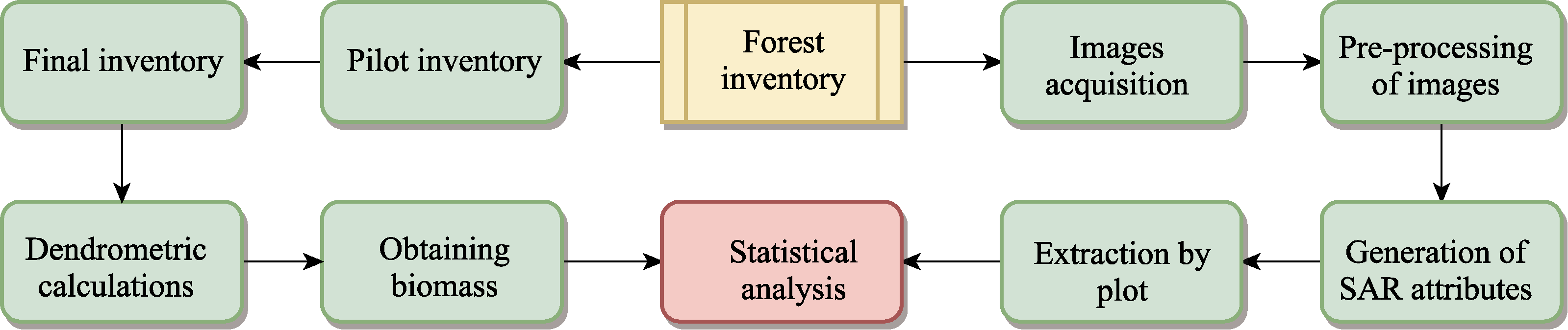
Abstract The Caatinga biome is an important ecosystem in the semi-arid region of Brazil. It has significantly degraded due to human activities and is currently a region undergoing desertification. Thus, monitoring the variation in the Caatinga biome has become essential for its sustainable development. However, traditional methods for estimating aboveground biomass (AGB) are time-consuming and destructive. Remote sensing, such as optical and radar imaging, can estimate and correlate with vegetation. Nevertheless, radar imaging is still a novelty to be applied in estimating the AGB of this biome, which is an area with little research. Therefore, this study aimed to use Sentinel-1 images to estimate the AGB of the Caatinga biome in Sergipe State (northeastern Brazil) and to verify its influencing factors. Nineteen sample plots (30 m×30 m) were selected, and the stems of individuals with a circumference at breast height (1.3 m above the ground) equal to or greater than 6.0 cm were measured, and the AGB through an allometric equation was estimated. The Sentinel-1 images from 3 different periods (green, intermediate, and dry periods) were used to consider the phenological conditions of the Caatinga biome. All the pre-processing and extraction of attributes (co-polarized VV (vertical transmit and vertical receive), cross-polarized VH (vertical transmit and horizontal receive), and band ratio VH/VV backscatter, radar vegetation index, dual polarization synthetic aperture radar (SAR) vegetation index (DPSVI), entropy (H), and alpha angle (α)) were performed with Sentinel's Application Platform. These attributes were used to estimate the AGB through simple and multiple linear regressions and evaluated by the coefficients of determination (R2), correlation (r), and root mean squared error (RMSE). The results showed that the attributes individually had little ability to estimate the AGB of the Caatinga biome in the three periods. Combined with multiple regression, we found that the intermediate period presented the equation with the best results among the observed and estimated variables (R2=0.73; r=0.85; RMSE=8.33 Mg/hm2), followed by the greenness period (R2=0.72; r=0.85; RMSE=8.40 Mg/hm2). The attributes contributing to these equations were VH/VV, DPSVI, H, α, and co-polarized VV for the green period and cross-polarized VH for the intermediate period. The study showed that the Sentinel-1 images could be used to estimate the AGB of the Caatinga biome in the green and intermediate phenological periods since the SAR attributes highly correlated with the estimated variable (i.e., AGB) through multiple linear equations.
|
|
Received: 04 November 2022
Published: 30 June 2023
|
|
Corresponding Authors:
* Janisson B de JESUS (E-mail: janisson.eng@gmail.com)
|
|
|
| [1] |
Akhtar A M, Qazi W A, Ahmad S R, et al. 2020. Integration of high-resolution optical and SAR satellite remote sensing datasets for aboveground biomass estimation in subtropical pine forest, Pakistan. Environmental Monitoring and Assessment, 192: 584.
doi: 10.1007/s10661-020-08546-1
pmid: 32808098
|
|
|
| [2] |
Althoff T D, Menezes R S C, Carvalho A L, et al. 2016. Climate change impacts on the sustainability of the firewood harvest and vegetation and soil carbon stocks in a tropical dry forest in Santa Teresinha Municipality, Northeast Brazil. Forest Ecology and Management, 360: 367-375.
doi: 10.1016/j.foreco.2015.10.001
|
|
|
| [3] |
Alvares C A, Stape J L, Sentelhas P C, et al. 2014. Köppen's climate classification map for Brazil. Meteorologische Zeitschrift, 22(6): 711-728.
doi: 10.1127/0941-2948/2013/0507
|
|
|
| [4] |
Baccini A, Friedl M A, Woodcock C E, et al. 2004. Forest biomass estimation over regional scales using multisource data. Geophysical Research Letters, 31(10): L10501, doi: 10.1029/2004GL019782.
doi: 10.1029/2004GL019782
|
|
|
| [5] |
Baccini A, Goetz S J, Walker W S, et al. 2012. Estimated carbon dioxide emissions from tropical deforestation improved by carbon-density maps. Nature Climate Change, 2: 182-185.
doi: 10.1038/nclimate1354
|
|
|
| [6] |
Bao N, Li W, Gu X, et al. 2019. Biomass estimation for semiarid vegetation and mine rehabilitation using Worldview-3 and Sentinel-1 SAR imagery. Remote Sensing, 11(23): 2855, doi: 10.3390/rs11232855.
doi: 10.3390/rs11232855
|
|
|
| [7] |
Barbosa Neto M V B, Araújo M S B, Araújo Filho J C, et al. 2021. Rill and sheet soil erosion estimation in an area undergoing desertification in the Brazilian semi‑arid region. Modeling Earth Systems and Environment, 7: 1183-1191.
doi: 10.1007/s40808-020-01026-y
|
|
|
| [8] |
Bastin J F, Berrahmouni N, Grainger A, et al. 2017. The extent of forest in dryland biomes. Science, 356(6338): 635-638.
doi: 10.1126/science.aam6527
|
|
|
| [9] |
Bezerra F G S, Aguiar A P D, Alvalá R C S, et al. 2020. Analysis of areas undergoing desertification, using EVI2 multi-temporal data based on MODIS imagery as indicator. Ecological Indicators, 117: 106579, doi: 10.1016/j.ecolind.2020.106579.
doi: 10.1016/j.ecolind.2020.106579
|
|
|
| [10] |
Braun A, Wagner J, Hochschild V. 2018. Above-ground biomass estimates based on active and passive microwave sensor imagery in low-biomass savanna ecosystems. Journal of Applied Remote Sensing, 12(4): 046027, doi: 10.1117/1.JRS.12.046027.
doi: 10.1117/1.JRS.12.046027
|
|
|
| [11] |
Cartus O, Santoro M, Wegmüller U, et al. 2021. Sentinel-1 coherence for mapping above-ground biomass in semiarid forest areas. IEEE Geoscience and Remote Sensing Letters, 19: 4012805, doi: 10.1109/LGRS.2021.4012805.
doi: 10.1109/LGRS.2021.4012805
|
|
|
| [12] |
Castanho A D A, Coe M T, Brando P, et al. 2020a. Potential shifts in the aboveground biomass and physiognomy of a seasonally dry tropical forest in a changing climate. Environmental Research Letters, 15(3): 034053, doi: 10.1088/1748-9326/ab7394.
doi: 10.1088/1748-9326/ab7394
|
|
|
| [13] |
Castanho A D A, Coe M T, Andrade E M, et al. 2020b. A close look at above ground biomass of a large and heterogeneous seasonally dry tropical forest-Caatinga in North East of Brazil. Annals of the Brazilian Academy of Sciences, 92(1): e20190282, doi: 10.1590/0001-3765202020190282.
doi: 10.1590/0001-3765202020190282
|
|
|
| [14] |
David R M, Rosser N J, Donoghue D N M. 2022. Improving above ground biomass estimates of Southern Africa dryland forests by combining Sentinel-1 SAR and Sentinel-2 multispectral imagery. Remote Sensing of Environment, 282: 113232, doi: 10.1016/j.rse.2022.113232.
doi: 10.1016/j.rse.2022.113232
|
|
|
| [15] |
Embrapa (Brazilian Agricultural Research Corporation). 2011. Brazilian system of soil classification. Brazilian soils. Soil map of Brazil. [2021-01-11]. https://wwwembrapabr/tema-solos-brasileiros/solos-do-brasil. (in Portuguese)
|
|
|
| [16] |
Embrapa (Brazilian Agricultural Research Corporation). 2018. SATVeg. Vegetation Temporal Analysis System. [2021-01-10]. https://wwwsatvegcnptiaembrapabr/satveg/loginhtml. (in Portuguese)
|
|
|
| [17] |
Emdagro. 2020. Agricultural Development Company of Sergipe. Statistic Agriculture. Rainfall. [2021-01-10]. https://wwwemdagrosegovbr/pluviosidade/. (in Portuguese)
|
|
|
| [18] |
ESA (European Space Agency). 2020a. Copernicus. Open Access Hub. [2021-10-14]. https://scihubcopernicuseu/dhus/#/home.
|
|
|
| [19] |
ESA (European Space Agency). 2020b. SNAP. [2021-11-18]. https://stepesaint/main/download/snap-download/.
|
|
|
| [20] |
FAO (Food and Agriculture Organization of the United Nations). 2012. Global Ecological Zones for FAO Forest Reporting: 2010 Update. Rome: Forest Resources Assessment Working, 52.
|
|
|
| [21] |
Fernandes M R M. 2018. Estimation of basal area, volume and biomass in a fragment of Caatinga dense hyperxerophile in the high Sergipe sertão based on data MSI/Sentinel-2. PhD Dissertation. Espírito Santo: Federal University of Espírito Santo. (in Portuguese)
|
|
|
| [22] |
Filipponi F. 2019. Sentinel-1 GRD preprocessing workflow. Proceedings, 18(1): 11, doi: 10.3390/ECRS-3-06201.
doi: 10.3390/ECRS-3-06201
|
|
|
| [23] |
Forkuor G, Zoungrana J-B B, Dimobe K, et al. 2020. Above-ground biomass mapping in West African dryland forest using Sentinel-1 and 2 datasets-A case study. Remote Sensing of Environment, 236: 111496, doi: 10.1016/j.rse.2019.111496.
doi: 10.1016/j.rse.2019.111496
|
|
|
| [24] |
Ghosh S M, Behera M D. 2021. Aboveground biomass estimates of tropical mangrove forest using Sentinel-1 SAR coherence data-the superiority of deep learning over a semi-empirical model. Computers & Geosciences, 150: 104737, doi: 10.1016/j.cageo.2021.104737.
doi: 10.1016/j.cageo.2021.104737
|
|
|
| [25] |
Huang X, Ziniti B, Torbick N, et al. 2018. Assessment of forest above ground biomass estimation using multi-temporal C-band Sentinel-1 and polarimetric L-band PALSAR-2 data. Remote Sensing, 10(9): 1424, doi: 10.3390/rs10091424.
doi: 10.3390/rs10091424
|
|
|
| [26] |
INSA (Semi Arid National Institute). 2019. Global Network of Dryland Research Institute. [2021-03-22]. https://www.gndri.org/institutions/semi-arid-national-institute-instituto-nacional-do-semiarido-insa/. (in Portuguese)
|
|
|
| [27] |
Jesus J B, Souza B B, Oliveira A M S, et al. 2019a. Aridity index and climatic risk of desertification in the semi-arid state of Sergipe. Brazilian Journal of Climatology, 24: 214-227.
|
|
|
| [28] |
Jesus J B, Ribeiro M M, Kuplich T M, et al. 2019b. Statistical analysis of the spatial relationship of Caatinga and physiographic factors through remote data. Revista Floresta, 49(4): 755-762.
|
|
|
| [29] |
Jesus J B, Kuplich T M, Barreto I D C, et al. 2021. Temporal and phenological profiles of open and dense Caatinga using remote sensing: Response to precipitation and its irregularities. Journal of Forestry Research, 32: 1067-1076.
doi: 10.1007/s11676-020-01145-3
|
|
|
| [30] |
Jesus J B, Oliveira D G, Araújo W S, et al. 2022. Influence of anthropization on the floristic composition and phytosociology of the Caatinga susceptible to desertification in the state of Sergipe, Brazil. Tropical Ecology, 63: 398-408.
doi: 10.1007/s42965-021-00201-1
|
|
|
| [31] |
Jesus J B, Kuplich T M, Barreto I D C, et al. 2023. Dual polarimetric decomposition in Sentinel-1 images to estimate aboveground biomass of arboreal caatinga. Remote Sensing Applications: Society and Environment, 29: 100897, doi: 10.1016/j.rsase.2022.100897.
doi: 10.1016/j.rsase.2022.100897
|
|
|
| [32] |
Kim Y, van Zyl J. 2004. Vegetation effects on soil moisture estimation. In:Proceedings of the International Geoscience and Remote Sensing Symposium. IEEE International Geoscience and Remote Sensing Symposium, Anchorage: Institute of Electrical and Electronics Engineers, 800-802.
|
|
|
| [33] |
Kumar L, Sinha P, Taylor S, et al. 2015. Review of the use of remote sensing for biomass estimation to support renewable energy generation. Journal of Applied Remote Sensing, 9(1): 097696, doi: 10.1117/1.JRS.9.097696.
doi: 10.1117/1.JRS.9.097696
|
|
|
| [34] |
Laurin G V, Balling J, Corona P, et al. 2018. Above-ground biomass prediction by Sentinel-1 multitemporal data in central Italy with integration of ALOS2 and Sentinel-2 data. Journal of Applied Remote Sensing, 12(1): 016008, doi: 10.1117/1.JRS.12.016008.
doi: 10.1117/1.JRS.12.016008
|
|
|
| [35] |
Lima Júnior C, Accioly L J O, Giongo V, et al. 2014. Estimation of ''Caatinga'' woody biomass using allometric equations and vegetation index. Scientia Forestalis, 42(102): 289-298. (in Portuguese)
|
|
|
| [36] |
Lima R B, Ferreira R L C, Silva J A A, et al. 2018. Diameter structure in a community of shrub-tree Caatinga, municipality of Floresta, state of Pernambuco, Brazil. Revista Floresta, 48(1): 133-142.
|
|
|
| [37] |
Lopes J F B, Andrade E M, Pereira E C B, et al. 2020. Cut cycles and soil carbon potential stocks in a managed forest in the Caatinga domain in Brazil. Revista Caatinga, 33(3): 735-745.
doi: 10.1590/1983-21252020v33n317rc
|
|
|
| [38] |
Maia V A, Souza C R, Aguiar-Campos N, et al. 2020. Interactions between climate and soil shape tree community assembly and above-ground woody biomass of tropical dry forests. Forest Ecology and Management, 474: 118348, doi: 10.1016/j.foreco.2020.118348.
doi: 10.1016/j.foreco.2020.118348
|
|
|
| [39] |
Malhi R K M, Anand A, Srivastava P K, et al. 2021. Synergistic evaluation of Sentinel 1 and 2 for biomass estimation in a tropical forest of India. Advances in Space Research, 69(4): 1752-1767.
doi: 10.1016/j.asr.2021.03.035
|
|
|
| [40] |
Mayamanikandan T, Reddy S, Fararoda R, et al. 2020. Quantifying the influence of plot-level uncertainty in above ground biomass up scaling using remote sensing data in central Indian dry deciduous forest. Geocarto International, 37(12): 3489-3503.
doi: 10.1080/10106049.2020.1864029
|
|
|
| [41] |
Menezes R S C, Sales A T, Primo D C, et al. 2021. Soil and vegetation carbon stocks after land-use changes in a seasonally dry tropical forest. Geoderma, 390: 114943, doi: 10.1016/j.geoderma.2021.114943.
doi: 10.1016/j.geoderma.2021.114943
|
|
|
| [42] |
Mitchard E A T, Saatchi S S, Woodhouse I H, et al. 2009. Using satellite radar backscatter to predict above-ground woody biomass: A consistent relationship across four different African landscapes. Geophysical Research Letters, 36(23): L23401, doi: 10.1029/2009GL040692.
doi: 10.1029/2009GL040692
|
|
|
| [43] |
MMA (Ministry of the Environment). 2018. Sergipe National Forest Inventory: Main Results. Brasilia: Brazilian Forest Service, 87. (in Portuguese)
|
|
|
| [44] |
MMA (Ministry of the Environment). 2021. Caatinga Biomes. [2021-06-03]. https://antigommagovbr/biomas/caatingahtml. (in Portuguese)
|
|
|
| [45] |
Nascimento Neto J H, Holanda A C, Abreu J C. 2020. Assessing the feasibility of the BDQ method for the sustainable management of the Caatinga. Revista Caatinga, 33(3): 746-756.
doi: 10.1590/1983-21252020v33n318rc
|
|
|
| [46] |
Nasirzadehdizaji R, Sanli F B, Abdikan S, et al. 2019. Sensitivity analysis of multi-temporal Sentinel-1 SAR parameters to crop height and canopy Coverage. Applied Sciences, 9(4): 655, doi: 10.3390/app9040655.
doi: 10.3390/app9040655
|
|
|
| [47] |
Navarro J A, Algeet N, Fernández-Landa A, et al. 2019. Integration of UAV, Sentinel-1, and Sentinel-2 data for mangrove plantation aboveground biomass monitoring in Senegal. Remote Sensing, 11(1): 77, doi: 10.3390/rs11010077.
doi: 10.3390/rs11010077
|
|
|
| [48] |
Nguyen L V, Tateishi R, Nguyen H T, et al. 2016. Estimation of tropical forest structural characteristics using ALOS-2 SAR data. Advances in Remote Sensing, 5(2): 131-144.
doi: 10.4236/ars.2016.52011
|
|
|
| [49] |
Nóbrega R S, Santiago G A C F, Soares D B. 2016. Trends in oceanic climate control under temporal variability of precipitation in Northeast Brazil. Brazilian Journal of Climatology, 18: 276-292. (in Portuguese)
|
|
|
| [50] |
Nuthammachot N, Askar A, Stratoulias D, et al. 2022. Combined use of Sentinel-1 and Sentinel-2 data for improving above-ground biomass estimation. Geocarto International, 37(2): 366-376.
doi: 10.1080/10106049.2020.1726507
|
|
|
| [51] |
Oliveira C P, Ferreira R L C, Silva J A A, et al. 2021. Modeling and spatialization of biomass and carbon stock using LiDAR metrics in tropical dry forest, Brazil. Forests, 12(4): 473, doi: 10.3390/f12040473.
doi: 10.3390/f12040473
|
|
|
| [52] |
Oliveira C P, Ferreira R L C, Silva J A A, et al. 2022. Prediction of biomass in dry tropical forests: An approach on the importance of total height in the development of local and pan-tropical models. Journal of Sustainable Forestry, 41(10): 983-998.
doi: 10.1080/10549811.2021.1891940
|
|
|
| [53] |
Pereira J E S, Barreto-Garcia P A B, Paula A, et al. 2021. Form quotient in estimating Caatinga tree volume. Journal of Sustainable Forestry, 40(5): 508-517.
doi: 10.1080/10549811.2020.1779090
|
|
|
| [54] |
Periasamy S. 2018. Significance of dual polarimetric synthetic aperture radar in biomass retrieval: An attempt on Sentinel-1. Remote Sensing of Environment, 217: 537-549.
doi: 10.1016/j.rse.2018.09.003
|
|
|
| [55] |
Pötzschner F, Baumann M, Gasparri N I, et al. 2022. Ecoregion-wide, multi-sensor biomass mapping highlights a major underestimation of dry forests carbon stocks. Remote Sensing of Environment, 269: 112849, doi: 10.1016/j.rse.2021.112849.
doi: 10.1016/j.rse.2021.112849
|
|
|
| [56] |
R Core Team. 2021. R: A language and environment for statistical computing. Version 4.1.0. R Foundation for Statistical Computing, Vienna, Austria.
|
|
|
| [57] |
Ribeiro A S, Mello A A. 2007. Biota diagnosis. In: Ribeiro A S. Studies for the Creation of the Grota do Angico Natural Monument. Sergipe: Secretary of State for the Environment and Water Resources, 12-20. (in Portuguese)
|
|
|
| [58] |
Saatchi S S, Harris N L, Brown S, et al. 2011. Benchmark map of forest carbon stocks in tropical regions across three continents. Proceedings of the National Academy of Sciences, 108(24): 9899-9904.
|
|
|
| [59] |
Safari A, Sohrabi H. 2020. Integration of synthetic aperture radar and multispectral data for aboveground biomass retrieval in Zagros oak forests, Iran: An attempt on Sentinel imagery. International Journal of Remote Sensing, 41(20): 8069-8095.
doi: 10.1080/01431161.2020.1771789
|
|
|
| [60] |
Salvatierra L H A, Ladle R J, Barbosa H, et al. 2017. Protected areas buffer the Brazilian semi-arid biome from climate change. Biotropica, 49(5): 753-760.
doi: 10.1111/btp.2017.49.issue-5
|
|
|
| [61] |
Sampaio E V S B, Silva G C. 2005. Biomass equations for Brazilian semiarid Caatinga plants. Acta Botanica Brasilica, 19(4): 935-943.
doi: 10.1590/S0102-33062005000400028
|
|
|
| [62] |
SEMARH (Secretary of State for the Environment and Water Resources). 2012. Digital Atlas about Water Resources in Sergipe. Sergipe: Sergipe Water Resources Information System, 1-3. (in Portuguese)
|
|
|
| [63] |
Silveira E M O, Terra M C N S, Acerbi-Júnior F W, et al. 2020. Estimating aboveground biomass loss from deforestation in the Savanna and semi-arid biomes of Brazil between 2007 and 2017. In: Suratman M N, Latif Z A, Brunsell N. Forest Degradation around the World. London: IntechOpen, 1-17.
|
|
|
| [64] |
Sörensen L. 2007. A spatial analysis approach to the global delineation of dryland areas of relevance to the CBD. In: Programme of Work on Dry and Sub-Humid Lands. Cambridge: UNEP World Conservation Monitoring Centre, 1-8.
|
|
|
| [65] |
Souza D G, Sfair J C, Paula A S, et al. 2019. Multiple drivers of aboveground biomass in a human-modified landscape of the Caatinga dry forest. Forest Ecology and Management, 435: 57-65.
doi: 10.1016/j.foreco.2018.12.042
|
|
|
| [66] |
Souza M T P, Azevedo G B, Azevedo G T O S, et al. 2020. Growth of native forest species in a mixed stand in the Brazilian Savanna. Forest Ecology and Management, 462: 118011, doi: 10.1016/j.foreco.2020.118011.
doi: 10.1016/j.foreco.2020.118011
|
|
|
| [67] |
Tomasella J, Vieira R M S P, Barbosa A A, et al. 2018. Desertification trends in the Northeast of Brazil over the period 2000-2016. International Journal of Applied Earth Observation and Geoinformation, 73: 197-206.
doi: 10.1016/j.jag.2018.06.012
|
|
|
| [68] |
Vaghela B, Chirakkal S, Putrevu D, et al. 2021. Modelling above ground biomass of Indian mangrove forest using dual-pol SAR data. Remote Sensing Applications: Society and Environment, 21: 100457, doi: 10.1016/j.rsase.2020.100457.
doi: 10.1016/j.rsase.2020.100457
|
|
|
| [69] |
Veloso H P, Rangel-Filho A L R, Lima J C A. 1991. Classification of Brazilian vegetation adapted to a universal system. Rio de Janeiro: IBGE, 123. (in Portuguese)
|
|
|
| [70] |
Vendruscolo J, Marin A M P, Felix E S, et al. 2020. Monitoring desertification in semiarid Brazil: Using the Desertification Degree Index (DDI). Land Degradation & Development, 32(2): 684-698.
doi: 10.1002/ldr.v32.2
|
|
|
| [71] |
Vieira R M S P, Tomasella J, Alvalá R C S, et al. 2015. Identifying areas susceptible to desertification in the Brazilian northeast. Solid Earth, 6: 347-360.
doi: 10.5194/se-6-347-2015
|
|
|
| [72] |
Vieira R M S P, Sestini M F, Tomasella J, et al. 2020. Characterizing spatio-temporal patterns of social vulnerability to droughts, degradation and desertification in the Brazilian northeast. Environmental and Sustainability Indicators, 5: 100016, doi: 10.1016/j.indic.2019.100016.
doi: 10.1016/j.indic.2019.100016
|
|
|
| [73] |
Vieira R M S P, Tomasella J, Barbosa A A, et al. 2021. Desertification risk assessment in Northeast Brazil: Current trends and future scenarios. Land Degradation & Development, 31(1): 224-240.
|
|
|
| [74] |
Wingate V R, Phinn S R, Kuhn N, et al. 2018. Estimating aboveground woody biomass change in Kalahari woodland: Combining field, radar, and optical data sets. International Journal of Remote Sensing, 39(2): 577-606.
doi: 10.1080/01431161.2017.1390271
|
|
|
|
Viewed |
|
|
|
Full text
|
|
|
|
|
Abstract
|
|
|
|
|
Cited |
|
|
|
|
| |
Shared |
|
|
|
|
| |
Discussed |
|
|
|
|