| Research article |
|

|
|
|
| Combining RUSLE model and the vegetation health index to unravel the relationship between soil erosion and droughts in southeastern Tunisia |
Olfa TERWAYET BAYOULI1,2, ZHANG Wanchang1,2,*( ), Houssem TERWAYET BAYOULI3 ), Houssem TERWAYET BAYOULI3 |
1Key Laboratory of Digital Earth Science, Aerospace Information Research Institute, Chinese Academy of Sciences, Beijing 100094, China
2University of Chinese Academy of Sciences, Beijing 100049, China
3National Agronomic Institute of Tunisia (INAT), Tunis 1082, Tunisia |
|
|
|
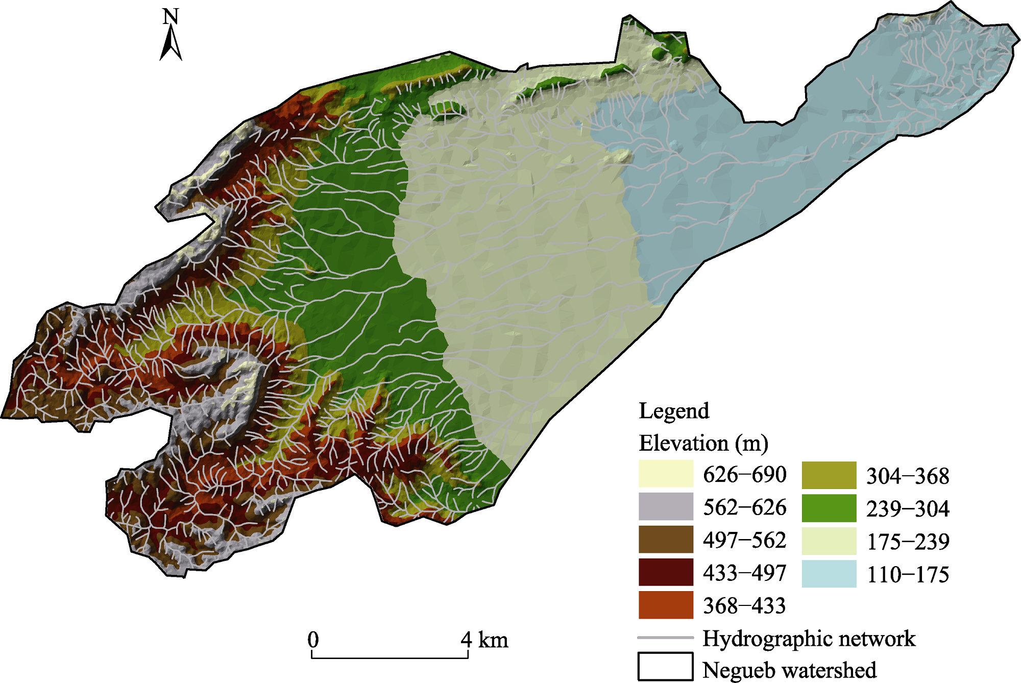
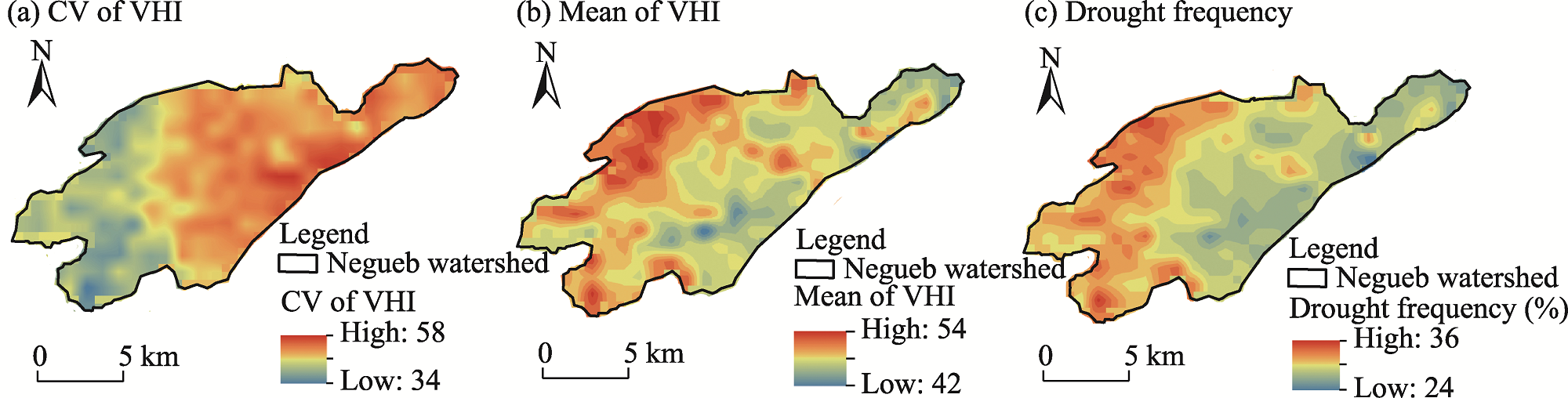
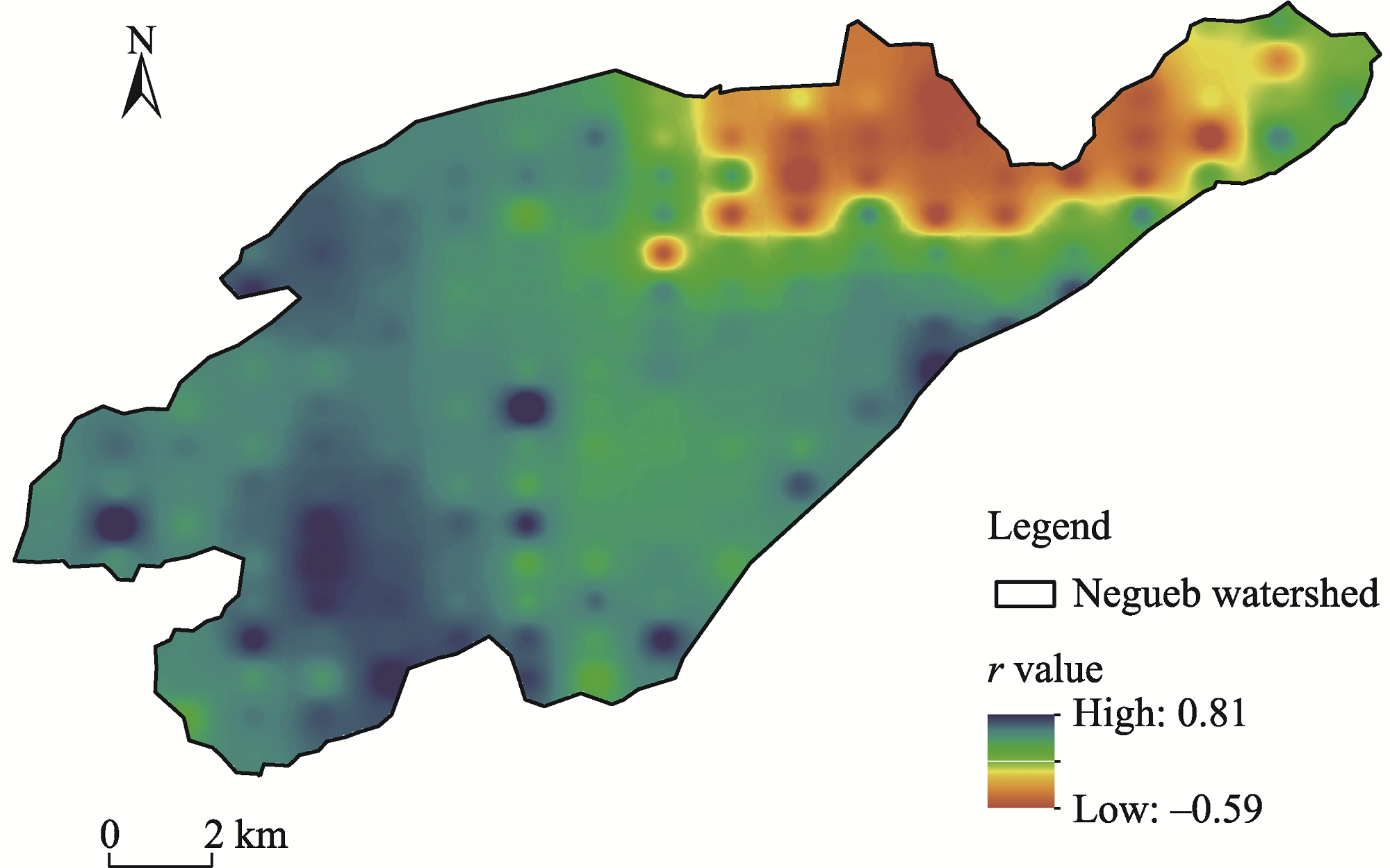
Abstract Droughts and soil erosion are among the most prominent climatic driven hazards in drylands, leading to detrimental environmental impacts, such as degraded lands, deteriorated ecosystem services and biodiversity, and increased greenhouse gas emissions. In response to the current lack of studies combining drought conditions and soil erosion processes, in this study, we developed a comprehensive Geographic Information System (GIS)-based approach to assess soil erosion and droughts, thereby revealing the relationship between soil erosion and droughts under an arid climate. The vegetation condition index (VCI) and temperature condition index (TCI) derived respectively from the enhanced vegetation index (EVI) MOD13A2 and land surface temperature (LST) MOD11A2 products were combined to generate the vegetation health index (VHI). The VHI has been conceived as an efficient tool to monitor droughts in the Negueb watershed, southeastern Tunisia. The revised universal soil loss equation (RUSLE) model was applied to quantitatively estimate soil erosion. The relationship between soil erosion and droughts was investigated through Pearson correlation. Results exhibited that the Negueb watershed experienced recurrent mild to extreme drought during 2000-2016. The average soil erosion rate was determined to be 1.8 t/(hm2·a). The mountainous western part of the watershed was the most vulnerable not only to soil erosion but also to droughts. The slope length and steepness factor was shown to be the most significant controlling parameter driving soil erosion. The relationship between droughts and soil erosion had a positive correlation (r=0.3); however, the correlation was highly varied spatially across the watershed. Drought was linked to soil erosion in the Negueb watershed. The current study provides insight for natural disaster risk assessment, land managers, and stake-holders to apply appropriate management measures to promote sustainable development goals in fragile environments.
|
|
Received: 05 December 2022
Published: 30 November 2023
|
Corresponding Authors:
* Wanchang Zhang (E-mail: zhangwc@radi.ac.cn)
|
|
|
| [1] |
Abdelhak M. 2022. Soil improvement in arid and semiarid regions for sustainable development. Natural Resources Conservation and Advances for Sustainability, doi: 10.1016/B978-0-12-822976-7.00026-0.
|
|
|
| [2] |
Ahn S, Doerr S H, Douglas P, et al. 2013. Effects of hydrophobicity on splash erosion of model soil particles by a single water drop impact. Earth Surface Processes and Landforms, 38(11): 1225-1233.
doi: 10.1002/esp.v38.11
|
|
|
| [3] |
Alamdarloo E H, Manesh M B, Khosravi H. 2018. Probability assessment of vegetation vulnerability to drought based on remote sensing data. Environmental Monitoring and Assessment, 190: 702, doi: 10.1007/s10661-018-7089-1.
pmid: 30406494
|
|
|
| [4] |
Amellah O, el Morabiti K. 2021. Assessment of soil erosion risk severity using GIS, remote sensing and RUSLE model in Oued Laou Basin (north Morocco). Soil Science Annual, 72(3): 142530, doi: 10.37501/soilsa/142530.
|
|
|
| [5] |
Arnoldus H M J. 1977. Predicting Soil Losses Due to Sheet and Rill Erosion. FAO Conservation Guide 1: Guidelines for Watershed Management. Rome: FAO.
|
|
|
| [6] |
Ballah A, Benaabidate L. 2021. Assessing the performance of various meteorological drought indices in capturing historic droughts in the south of Algeria. Arabian Journal of Geosciences, 14(13): 1289, doi: 10.1007/s12517-021-07556-8.
|
|
|
| [7] |
Baskan O. 2021. Analysis of spatial and temporal changes of RUSLE-K soil erodibility factor in semi-arid areas in two different periods by conditional simulation. Archives of Agronomy and Soil Science, doi: 10.1080/03650340.2021.1922673.
|
|
|
| [8] |
Bayer Altin T, Altin B N. 2021. Response of hydrological drought to meteorological drought in the eastern Mediterranean Basin of Turkey. Journal of Arid Land, 13(5): 470-486.
doi: 10.1007/s40333-021-0064-7
|
|
|
| [9] |
Bayissa Y, Moges S, Melesse A, et al. 2021. Multi-dimensional drought assessment in Abbay/Upper Blue Nile Basin: The importance of shared management and regional coordination efforts for mitigation. Remote Sensing, 13(9): 1835, doi: 10.3390/rs13091835.
|
|
|
| [10] |
Belaid H, Habaieb H. 2015. Soil aggregate stability in a Tunisian semi-arid environment with reference to fractal analysis. Journal of Soil Science and Environmental Management, 6(2): 16-23.
doi: 10.5897/JSSEM
|
|
|
| [11] |
Ben Rhouma A, Hermassi T, Habaieb H. 2018. Water erosion modeling in a Mediterranean semi-arid catchment using USLE/GIS (El Gouazine, Central Tunisia). Journal of New Sciences, 50: 3071-3081.
|
|
|
| [12] |
Bensekhria A, Bouhata R. 2022. Assessment and mapping soil water erosion using RUSLE approach and GIS tools: case of oued el-Hai watershed, Aurès West, Northeastern of Algeria. ISPRS International Journal of Geo-Information, 11(2): 84, doi: 10.3390/ijgi11020084.
|
|
|
| [13] |
Bento V A, Gouveia C M, DaCamara C C, et al. 2020. The roles of NDVI and land surface temperature when using the vegetation health index over dry regions. Global and Planetary Change, 190: 103198, doi: 10.1016/j.gloplacha.2020.103198.
|
|
|
| [14] |
Bombino G, Denisi P, Gómez J A, et al. 2019. Water infiltration and surface runoff in steep clayey soils of olive groves under different management practices. Water, 11(2): 240, doi: 10.3390/w11020240.
|
|
|
| [15] |
Bonaccorso B, Peres D J, Cancelliere A, et al. 2013. Large scale probabilistic drought characterization over Europe. Water Resources Management, 27(6): 1675-1692.
doi: 10.1007/s11269-012-0177-z
|
|
|
| [16] |
Borrelli P, Robinson D A, Fleischer L R, et al. 2017. An assessment of the global impact of 21st century land use change on soil erosion. Nature Communications, 8, doi: 10.1038/s41467-017-02142-7.
|
|
|
| [17] |
Brychta J, Podhrázská J, Šťastná M. 2022. Review of methods of spatio-temporal evaluation of rainfall erosivity and their correct application. CATENA, 217: 106454, doi: 10.1016/j.catena.2022.106454.
|
|
|
| [18] |
Chafai A, Brahim N, Shimi N S. 2020. Mapping of water erosion by GIS/RUSLE approach: watershed Ayda river—Tunisia study. Arabian Journal of Geosciences, 13(16): 1-14.
doi: 10.1007/s12517-019-5007-7
|
|
|
| [19] |
Cook B I, Anchukaitis K J, Touchan R, et al. 2016. Spatiotemporal drought variability in the Mediterranean over the last 900 years. Journal of Geophysical Research: Atmospheres, 121(5): 2060-2074.
doi: 10.1002/jgrd.v121.5
|
|
|
| [20] |
Cormary Y, Masson J. 1964. Study of water and soil conservation at the Rural Engineering Research Center of Tunisia: Application of Wischmeier's soil loss formula to a typical project. ORSTOM Notebooks - Pedology Series, 2(3): 3-26. (in French)
|
|
|
| [21] |
Dahal N M, Xiong D, Neupane N, et al. 2021. Spatiotemporal analysis of drought variability based on the standardized precipitation evapotranspiration index in the Koshi River Basin, Nepal. Journal of Arid Land, 13(5): 433-454.
doi: 10.1007/s40333-021-0065-6
|
|
|
| [22] |
da Silva E C, de Albuquerque M B, de Azevedo Neto A D, et al. 2013. Drought and its consequences to plants—From individual to ecosystem. Responses of Organisms to Water Stress, 18-47.
|
|
|
| [23] |
Diodato N, Bellocchi G. 2010. MedREM, a rainfall erosivity model for the Mediterranean region. Journal of Hydrology, 387(1-2): 119-127.
doi: 10.1016/j.jhydrol.2010.04.003
|
|
|
| [24] |
Du H, Dou S, Deng X, et al. 2016. Assessment of wind and water erosion risk in the watershed of the Ningxia-Inner Mongolia Reach of the Yellow River, China. Ecological Indicators, 67: 117-131.
doi: 10.1016/j.ecolind.2016.02.042
|
|
|
| [25] |
Duiker S, Flanagan D, Lal R. 2001. Erodibility and infiltration characteristics of five major soils of southwest Spain. CATENA, 45(2): 103-121.
doi: 10.1016/S0341-8162(01)00145-X
|
|
|
| [26] |
DVWK. 1990. Sediment Transport in Open Channels. Berlin: German Association for Water and Land Improvement.
|
|
|
| [27] |
Eekhout J P C, de Vente J. 2022. Global impact of climate change on soil erosion and potential for adaptation through soil conservation. Earth-Science Reviews, 226: 103921, doi: 10.1016/j.earscirev.2022.103921.
|
|
|
| [28] |
Elbouqdaoui K, Ezzine H, Badraoui M, et al. 2005. Evaluation by remote sensing and SIG of potential erosion risk in the Oued Srou Basin (Middle Atlas, Morocco). International Journal of Tropical Geology, Geography and Ecology, 29: 25-36.
|
|
|
| [29] |
Ellouze M, Azri C, Abida H. 2009. Spatial variability of monthly and annual rainfall data over Southern Tunisia. Atmospheric Research, 93(4): 832-839.
doi: 10.1016/j.atmosres.2009.04.005
|
|
|
| [30] |
Ezzine H, Bouziane A, Ouazar D. 2014. Seasonal comparisons of meteorological and agricultural drought indices in Morocco using open short time-series data. International Journal of Applied Earth Observation and Geoinformation, 26: 36-48.
doi: 10.1016/j.jag.2013.05.005
|
|
|
| [31] |
Fang G, Yuan T, Zhang Y, et al. 2019. Integrated study on soil erosion using RUSLE and GIS in Yangtze River Basin of Jiangsu Province (China). Arabian Journal of Geosciences, 12(5): 1-13.
doi: 10.1007/s12517-018-4128-8
|
|
|
| [32] |
FAO. 1977. Conservation Guide 1. Guidelines for Watershed Management. Rome: FAO, 147-179.
|
|
|
| [33] |
FAO. 2015. World Reference Base for Soil Resources 2014. International Soil Classification System for Naming Soils and Creating Legends for Soil Maps. [2022-11-23]. https://www.fao.org/3/i3794en/I3794en.pdf.
|
|
|
| [34] |
FAO. 2016. Food Outlook - Biannual Report on Global Food Markets. Rome: FAO, 100.
|
|
|
| [35] |
Feki H, Slimani M, Cudennec C. 2012. Incorporating elevation in rainfall interpolation in Tunisia using geostatistical methods. Hydrological Sciences Journal, 57(7): 1294-1314.
doi: 10.1080/02626667.2012.710334
|
|
|
| [36] |
Feng W, Lu H, Yao T, et al. 2020. Drought characteristics and its elevation dependence in the Qinghai-Tibet plateau during the last half-century. Scientific Reports, 10(1): 1-11.
doi: 10.1038/s41598-019-56847-4
|
|
|
| [37] |
Ferro V, Giordano G, Iovino M. 1991. Isoerosivity and erosion risk map for Sicily. Hydrological Sciences Journal, 36(6): 549-564.
doi: 10.1080/02626669109492543
|
|
|
| [38] |
Floret C, Pontanier R. 1982. Aridity in Pre-Saharan Tunisia: Climate, Soil, Vegetation and Development. Paris: ORSTOM. (in French)
|
|
|
| [39] |
Gamoun M. 2016. Rain use efficiency, primary production and rainfall relationships in desert rangelands of Tunisia. Land Degradation & Development, 27(3): 738-747.
doi: 10.1002/ldr.v27.3
|
|
|
| [40] |
Gargouri K, Laajimi A, Chebil A, et al. 2010. Drought occurrence and its impact on olive production and cereals in Tunisia. Séminaires Méditerranéens, (95): 41-47.
|
|
|
| [41] |
Genin D, Guillaume H, Ouessar M, et al. 2006. Between Desertification and Development: the Tunisian Jeffara. Tunis: IRD. (in French)
|
|
|
| [42] |
Ghoneim E, Dorofeeva A, Benedetti M, et al. 2017. Vegetation drought analysis in Tunisia: a geospatial investigation. Journal of Atmospheric & Earth Sciences, 1(2), doi: 10.24966/AES-8780/100002.
|
|
|
| [43] |
Gidey E, Dikinya O, Sebego R, et al. 2018. Analysis of the long-term agricultural drought onset, cessation, duration, frequency, severity and spatial extent using Vegetation Health Index (VHI) in Raya and its environs, Northern Ethiopia. Environmental Systems Research, 7(1): 13, doi: 10.1186/s40068-018-0115-z.
|
|
|
| [44] |
Guo B, Lu M, Fan Y, et al. 2023. A novel remote sensing monitoring index of salinization based on three-dimensional feature space model and its application in the Yellow River Delta of China. Geomatics, Natural Hazards and Risk, 14(1): 95-116.
doi: 10.1080/19475705.2022.2156820
|
|
|
| [45] |
Haied N, Foufou A, Chaab S, et al. 2017. Drought assessment and monitoring using meteorological indices in a semi-arid region. Energy Procedia, 119: 518-529.
doi: 10.1016/j.egypro.2017.07.064
|
|
|
| [46] |
Hazaymeh K, Hassan Q K. 2017. A remote sensing-based agricultural drought indicator and its implementation over a semi-arid region, Jordan. Journal of Arid Land, 9(3): 319-330.
doi: 10.1007/s40333-017-0014-6
|
|
|
| [47] |
He Q, Dai X A, Chen S. 2020. Assessing the effects of vegetation and precipitation on soil erosion in the Three-River Headwaters Region of the Qinghai-Tibet Plateau, China. Journal of Arid Land, 12(5): 865-886.
doi: 10.1007/s40333-020-0075-9
|
|
|
| [48] |
Heim R R. 2002. A review of twentieth-century drought indices used in the United States. Bulletin of the American Meteorological Society, 83(8): 1149-1166.
doi: 10.1175/1520-0477(2002)083<1149:AROTDI>2.3.CO;2
|
|
|
| [49] |
Hewelke E, Gozdowski D, Korc M, et al. 2022. Influence of soil moisture on hydrophobicity and water sorptivity of sandy soil no longer under agricultural use. CATENA, 208: 105780, doi: 10.1016/j.catena.2021.105780.
|
|
|
| [50] |
Imamoglu A, Dengiz O. 2017. Determination of soil erosion risk using RUSLE model and soil organic carbon loss in Alaca catchment (Central Black Sea region, Turkey). Rendiconti Lincei, 28: 11-23.
doi: 10.1007/s12210-016-0556-0
|
|
|
| [51] |
Jemai S, Kallel A, Agoubi B, et al. 2021. Soil erosion estimation in arid area by USLE model applying GIS and RS: Case of Oued El Hamma catchment, south-eastern Tunisia. Journal of the Indian Society of Remote Sensing, 49(6): 1293-1305.
doi: 10.1007/s12524-021-01320-x
|
|
|
| [52] |
Karnieli A, Bayasgalan M, Bayarjargal Y, et al. 2006. Comments on the use of the vegetation health index over Mongolia. International Journal of Remote Sensing, 27(10): 2017-2024.
doi: 10.1080/01431160500121727
|
|
|
| [53] |
Kefi M, Yoshino K, Setiawan Y. 2012. Assessment and mapping of soil erosion risk by water in Tunisia using time series MODIS data. Paddy and Water Environment, 10(1): 59-73.
doi: 10.1007/s10333-011-0265-3
|
|
|
| [54] |
Keyantash J, Dracup J A. 2002. The quantification of drought: An evaluation of drought indices. Bulletin of the American Meteorological Society, 83(8): 1167-1180.
doi: 10.1175/1520-0477(2002)083<1191:TQODAE>2.3.CO;2
|
|
|
| [55] |
Kogan F N. 1995. Application of vegetation index and brightness temperature for drought detection. Advances in Space Research, 15(11): 91-100.
|
|
|
| [56] |
Kogan F, Guo W, Strashnaia A, et al. 2016. Modelling and prediction of crop losses from NOAA polar-orbiting operational satellites. Geomatics, Natural Hazards and Risk, 7(3): 886-900.
doi: 10.1080/19475705.2015.1009178
|
|
|
| [57] |
König H J, Sghaier M, Schuler J, et al. 2012. Participatory impact assessment of soil and water conservation scenarios in Oum Zessar watershed, Tunisia. Environmental Management, 50(1): 153-165.
doi: 10.1007/s00267-012-9865-y
pmid: 22573361
|
|
|
| [58] |
Lazzari M, Gioia D, Piccarreta M, et al. 2015. Sediment yield and erosion rate estimation in the mountain catchments of the Camastra artificial reservoir (Southern Italy): A comparison between different empirical methods. CATENA, 127: 323-339.
doi: 10.1016/j.catena.2014.11.021
|
|
|
| [59] |
Le Houérou H N. 1996. Climate change, drought and desertification. Journal of Arid Environments, 34(2): 133-185.
doi: 10.1006/jare.1996.0099
|
|
|
| [60] |
Liu B Y, Nearing M A, Shi P J, et al. 2000. Slope length effects on soil loss for steep slopes. Soil Science Society of America Journal, 64(5): 1759-1763.
doi: 10.2136/sssaj2000.6451759x
|
|
|
| [61] |
Liu W, Kogan F. 1996. Monitoring regional drought using the vegetation condition index. International Journal of Remote Sensing, 17(14): 2761-2782.
doi: 10.1080/01431169608949106
|
|
|
| [62] |
Liu Y, Guo B, Lu M, et al. 2023. Quantitative distinction of the relative actions of climate change and human activities on vegetation evolution in the Yellow River Basin of China during 1981-2019. Journal of Arid Land, 15(1): 91-108.
doi: 10.1007/s40333-022-0079-8
|
|
|
| [63] |
Lloyd-Hughes B. 2013. The impracticality of a universal drought definition. Theoretical and Applied Climatology, 117, doi: 10.1007/s00704-013-1025-7.
|
|
|
| [64] |
Lu S, Liu B, Hu Y, et al. 2020. Soil erosion topographic factor (LS): Accuracy calculated from different data sources. CATENA, 187: 104334, doi: 10.1016/j.catena.2019.104334.
|
|
|
| [65] |
Lucatello S, Huber-Sannwald E. 2020. Sustainable Development Goals and Drylands: Addressing the Interconnection. [2022-11-20]. https://link.springer.com/chapter/10.1007/978-3-030-22464-6_2.
|
|
|
| [66] |
Magesh N, Chandrasekar N. 2016. Assessment of soil erosion and sediment yield in the Tamiraparani sub-basin, South India, using an automated RUSLE-SY model. Environmental Earth Sciences, 75(16): 1-17.
doi: 10.1007/s12665-015-4873-x
|
|
|
| [67] |
Markose V J, Jayappa K. 2016. Soil loss estimation and prioritization of sub-watersheds of Kali River basin, Karnataka, India, using RUSLE and GIS. Environmental Monitoring Assessment, 188(4): 1-16.
doi: 10.1007/s10661-015-4999-z
|
|
|
| [68] |
Marumbwa F M, Cho M A, Chirwa P W. 2020. An assessment of remote sensing-based drought index over different land cover types in southern Africa. International Journal of Remote Sensing, 41(19): 7368-7382.
doi: 10.1080/01431161.2020.1757783
|
|
|
| [69] |
Masroor M, Sajjad H, Rehman S, et al. 2022. Analysing the relationship between drought and soil erosion using vegetation health index and RUSLE models in Godavari middle sub-basin, India. Geoscience Frontiers, 13(2): 101312, doi: 10.1016/j.gsf.2021.101312.
|
|
|
| [70] |
Mbiriri M, Mukwada G, Manatsa D. 2018. Influence of altitude on the spatiotemporal variations of meteorological droughts in mountain regions of the free state province, South Africa (1960-2013). Advances in Meteorology, 2018: 5206151, doi: 10.1155/2018/5206151.
|
|
|
| [71] |
MEHAT. 2012. Atlas of Medenine Governorate. Tunis: Ministry of Housing Equipment and Territorial Planning of Tunisia, 104. (in French)
|
|
|
| [72] |
Middleton N, Kang U. 2017. Sand and dust storms: Impact mitigation. Sustainability, 9(6): 1053, doi: 10.3390/su9061053.
|
|
|
| [73] |
Mtimet A. 2001. Soils of Tunisia. Options Méditerranéennes, 34: 243-268.
|
|
|
| [74] |
Napoli M, Cecchi S, Orlandini S, et al. 2016. Simulation of field-measured soil loss in Mediterranean hilly areas (Chianti, Italy) with RUSLE. CATENA, 145: 246-256.
doi: 10.1016/j.catena.2016.06.018
|
|
|
| [75] |
Omuto C, Vargas R. 2009. Combining pedometrics, remote sensing and field observations for assessing soil loss in challenging drylands: a case study of northwestern Somalia. Land Degradation & Development, 20(1): 101-115.
doi: 10.1002/ldr.v20:1
|
|
|
| [76] |
Pachauri R K, Allen M R, Barros V R, et al. 2014. Climate Change 2014:Synthesis Report. Contribution of Working Groups I, II and III to the Fifth Assessment Report of the Intergovernmental Panel on Climate Change, IPCC. [2022-11-22]. https://www.ipcc.ch/site/assets/uploads/2018/05/SYR_AR5_FINAL_full_wcover.pdf.
|
|
|
| [77] |
Parviz L. 2016. Determination of effective indices in the drought monitoring through analysis of satellite images. Agriculture and Forestry, 62(1): 305, doi: 10.17707/AgricultForest.62.1.34.
|
|
|
| [78] |
Patil R J. 2018. Spatial techniques for soil erosion estimation. In: Patil R J. Spatial Techniques for Soil Erosion Estimation: Remote Sensing and GIS Approach. Switzerland: Springer.
|
|
|
| [79] |
Pei F, Wu C, Liu X, et al. 2018. Monitoring the vegetation activity in China using vegetation health indices. Agricultural and Forest Meteorology, 248: 215-227.
doi: 10.1016/j.agrformet.2017.10.001
|
|
|
| [80] |
Pepin N, Bradley R S, Diaz H F, et al. 2015. Elevation-dependent warming in mountain regions of the world. Nature Climate Change, 5(5): 424-430.
doi: 10.1038/nclimate2563
|
|
|
| [81] |
Pepin Y, Hammouda N. 2012. Variability of rainfall intensity in the Tangier region over a period of 30 years (1980-2010). Revue marocaine des sciences agronomiques et vétérinaires, 1(1): 23-27. (in French)
|
|
|
| [82] |
Peri P L, Lasagno R G, Chartier M, et al. 2021. Soil erosion rates and nutrient loss in rangelands of southern Patagonia. In: The Encyclopedia of Conservation—Reference Module in Earth Systems and Environmental Sciences. Netherlands: Elsevier.
|
|
|
| [83] |
Phinzi K, Ngetar N S. 2019. The assessment of water-borne erosion at catchment level using GIS-based RUSLE and remote sensing: A review. International Soil and Water Conservation Research, 7(1): 27-46.
doi: 10.1016/j.iswcr.2018.12.002
|
|
|
| [84] |
Prasannakumar V, Vijith H, Abinod S, et al. 2012. Estimation of soil erosion risk within a small mountainous sub-watershed in Kerala, India, using Revised Universal Soil Loss Equation (RUSLE) and geo-information technology. Geoscience Frontiers, 3(2): 209-215.
doi: 10.1016/j.gsf.2011.11.003
|
|
|
| [85] |
Qiu J, Shen Z, Leng G, et al. 2021. Synergistic effect of drought and rainfall events of different patterns on watershed systems. Scientific Reports, 11(1): 1-18.
doi: 10.1038/s41598-020-79139-8
|
|
|
| [86] |
Rahmati O, Tahmasebipour N, Haghizadeh A, et al. 2017. Evaluating the influence of geo-environmental factors on gully erosion in a semi-arid region of Iran: An integrated framework. Science of the Total Environment, 579: 913-927.
doi: 10.1016/j.scitotenv.2016.10.176
|
|
|
| [87] |
Rangwala I, Miller J R. 2012. Climate change in mountains: a review of elevation-dependent warming and its possible causes. Climatic Change, 114(3): 527-547.
doi: 10.1007/s10584-012-0419-3
|
|
|
| [88] |
Reichhuber A, Gerber N, Mirzabaev A, et al. 2019. The land-drought nexus enhancing the role of land-based interventions in drought mitigation and risk management. [2022-11-22]. https://www.unccd.int/resources/reports/land-drought-nexus-enhancing-role-land-based-interventions-drought-mitigation-and.
|
|
|
| [89] |
Renard K G, Freimund J R. 1994. Using monthly precipitation data to estimate the R-factor in the revised USLE. Journal of Hydrology, 157(1-4): 287-306.
doi: 10.1016/0022-1694(94)90110-4
|
|
|
| [90] |
Renard K G, Foster G R, Weesies G A, et al. 1997. Predicting Soil Erosion by Water - A Guide to Conservation Planning with the Revised Universal Soil Loss Equation (RUSLE). Washington DC: United States Government Printing.
|
|
|
| [91] |
Renard K G, Laflen J, Foster G, et al. 2017. The revised universal soil loss equation. Soil Erosion Research Methods, 105-126.
|
|
|
| [92] |
Rhee J, Jm J, Carbone G J. 2010. Monitoring agricultural drought for arid and humid regions using multi-sensor remote sensing data. Remote Sensing of Environment, 114(12): 2875-2887.
doi: 10.1016/j.rse.2010.07.005
|
|
|
| [93] |
Rojas O, Vrieling A, Rembold F. 2011. Assessing drought probability for agricultural areas in Africa with coarse resolution remote sensing imagery. Remote Sensing of Environment, 115(2): 343-352.
doi: 10.1016/j.rse.2010.09.006
|
|
|
| [94] |
Roose E. 1977. Use of the universal soil loss equation to predict erosion in West Africa. Soil Erosion: Prediction and Control (21): 60-74.
|
|
|
| [95] |
Santra A, Mitra S S. 2020. Space-time drought dynamics and soil erosion in Puruliya district of West Bengal, India: A conceptual design. Journal of the Indian Society of Remote Sensing, 48: 1191-1205.
doi: 10.1007/s12524-020-01147-y
|
|
|
| [96] |
Schiettecatte W, Ouessar M, Gabriels D, et al. 2005. Impact of water harvesting techniques on soil and water conservation: A case study on a micro catchment in southeastern Tunisia. Journal of Arid Environments, 61(2): 297-313.
doi: 10.1016/j.jaridenv.2004.09.022
|
|
|
| [97] |
Seiler R, Kogan F, Sullivan J. 1998. AVHRR-based vegetation and temperature condition indices for drought detection in Argentina. Advances in Space Research, 21(3): 481-484.
doi: 10.1016/S0273-1177(97)00884-3
|
|
|
| [98] |
Sghaier M, Arbi A M, Tonneau J-P, et al. 2012. Land Degradation in the Arid Jeffara Region, Tunisia. Land Use Policies for Sustainable Development:Exploring Integrated Assessment Approaches. Cheltenham: Edward Elgar Publishing.
|
|
|
| [99] |
Shen R, Huang A, Li B, et al. 2019. Construction of a drought monitoring model using deep learning based on multi-source remote sensing data. International Journal of Applied Earth Observation and Geoinformation, 79: 48-57.
doi: 10.1016/j.jag.2019.03.006
|
|
|
| [100] |
Singh R P, Roy S, Kogan F. 2003. Vegetation and temperature condition indices from NOAA AVHRR data for drought monitoring over India. International Journal of Remote Sensing, 24(22): 4393-4402.
doi: 10.1080/0143116031000084323
|
|
|
| [101] |
Taamallah H. 2003. Soil Map of Jeffara. Tunis: IRA/IRD. (in French)
|
|
|
| [102] |
Tamene L, Le Q B. 2015. Estimating soil erosion in sub-Saharan Africa based on landscape similarity mapping and using the revised universal soil loss equation (RUSLE). Nutrient Cycling in Agroecosystems, 102(1): 17-31.
doi: 10.1007/s10705-015-9674-9
|
|
|
| [103] |
Terwayet Bayouli O, Zhang W, Terwayet Bayouli H. 2023. Assessment of drought characteristics and its impacts on net primary productivity (NPP) in southeastern Tunisia. Arabian Journal of Geosciences, 16(1): 26, doi: 10.1007/s12517-022-11091-5.
|
|
|
| [104] |
Toubal A K, Achite M, Ouillon S, et al. 2018. Soil erodibility mapping using the RUSLE model to prioritize erosion control in the Wadi Sahouat basin, North-West of Algeria. Environmental Monitoring Assessment, 190(4): 1-22.
doi: 10.1007/s10661-017-6336-1
|
|
|
| [105] |
Trnka M, Semeradova D, Novotný I, et al. 2016. Assessing the combined hazards of drought, soil erosion and local flooding on agricultural land: A Czech case study. Climate Research, 70, doi: 10.3354/cr01421.
|
|
|
| [106] |
Verner D, Treguer D, Redwood J, et al. 2018. Climate Variability, Drought, and Drought Management in Tunisia's Agricultural Sector. [2022-11-21]. https://documents1.worldbank.org/curated/en/318211538415630621/pdf/130406-WP-P159856-Tunisia-WEB2.pdf.
|
|
|
| [107] |
Wischmeier W H, Smith D D. 1978. Predicting Rainfall Erosion Losses:A Guide to Conservation Planning. Washington DC: Department of Agriculture, Science and Education Administration,
|
|
|
| [108] |
Wu G, Chen J, Shi X, et al. 2022. Impacts of global climate warming on meteorological and hydrological droughts and their propagations. Earth's Future, 10(3), doi: e2021EF002542.
|
|
|
| [109] |
Yang D, Kanae S, Oki T, et al. 2003. Global potential soil erosion with reference to land use and climate changes. Hydrological Processes, 17(14): 2913-2928.
doi: 10.1002/hyp.v17:14
|
|
|
| [110] |
Yu Y, Shen Y, Wang J, et al. 2021. Simulation and mapping of drought and soil erosion in Central Yunnan Province, China. Advances in Space Research, 68(11): 4556-4572.
doi: 10.1016/j.asr.2021.08.028
|
|
|
| [111] |
Zargar A, Sadiq R, Naser B. 2011. A review of drought indices. Environmental Reviews, 19: 333-349.
doi: 10.1139/a11-013
|
|
|
| [112] |
Zhao Y, Liu L, Kang S, et al. 2021. Quantitative analysis of factors influencing spatial distribution of soil erosion based on geo-detector model under diverse geomorphological types. Land, 10(6): 604, doi: 10.3390/land10060604.
|
|
|
| [113] |
Zhu P, Jia X, Zhao C, et al. 2022. Long-term soil moisture evolution and its driving factors across China's agroecosystems. Agricultural Water Management, 269: 107735, doi: 10.1016/j.agwat.2022.107735.
|
|
|
|
Viewed |
|
|
|
Full text
|
|
|
|
|
Abstract
|
|
|
|
|
Cited |
|
|
|
|
| |
Shared |
|
|
|
|
| |
Discussed |
|
|
|
|