| Research article |
|


|
|
|
| Two-dimensional hydrodynamic robust numerical model of soil erosion based on slopes and river basins |
KANG Yongde1, HUANG Miansong2,*( ), HOU Jingming1,*(), TONG Yu1, PAN Zhanpeng1 ), HOU Jingming1,*(), TONG Yu1, PAN Zhanpeng1 |
1State Key Laboratory of Eco-hydraulics in Northwest Arid Region of China, School of Water Resources and Hydroelectric Engineering, Xi'an University of Technology, Xi'an 710048, China
2Beijing Capital Eco-Environment Protection Group Co. Ltd., Beijing 100028, China |
|
|
|
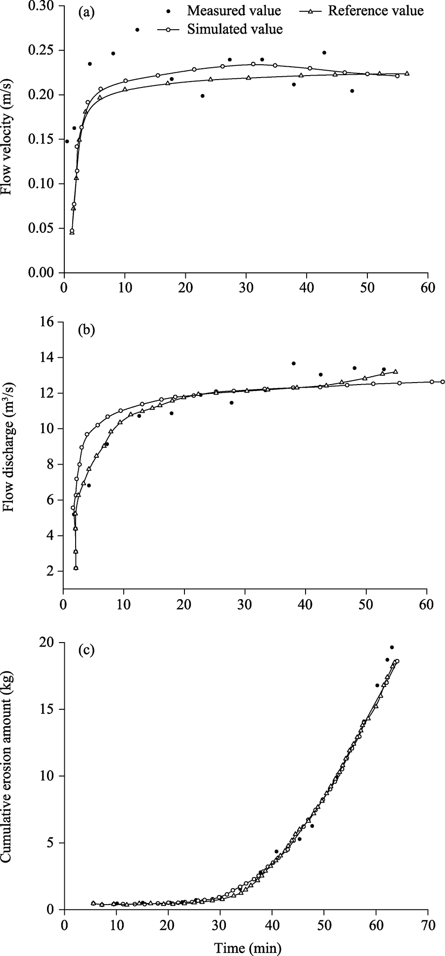
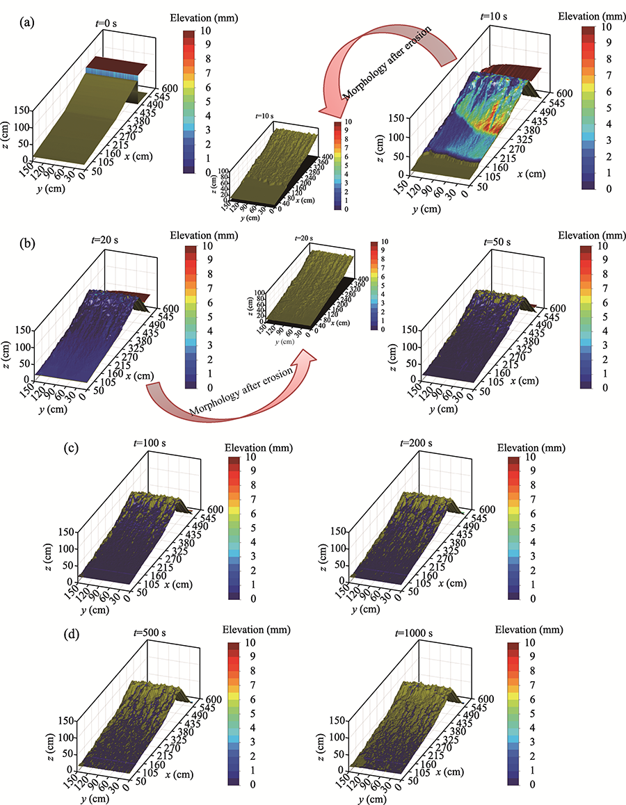
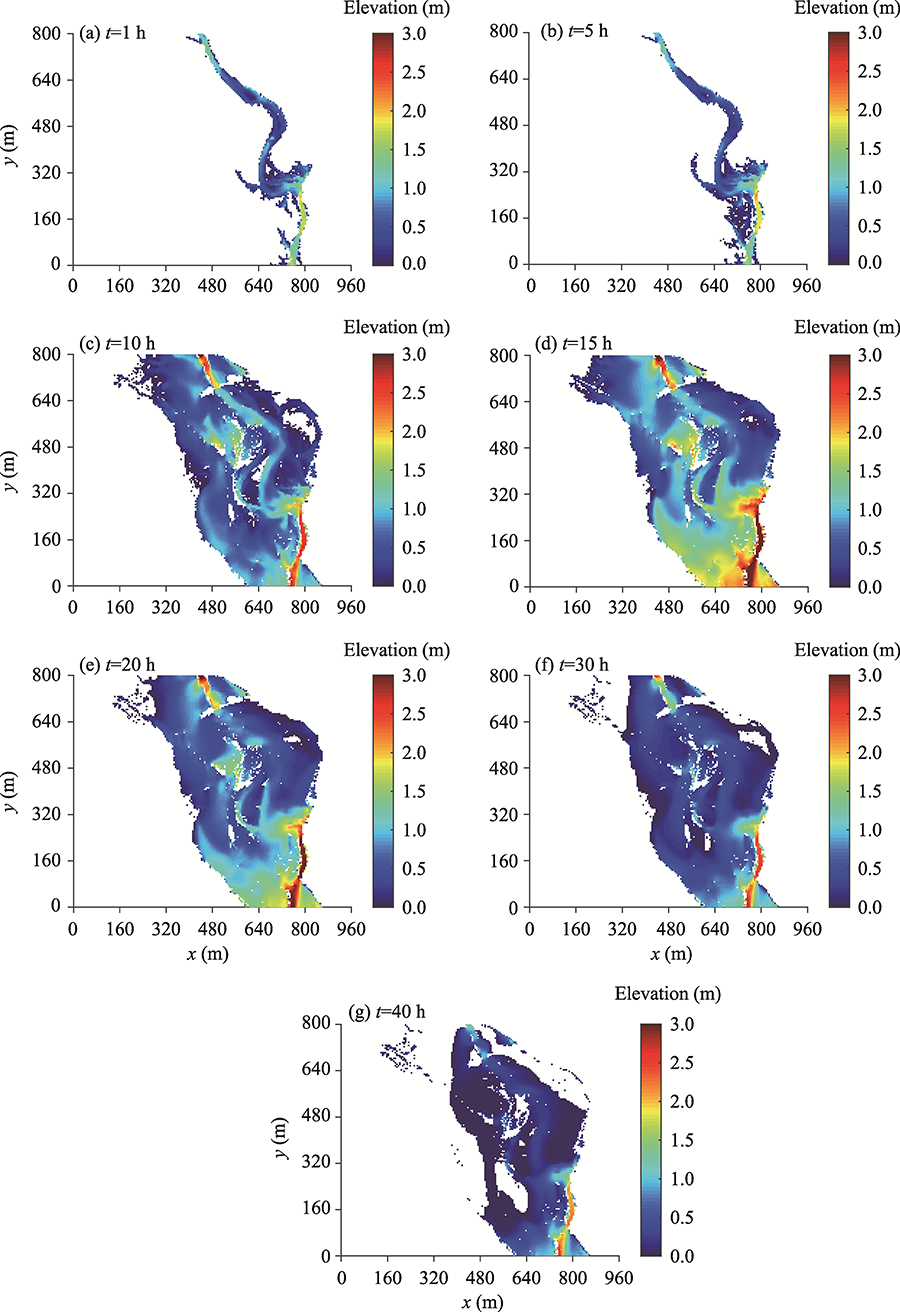
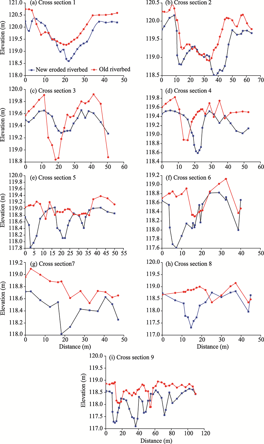
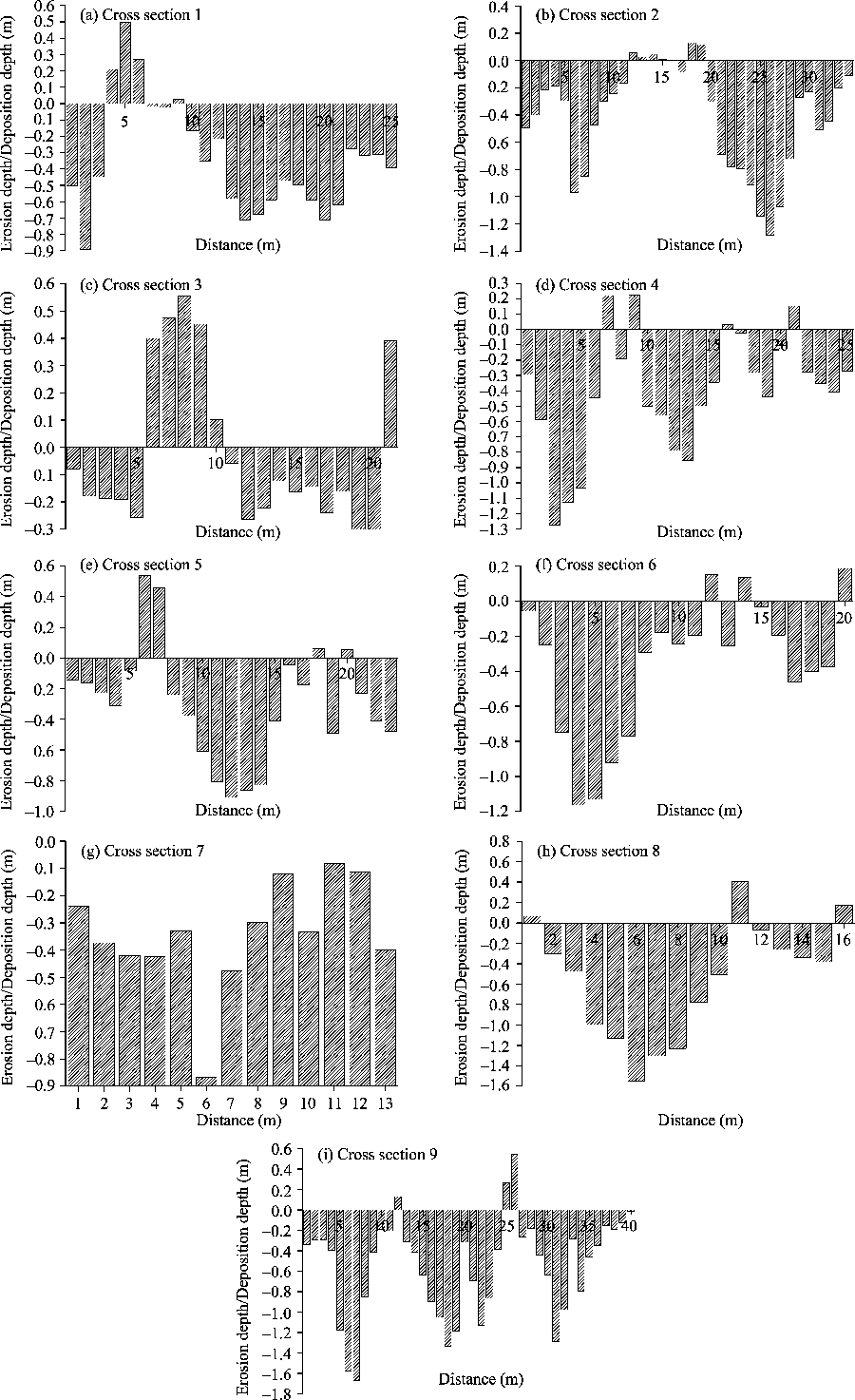
Abstract Erosion is an important issue in soil science and is related to many environmental problems, such as soil erosion and sediment transport. Establishing a simulation model suitable for soil erosion prediction is of great significance not only to accurately predict the process of soil separation by runoff, but also improve the physical model of soil erosion. In this study, we develop a graphic processing unit (GPU)-based numerical model that combines two-dimensional (2D) hydrodynamic and Green-Ampt (G-A) infiltration modelling to simulate soil erosion. A Godunov-type scheme on a uniform and structured square grid is then generated to solve the relevant shallow water equations (SWEs). The highlight of this study is the use of GPU-based acceleration technology to enable numerical models to simulate slope and watershed erosion in an efficient and high-resolution manner. The results show that the hydrodynamic model performs well in simulating soil erosion process. Soil erosion is studied by conducting calculation verification at the slope and basin scales. The first case involves simulating soil erosion process of a slope surface under indoor artificial rainfall conditions from 0 to 1000 s, and there is a good agreement between the simulated values and the measured values for the runoff velocity. The second case is a river basin experiment (Coquet River Basin) that involves watershed erosion. Simulations of the erosion depth change and erosion cumulative amount of the basin during a period of 1-40 h show an elevation difference of erosion at 0.5-3.0 m, especially during the period of 20-30 h. Nine cross sections in the basin are selected for simulation and the results reveal that the depth of erosion change value ranges from -0.86 to -2.79 m and the depth of deposition change value varies from 0.38 to 1.02 m. The findings indicate that the developed GPU-based hydrogeomorphological model can reproduce soil erosion processes. These results are valuable for rainfall runoff and soil erosion predictions on rilled hillslopes and river basins.
|
|
Received: 29 April 2021
Published: 10 October 2021
|
|
Corresponding Authors:
*HUANG Miansong (E-mail: hms@capitalwater.cn);HOU Jingming (E-mail: jingming.hou@xaut.edu.cn)
|
|
|
| [1] |
Abderrezzak K E, Die Moran A, Mosselman E, et al. 2013. A physical, movable-bed model for non-uniform sediment transport, fluvial erosion and bank failure in rivers. Journal of Hydro-environment Research, 8(2):95-114.
|
|
|
| [2] |
Aksoy H, Gedikli A, Unal N E, et al. 2016. Rainfall runoff model considering microtopography simulated in a laboratory erosion flume. Water Resources Management, 30(15):5609-5624.
|
|
|
| [3] |
An J, Zhang Y Q, Wang Y Y. 2020. Rainstorm pattern effects on the size distribution of soil aggregate in eroded sediment within contour ridge systems. Journal of Soils and Sediments, 20(4):2192-2206.
|
|
|
| [4] |
An Y, Liu Q Q. 2009. Two-dimensional hillslope scale soil erosion model. Journal of Hydrologic Engineering, 14(7):690-697.
|
|
|
| [5] |
Appels W M, Bogaart P W, van der Zee S E, 2011. Influence of spatial variations of microtopography and infiltration on surface runoff and field scale hydrological connectivity. Advances in Water Resources, 34(2):303-313.
|
|
|
| [6] |
Batista P V G, Davies J, Silva M LN, et al. 2019. On the evaluation of soil erosion models: Are we doing enough? Earth-Science Reviews, 197:102898, doi: 10.1016/j.earscirev.2019.102898.
|
|
|
| [7] |
Beven K J. 2012. Rainfall-Runoff Modelling: The Primer (2nd ed.). Chichester: Wiley-Blackwell, 3-15.
|
|
|
| [8] |
Bingner R L, Wells R R, Momm H G, et al. 2016. Ephemeral gully channel width and erosion simulation technology. Natural Hazards, 80(3):1949-1966.
|
|
|
| [9] |
Borrelli P, Robinson D A, Fleischer L R, et al. 2017. An assessment of the global impact of the 21st century land use change on soil erosion. Nature Communications, 8:1-13.
|
|
|
| [10] |
Bryndal T, Franczak P, Kroczak R, et al. 2017. The impact of extreme rainfall and flash floods on the flood risk management process and geomorphological changes in small Carpathian catchments: a case study of the Kasiniczanka river (Outer Carpathians, Poland). Natural Hazards, 88(1):95-120.
|
|
|
| [11] |
Cerdà A, Borja M E L, Úbeda X, et al. 2017. Pinus halepensis M. versus Quercus ilex subsp Rotundifolia L. runoff and soil erosion at pedon scale under natural rainfall in Eastern Spain three decades after a forest fire. Forest Ecology and Management, 400:447-456.
|
|
|
| [12] |
Chaplot V, Brown J, Dlamini P, et al. 2011. Rainfall simulation to identify the storm-scale mechanisms of gully bank retreat. Agricultural Water Management, 98(11):1704-1710.
|
|
|
| [13] |
Chen A Q, Zhang D, Peng H, et al. 2013. Experimental study on the development of collapse of overhanging layers of gully in Yuanmou Valley, China. CATENA, 109:177-185.
|
|
|
| [14] |
Chen H, Zhang X P, Abla M, et al. 2018. Effects of vegetation and rainfall types on surface runoff and soil erosion on steep slopes on the Loess Plateau, China. CATENA, 170:141-149.
|
|
|
| [15] |
Chen L, Sela S, Svoray T, et al. 2013. The role of soil-surface sealing, microtopography and vegetation patches in rainfall-runoff processes in semiarid areas. Water Resources Research, 49(9):5585-5599.
|
|
|
| [16] |
Chu S T. 1978. Infiltration during an unsteady rain. Water Resources Research, 14(3):461-466.
|
|
|
| [17] |
Danks M. 1998. Contemporary and historic river channel change at Swinhope bum, Weardale: a study of river response to flood events in an upland, gravel-bed stream. MSc Thesis. Durham: Durham University.
|
|
|
| [18] |
de Lima J L M P, Santos L, Mujtaba B, et al. 2019. Laboratory assessment of the influence of rice straw mulch size on soil loss. Advances in Geosciences, 48:11-18.
|
|
|
| [19] |
Di Stefano C, Ferro V, Palmeri V, et al. 2017. Flow resistance equation for rills. Hydrological Processes, 31(15):2793-2801.
|
|
|
| [20] |
Di Stefano C, Ferro V, Palmeri V, et al. 2018. Testing slope effect on flow resistance equation for mobile bed rills. Hydrological Processes, 32(5):664-671.
|
|
|
| [21] |
dos Santos J C N, de Andrade E M, Medeiros P H A, et al. 2017. Effect of rainfall characteristics on runoff and water erosion for different land uses in a tropical semiarid region. Water Resources Management, 31(1):173-185.
|
|
|
| [22] |
Fuller I C, Large A R G, Milan D J. 2003. Quantifying channel development and sediment transfer following chute cutoff in a wandering gravel-bed river. Geomorphology, 54(3-4):307-323.
|
|
|
| [23] |
González-Hidalgo J C, de Luis M, Batalla R J. 2009. Effects of the largest daily events on total soil erosion by rainwater. An analysis of the USLE database. Earth Surface Processes and Landforms, 34(15):2070-2077.
|
|
|
| [24] |
Gordon L M, Bennett S J, Wells R R. 2012. Response of a soil-mantled experimental landscape to exogenic forcing. Water Resources Research, 48:W10514, doi: 10.1029/2012WR012283.
|
|
|
| [25] |
Gottardi G, Venutelli M. 1993. A control-volume finite-element model for two-dimensional overland flow. Advances in Water Resources, 16(5):277-284.
|
|
|
| [26] |
Govindaraju R S, Kavvas M L, Tayfur G. 1992. A simplified model for two-dimensional overland flows. Advances in Water Resources, 15(2):133-141.
|
|
|
| [27] |
Green W H, Ampt G A. 1911. Studies on soil physics I. The flow of air and water through soils. Journal of Agricultural Science, 4:1-24.
|
|
|
| [28] |
Greimann B, Lai Y, Huang J C. 2008. Two-dimensional total sediment load model equations. Journal of Hydraulic Engineering, 134(8):1142-1146.
|
|
|
| [29] |
Guan M, Wright N G, Sleigh P A. 2014. 2D process based morphodynamical model for flooding by non-cohesive dyke breach. Journal of Hydraulic Engineering, 140(7):44-51.
|
|
|
| [30] |
Ham D G. 2005. Morphodynamics and sediment transport in a wandering gravel-bed channel: Fraser River, British Columbia. PhD Dissertation. British Columbia: University of British Columbia.
|
|
|
| [31] |
Hickin E J. 1984. Vegetation and river channel dynamics. The Canadian Geographer Le Géographe Canadien, 28(2):111-126.
|
|
|
| [32] |
Horton R E. 1933. The role of infiltration in the hydrological cycle. Transactions, American, Geophysical Union, 14(1):446-460.
|
|
|
| [33] |
Hou J M, Liang Q H, Simons F, et al. 2013a. A 2D well balanced shallow flow model for unstructured grids with novel slope source term treatment. Advances in Water Resources, 52:107-131.
|
|
|
| [34] |
Hou J M, Liang Q H, Simons F, et al. 2013b. A stable 2D unstructured shallow flow model for simulations of wetting and drying over rough terrains. Computers & Fluids, 82(17):132-147.
|
|
|
| [35] |
Hou J M, Liang Q H, Zhang H B, et al. 2015. An efficient unstructured MUSCL scheme for solving the 2D shallow water equations. Environmental Modelling & Software, 66:131-152.
|
|
|
| [36] |
Hou J M, Kang Y D, Hu C H, et al. 2020. A GPU-based numerical model coupling hydrodynamical and morphological processes. International Journal of Sediment Research, 35(4):386-394.
|
|
|
| [37] |
Howes D A, Abrahams A D, Pitman E B. 2006. One- and two-dimensional modelling of overland flow in semiarid shrubland, Jornada basin, New Mexico. Hydrological Processes, 20:1027-1046.
|
|
|
| [38] |
Hu P, Cao Z X. 2009. Fully coupled mathematical modeling of turbidity currents over erodible bed. Advances in Water Resources. 32(1):1-15.
|
|
|
| [39] |
Jiang D S. 1997. Soil and Water Loss in Loess Plateau and the Regulation Mode. Beijing: China Water & Power Press, 105-110. (in Chinese)
|
|
|
| [40] |
Liang Q, Marche F. 2009. Numerical resolution of well-balanced shallow water equations with complex source terms. Advances in Water Resources, 32(6):873-884.
|
|
|
| [41] |
Liu Q, Xiang H, Singh V P. 2006. A simulation model for unified interrill erosion and rill erosion on hillslopes. Hydrological Processes, 20:469-486.
|
|
|
| [42] |
Martinez-Casasnovas J A, Ramos M C, Poesen J. 2004. Assessment of sidewall erosion in large gullies using multi-temperal DEMs and logistic regression analysis. Geomorphology, 58(1-4):305-321.
|
|
|
| [43] |
Morgan R P C, Quinton J N, Smith R E, et al. 1998. The European Soil Erosion Model (EUROSEM): a dynamic approach for predicting sediment transport from fields and small catchments. Earth Surface Processes and Landforms, 23(6):527-544.
|
|
|
| [44] |
Newson M. 1980. The geomorphological effectiveness of floods—a contribution stimulated by two recent events in mid-wales. Earth Surface Processes and Landforms, 5(1):1-16.
|
|
|
| [45] |
Nord G, Esteves M. 2005. PSEM-2D: A physically based model of erosion processes at the plot scale. Water Resources Research, 41:1-14.
|
|
|
| [46] |
Panagos P, Katsoyiannis A. 2019. Soil erosion modelling: The new challenges as the result of policy developments in Europe. Environmental Research, 172:470-474.
|
|
|
| [47] |
Qin C, Zheng F L, Xu X M, et al. 2018a. A laboratory study on rill network development and morphological characteristics on loessial hillslope. Journal of Soils and Sediments, 18(4):1679-1690.
|
|
|
| [48] |
Qin C, Zheng F L, Zhang X C, et al. 2018b. A simulation of rill bed incision processes in upland concentrated flows. CATENA, 165:310-319.
|
|
|
| [49] |
Renard K G, Foster R, Weesies G, et al. 1997. Predicting soil erosion by water: A guide to conservation planning with the revised universal soil loss equation (RUSLE). USDA Agriculture Handbook 703. Washington, D.C.: United States Department of Agriculture, 1-404.
|
|
|
| [50] |
Shen H O, Zheng F L, Wen L L, et al. 2016. Impacts of rainfall intensity and slope gradient on rill erosion processes at loessial hillslope. Soil and Tillage Research, 155:429-436.
|
|
|
| [51] |
Smith J D, Mclean S R. 1977. Spatially averaged flow over a wavy surface. Journal of Geophysical Research, 82(12):1735-1746.
|
|
|
| [52] |
Smith R E, Goodrich D C, Woolhiser D A, et al. 1995. KINEROS: A Kinematic Runoff and Erosion Model. [2021-04-03]. https://www.tucson.ars.ag.gov/kineros/.
|
|
|
| [53] |
Stroosnijder L. 2005. Measurement of erosion: Is it possible? CATENA, 64(2-3):162-173.
|
|
|
| [54] |
Sweeney K E, Roering J J, Ellis C. 2015. Experimental evidence for hillslope control of landscape scale. Science, 349(6243):51-53.
|
|
|
| [55] |
Taye G, Poesen J, Van Wesemael B, et al. 2013. Effects of land use, slope gradient, and soil and water conservation structures on runoff and soil loss in semi-arid northern Ethiopia. Physical Geography, 34(3):236-259.
|
|
|
| [56] |
Tayfur G. 2007. Modelling sediment transport from bare rilled hillslopes by areally averaged transport equations. CATENA, 70(1):25-38.
|
|
|
| [57] |
Tian P, Xu X Y, Pan C Z, et al. 2017. Impacts of rainfall and inflow on rill formation and erosion processes on steep hillslopes. Journal of Hydrology, 548:24-39.
|
|
|
| [58] |
Wang T, Li P, Hou J M, et al. 2018. Response of the meltwater erosion to runoff energy consumption on loessal slopes. Water, 10(11):1522, doi: 10.3390/w10111522.
|
|
|
| [59] |
Wang W H, Jiao J Y. 1996. Rainfall and Erosion Sediment Yield in Loess Plateau and Sediment Transportation in the Yellow River Basin. Beijing: Science Press, 142-144. (in Chinese)
|
|
|
| [60] |
Wang Z J, Jiao J Y, Rayburg S, et al. 2016. Soil erosion resistance of ''Grain for Green'' vegetation types under extreme rainfall conditions on the Loess Plateau. China. CATENA, 141:109-116.
|
|
|
| [61] |
Wells R R, Momm H G, Rigby J R, et al. 2013. An empirical investigation of gully widening rates in upland concentrated flows. CATENA, 101:114-121.
|
|
|
| [62] |
Wirtz S, Seeger M, Ries J B. 2010. The rill experiment as a method to approach a quantification of rill erosion process activity. Zeitschrift Fur Geomorphologie, 54(1):47-64.
|
|
|
| [63] |
Wischmeier W H, Smith D D. 1978. Predicting rainfall erosion losses: A guide to conservation planning. The USDA Agricultural Handbook No. 537. Washington, D.C.: United States Department of Agriculture.
|
|
|
| [64] |
Woodward D E. 1999. Method to predict cropland ephemeral gully erosion. CATENA, 37(3-4):393-399.
|
|
|
| [65] |
Wu S B, Yu M H, Chen L. 2017. Nonmonotonic and spatial-temporal dynamic slope effects on soil erosion during rainfall-runoff processes. Water Resources Research, 53(2):1369-1389.
|
|
|
| [66] |
Wu S B, Chen L, Wang N L, et al. 2019. Two-dimensional rainfall-runoff and soil erosion model on an irregularly rilled hillslope. Journal of Hydrology, 580:12346, doi: 10.1016/j.jhydrol.2019.124346.
|
|
|
| [67] |
Xu X X, Ju T J, Zheng S Q. 2013. Sediment sources of Yan'gou watershed in the Loess Hilly region China under a certain rainstorm event. Springerplus, 2(Supp1):S2, doi: 10.1186/2193-1801-2-S1-S2.
|
|
|
| [68] |
Zhao J L, Yang Z Q, Govers G. 2019. Soil and water conservation measures reduce soil and water losses in China but not down to background levels: evidence from erosion plot data. Geoderma, 337:729-741.
|
|
|
|
Viewed |
|
|
|
Full text
|
|
|
|
|
Abstract
|
|
|
|
|
Cited |
|
|
|
|
| |
Shared |
|
|
|
|
| |
Discussed |
|
|
|
|