| Research article |
|


|
|
|
| Ecological security pattern construction using landscape ecological quality: A case study of Yanchi County, northern China |
LI Junhao1,2, WANG Ya1,*( ), SHI Gui2,3, PEI Xiaodong2,3, ZHANG Cong2,3, ZHOU Lihua2,3, YANG Guojing1 ), SHI Gui2,3, PEI Xiaodong2,3, ZHANG Cong2,3, ZHOU Lihua2,3, YANG Guojing1 |
1Key Laboratory of Ecological Safety and Sustainable Development in Arid Lands, Northwest Institute of Eco-Environment and Resources, Chinese Academy of Sciences, Lanzhou 730000, China
2University of Chinese Academy of Sciences, Beijing 100049, China
3Institutes of Science and Development, Chinese Academy of Sciences, Beijing 100190, China |
|
|
|
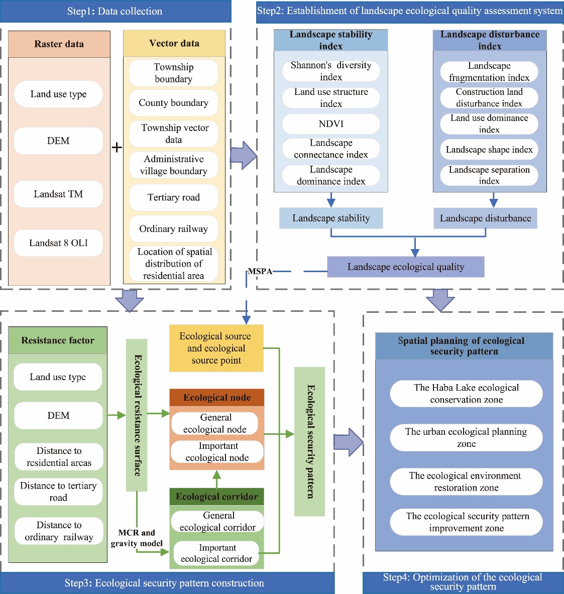
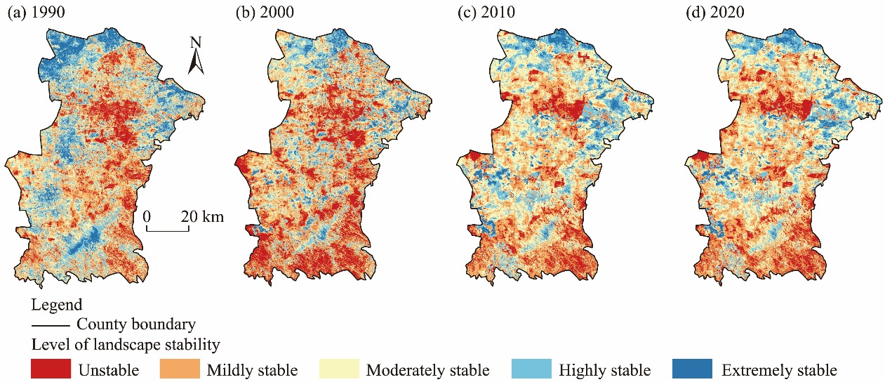
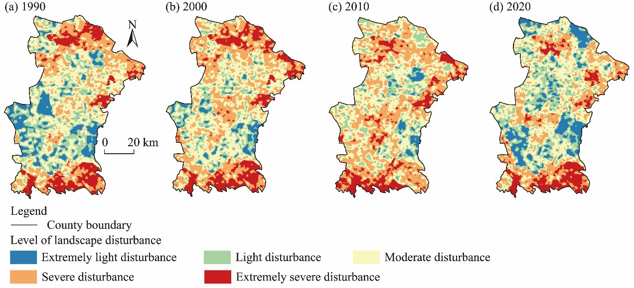
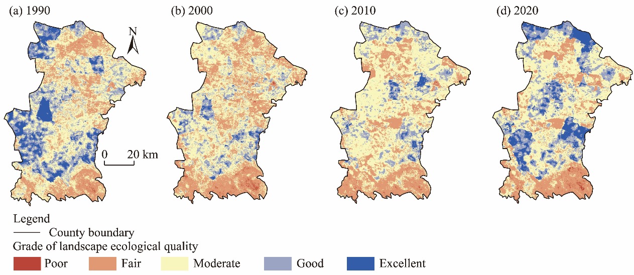
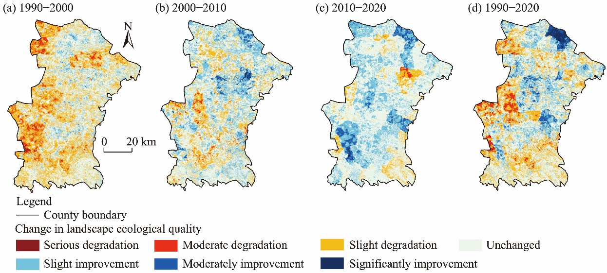
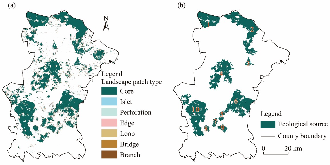
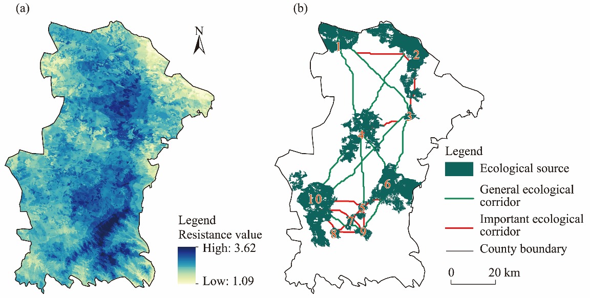
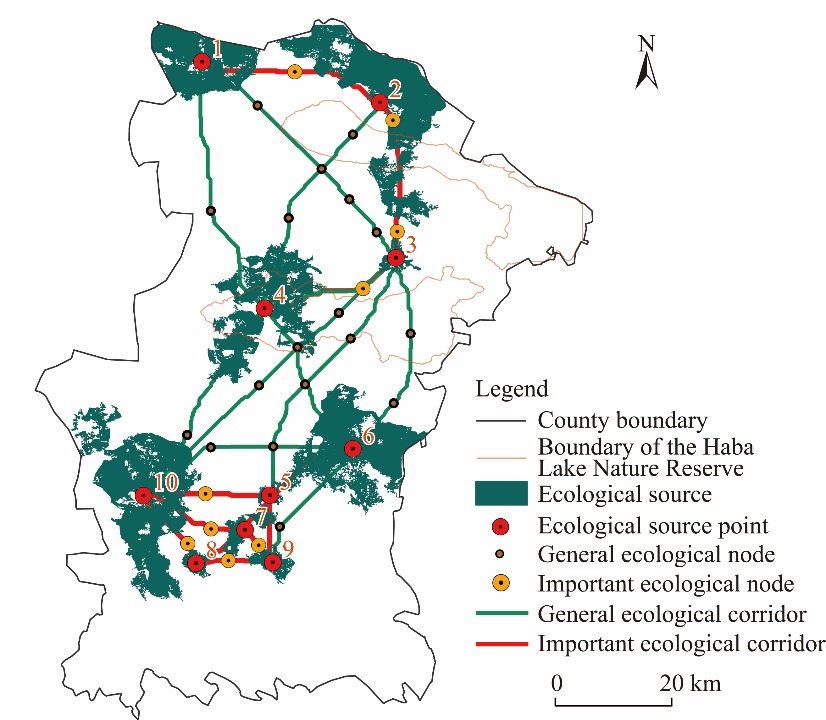
Abstract Ecological security patterns are paramount to the advancement of an ecological civilization in China, aiming to enhance the stability and service functions of ecosystems to achieve sustainable regional development. However, current regional ecological protection efforts have not been effectively integrated into the regional development planning of ecological security pattern. This study systematically assessed the effectiveness of ecological protection projects in Yanchi County, Ningxia Hui Autonomous Region, China, through the evaluation of landscape ecological quality. Based on the evaluation results of landscape ecological quality, this study used morphological pattern analysis (MSPA), minimum cumulative resistance (MCR) model, and gravity model together to construct the ecological security pattern of Yanchi County. The findings revealed that from 1990 to 2020, with the implementation of ecological protection projects started from 2000, the landscape stability of Yanchi County first decreased and then increased, and the intensity of landscape disturbance first intensified but then decreased, indicating an improvement in the landscape ecological quality and a significant enhancement of the ecological environment in Yanchi County. The ecological security pattern of Yanchi County consisted of 10 ecological sources, 10 ecological source points, 23 ecological corridors, and 27 ecological nodes. The ecological security pattern of Yanchi County exhibited distinct spatial variations, with stronger ecological security observed in the southern part than in northern part of the county. The ecological sources were denser in the southern part than in the northern part of the county, and accordingly, the length of ecological corridors was shorter and denser in the southern than that in the northern part of the county. Based on the spatial distribution of landscape ecological quality and the characteristics of ecological security pattern of Yanchi County in 2020, we suggested Yanchi County to build four zones to optimize the ecological security pattern construction: the Haba Lake ecological conservation zone, the urban ecological planning zone, the ecological environment restoration zone, and the ecological security improvement zone. This study can provide essential guidance for the construction of ecological security pattern in farming-pastoral areas both in China and worldwide.
|
|
Received: 17 July 2024
Published: 31 January 2025
|
|
Corresponding Authors:
*WANG Ya (E-mail: wangya2014@lzb.ac.cn)
|
|
|
| [1] |
Aragón R, Oesterheld M, Irisarri G, et al. 2011. Stability of ecosystem functioning and diversity of grasslands at the landscape scale. Landscape Ecology, 26: 1011-1022.
|
|
|
| [2] |
Bai H, Li Z W, Guo H L, et al. 2022. Urban green space planning based on remote sensing and geographic information systems. Remote Sensing, 14(17): 4213, doi: 10.3390/rs14174213.
|
|
|
| [3] |
Benedict M A, McMahon E T. 2002. Green infrastructure: smart conservation for the 21st century. Renewable Resources Journal, 20(3): 12-17.
|
|
|
| [4] |
Blaikie P. 2008. Epilogue: Towards a future for political ecology that works. Geoforum, 39(2): 765-772.
|
|
|
| [5] |
Cunha N S, Magalhães M R. 2019. Methodology for mapping the national ecological network to mainland Portugal: A planning tool towards a green infrastructure. Ecological Indicators, 104: 802-818.
doi: 10.1016/j.ecolind.2019.04.050
|
|
|
| [6] |
Dong J Q, Peng J, Liu Y X, et al. 2020. Integrating spatial continuous wavelet transform and kernel density estimation to identify ecological corridors in megacities. Landscape and Urban Planning, 199: 103815, doi: 10.1016/j.landurbplan.2020.103815.
|
|
|
| [7] |
Dong J Q, Jiang H, Gu T W, et al. 2022. Sustainable landscape pattern: a landscape approach to serving spatial planning. Landscape Ecology, 37: 31-42.
|
|
|
| [8] |
Field R D, Parrott L. 2017. Multi-ecosystem services networks: A new perspective for assessing landscape connectivity and resilience. Ecological Complexity, 32: 31-41.
|
|
|
| [9] |
Gao Y N, Zhao M L, Wang H L, et al. 2019. Analysis of spatial differentiation of grassland ecological quality and its affecting factors based on landscape ecology perspective: A case study of Siziwang Banner. Acta Ecologica Sinica, 39(14): 5288-5300. (in Chinese)
|
|
|
| [10] |
Gou M M, Li L, Ouyang S, et al. 2022. Integrating ecosystem service trade-offs and rocky desertification into ecological security pattern construction in the Daning River Basin of Southwest China. Ecological Indicators, 138: 108845, doi: 10.1016/j.ecolind.2022.108845.
|
|
|
| [11] |
Guo Z L, Hu Y C, Bai Y P. 2024. How to achieve ecological control zoning based on ecological security pattern (ESP)? A case study of China's coastal areas. Environmental Earth Sciences, 83(2): 57, doi: 10.1007/s12665-023-11362-8.
|
|
|
| [12] |
Hou C X, Zhou L H, Wen Y, et al. 2018. Evaluation of social-ecological systems resilience in ecological policy: a case study in Yanchi, Ningxia, China. China Population, Resources and Environment, 28(8): 117-126. (in Chinese)
|
|
|
| [13] |
Jia X Q, Fu B J, Feng X M, et al. 2014. The tradeoff and synergy between ecosystem services in the Grain-for-Green areas in northern Shaanxi, China. Ecological Indicators, 43: 103-113.
|
|
|
| [14] |
Jia Z Y, Chen C D, Tong X X, et al. 2017. Developing and optimizing ecological networks for the towns along the Three Gorges Reservoir: A case of Kaizhou New Town, Chongqing. Chinese Journal of Ecology, 36(3): 782-791. (in Chinese)
|
|
|
| [15] |
Lai J L, Li J S, Liu L. 2024. Optimization strategies for ecological security pattern based on the remote sensing ecological index in Yunnan Province, China. Land Degradation & Development, doi: 10.1002/ldr.5432.
|
|
|
| [16] |
Li L, Huang X J, Wu D F, et al. 2022. Optimization of ecological security patterns considering both natural and social disturbances in China's largest urban agglomeration. Ecological Engineering, 180: 106647, doi: 10.1016/j.ecoleng.2022.106647.
|
|
|
| [17] |
Li S C, Zhao Y L, Xiao Y, et al. 2020. Spatial and temporal differentiation of landscape ecological quality in Chaohu River Basin. Transactions of the Chinese Society for Agricultural Machinery, 51(1): 203-213. (in Chinese)
|
|
|
| [18] |
Li Y G, Liu W, Feng Q, et al. 2023. The role of land use change in affecting ecosystem services and the ecological security pattern of the Hexi Regions, Northwest China. Science of the Total Environment, 855: 158940, doi: 10.1016/j.scitotenv.2022.158940.
|
|
|
| [19] |
Liquete C, Kleeschulte S, Dige G, et al. 2015. Mapping green infrastructure based on ecosystem services and ecological networks: A Pan-European case study. Environmental Science & Policy, 54: 268-280.
|
|
|
| [20] |
Liu D, Lin N F, Zou C X, et al. 2015. Development of foreign ecological protected areas and linkages to ecological protection redline delineation and management in China. Biodiversity Science, 23(6): 708-715. (in Chinese)
doi: 10.17520/biods.2015131
|
|
|
| [21] |
Liu M L, Peng J, Dong J Q, et al. 2024. Trade-offs of landscape connectivity between regional and interregional ecological security patterns in a junction area of Beijing-Tianjin-Hebei region. Applied Geography, 167: 103272, doi: 10.1016/j.apgeog.2024.103272.
|
|
|
| [22] |
Luo M Y, Li T S. 2021. Spatial and temporal analysis of landscape ecological quality in Yulin. Environmental Technology & Innovation, 23: 101700, doi: 10.1016/j.eti.2021.101700.
|
|
|
| [23] |
Ma S C, Xie F F, Ding C, et al. 2020. Spatio-temporal change of landscape ecological quality and influencing factors based on four-quadrant model in overlapped area of cropland and coal production. Transactions of the Chinese Society of Agricultural Engineering (Transactions of the CSAE), 36(4): 259-268. (in Chinese)
|
|
|
| [24] |
Mandal M, Chatterjee N D. 2021. Forest landscape and its ecological quality: A stepwise spatiotemporal evaluation through patch-matrix model in Jhargram District, West Bengal State, India. Regional Sustainability, 2(2): 164-176.
|
|
|
| [25] |
Miao Z H, Pan L, Wang Q Z, et al. 2019. Research on urban ecological network under the threat of road networks—A case study of Wuhan. International Journal of Geo-Information, 8(8): 342, doi: 10.3390/ijgi8080342.
|
|
|
| [26] |
Montis A D, Caschili S, Mulas M, et al. 2016. Urban-rural ecological networks for landscape planning. Land Use Policy, 50: 312-327.
|
|
|
| [27] |
Ni Q L, Ding Z Y, Hou H P, et al. 2019. Ecological pattern recognition and protection based on circuit theory. Journal of Arid Land Resources and Environment, 33(5): 67-73. (in Chinese)
|
|
|
| [28] |
Palmer M, Ruhi A. 2019. Linkages between flow regime, biota, and ecosystem processes: Implications for river restoration. Science, 365(6459): eaaw2087, doi: 10.1126/science.aaw2087.
|
|
|
| [29] |
Peng J, Jia J L, Hu Y N, et al. 2018. Construction of ecological security pattern in the agro-pastoral ecotone based on surface humid index: A case study of Hangjin Banner, Inner Mongolia Autonomous Region, China. Chinese Journal of Applied Ecology, 29(6): 1990-1998. (in Chinese)
|
|
|
| [30] |
Penteado H M. 2013. Assessing the effects of applying landscape ecological spatial concepts on future habitat quantity and quality in an urbanizing landscape. Landscape Ecology, 28: 1909-1921.
|
|
|
| [31] |
Qian W Q, Zhao Y, Li X Y. 2023. Construction of ecological security pattern in coastal urban areas: A case study in Qingdao, China. Ecological Indicators, 154: 110754, doi: 10.1016/j.ecolind.2023.110754.
|
|
|
| [32] |
Qiao R R, Huang H T, Dong C Y, et al. 2023. Analysis of the influence of farmland pattern on landscape diversity in artificial oasis along the Yellow River in Ningxia: A case study in Zhongwei-Zhongning Plain Irrigation District. Journal of Desert Research, 43(2): 21-27. (in Chinese)
|
|
|
| [33] |
Ren G P, Liu L M, Zhuo D. 2016. Analysis of spatial differentiation of landscape ecological quality and its affecting factors in metropolitan suburbs. Transactions of the Chinese Society of Agricultural Engineering, 32(21): 252-263. (in Chinese)
|
|
|
| [34] |
Shi Y Y, Ji Y F, Zhang H J. 2018. Construction of suitability indicator system of Minqin oasis ecosystem. Agricultural Research in the Arid Areas, 36(6): 263-268. (in Chinese)
|
|
|
| [35] |
Su Q J, An Y L, Ma S B, et al. 2017. Landscape ecological quality of different lithological regions in karst mountains: A case study in the Luodian County of Guizhou Province. Carsologica Sinica, 36(4): 454-462. (in Chinese)
|
|
|
| [36] |
Tang F, Zhang P T, Zhang G J, et al. 2018. Construction of ecological corridors in Changli County based on ecological sensitivity and ecosystem service values. Chinese Journal of Applied Ecology, 29(8): 2675-2684. (in Chinese)
doi: 10.13287/j.1001-9332.201808.017
|
|
|
| [37] |
Tang F, Zhou X, Wang L, et al. 2021. Linking ecosystem service and MSPA to construct landscape ecological network of the Huaiyang Section of the Grand Canal. Land, 10(9): 919, doi: 10.3390/land10090919.
|
|
|
| [38] |
Wang T, Li H B, Huang Y. 2021a. The complex ecological network's resilience of the Wuhan metropolitan area. Ecological Indicators, 130: 108101, doi: 10.1016/j.ecolind.2021.108101.
|
|
|
| [39] |
Wang W W, Yang G J, Sun Y, et al. 2019. Linking prohibited grazing policy to farmers' subjective well-being: A case study in Yanchi County, China. Sustainability, 11(7): 2180, doi: 10.3390/su11072180.
|
|
|
| [40] |
Wang W W, Zhou L H, Sun Y, et al. 2021b. Influencing factors of farmers' life satisfaction under the background of grazing prohibition policy in Yanchi County, Ningxia Autonomous Region. Acta Ecologica Sinica, 41(23): 9282-9291. (in Chinese)
|
|
|
| [41] |
Wang Y, Zhou L H. 2016. Assessment of the coordination ability of sustainable social-ecological systems development based on a set pair analysis: A case study in Yanchi County, China. Sustainability, 8(8): 733, doi: 10.3390/su8080733.
|
|
|
| [42] |
Wei Q Q, Halike A, Yao K X, et al. 2022. Construction and optimization of ecological security pattern in Ebinur Lake Basin based on MSPA-MCR models. Ecological Indicators, 138: 108857, doi: 10.1016/j.ecolind.2022.108857.
|
|
|
| [43] |
Wei X, Zhou L H, Yang G J, et al. 2020. Assessing the effects of desertification control projects from the farmers' perspective: A case study of Yanchi County, Northern China. International Journal of Environmental Research and Public Health, 17(3): 983, doi: 10.3390/ijerph17030983.
|
|
|
| [44] |
Wu S Y, Zhao C, Yang L, et al. 2024. Spatial and temporal evolution analysis of ecological security pattern in Hubei Province based on ecosystem service supply and demand analysis. Ecological Indicators, 162: 112051, doi: 10.1016/j.ecolind.2024.112051.
|
|
|
| [45] |
Xiao L, Cui L, Jiang Q O, et al. 2020. Spatial structure of a potential ecological network in Nanping, China, based on ecosystem service functions. Land, 9(10): 376, doi: 10.3390/land9100376.
|
|
|
| [46] |
Xiao R, Cao W, Liu Y, et al. 2022. The impacts of landscape patterns spatio-temporal changes on land surface temperature from a multi-scale perspective: A case study of the Yangtze River Delta. Science of the Total Environment, 821: 153381, doi: 10.1016/j.scitotenv.2022.153381.
|
|
|
| [47] |
Xu J X, Zhao H, Yin P C, et al. 2019. Landscape ecological quality assessment and its dynamic change in coal mining area: a case study of Peixian. Environmental Earth Sciences, 78: 708, doi: 10.1007/s12665-019-8747-5.
|
|
|
| [48] |
Xu T, Nie W B, Wang Z G, et al. 2024. Research on the coupled mechanism of landscape connectivity simulation by integrating multi-level ecological security patterns and multi-scenario simulation: A case study of the main urban area of Hangzhou. Land Degradation & Development, 35(8): 2716-2737.
|
|
|
| [49] |
Xu W X, Wang J M, Zhang M, et al. 2021. Construction of landscape ecological network based on landscape ecological risk assessment in a large-scale opencast coal mine area. Journal of Cleaner Production, 286: 125523, doi: 10.1016/j.jclepro.2020.125523.
|
|
|
| [50] |
Xue F, Yang Y R, Hu Y N. 2024. Integrating supply and benefits of ecosystem services into ecological security pattern: A spatial flow perspective. Ecological Indicators, 166: 112455, doi: 10.1016/j.ecolind.2024.112455.
|
|
|
| [51] |
Xue J, Li Z X, Feng Q, et al. 2023. Construction of ecological conservation pattern based on ecosystem services of Three River Headwaters, Western China. Global Ecology and Conservation, 44: e02491, doi: 10.1016/j.gecco.2023.e02491.
|
|
|
| [52] |
Yang J, Xie B P, Wang T B, et al. 2023. Identification and optimization strategy of ecological security pattern in Maiji District of Gansu, China. Ecological Indicators, 157: 111309, doi: 10.1016/j.ecolind.2023.111309.
|
|
|
| [53] |
Yang J X, Deng W, Zhang G H, et al. 2024. Linking endangered species protection to construct and optimize ecological security patterns in the national ecological civilization construction demonstration zone: A case study of Yichang, China. Ecological Indicators, 158: 111579, doi: 10.1016/j.ecolind.2024.111579.
|
|
|
| [54] |
Yang Q K, Wang L, Li Y L, et al. 2021. Urban spatial expansion mode based on the construction of landscape ecological security pattern: A case of the coastal area of Jiangsu. Scientia Geographica Sinica, 41(5): 737-746. (in Chinese)
doi: 10.13249/j.cnki.sgs.2021.05.001
|
|
|
| [55] |
Yang X, Pu Y W, Weng S G, et al. 2022. Review of agricultural water-saving policies and measures in recent years—a case study of Jiangsu Province, China. Water Supply, 22(4): 3951-3967.
|
|
|
| [56] |
Ye X, Zou C X, Liu G H, et al. 2018. Main research contents and advances in the ecological security pattern. Acta Ecologica Sinica, 38(10): 3382-3392. (in Chinese)
|
|
|
| [57] |
Ye Y Y, Su Y X, Zhang H O, et al. 2015. Construction of an ecological resistance surface model and its application in urban expansion simulations. Journal of Geographical Sciences, 25: 211-224.
doi: 10.1007/s11442-015-1163-1
|
|
|
| [58] |
Yi L, Sun Y, Yin S H, et al. 2022. Construction of ecological security pattern: Concept, framework and prospect. Ecology and Environmental Sciences, 31(4): 845-856. (in Chinese)
|
|
|
| [59] |
Yin H W, Kong F H, Qi Y, et al. 2011. Developing and optimizing ecological networks in urban agglomeration of Hunan Province, China. Acta Ecologica Sinica, 31(10): 2863-2874. (in Chinese)
|
|
|
| [60] |
Zeng W T, He Z W, Bai W Q, et al. 2024. Identification of ecological security patterns of alpine wetland grasslands based on landscape ecological risks: A study in Zoigê County. Science of the Total Environment, 928: 172302, doi: 10.1016/j.scitotenv.2024.172302.
|
|
|
| [61] |
Zetterberg A, Mortberg U M, Balfors B. 2010. Making graph theory operational for landscape ecological assessments, planning, and design. Landscape and Urban Planning, 95(4): 181-191.
|
|
|
| [62] |
Zhang D C, Wang Z M, Li Y J, et al. 2024. Research on the index system and evaluation method for ecological services of river shorelines. Journal of Environmental Engineering Technology, 14(1): 289-297.
|
|
|
| [63] |
Zhang H T, Li J L, Tian P, et al. 2022a. Construction of ecological security patterns and ecological restoration zones in the city of Ningbo, China. Journal of Geographical Sciences, 32(4): 663-681.
|
|
|
| [64] |
Zhang R, Zhang Q P, Zhang L, et al. 2022b. Identification and extraction of a current urban ecological network in Minhang District of Shanghai based on an optimization method. Ecological Indicators, 136: 108647, doi: 10.1016/j.ecolind.2022.108647.
|
|
|
| [65] |
Zhang Y Z, Jiang Z Y, Li Y Y, et al. 2021. Construction and optimization of an urban ecological security pattern based on habitat quality assessment and the minimum cumulative resistance model in Shenzhen City, China. Forests, 12(7): 847, doi: 10.3390/f12070847.
|
|
|
| [66] |
Zhao S M, Ma Y F, Wang J L, et al. 2019. Landscape pattern analysis and ecological network planning of Tianjin City. Urban Forestry & Urban Green, 46: 126479, doi: 10.1016/j.ufug.2019.126479.
|
|
|
| [67] |
Zou S J, Zhang L, Huang X, et al. 2022. Early ecological security warning of cultivated lands using RF-MLP integration model: A case study on China's main grain-producing areas. Ecological Indicators, 141: 109059, doi: 10.1016/j.ecolind.2022.109059.
|
|
|
|
Viewed |
|
|
|
Full text
|
|
|
|
|
Abstract
|
|
|
|
|
Cited |
|
|
|
|
| |
Shared |
|
|
|
|
| |
Discussed |
|
|
|
|