| Research article |
|


|
|
|
| Loess shoulder-line extraction based on bidimensional empirical mode decomposition and edge detection |
WU Han, LI Jilong*( ), CUI Tianjiao, WANG Xianle, HE Shan |
| School of Geography and Planning, Ningxia University, Yinchuan 750021, China |
|
|
|
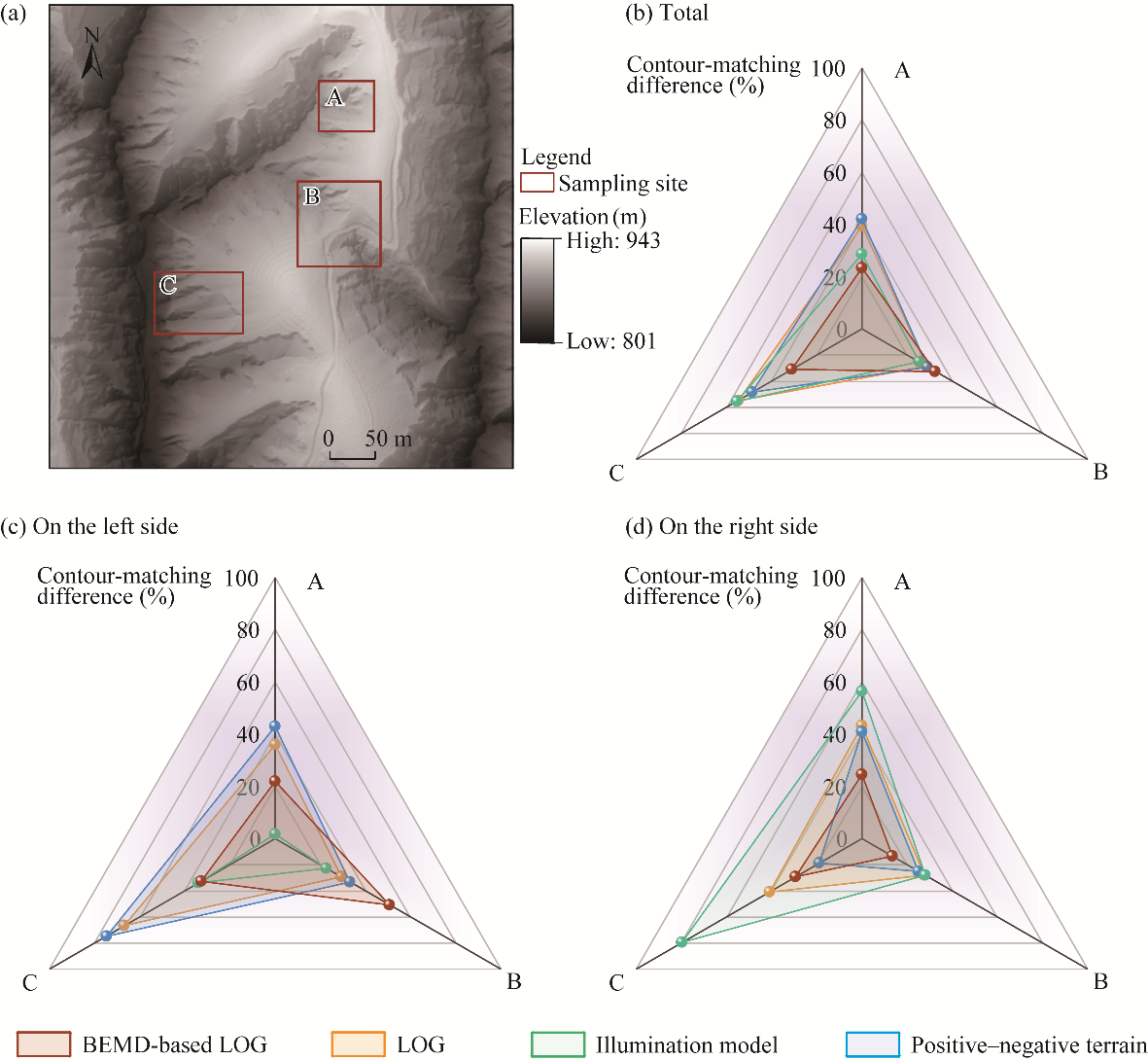
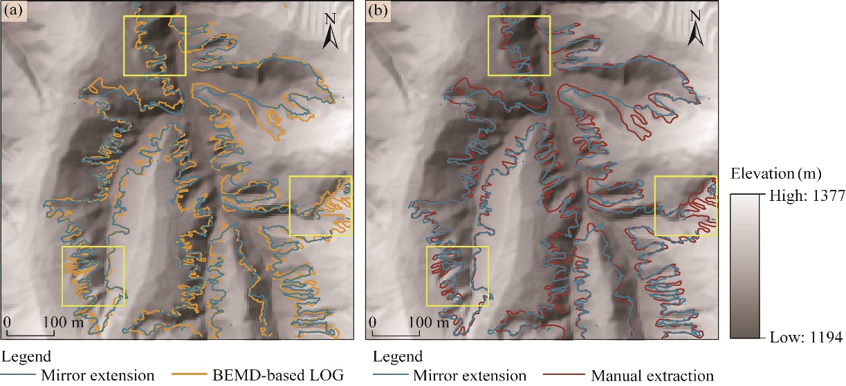
Abstract Shoulder-lines are topographic features of loess landforms, and their dynamic changes visually reflect differences in gully erosion status and processes on the Chinese Loess Plateau. Therefore, accurate shoulder-line extraction is important for understanding loess landforms. However, existing extraction methods cannot sufficiently record loess shoulder-line details, reducing extraction accuracy. Based on digital elevation model (DEM) data acquired in 2013 and 2016, this study systematically analyzed the loess shoulder-line morphology in a small watershed on the Chinese Loess Plateau. We integrated theoretical approaches (e.g., signal processing) with bidimensional empirical mode decomposition (BEMD) combined with edge detection (Laplacian of Gaussian (LOG) operator) to automatically extract loess shoulder-lines, and assessed the extraction accuracy through a comparison with three methods (LOG, illumination model, and positive-negative terrain) from existing studies and manual extraction results. The proposed method transformed loess landform research from the spatial domain to the frequency domain. BEMD combined with edge detection effectively revealed shoulder-line features while maintaining the local completeness of shoulder-lines, specifically in areas with high terrain complexity or curvature. The extraction accuracy was 90.11% in the study area, with a mean absolute error (MAE) of 0.8040 m and a median absolute error (MedAE) of 1 m. When applied to different loess landform types, the method demonstrated broad universality and feasibility. The extraction accuracy exceeded 95.00% in the loess tableland watershed, and reached 91.90% in the loess hill watershed. Thus, our proposed method provides a novel perspective for shoulder-line extraction, which can effectively characterize changes in loess landforms at different scales and ensure the automation and high accuracy of shoulder-line extractions. Ultimately, this study is expected to advance gully erosion research on the Chinese Loess Plateau from a frequency-domain perspective.
|
|
Received: 09 December 2025
Published: 30 November 2026
|
|
Corresponding Authors:
*LI Jilong (E-mail: lijilong@nxu.edu.cn)
|
| About author: Author contributions
Conceptualization: LI Jilong; Methodology: WU Han, CUI Tianjiao, HE Shan; Investigation: WU Han, LI Jilong; Formal analysis: WU Han; Writing - original draft preparation: WU Han; Writing - review and editing: LI Jilong, CUI Tianjiao, HE Shan, WANG Xianle; Funding acquisition: LI Jilong; Resources: LI Jilong; Supervision: LI Jilong; Visualization: WU Han, CUI Tianjiao, HE Shan, WANG Xianle. All authors approved the manuscript.
|
|
|
| [1] |
Abbas N H, Ahmad S M S, Parveen S, et al. 2018. Design of high performance copyright protection watermarking based on lifting wavelet transform and bi empirical mode decomposition. Multimedia Tools and Applications, 77(19): 24593-24614.
|
|
|
| [2] |
An F P, Lin D C, Zhou X W, et al. 2015. Enhancing image denoising performance of bidimensional empirical mode decomposition by improving the edge effect. International Journal of Antennas and Propagation, 2015: 769478, doi: 10.1155/2015/769478.
|
|
|
| [3] |
Ayenu-Prah A, Attoh-Okine N. 2008. Evaluating pavement cracks with bidimensional empirical mode decomposition. EURASIP Journal on Advances in Signal Processing, 2008: 861701, doi: 10.1155/2008/861701.
|
|
|
| [4] |
Canny J. 1986. A computational approach to edge detection. IEEE Transactions on Pattern Analysis and Machine Intelligence, 8(6): 679-698.
|
|
|
| [5] |
Cao J J, Na J M, Li J L, et al. 2017. Topographic spatial variation analysis of loess shoulder lines in the Loess Plateau of China based on MF-DFA. ISPRS International Journal of Geo-Information, 6(5): 141, doi: 10.3390/ijgi6050141.
|
|
|
| [6] |
Chen R, Zhou Y, Wang Z T, et al. 2024. Towards accurate mapping of loess waterworn gully by integrating Google Earth imagery and DEM using deep learning. International Soil and Water Conservation Research, 12(1): 13-28.
|
|
|
| [7] |
Chen Y, Yang X, Fu H J X, et al. 2025. Characterizing spatial patterns and regionalization of anthropogenic landforms using multi-source geospatial data: Insights from Loess Plateau of China. Geomorphology, 478: 109708, doi: 10.1016/j.geomorph.2025.109708.
|
|
|
| [8] |
Dai W, Na J M, Huang N, et al. 2019a. Integrated edge detection and terrain analysis for agricultural terrace delineation from remote sensing images. International Journal of Geographical Information Science, 34(3): 484-503.
|
|
|
| [9] |
Dai W, Yang X, Na J M, et al. 2019b. Effects of DEM resolution on the accuracy of gully maps in loess hilly areas. CATENA, 177: 114-125.
|
|
|
| [10] |
Ding H, Liu K, Chen X Z, et al. 2020. Optimized segmentation based on the weighted aggregation method for loess bank gully mapping. Remote Sensing, 12(5): 793, doi: 10.3390/rs12050793.
|
|
|
| [11] |
Gawrysiak L, Kociuba W. 2023. LiDAR-derived relief typology of loess patches (East Poland). Remote Sensing, 15(7): 1875, doi: 10.3390/rs15071875.
|
|
|
| [12] |
Han L, Zhao Z L, Yang M L, et al. 2023. Research progress and prospects of gully shoulder line in the Loess Plateau. Science of Soil and Water Conservation, 21(6): 131-143. (in Chinese)
|
|
|
| [13] |
Huang N E, Shen Z, Long S R, et al. 1998. The empirical mode decomposition and the Hilbert spectrum for nonlinear and non-stationary time series analysis. Proceedings of the Royal Society A, 454(1971): 903-995.
|
|
|
| [14] |
Jiang S, Tang G A, Liu K. 2015. A new extraction method of loess shoulder-line based on Marr-Hildreth operator and terrain mask. PLoS ONE, 10(4): e0123804, doi: 10.1371/journal.pone.0123804.
|
|
|
| [15] |
Jiao H Y, Li F Y, Wei H, et al. 2022. An improved shoulder line extraction method fusing edge detection and regional growing algorithm. Applied Sciences, 12(24): 12662, doi: 10.3390/app122412662.
|
|
|
| [16] |
Jing J F, Liu S J, Wang G, et al. 2022. Recent advances on image edge detection: A comprehensive review. Neurocomputing, 503: 259-271.
|
|
|
| [17] |
Li C R, Yang X, Liu H L, et al. 2022. Spatial distribution characteristics of discontinuous hillslope gullies on the Loess Plateau of China: A special focus on spoon gullies. CATENA, 215: 106327, doi: 10.1016/j.catena.2022.106327.
|
|
|
| [18] |
Li J L, Na J M, Yang X, et al. 2019. Application of the Hilbert-Huang transform for recognition of active gully erosion sites in the Loess Plateau of China. Transactions in GIS, 23(1): 137-157.
|
|
|
| [19] |
Li J S, Li X Z, Wei W, et al. 2020. Relative vibration identification of cutter and workpiece based on improved bidimensional empirical mode decomposition. Frontiers of Mechanical Engineering, 15(2): 227-239.
|
|
|
| [20] |
Li S J, Xiong L Y, Li Y, et al. 2024. A multilevel dataset of landform mapping and geomorphologic descriptors for the Loess Plateau of China. Scientific Data, 11(1): 1282, doi: 10.1038/s41597-024-04027-z.
|
|
|
| [21] |
Liang L F, Liu Z H. 2024. Fringe pattern preprocessing via adaptive multidirectional empirical mode decomposition. Optics Express, 32(24): 43512-43533.
|
|
|
| [22] |
Lin S W, Chen N, He Z W. 2021. Automatic landform recognition from the perspective of watershed spatial structure based on digital elevation models. Remote Sensing, 13(19): 3926, doi: 10.3390/rs13193926.
|
|
|
| [23] |
Lin S W, Xie J, Deng J Y, et al. 2022. Landform classification based on landform geospatial structure-a case study on Loess Plateau of China. International Journal of Digital Earth, 15(1): 1125-1148.
|
|
|
| [24] |
Liu K, Ding H, Tang G A, et al. 2016. Detection of catchment-scale gully-affected areas using unmanned aerial vehicle (UAV) on the Chinese Loess Plateau. ISPRS International Journal of Geo-Information, 5(12): 238, doi: 10.3390/ijgi5120238.
|
|
|
| [25] |
Liu K, Na J M, Fan C Y, et al. 2022. Large-scale detection of the tableland areas and erosion-vulnerable hotspots on the Chinese Loess Plateau. Remote Sensing, 14(8): 1946, doi: 10.3390/rs14081946.
|
|
|
| [26] |
Liu P J, Zhu Q K, Wu D L, et al. 2006. Automated extraction of shoulder line of valleys based on flow paths from grid Digital Elevation Model (DEM) data. Journal of Beijing Forestry University, 28(4): 72-76. (in Chinese)
|
|
|
| [27] |
Liu Y, Chu Y Z, Zhu L, et al. 2026. Automatic extraction of gully edge lines in loess tableland areas based on machine learning. Geography and Geo-Information Science, 42(1): 1-8. (in Chinese)
|
|
|
| [28] |
Liu Z H, Zhang H M, Dong L, et al. 2023. An optimised region-growing algorithm for extraction of the Loess shoulder-line from DEMs. ISPRS International Journal of Geo-Information, 12(4): 140, doi: 10.3390/ijgi12040140.
|
|
|
| [29] |
Luo Z D, Liu E J, Qi S, et al. 2019. Method of gully extraction based on optimized geomorphological features and texture information in Loess Plateau. Transactions of the Chinese Society for Agricultural Machinery, 50(1): 285-291. (in Chinese)
|
|
|
| [30] |
Ma M, Wang C H, Li X, et al. 2019. Aeromagnetic anomalies interpretation based on improved bi-dimensional empirical mode decomposition (BEMD) and RGB composition. IOP Conference Series: Earth and Environmental Science, 237(5): 052002, doi: 10.1088/1755-1315/237/5/052002.
|
|
|
| [31] |
Marr D, Hildreth E. 1980. Theory of edge detection. Proceedings of the Royal Society B, 207(1167): 187-217.
|
|
|
| [32] |
Mini P B, Bhomini P A. 2024. A study in enhancement of satellite images. Engineering Applications of Artificial Intelligence, 138: 109259, doi: 10.1016/j.engappai.2024.109259.
|
|
|
| [33] |
Na J M, Yang X, Dai W, et al. 2018. Bidirectional DEM relief shading method for extraction of gully shoulder line in loess tableland area. Physical Geography, 39(4): 368-386.
|
|
|
| [34] |
Nunes J C, Bouaoune Y, Delechelle E, et al. 2003. Image analysis by bidimensional empirical mode decomposition. Image and Vision Computing, 21(12): 1019-1026.
|
|
|
| [35] |
Nunes J C, Guyot S, Deléchelle E. 2005. Texture analysis based on local analysis of the bidimensional empirical mode decomposition. Machine Vision and Applications, 16: 177-188.
|
|
|
| [36] |
Panda M K, Thangaraj V, Subudhi B N, et al. 2024. Bayesian's probabilistic strategy for feature fusion from visible and infrared images. The Visual Computer, 40(6): 4221-4233.
|
|
|
| [37] |
Prakash N, Manconi A, Loew S. 2020. Mapping landslides on EO data: Performance of deep learning models vs. traditional machine learning models. Remote Sensing, 12(3): 346, doi: 10.3390/rs12030346.
|
|
|
| [38] |
Song X D, Tang G A, Li F Y, et al. 2013. Extraction of loess shoulder-line based on the parallel GVF snake model in the loess hilly area of China. Computers & Geosciences, 52: 11-20.
|
|
|
| [39] |
Tang G A, Tao Y, Wang C. 2007. Contour-matching-difference and its application in DEM quality assessment. Bulletin of Surveying and Mapping, 7: 5-67. (in Chinese)
|
|
|
| [40] |
Tang J, Li D, Zhang L, et al. 2024. Feature extraction of hyperspectral images based on SVM optimization of 2D-EMD and GWO. Journal of Measurements in Engineering, 12(4): 548-561.
|
|
|
| [41] |
Utsumi A G, Tarlé Pissarra T C, Rosalen D L, et al. 2020. Gully mapping using geographic object-based image analysis: A case study at catchment scale in the Brazilian Cerrado. Remote Sensing Applications: Society and Environment, 20: 100399, doi: 10.1016/j.rsase.2020.100399.
|
|
|
| [42] |
Wang H, Hu G H, Ma J F, et al. 2023. Classifying slope unit by combining terrain feature lines based on digital elevation models. Land, 12(1): 193, doi: 10.3390/land12010193.
|
|
|
| [43] |
Wang L. 2013. Spatial frequency spectrum analysis of erosion gullies in small watershed scale of Loess Plateau. PhD Dissertation. Yangling: Research Center of Soil and Water Conservation and Ecological Environment, Chinese Academy of Sciences and Ministry of Education. (in Chinese)
|
|
|
| [44] |
Wu Q L, Jiang X H, Shi X W, et al. 2024a. Spatiotemporal evolution characteristics of soil erosion and its driving mechanisms-a case study: Loess Plateau, China. CATENA, 242: 108075, doi: 10.1016/j.catena.2024.108075.
|
|
|
| [45] |
Wu Y N, Chang J, Ji Z Y, et al. 2024b. Optical asymmetric cryptosystem based on dynamic foveated imaging and bidimensional empirical mode decomposition. Photonics, 11(2): 105, doi: 10.3390/photonics11020105.
|
|
|
| [46] |
Xiong L Y, Tang G A. 2020. Research progresses and prospects of gully landform formation and evolution in the Loess Plateau of China. Journal of Geo-information Science, 22(4): 816-826. (in Chinese)
|
|
|
| [47] |
Yan G, Tang G A, Chen J, et al. 2024. Modeling computer sight based on DEM data to detect terrain breaks caused by gully erosion on the Loess Plateau. CATENA, 237: 107837, doi: 10.1016/j.catena.2024.107837.
|
|
|
| [48] |
Yan S J, Tang G A, Li F Y, et al. 2011. An edge detection based method for extraction of loess shoulder-line from grid DEM. Geomatics and Information Science of Wuhan University, 36(3): 363-367.
|
|
|
| [49] |
Yang B, Ma X W, Jiao J Y, et al. 2024. Magnitude and hotspots of soil erosion types during heavy rainstorm events on the Loess Plateau: Implications for watershed management. CATENA, 246: 108365, doi: 10.1016/j.catena.2024.108365.
|
|
|
| [50] |
Yuan S Q, Fan W, Jiang C C. 2023. The profiles based on ridge and valley lines to extract shoulder lines on the Loess Plateau. Remote Sensing, 15(2): 380, doi: 10.3390/rs15020380.
|
|
|
| [51] |
Yuan S Q, Fan W, Jiang C C, et al. 2025. Active gully head erosion rates characteristics on the Loess Plateau: InSAR-based calculation and response to extreme rainfall. Land Degradation & Development, 36(1): 249-264.
|
|
|
| [52] |
Zhang L, Tang G A, Li F Y, et al. 2012. A review on research of loess shoulder-line. Geography and Geo-Information Science, 28(6): 44-48. (in Chinese)
|
|
|
| [53] |
Zhang Z Q, Wang G W, Carranza E J M, et al. 2019. Metallogenic model of the Wulong gold district, China, and associated assessment of exploration criteria based on multi-scale geoscience datasets. Ore Geology Reviews, 114: 103138, doi: 10.1016/j.oregeorev.2019.103138.
|
|
|
| [54] |
Zhao Y L, Gao J M, Dang C Y, et al. 2016. An edge enhancement method of radiographic weld image using bidimensional empirical mode decomposition. In: 2016 IEEE International Conference of Online Analysis and Computing Science, 2016: 24-28.
|
|
|
| [55] |
Zhou Y, Tang G A, Yang X, et al. 2010. Positive and negative terrains on northern Shaanxi Loess Plateau. Journal of Geographical Sciences, 20: 64-76.
|
|
|
| [56] |
Zhu H C, Tang G A, Qian K J, et al. 2014. Extraction and analysis of gully head of Loess Plateau in China based on digital elevation model. Chinese Geographical Science, 24: 328-338.
|
|
|
|
Viewed |
|
|
|
Full text
|
|
|
|
|
Abstract
|
|
|
|
|
Cited |
|
|
|
|
| |
Shared |
|
|
|
|
| |
Discussed |
|
|
|
|