| Research article |
|

|
|
|
| Automatic classification of coastal sand dunes in the Namib Desert through the texture analysis approach |
JIN Zikai1,2,3, LI Fayuan1,2,3,*( ), LIU Lulu1,4, JIAO Haoyang1,2,3, CUI Lingzhou5 ), LIU Lulu1,4, JIAO Haoyang1,2,3, CUI Lingzhou5 |
1School of Geography, Nanjing Normal University, Nanjing 210023, China
2Key Laboratory of Virtual Geographic Environment, Ministry of Education, Nanjing Normal University, Nanjing 210023, China
3Jiangsu Centre for Collaborative Innovation in Geographical Information Resource Development and Application, Nanjing 210023, China
4Ningbo Institute of Surveying, Mapping and Remote Sensing, Ningbo 315042, China
5College of Life and Environmental Science, Wenzhou University, Wenzhou 325035, China |
|
|
|
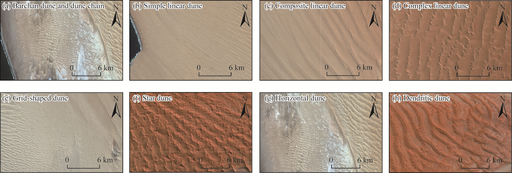
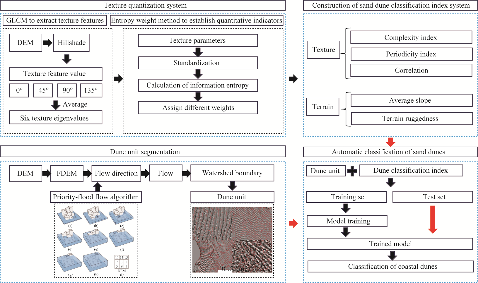
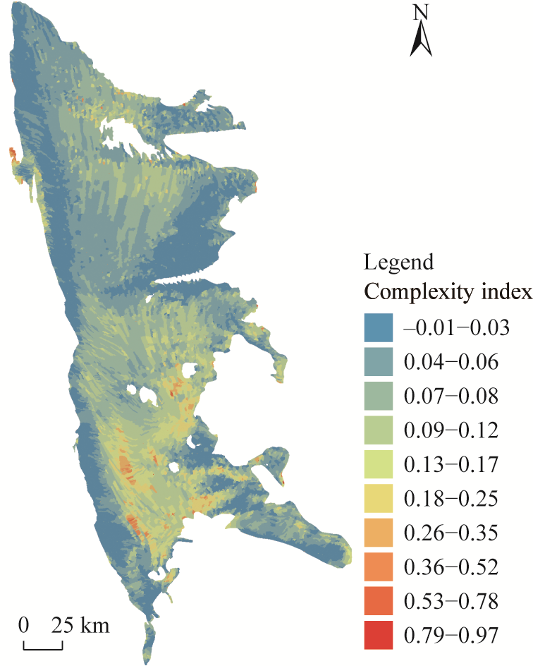
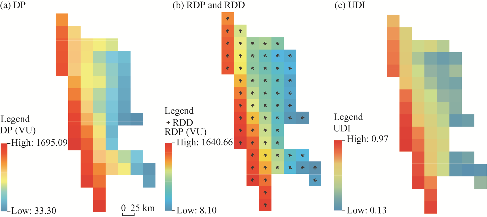
Abstract Texture analysis methods offer substantial advantages and potential in examining macro-topographic features of dunes. Despite these advantages, comprehensive approaches that integrate digital elevation model (DEM) with quantitative texture features have not been fully developed. This study introduced an automatic classification framework for dunes that combines texture and topographic features and validated it through a typical coastal aeolian landform, namely, dunes in the Namib Desert. A three-stage approach was outlined: (1) segmentation of dune units was conducted using digital terrain analysis; (2) six texture features (angular second moment, contrast, correlation, variance, entropy, and inverse difference moment) were extracted from the gray-level co-occurrence matrix (GLCM) and subsequently quantified; and (3) texture-topographic indices were integrated into the random forest (RF) model for classification. The results show that the RF model fused with texture features can accurately identify dune morphological characteristics; through accuracy evaluation and remote sensing image verification, the overall accuracy reaches 78.0% (kappa coefficient=0.72), outperforming traditional spectral-based methods. In addition, spatial analysis reveals that coastal dunes exhibit complex texture patterns, with texture homogeneity being closely linked to dune-type transitions. Specifically, homogeneous textures correspond to simple and stable forms such as barchans, while heterogeneous textures are associated with complex or composite dunes. The complexity, periodicity, and directionality of texture features are highly consistent with the spatial distribution of dunes. Validation using high-resolution remote sensing imagery (Sentinel-2) further confirms that the method effectively clusters similar dunes and distinguishes different dune types. Additionally, the dune classification results have a good correspondence with changes in near-surface wind regimes. Overall, the findings suggest that texture features derived from DEM can accurately capture the dynamic characteristics of dune morphology, offering a novel approach for automatic dune classification. Compared with traditional methods, the developed approach facilitates large-scale and high-precision dune mapping while reducing the workload of manual interpretation, thus advancing research on aeolian geomorphology.
|
|
Received: 14 April 2025
Published: 31 August 2025
|
|
Corresponding Authors:
*LI Fayuan (E-mail: lifayuan@njnu.edu.cn)
|
|
|
| [1] |
Abbasi H R, Opp C, Groll M, et al. 2019. Assessment of the distribution and activity of dunes in Iran based on mobility indices and ground data. Aeolian Research, 41: 100539, doi: 10.1016/j.aeolia.2019.07.005.
|
|
|
| [2] |
Al-Masrahy M A, Mountney N P. 2015. A classification scheme for fluvial-aeolian system interaction in desert-margin settings. Aeolian Research, 17: 67-88.
|
|
|
| [3] |
Almutlaq F, Mulligan K. 2023. Using texture statistics to identify and map different dune types within the Rub'al Khali. Remote Sensing, 15(19): 4653, doi: 10.3390/rs15194653.
|
|
|
| [4] |
Bandeira L, Marques J S, Saraiva J, et al. 2013. Advances in automated detection of sand dunes on Mars. Earth Surface Processes and Landforms, 38(3): 275-283.
|
|
|
| [5] |
Bauer B O, Davidson-Arnott R G D, Walker I J, et al. 2012. Wind direction and complex sediment transport response across a beach-dune system. Earth Surface Processes and Landforms, 37(15): 1661-1677.
|
|
|
| [6] |
Bergen J R, Adelson E H. 1988. Early vision and texture perception. Nature, 333(6171): 363-364.
|
|
|
| [7] |
Beveridge C, Kocurek G, Ewing R C, et al. 2006. Development of spatially diverse and complex dune-field patterns: Gran Desierto Dune Field, Sonora, Mexico. Sedimentology, 53(6): 1391-1409.
|
|
|
| [8] |
Breed C S, Grow T. 1979. Morphology and distribution of dunes in sand seas observed by remote sensing. In: McKee E D. A Study of Global Sand Seas: United States Geological Survey Professional Paper 1052. Washington D.C.: United States Government Printing Office, 253-302.
|
|
|
| [9] |
Breiman L. 2001. Random forests. Machine Learning, 45: 5-32.
|
|
|
| [10] |
Carter R W G, Wilson P. 1991. Chronology and geomorphology of the Irish dunes. In: Quigley M B. A Guide to the Sand Dunes of Ireland. Leiden: European Union for Dune Conservation and Coastal Management, 18-41.
|
|
|
| [11] |
Chen P Y. 2019. Effects of normalization on the entropy-based TOPSIS method. Expert Systems with Applications, 136: 33-41.
doi: 10.1016/j.eswa.2019.06.035
|
|
|
| [12] |
Chen Y B, Li T Y, Li X Y, et al. 2022. On the relationship between the precipitation cloud spectrum and precipitation in typhoon based on random forest model and remote sensing. Remote Sensing Technology and Application, 37(5): 1277-1288. (in Chinese)
|
|
|
| [13] |
Chowdhury P R, Deshmukh B, Goswami A K, et al. 2010. Neural network-based dunal landform mapping from multi-spectral images using texture features. IEEE Journal of Selected Topics in Applied Earth Observations and Remote Sensing, 4(1): 171-184.
|
|
|
| [14] |
Clausi D A, Jernigan M E. 1998. A fast method to determine co-occurrence texture features. IEEE Transactions on Geoscience and Remote Sensing, 36(1): 298-300.
|
|
|
| [15] |
Davis R J. 2012. Coastal Sedimentary Environments. Berlin: Springer, 303-378.
|
|
|
| [16] |
Derickson D, Kocurek G, Ewing R C, et al. 2008. Origin of a complex and spatially diverse dune-field pattern, Algodones, southeastern California. Geomorphology, 99(1-4): 186-204.
|
|
|
| [17] |
Feilberg A, Jensen F. 1992. Management and Conservation of Sand Dunes in Denmark. Berlin: Springer, 127-148.
|
|
|
| [18] |
Friedman G M. 1961. Distinction between dune, beach, and river sands from their textural characteristics. Journal of Sedimentary Research, 31(4): 514-529.
|
|
|
| [19] |
Fryberger S G, Dean G. 1979. Dune forms and wind regime. In: McKee E D. A Study of Global Sand Seas: United States Geological Survey Professional Papers1052. Washington D. C.: United States Government Printing Office, 137-169.
|
|
|
| [20] |
Gadhiraju S V, Shah V, Buddhiraju K M. 2014. Segmentation of desert sand dunes. Remote Sensing Letters, 5(11): 961-970.
|
|
|
| [21] |
Garzanti E, Vermeesch P, Andò S, et al. 2013. Provenance and recycling of Arabian desert sand. Earth-Science Reviews, 120: 1-19.
|
|
|
| [22] |
Geng J, Yu Y, Tan Q Y, et al. 2025. Disentangling natural and anthropogenic influences on the spatial variability of soil cadmium contamination. Environmental Pollution, 384: 126946, doi: 10.1016/j.envpol.2025.126946.
|
|
|
| [23] |
Gholami H, Mohamadifar A, Rahimi S, et al. 2021. Predicting land susceptibility to atmospheric dust emissions in central Iran by combining integrated data mining and a regional climate model. Atmospheric Pollution Research, 12(4): 172-187.
|
|
|
| [24] |
Gu L X, Lü P, Ma F, et al. 2022. Drift potential characteristics of Mu Us Sandy Land calculated with different data sources. Journal of Desert Research, 42(5): 54-62. (in Chinese)
doi: 10.7522/j.issn.1000-694X.2022.00014
|
|
|
| [25] |
Haralick R M, Shanmugam K, Dinstein I H. 1973. Textural features for image classification. IEEE Transactions on Systems, Man, and Cybernetics, 6: 610-621.
|
|
|
| [26] |
Haralick R M. 1979. Statistical and structural approaches to texture. Proceedings of the IEEE, 67(5): 786-804.
|
|
|
| [27] |
Hesse P. 2011. Sticky dunes in a wet desert: formation, stabilisation and modification of the Australian desert dunefields. Geomorphology, 134(3-4): 309-325.
|
|
|
| [28] |
Huang X L, Tang G A, Liu K. 2015. Influence of DEM resolution on the extraction of terrain texture feature. Journal of Geo-information Science, 17(7): 822-829. (in Chinese)
|
|
|
| [29] |
Humeau-Heurtier A. 2019. Texture feature extraction methods: a survey. IEEE Access, 7: 8975-9000.
doi: 10.1109/ACCESS.2018.2890743
|
|
|
| [30] |
Jiang S, Tang G A, Yang X, et al. 2021. Conceptual model of terrain texture in Loess Plateau based on DEM. Journal of Geo-Information Science, 23(6): 959-968. (in Chinese)
|
|
|
| [31] |
Keijsers J G S. 2015. Modelling foredune dynamics in response to climate change. PhD Dissertation. Wageningen: Wageningen University, 19-39.
|
|
|
| [32] |
Khatami R, Mountrakis G, Stehman S V. 2016. A meta-analysis of remote sensing research on supervised pixel-based land-cover image classification processes: General guidelines for practitioners and future research. Remote Sensing of Environment, 177: 89-100.
|
|
|
| [33] |
Lancaster J, Lancaster N, Seely M K. 1984. Climate of the central Namib Desert. Madoqua, 14(1): 5-61.
|
|
|
| [34] |
Lancaster N. 1985. Variations in wind velocity and sand transport on the windward flanks of desert sand dunes. Sedimentology, 32(4): 581-593.
|
|
|
| [35] |
Lancaster N. 2023. Geomorphology of Desert Dunes. Cambridge: Cambridge University Press, 85-150.
|
|
|
| [36] |
Landsberg S Y. 1956. The orientation of dunes in Britain and Denmark in relation to wind. The Geographical Journal, 122(2): 176-189.
|
|
|
| [37] |
Li X X, Zhang X. 2011. The land ecological security in the process of urbanization based on entropy. Arid Zone Resources and Environment, 25(9): 13-17. (in Chinese)
|
|
|
| [38] |
Li X Y, Geng T, Shen W J, et al. 2021. Quantifying the influencing factors and multi-factor interactions affecting cadmium accumulation in limestone-derived agricultural soil using random forest (RF) approach. Ecotoxicology and Environmental Safety, 209: 111773, doi: 10.1016/j.ecoenv.2020.111773.
|
|
|
| [39] |
Liu K, Tang G A, Huang X L, et al. 2016. Research on the difference between textures derived from DEM and remote-sensing image for topographic analysis. Journal of Geoinformation Science, 18(3): 386-395.
|
|
|
| [40] |
Liu L Y, Skidmore E, Hasi E, et al. 2005. Dune sand transport as influenced by wind directions, speed and frequencies in the Ordos Plateau, China. Geomorphology, 67(3-4): 283-297.
|
|
|
| [41] |
Liu L F, Chen Y H, Li J. 2003. Texture analysis methods used in remote sensing images. Remote Sensing Technology and Applications, 6: 441-447. (in Chinese)
|
|
|
| [42] |
Livingstone I, Bristow C, Bryant R G, et al. 2010. The Namib Sand Sea digital database of aeolian dunes and key forcing variables. Aeolian Research, 2(2-3): 93-104.
|
|
|
| [43] |
Livingstone I. 2013. Aeolian geomorphology of the Namib Sand Sea. Journal of Arid Environments, 93: 30-39.
|
|
|
| [44] |
Mashhadi N, Ahmadi H, Ekhtesasi M R, et al. 2007. Analysis of sand dunes to determine wind direction and detect sand source sites (case study: Khartooran Erg, Iran). BIABAN, 12: 69-75.
|
|
|
| [45] |
Mutlag W K, Ali S K, Aydam Z M, et al. 2020. Feature extraction methods: a review. Journal of Physics: Conference Series, 1591: 012028, doi: 10.1088/1742-6596/1591/1/012028.
|
|
|
| [46] |
Olson J S, van der Maarel E. 1989. Costal dunes in Europe: a global view. Perspectives in Coastal Dune Management. Hague: SPB Academic Publishing, 3-32.
|
|
|
| [47] |
Ozturk D, Batuk F. 2011. Technique for order preference by similarity to ideal solution (TOPSIS) for spatial decision problems. Proceedings ISPRS. [2025-02-12]. https://www.isprs.org/proceedings/2011/Gi4DM/PDF/PP12.pdf.
|
|
|
| [48] |
Patiño D, Mery D, Fernandez V B, et al. 2012. Automatic landform classification of uplands based on Haralick's texture. In: 2012 XXXVIII Conferencia Latinoamericana En Informatica (CLEI). IEEE. Medellin, Colombia, 1-8.
|
|
|
| [49] |
Pei J, Tan S F, Zou Y P, et al. 2025. The role of phenology in crop yield prediction: Comparison of ground-based phenology and remotely sensed phenology. Agricultural and Forest Meteorology, 361: 110340, doi: 10.1016/j.agrformet.2024.110340.
|
|
|
| [50] |
Ping T D. 2013. A review on image feature extraction and representation techniques. International Journal of Multimedia and Ubiquitous Engineering, 8(4): 385-396.
|
|
|
| [51] |
Pye K. 1983. Coastal dunes. Progress in Physical Geography, 7(4): 531-557.
|
|
|
| [52] |
Ranwell D S, Rosalind B. 1986. Coastal Dune Management Guide. Huntingdon: Institute of Terrestrial Ecology, 9-23.
|
|
|
| [53] |
Rust I C, Illenberger W K. 1996. Coastal dunes: Sensitive or not? Landscape and Urban Planning, 34(3-4): 165-169.
|
|
|
| [54] |
Sauermann G, Jr Andrade J S, Maia L P, et al. 2003. Wind velocity and sand transport on a barchan dune. Geomorphology, 54(3-4): 245-255.
|
|
|
| [55] |
Shannon C E. 1948. A mathematical theory of communication. Bell System Technical Journal, 27(3): 379-423.
|
|
|
| [56] |
Solazzo D. 2016. Mapping and measuring sand dunes on the Paria Plateau, Arizona with unmanned aerial vehicles and high to moderate resolution satellite images. MSc Thesis. Flagstaff: Northern Arizona University.
|
|
|
| [57] |
Tang Y F, Wang Z J, Jiang Y Z, et al. 2023. An auto-detection and classification algorithm for identification of sand dunes based on remote sensing images. International Journal of Applied Earth Observation and Geoinformation, 125: 103592, doi: 10.1016/j.jag.2023.103592.
|
|
|
| [58] |
Tian D P. 2013. A review on image feature extraction and representation techniques. International Journal of Multimedia and Ubiquitous Engineering, 8(4): 385-395.
|
|
|
| [59] |
Tsoar H. 2005. Sand dunes mobility and stability in relation to climate. Physica A: Statistical Mechanics and its Applications, 357(1): 50-56.
|
|
|
| [60] |
van der Merwe B, Pillay N, Coetzee S. 2022. An application of CNN to classify barchan dunes into asymmetry classes. Aeolian Research, 56: 100801, doi: 10.1016/j.aeolia.2022.100801.
|
|
|
| [61] |
van Rooyen M W, Theron G K, van Rooyen N, et al. 2004. Mysterious circles in the Namib Desert: review of hypotheses on their origin. Journal of Arid Environments, 57(4): 467-485.
|
|
|
| [62] |
Wang P. 2019. The effect of entropy on texture recognition based on the GLCM method. MSc Thesis. Tallahassee: Florida State University.
|
|
|
| [63] |
Xu Y X, Zhu H C, Hu C Y, et al. 2022. Deep learning of DEM image texture for landform classification in the Shandong area, China. Frontiers of Earth Science, 16(2): 352-367. (in Chinese)
doi: 10.1007/s11707-021-0884-y
|
|
|
| [64] |
Yan G, Lu D Y, Li S J, et al. 2024. Optimizing slope unit-based landslide susceptibility mapping using the priority-flood flow direction algorithm. CATENA, 235: 107657, doi: 10.1016/j.catena.2023.107657. (in Chinese)
|
|
|
| [65] |
Zhang J M, Xu J H, Dai X A, et al. 2022. Multi-source precipitation data merging for heavy rainfall events based on cokriging and machine learning methods. Remote Sensing, 14(7): 1750, doi: 10.3390/rs14071750.
|
|
|
| [66] |
Zhang M M, Li W, Du Q. 2018. Diverse region-based CNN for hyperspectral image classification. IEEE Transactions on Image Processing, 27(6): 2623-2634.
doi: 10.1109/TIP.2018.2809606
pmid: 29533899
|
|
|
| [67] |
Zheng Z J, Zhang X Y, Li J J, et al. 2024. Global perspectives on sand dune patterns: Scale-adaptable classification using Landsat imagery and deep learning strategies. ISPRS Journal of Photogrammetry and Remote Sensing, 218: 781-801.
|
|
|
| [68] |
Zhu C Q, Yang Q H, Zhu W Z. 1996. Remote sensing relief image texture analysis and classification based on wavelet transform features. Acta Geodaetica et Cartographica Sinica, 25(4): 252-256. (in Chinese)
|
|
|
| [69] |
Zhu Y X, Tian D Z, Yan F. 2020. Effectiveness of entropy weight method in decision-making. Mathematical Problems in Engineering, 2020: 3564835, doi: 10.1155/2020/3564835.
|
|
|
|
Viewed |
|
|
|
Full text
|
|
|
|
|
Abstract
|
|
|
|
|
Cited |
|
|
|
|
| |
Shared |
|
|
|
|
| |
Discussed |
|
|
|
|