| Research article |
|


|
|
|
| Grain size and surface micro-texture characteristics and their paleoenvironmental significance of Holocene sediment in southern margin of the Gurbantunggut Desert, China |
MA Yunqiang1,2, LI Zhizhong1,2,3,*( ), TAN Dianjia1,2, ZOU Xiaojun1,2, TAO Tonglian1,2 ), TAN Dianjia1,2, ZOU Xiaojun1,2, TAO Tonglian1,2 |
1School of Geographical Sciences, Fujian Normal University, Fuzhou 350117, China
2Key Laboratory for Humid Subtropical Eco-geographical Processes of the Ministry of Education, Fujian Normal University, Fuzhou 350117, China
3Institute of Geography, Fujian Normal University, Fuzhou 350117, China |
|
|
|
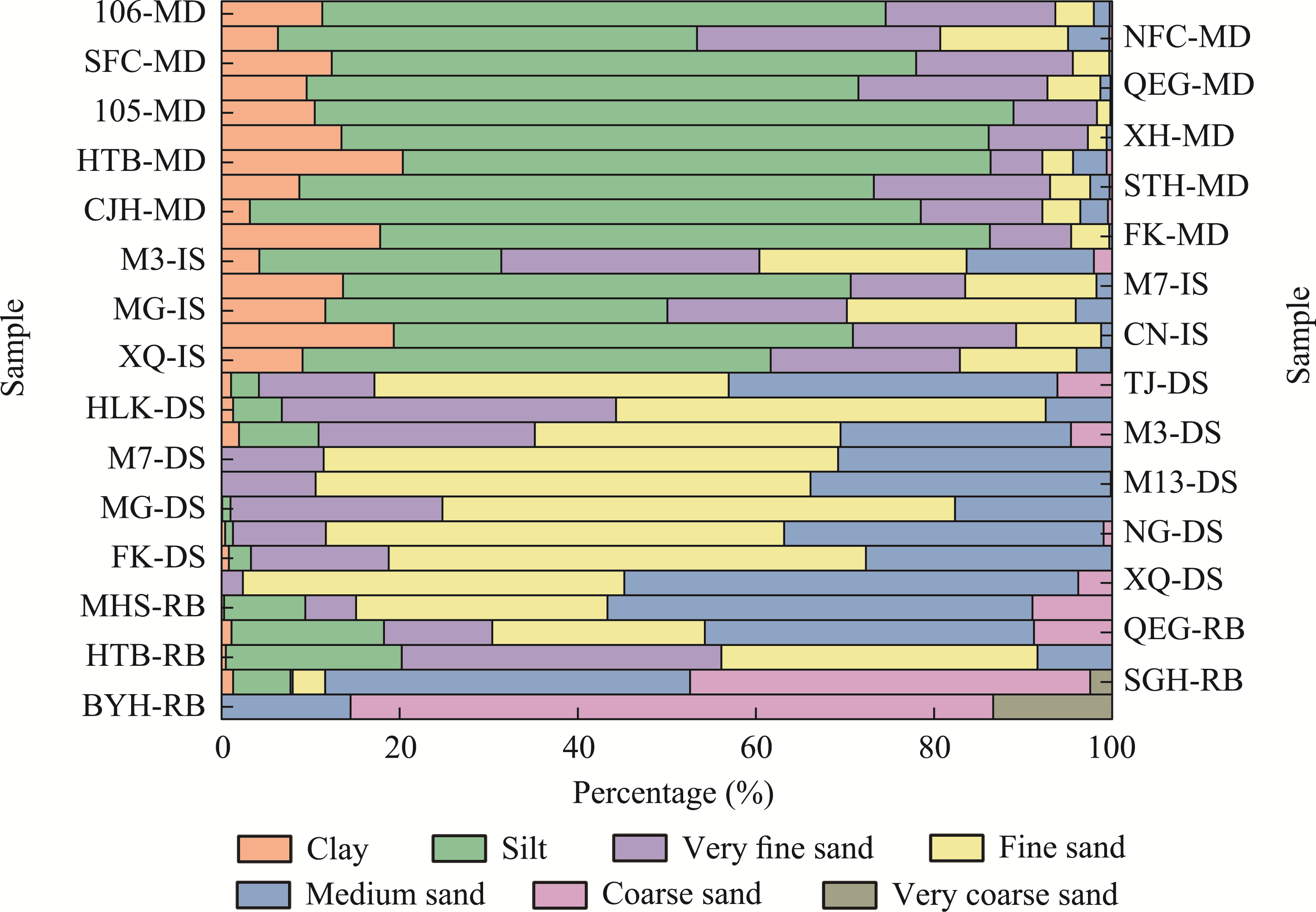
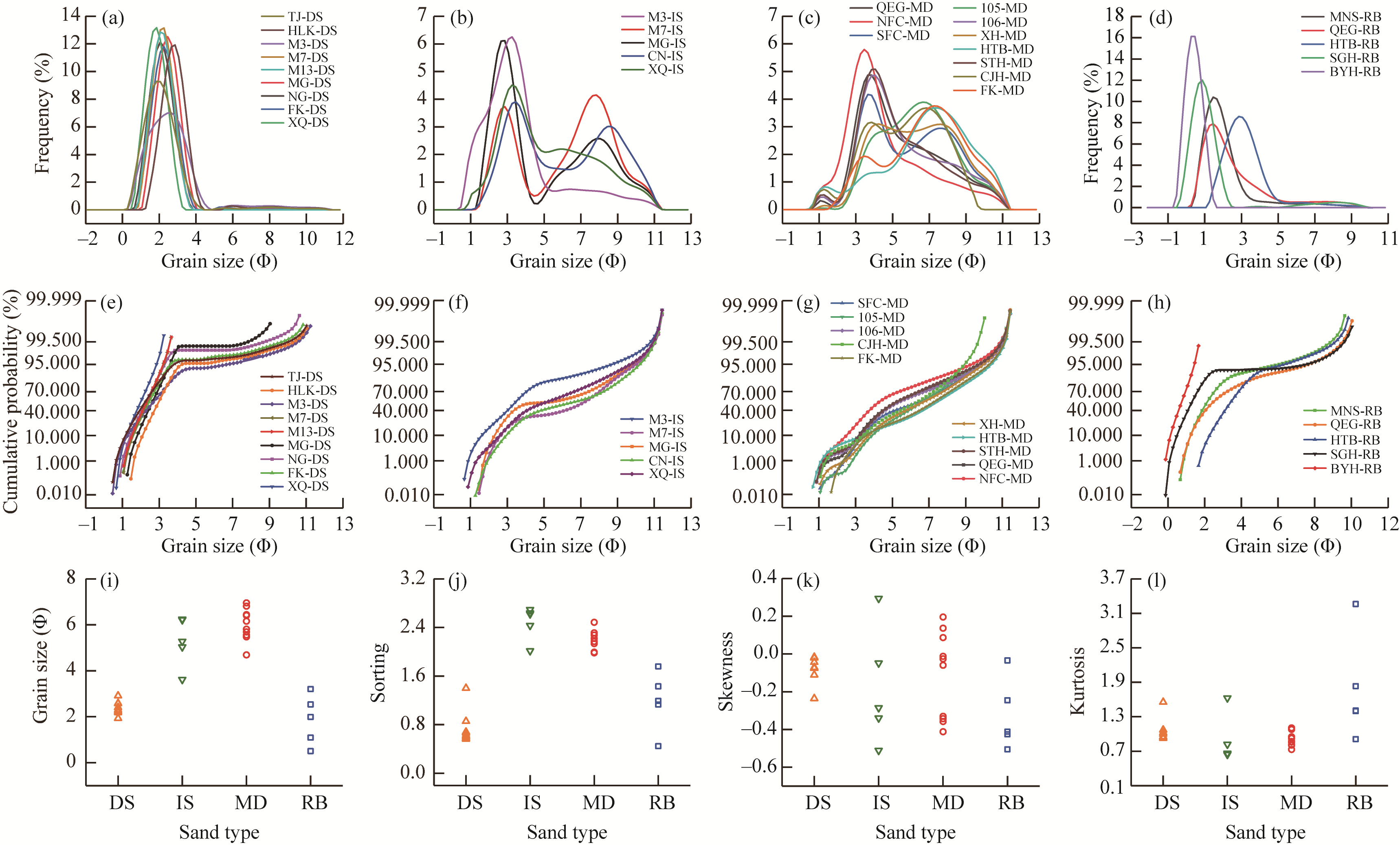
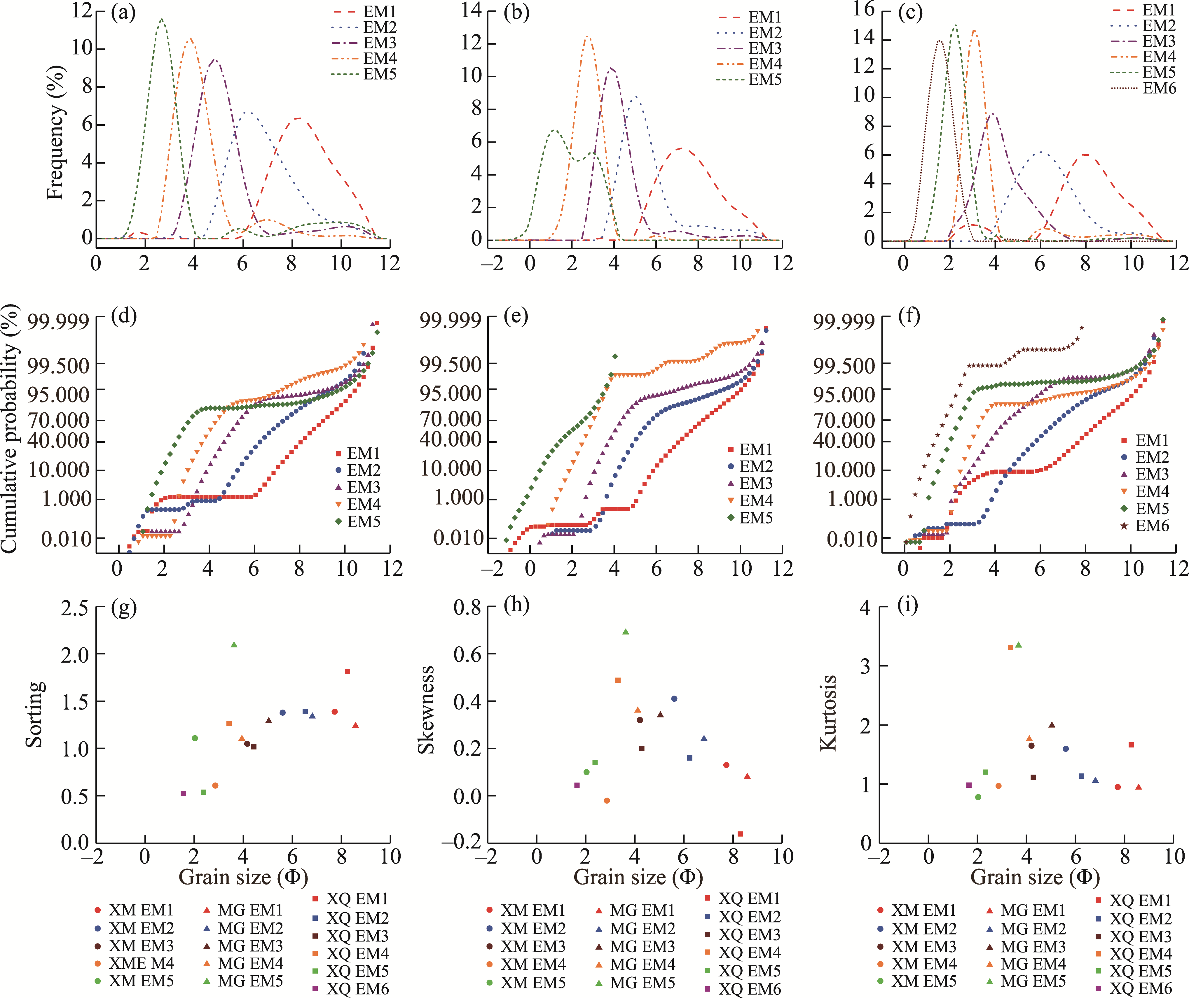
Abstract The southern margin of the Gurbantunggut Desert, China, is characterized by alternating layers of aeolian and alluvial deposits. Investigating the characteristics of arenaceous sediment in this area is of significant importance for understanding the interactive processes of wind and water forces, as well as the provenance of sediment. However, there are relatively few investigations on the characteristics of such sediment at present. In this study, we researched three aeolian-alluvial interactive stratigraphic profiles and different types of surface sediment on the desert-oasis transitional zone of southern margin of the Gurbantunggut Desert. Based on the optically stimulated luminescence (OSL) dating of aeolian sand and analyses of quartz sand grain size and surface micro-texture, we explored the aeolian-alluvial environmental change at southern margin of the desert in Holocene, as well as the provenance of sediment. The results indicated that the grain size characteristics of different types of sediment in the stratigraphic profiles were similar to those of modern dune sand, interdune sand, muddy desert surface soil, and riverbed sand. Their frequency curves were unimodal or bimodal, and cumulative probability curves were two-segment or three-segment, mainly composed of suspension load and saltation load. The quartz sand in the sediment at southern margin of the desert had undergone alternating transformation of various exogenic forces, with short transportation distance and time, and sedimentary environment was relatively humid. In Holocene, southern margin of the desert primarily featured braided river deposits, and during intermittent period of river activity, there were also aeolian deposits such as sand sheet deposits, stabilized dune deposits, and mobile dune deposits. The provenance for Holocene alluvial deposits at southern margin of the desert remains relatively constant, with the debris of the Tianshan Mountains being the primary provenance. Aeolian sand is mainly near-source recharge, which is formed by in situ deposition of fluvial or lacustrine materials in southern margin of the desert transported by wind erosion, and its provenance was still the weathered debris of the Tianshan Mountains. In addition, the sand in interior of the desert may be transported by northwest wind in desert-scale, thus affecting the development of dunes in southern margin of the desert. The results of this study provide a reference for understanding the composition and provenance changes of desert sand in the context of global climate change.
|
|
Received: 18 November 2023
Published: 31 May 2024
|
|
Corresponding Authors:
*LI Zhizhong (E-mail: lizz@fjnu.edu.cn)
|
|
|
| [1] |
Aitken M J. 1998. An Introduction to Optical Dating. Oxford: Oxford University Press.
|
|
|
| [2] |
Chen X. 2010. Natural Geography of Arid Areas in China. Beijing: Science Press. (in Chinese)
|
|
|
| [3] |
Chen Z P. 1963. Basic Features of Gurbantunggut Desert in Junggar Basin. Beijing: Science Press. (in Chinese)
|
|
|
| [4] |
Dai F N. 1988. The relationship between sedimentary environments and features of surface textures of quartz sand in sand dunes of desert area in northern China. Journal of Arid Land Resources and Environment, 2(2): 25-35. (in Chinese)
|
|
|
| [5] |
Folk R L, Ward W C. 1957. Brazos river bar: A study in the significance of grain size parameters. Journal of Sedimentary Research, 27(1): 3-26.
|
|
|
| [6] |
Gao C H, Mu G J, Yan S, et al. 1995. Features of surface micro-textures of quartz sand grains in the hinterland of the Taklimakan Desert and their environmental significance. Geological Review, 41(2): 152-158. (in Chinese)
|
|
|
| [7] |
Gao C, Dong Z B, Nan W G, et al. 2022a. Physicochemical characteristics and sedimentary environment of honeycomb dunes in Gurbantunggut Desert. Journal of Desert Research, 42(2): 14-24. (in Chinese)
|
|
|
| [8] |
Gao W T, Wang B, Peng J, et al. 2022b. Spatial distribution of granularity parameter and provenance indication of aeolian deposits on the southern margin of Tengger Desert. Research of Soil and Water Conservation, 29(6): 129-137. (in Chinese)
|
|
|
| [9] |
Garzanti E, Pastore G, Stone A, et al. 2022. Provenance of Kalahari Sand: Paleoweathering and recycling in a linked fluvial-aeolian system. Earth Science Reviews, 224: 103867, doi: 10.1016/j.earscirev.2021.103867.
|
|
|
| [10] |
Goudie A S. 2002. Great Warm Deserts of the World:Landscapes and Evolution. Oxford: Oxford University Press.
|
|
|
| [11] |
Goudie A S, Middleton N J. 2006. Desert Dust in the Global System. Heidelberg: Springer.
|
|
|
| [12] |
Han Z L, Jianatayi D, Yao Z Q, et al. 2023. Analysis of sedimentary characteristics of braided river to meandering river: Taking Toutunhe formation on the eastern margin of Fukang Sag as an example. Fault-Block Oil & Gas Field, 30(3): 434-440. (in Chinese)
|
|
|
| [13] |
Huang Q. 1996. Environmental changes in the Gurbantunggut Desert since the Late Pleistocene. MSc Thesis. Urumqi: Xinjiang Institute of Ecology and Geography, Chinese Academy of Sciences. (in Chinese)
|
|
|
| [14] |
Huang Q, Zhou X J. 2000. The climate environment changes in the south of Gurbantunggut Desert since 80 ka BP. Arid Land Geography, 23(1): 55-60. (in Chinese)
|
|
|
| [15] |
Huang Y Z, Chen X L, Cheng L Q, et al. 2018. REE characteristics and its provenance implication of surface sediments in the Junggar Basin. Quaternary Sciences, 38(6): 1325-1335. (in Chinese)
|
|
|
| [16] |
Jerolmack D, Reitz M, Martin R. 2011. Sorting out abrasion in a gypsum dune field. Journal of Geophysical Research, 116(2): 1-15.
|
|
|
| [17] |
Jin J, Liu D W, Ji Y L, et al. 2019. Research on lithofacies types, cause mechanisms and distribution of a gravel braided river alluvial fan: A case study of the modern Poplar River alluvial fan, northwestern Junggar Basin. Acta Sedimentologica Sinica, 37(2): 254-267. (in Chinese)
|
|
|
| [18] |
Kang D G, Dai F N. 1988. Features of quartz grains surface textures in the Keriya River, Taklimakan Desert. Journal of Desert Research, 8(4): 46-51. (in Chinese)
|
|
|
| [19] |
Krinsley D H, Doornkamp J C. 1973. Atlas of Quartz Sand Surface Textures. Cambridge: Cambridge University Press.
|
|
|
| [20] |
Lai Z P, Ou X J. 2013. Basic procedures of optically stimulated luminescence (OSL) dating. Progress of Geography, 32(5): 683-693. (in Chinese)
|
|
|
| [21] |
Lancaster N. 1995. Geomorphology of Desert Dunes. Cambridge: Cambridge University Press.
|
|
|
| [22] |
Lee D B, Ferdowsi B, Jerolmack D J. 2019. The imprint of vegetation on desert dune dynamics. Geophysical Research Letters, 46(21): 12041-12048.
doi: 10.1029/2019GL084177
|
|
|
| [23] |
Li B F, Feng Q, Li Z J, et al. 2024. Provenance of surface dune sands in the Gurbantunggut Desert, northwestern China: Qualitative and quantitative assessment using geochemical fingerprinting. Geomorphology, 452: 109115, doi: 10.1016/j.geomorph.2024.109115.
|
|
|
| [24] |
Li J Y, Qu X, Dong Z B, et al. 2021. Contribution of underlying terrain to sand dunes: Evidence from the Qaidam Basin, Northwest China. Journal of Arid Land, 13(12): 1215-1229.
doi: 10.1007/s40333-021-0028-y
|
|
|
| [25] |
Li S F, Yan S, Kong Z C, et al. 2005. Diatom records and environmental changes of the Dongdaohaizi area in Urumqi, Xinjiang. Arid Land Geography, 28(1): 81-87. (in Chinese)
|
|
|
| [26] |
Li S H, Fan A C. 2011. OSL chronology of sand deposits and climate change of last 18 ka in Gurbantunggut Desert, Northwest China. Journal of Quaternary Science, 26(8): 813-818.
|
|
|
| [27] |
Li X M, Yan P, Liu B L. 2020. Geomorphological classification of aeolian-fluvial interactions in the desert region of north China. Journal of Arid Environments, 172: 104021, doi: 10.1016/j.jaridenv.2019.104021.
|
|
|
| [28] |
Liu D W, Ji Y L, Gao C L, et al. 2018. Microfacies and sedimentary models of gravelly braided river alluvial fan: A case study of modern Baiyanghe river alluvial fan in northwestern margin of Junggar Basin. Journal of Paleogeography, 20(3): 435-451. (in Chinese)
|
|
|
| [29] |
Liu Z Y. 2022. Sandy landform and development environment of Gurbantunggut Desert. PhD Dissertation. Xi'an: Shaanxi Normal University, 26-28. (in Chinese)
|
|
|
| [30] |
Ma N N, Mu G J, Yan S. 2005. Discussion and analysis on sediment source of Dongdaohaizi B section in Urumqi since middle Holocene. Arid Land Geography, 28(2): 188-193. (in Chinese)
|
|
|
| [31] |
Murray A S, Wintle A G. 2000. Luminescence dating of quartz using an improved single-aliquot regenerative-dose protocol. Radiation Measurements, 32(1): 57-73.
|
|
|
| [32] |
Parsons A J, Abrahams A D. 2009. Geomorphology of Desert Environments. Dordrecht: Springer.
|
|
|
| [33] |
Paterson G A, Heslop D. 2015. New methods for unmixing sediment grain size date. Geochemistry, Geophysics, Geosystems, 16(2): 4494-4506.
|
|
|
| [34] |
Powers M C. 1953. A new roundness scale for sedimentary particles. Journal of Sedimentary Petrology, 23(2): 117-119.
|
|
|
| [35] |
Prescott J R, Hutton J T. 1994. Cosmic ray contributions to dose rates for luminescence and ESR dating: Large depths and long-term time variations. Radiation Measurements, 23(2-3): 497-500.
|
|
|
| [36] |
Pye K. 1987. Aeolian Dust and Dust Deposits. London: Academic Press.
|
|
|
| [37] |
Pye K, Tsoar H. 2009. Aeolian Sand and Sand Dunes. Berlin: Springer.
|
|
|
| [38] |
Qian Y B, Zhou X J, Wu Z N. 2000. Study on the grain size's characteristics of the sand materials in the Junggar Basin. Arid Zone Research, 17(2): 34-41. (in Chinese)
|
|
|
| [39] |
Qian Y B, Zhou X J, Li C S, et al. 2001. Multi-sources of sand minerals for the desert in the Junggar Basin. Journal of Desert Research, 21(2): 182-187. (in Chinese)
|
|
|
| [40] |
Qian Y B, Zhou X J, Wu Z N, et al. 2003. Multi-sources of desert sands for the Jungger Basin. Journal of Arid Environments, 53(2): 241-256.
|
|
|
| [41] |
Qian Y B, Wu Z N. 2010. Environments of Gurbantunggut Desert. Beijing: Science Press. (in Chinese)
|
|
|
| [42] |
Ren M D, Wang N L. 1981. Generality to Modern Sedimentary Environments. Beijing: Science Press. (in Chinese)
|
|
|
| [43] |
Robins L, Greenbaum N, Yu L P, et al. 2021. High-resolution portable OSL analysis of vegetated linear dune construction in the margins of the northwestern Negev dunefield (Israel) during the Late Quaternary. Aeolian Research, 50: 100680, doi: 10.1016/j.aeolia.2021.100680.
|
|
|
| [44] |
Shi X M, Li Y L, Yang J C. 2007. Environmental significance and clay mineral characteristics of Mogu Lake sediment of Manas River. Arid Land Geography, 30(1): 84-88. (in Chinese)
|
|
|
| [45] |
Shi X M, Xu S N. 2007. Environmental significance and characteristics of sands of Manas River lacustrine plain. Research of Soil and Water Conservation, 14(6): 157-159. (in Chinese)
|
|
|
| [46] |
Shi Z T, Song Y G, An Z S. 2006. Evolution of Gurbantunggut Desert recorded by Tianshan Loess. Journal of Desert Research, 26(5): 675-679. (in Chinese)
|
|
|
| [47] |
Stokes S, Bailey R M, Fedoroff N, et al. 2004. Optical dating of aeolian dynamism on the west African Sahelian margin. Geomorphology, 59(1-4): 281-291.
|
|
|
| [48] |
Sun D H, An Z S, Su R X, et al. 2001. Mathematical method for separation of grain size components of sediments in paleoenvironment and its application. Progress in Natural Science, 11(3): 269-276. (in Chinese)
|
|
|
| [49] |
Tan C P, Yu X H, Li S L, et al. 2014. Discussion on the model of braided river transform to meandering river: As an example of Toutunhe formation in southern Junggar Basin. Acta Sedimentologica Sinica, 32(3): 450-458. (in Chinese)
|
|
|
| [50] |
Tan D J, Ma Y Q, Li Z Z, et al. 2023. Environmental evolution of middle-late Holocene verified by sedimentary evidences in the alluvial plain in the northern foothills of the Tianshan Mountains, China. Mountain Research, 41(3): 307-321. (in Chinese)
|
|
|
| [51] |
Team Northern Shannxi of Chengdu Institute of Geology (TNSCIG). 1978. Grain Size Analysis of Sedimentary Rocks and Its Application. Beijing: Science Press. (in Chinese)
|
|
|
| [52] |
Tursun D, Zhang F, Wu F, et al. 2022. Geochemical characterization of major elements in Gurbantunggut Desert sediments, northwestern China and their regional variations. Aeolian Research, 57: 100802, doi: 10.1016/j.aeolia.2022.100802.
|
|
|
| [53] |
Vos K, Vandenberghe N, Elsen J. 2014. Surface textural analysis of quartz grains by scanning electron microscopy (SEM): From sample preparation to environmental interpretation. Earth Science Reviews, 128: 93-104.
|
|
|
| [54] |
Wang X L, Lu Y C, Li X N. 2005. Luminescence dating of fine- grained quartz in Chinese loess-simplified multiple aliquot regenerative-dose (MAR) protocol. Seismology Geology, 27(4): 615-622. (in Chinese)
|
|
|
| [55] |
Wintle A G, Murray A S. 2006. A review of quartz optically stimulated luminescence characteristics and their relevance in single-aliquot regeneration dating protocols. Radiation Measurements, 41(4): 369-391.
|
|
|
| [56] |
Wu J L, Wang S M, Wang H D. 1996. Characters of the evolution of climate and environment of Holocene in Aibi Lake Basin in Xinjiang. Oceanologia et Limnologia Sinica, 27(5): 524-530. (in Chinese)
|
|
|
| [57] |
Wu J L, Shen J, Wang S M, et al. 2003. Characteristics of early Holocene climate and environment recorded by lake sediments in Ebinur Lake area, Xinjiang. Science China Earth Sciences, 33(6): 569-575. (in Chinese)
|
|
|
| [58] |
Wu Z. 1962. The Basic Characteristics of Desert Landform Development in Junggar Basin. Beijing: Science Press. (in Chinese)
|
|
|
| [59] |
Wu Z. 1995. A comparative study of the surface texture of quartz sand in inland deserts than in coastal dunes, China. Journal of Desert Research, 15(3): 201-206. (in Chinese)
|
|
|
| [60] |
Wu Z. 2009. Chinese Desert and Its Governance. Beijing: Science Press. (in Chinese)
|
|
|
| [61] |
Xinjiang Expedition of Chinese Academy of Sciences (XECAS). 1978. Xinjiang Landform. Beijing: Science Press. (in Chinese)
|
|
|
| [62] |
Yan S, Li S F, Kong Z C, et al. 2004. The pollen analyses and environment changes of the Dongdaohaizi area in Urumqi, Xinjiang. Quaternary Sciences, 24(4): 463-468. (in Chinese)
|
|
|
| [63] |
Yang X P, Karl T R, Frank L, et al. 2004. The evolution of dry lands in northern China and in the Republic of Mongolia since the Last Glacial Maximum. Quaternary International, 118-119: 69-85.
|
|
|
| [64] |
Yang X P, Li H W, Conacher A. 2012. Large-scale controls on the development of sand seas in northern China. Quaternary International, 250: 74-83.
|
|
|
| [65] |
Yang X P, Eitel B. 2016. Understanding the interactions between climate change, landscape evolution, surface processes and tectonics in the Earth system: What can the studies of Chinese deserts contribute? Acta Geologica Sinica, 90(4): 1444-1454.
|
|
|
| [66] |
Yang X P, Du J H, Liang P, et al. 2021. Paleoenvironmental changes in the central part of the Taklamakan Desert, northwestern China since the late Pleistocene. Chinese Science Bulletin, 66(24): 3205-3218.
|
|
|
| [67] |
Yin H Z. 1978. The relationship between the tectonics and geomorphology in the Junggar Basin. Arid Land Geography, 10(4): 13-21. (in Chinese)
|
|
|
| [68] |
Zhang F, Xia Q Q, Dilibaier T, et al. 2021. Holocene hydrology and environment changes in the Keriya River Delta in 13.8-2.3 ka in Taklimakan Desert: Inferred from the stratigraphy. Arid Land Geography, 44(1): 178-187. (in Chinese)
|
|
|
| [69] |
Zhang Z C, Liang A M, Dong Z B, et al. 2022. Sand provenance in the Gurbantunggut Desert, northern China. Catena, 214: 106242, doi: 10.1016/j.catena.2022.106242.
|
|
|
| [70] |
Zhao J. 2020. Study on the characteristics of aeolian sediments in Gurbantunggut Desert. MSc Thesis. Xi'an: Shaanxi Normal University. (in Chinese)
|
|
|
| [71] |
Zhu B Q, Yu J J, Qin X G, et al. 2014. Formation and evolution of sand desert in Xinjiang, Northwest China: Provenance of desert sands. Journal of Geographical Sciences, 24(1): 177-190.
|
|
|
| [72] |
Zhu C M, Dong Z B, Liu Z Y, et al. 2021. Grain size and micro-morphology characteristics of the surface sediments of dendritic sand dunes in the Gurbantunggut Desert. Journal of Desert Research, 41(2): 9-18. (in Chinese)
|
|
|
| [73] |
Zhu Z D, Wu Z, Liu S. 1980. Generality to Chinese Desert. Beijing: Science Press. (in Chinese)
|
|
|
| [74] |
Zong H R, Fu X, Li Z J, et al. 2022. Multi-method pIRIR dating of sedimentary sequences at the southern edge of the Gurbantunggut Desert, NW China and its paleoenvironmental implications. Quaternary Geochronology, 70: 101300, doi: 10.1016/j.quageo.2022.101300.
|
|
|
|
Viewed |
|
|
|
Full text
|
|
|
|
|
Abstract
|
|
|
|
|
Cited |
|
|
|
|
| |
Shared |
|
|
|
|
| |
Discussed |
|
|
|
|