| Research article |
|


|
|
|
| Environmental interpretation of spatial heterogeneity in the trade-offs and synergies of land use functions: A study based on the XGBoost-SHAP model |
FENG Haoyuan1,2, ZHANG Xuebin1,*( ), SHI Peiji1, SHI Jing3, WANG Ziyang1 ), SHI Peiji1, SHI Jing3, WANG Ziyang1 |
1College of Geography and Environmental Sciences, Northwest Normal University, Lanzhou 730070, China
2Engineering Research Center for Ecological and Environmental Damage Assessment of Gansu Province, Northwest Normal University, Lanzhou 730070, China
3College of Ecology, Lanzhou University, Lanzhou 730000, China |
|
|
|
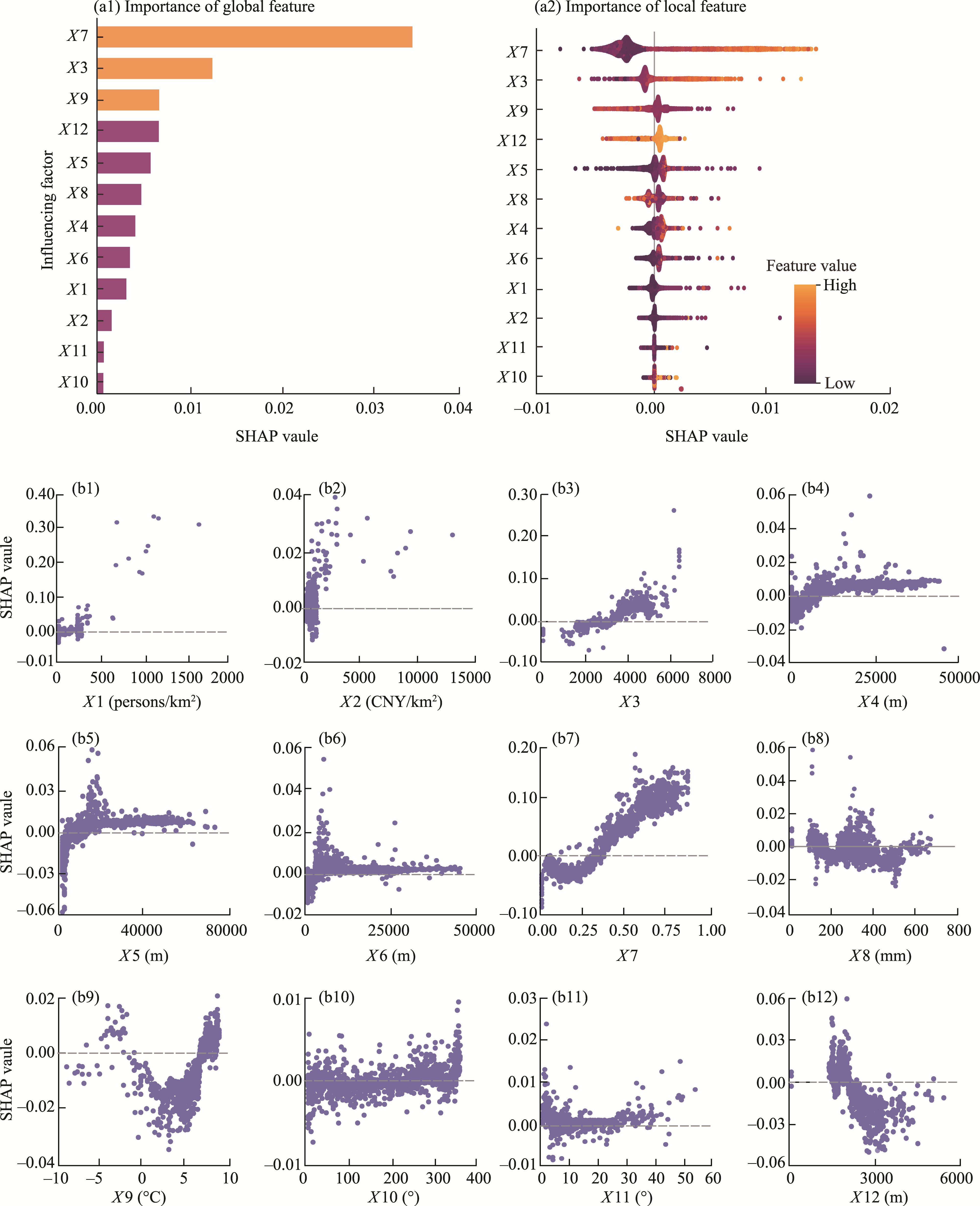
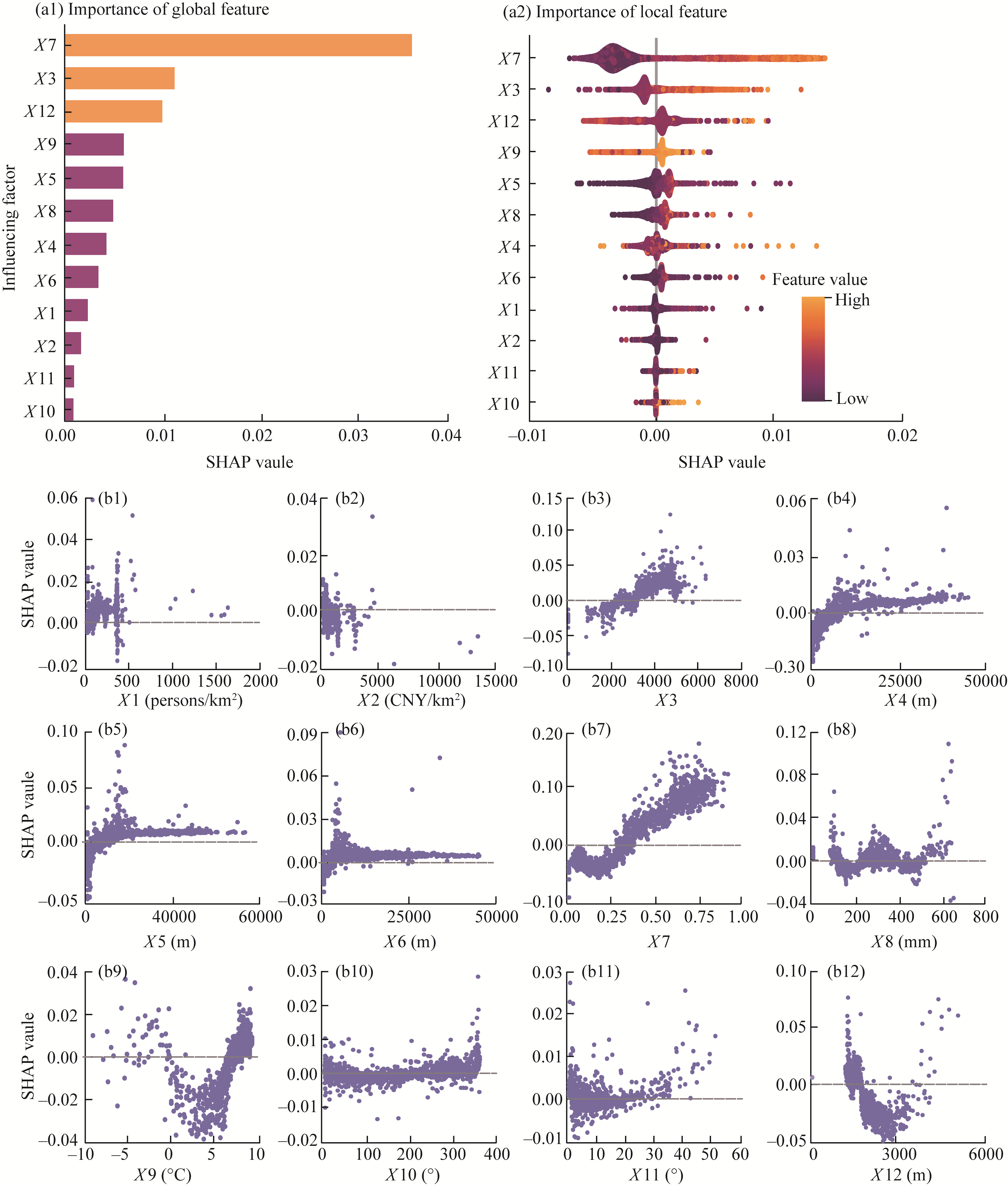
Abstract Accurately revealing the spatial heterogeneity in the trade-offs and synergies of land use functions (LUFs) and their driving factors is imperative for advancing sustainable land utilization and optimizing land use planning. This is especially critical for ecologically vulnerable inland river basins in arid regions. However, existing methods struggle to effectively capture complex nonlinear interactions among environmental factors and their multifaceted relationships with trade-offs and synergies of LUFs, especially for the inland river basins in arid regions. Consequently, this study focused on the middle reaches of the Heihe River Basin (MHRB), an arid inland river basin in northwestern China. Using land use, socioeconomic, meteorological, and hydrological data from 2000 to 2020, we analyzed the spatiotemporal patterns of LUFs and their trade-off and synergy relationships from the perspective of production, living, ecological functions. Additionally, we employed an integrated Extreme Gradient Boosting (XGBoost)-SHapley Additive exPlanations (SHAP) framework to investigate the environmental factors influencing the spatial heterogeneity in the trade-offs and synergies of LUFs. Our findings reveal that from 2000 to 2020, the production, living, and ecological functions of land use within the MHRB exhibited an increasing trend, demonstrating a distinct spatial pattern of ''high in the southwest and low in the northeast''. Significant spatial heterogeneity defined the trade-off and synergistic relationships, with trade-offs dominating human activity-intensive oasis areas, while synergies prevailed in other areas. During the study period, synergistic relationships between production and living functions and between production and ecological functions were relatively robust, whereas synergies in living-ecological functions remained weaker. Natural factors (digital elevation model (DEM), annual mean temperature, Normalized Difference Vegetation Index (NDVI), and annual precipitation) emerged as the primary factors driving the trade-offs and synergies of LUFs, followed by socioeconomic factors (population density, Gross Domestic Product (GDP), and land use intensity), while distance factors (distance to water bodies, distance to residential areas, and distance to roads) exerted minimal influence. Notably, the interactions among NDVI, annual mean temperature, DEM, and land use intensity exerted the most substantial impacts on the relationships among LUFs. This study provides novel perspectives and methodologies for unraveling the mechanisms underlying the spatial heterogeneity in the trade-offs and synergies of LUFs, offering scientific insights to inform regional land use planning and sustainable natural resource management in inland river basins in arid regions.
|
|
Received: 25 April 2025
Published: 31 October 2025
|
|
Corresponding Authors:
*ZHANG Xuebin (Email: zhangxb@nwnu.edu.cn)
|
|
|
| [1] |
Alam S A, Starr M, Clark B J F. 2013. Tree biomass and soil organic carbon densities across the Sudanese woodland savannah: A regional carbon sequestration study. Journal of Arid Environments, 89: 67-76.
|
|
|
| [2] |
Bahr S. 2024. The relationship between urban greenery, mixed land use and life satisfaction: An examination using remote sensing data and deep learning. Landscape and Urban Planning, 251: 105174, doi: 10.1016/j.landurbplan.2024.105174.
|
|
|
| [3] |
Bai M, Li Z L, Huo P Y, et al. 2023. Propagation characteristics from meteorological drought to agricultural drought over the Heihe River Basin, Northwest China. Journal of Arid Land, 15(5): 523-544.
doi: 10.1007/s40333-023-0059-7
|
|
|
| [4] |
Boulot E. 2025. The environmental statehood of ecological restoration: An institutional analysis of three regulatory case studies. Global Environmental Change, 91: 102982, doi: 10.1016/j.gloenvcha.2025.102982.
|
|
|
| [5] |
Bureau of Statistics of Gansu Province. 2001-2021a. Gansu Rural Yearbook. Beijing: China Statistics Press. (in Chinese)
|
|
|
| [6] |
Bureau of Statistics of Gansu Province. 2001-2021b. Gansu Statistical Yearbook. Beijing: China Statistics Press. (in Chinese)
|
|
|
| [7] |
Bureau of Statistics of Zhangye City. 2001-2021. Zhangye Statistical Bulletin of National Economic and Social Development. [2025-02-09]. https://www.zhangye.gov.cn/sjfb/tjgb/ghb.html. (in Chinese)
|
|
|
| [8] |
Chen F, Leung Y, Wang Q, et al. 2024. Spatial non-stationarity test of regression relationships in the multiscale geographically weighted regression model. Spatial Statistics, 62: 100846, doi: 10.1016/j.spasta.2024.100846.
|
|
|
| [9] |
Chen F X, Li Y R, Liu Y S. 2025. Spatial-temporal evolution and coupling coordination of land use functions across China by fusing multiple-source heterogeneous data. Land Use Policy, 155: 107590, doi: 10.1016/j.landusepol.2025.107590.
|
|
|
| [10] |
Department of Water Resources of Gansu Province. 2001-2021. Gansu Provincial Water Resources Bulletin. [2025-02-09]. https://slt.gansu.gov.cn/slt/c106726/c106732/c106773/zcfg.shtml. (in Chinese)
|
|
|
| [11] |
Geng Y W, Li X S, Chen J Q. 2025. Integration of land use resilience and efficiency in China: Analysis of spatial patterns, differential impacts on SDGs, and adaptive management strategies. Applied Geography, 175: 103490, doi: 10.1016/j.apgeog.2024.103490.
|
|
|
| [12] |
Hanacek K, Rodriguez-Labajos B. 2018. Impacts of land-use and management changes on cultural agroecosystem services and environmental conflicts-A global review. Global Environmental Change, 50: 41-59.
|
|
|
| [13] |
He H X, Yan J N, Liang D, et al. 2024. Time-series land cover change detection using deep learning-based temporal semantic segmentation. Remote Sensing of Environment, 305: 114101, doi: 10.1016/j.rse.2024.114101.
|
|
|
| [14] |
Huang F J, Tang J Q, Lin H L, et al. 2023a. Built environment effects on the spatio-temporal distribution of shared bikes based on multi-scale geographic weighted regression. Geographical Research, 42(9): 2405-2418. (in Chinese)
|
|
|
| [15] |
Huang F X, Zuo L Y, Gao J B, et al. 2023b. Exploring the driving factors of trade-offs and synergies among ecological functional zones based on ecosystem service bundles. Ecological Indicators, 146: 109827, doi: 10.1016/j.ecolind.2022.109827.
|
|
|
| [16] |
Jafary P, Shojaei D, Rajabifard A, et al. 2024. Automated land valuation models: A comparative study of four machine learning and deep learning methods based on a comprehensive range of influential factors. Cities, 151: 105115, doi: 10.1016/j.cities.2024.105115.
|
|
|
| [17] |
Jiang S, Meng J J, Zhu L K. 2020. Spatial and temporal analyses of potential land use conflict under the constraints of water resources in the middle reaches of the Heihe River. Land Use Policy, 97: 104773, doi: 10.1016/j.landusepol.2020.104773.
|
|
|
| [18] |
Kassun B W, Kallio M, Trømborg E, et al. 2025. Land use and land cover change, trade-offs, and synergies between ecosystem services in a dry Afromontane Forest. Journal for Nature Conservation, 85: 126874, doi: 10.1016/j.jnc.2025.126874.
|
|
|
| [19] |
Ke L, Lei N, Zhang S L, et al. 2025. Estimation of blue carbon stock in the Liaohe Estuary wetland based on soil thickness and multi-scenario modeling. Ecological Indicators, 171: 113201, doi: 10.1016/j.ecolind.2025.113201.
|
|
|
| [20] |
Khan F, Abbass K, Qun W, et al. 2025. Moderating role of digital media on environmental awareness and environmental beliefs to shape farmers' behavioral intentions towards sustainable agricultural land conservation practices. Journal of Environmental Management, 373: 123845, doi: 10.1016/j.jenvman.2024.123745.
|
|
|
| [21] |
Li K, Zhao J S, Li Y P, et al. 2025. Identifying trade-offs and synergies among land use functions using an XGBoost-SHAP model: A case study of Kunming, China. Ecological Indicators, 172: 113330, doi: 10.1016/j.ecolind.2025.113330.
|
|
|
| [22] |
Li Q R, Jia Y L, Wang H J, et al. 2023a. Analysis of trade-off and synergy effects of ecosystem services in Hebei Province from the perspective of ecological function area. Acta Geographica Sinica, 78(11): 2833-2849. (in Chinese)
|
|
|
| [23] |
Li S N, An W Z, Zhang J, et al. 2023b. Optimizing limit lines in urban-rural transitional areas: Unveiling the spatial dynamics of trade-offs and synergies among land use functions. Habitat International, 140: 102907, doi: 10.1016/j.habitatint.2023.102907.
|
|
|
| [24] |
Li X, Lu L, Cheng G, et al. 2001. Quantifying landscape structure of the Heihe River Basin, North-west China using FRAGSTATS. Journal of Arid Environments, 48(4): 521-535.
|
|
|
| [25] |
Liu J M, Pei X T, Zhu W Y, et al. 2024. Water-related ecosystem services interactions and their natural-human activity drivers: Implications for ecological protection and restoration. Journal of Environmental Management, 352: 120101, doi: 10.1016/j.jenvman.2024.120101.
|
|
|
| [26] |
National Bureau of Statistics. 2001-2021. China Statistical Yearbook. Beijing: China Statistics Press. (in Chinese)
|
|
|
| [27] |
Nie H R, Zhao Y, Zhu J, et al. 2024. Ecological security pattern construction in typical oasis area based on ant colony optimization: A case study in Yili River Valley, China. Ecological Indicators, 169: 112770, doi: 10.1016/j.ecolind.2024.112770.
|
|
|
| [28] |
Peng Y Z, Yu G I. 2024. Model multifactor analysis of soil heavy metal pollution on plant germination in Southeast Chengdu, China: Based on redundancy analysis, factor detector, and XGBoost-SHAP. Science of the Total Environment, 954: 176605, doi: 10.1016/j.scitotenv.2024.176605.
|
|
|
| [29] |
Qiao W F, Li C, Dai L L, et al. 2024. Progress and prospects in the study of coupling rural multifunctional evolution and land use transitions. Geographical Research, 43(6): 1556-1571. (in Chinese)
|
|
|
| [30] |
Qu Y B, Zhan L Y, Wei C C, et al. 2024. Interactive transition of cultivated land and construction land during China's urbanization: A coordinated analytical framework of explicit and implicit forms. Land Use Policy, 138: 107049, doi: 10.1016/j.landusepol.2024.107049.
|
|
|
| [31] |
Rallings A M, Smukler S M, Gergel S E, et al. 2019. Towards multifunctional land use in an agricultural landscape: A trade-off and synergy analysis in the Lower Fraser Valley, Canada. Landscape and Urban Planning, 184: 88-100.
doi: 10.1016/j.landurbplan.2018.12.013
|
|
|
| [32] |
Reith E, Gosling E, Knoke T, et al. 2022. Exploring trade-offs in agro-ecological landscapes: Using a multi-objective land-use allocation model to support agroforestry research. Basic and Applied Ecology, 64: 103-119.
|
|
|
| [33] |
Ren J, Ma R R, Huang Y H, et al. 2024. Identifying the trade-offs and synergies of land use functions and their influencing factors of Lanzhou-Xining urban agglomeration in the upper reaches of Yellow River Basin, China. Ecological Indicators, 158: 111279, doi: 10.1016/j.ecolind.2023.111279.
|
|
|
| [34] |
Shim S H, Choi J H. 2024. Building an XGBoost model based on landscape metrics and meteorological data for nonpoint source pollution management in the Nakdong River watershed. Ecological Indicators, 165: 112156, doi: 10.1016/j.ecolind.2024.112156.
|
|
|
| [35] |
Su Y Q, Feng Q, Liu W, et al. 2023. Improved understanding of trade-offs and synergies in ecosystem services via fine land-use classification and multi-scale analysis in the arid region of Northwest China. Remote Sensing, 15(20): 4976, doi: 10.3390/rs15204976.
|
|
|
| [36] |
Ustaoglu E, Aydınoglu A C. 2019. Regional variations of land-use development and land-use/cover change dynamics: A case study of Turkey. Remote Sensing, 11(7): 885, doi: 10.3390/rs11070885.
|
|
|
| [37] |
Viruel E, Fontana C A, Puglisi E, et al. 2022. Land-use change affects the diversity and functionality of soil bacterial communities in semi-arid Chaco region, Argentina. Applied Soil Ecology, 172: 104362, doi: 10.1016/j.apsoil.2021.104362.
|
|
|
| [38] |
Wang S L, Jin X B, Han B, et al. 2025. Understanding the process and mechanism of agricultural land transition in China: Based on the interactive conversion of cropland and natural ecological land. Journal of Environmental Management, 376: 124585, doi: 10.1016/j.jenvman.2025.124585.
|
|
|
| [39] |
Wang Y F, Cheng L L, Zheng Y, et al. 2024a. Evolution of land use functions and their trade-offs/synergies relationship in resource-based cities. Ecological Indicators, 165: 112175, doi: 10.1016/j.ecolind.2024.112175.
|
|
|
| [40] |
Wang Y X, Ao Y H, Li Z G. 2022. Evapotranspiration characteristics of different oases and effects of human activities on evapotranspiration in Heihe River Basin. Remote Sensing, 14(24): 6283, doi: 10.3390/rs14246283.
|
|
|
| [41] |
Wang Z Y, Shi P J, Li X H, et al. 2024b. Response mechanism and promotion path of habitat quality to land use change in Hexi Corridor area. Environmental Science, 45(12): 6910-6921. (in Chinese)
|
|
|
| [42] |
Wei C, Wu Z, Xing J, et al. 2024. Trade-off or synergy? Dynamic analysis and policy insights on land use functions in China. Environmental Impact Assessment Review, 105: 107399, doi: 10.1016/j.eiar.2023.107399.
|
|
|
| [43] |
Wu D, Zheng L, Wang Y, et al. 2024. Dynamics in construction land patterns and its impact on water-related ecosystem services in Chengdu-Chongqing urban agglomeration, China: A multi-scale study. Journal of Cleaner Production, 469: 143022, doi: 10.1016/j.jclepro.2024.143022.
|
|
|
| [44] |
Wu F, Zhan J Y, Güneralp İ. 2015. Present and future of urban water balance in the rapidly urbanizing Heihe River Basin, Northwest China. Ecological Modelling, 318: 254-264.
|
|
|
| [45] |
Wu Q Q, Meng J J. 2023. Analysis of the evolution and driving factors of production-living-ecological space pattern in the Heihe River Basin from 1980 to 2020, China. Acta Scientiarum Naturalium Universitatis Pekinensis, 59(6): 970-980. (in Chinese)
|
|
|
| [46] |
Xiao X Y, Hu M Y, Li X B, et al. 2018. Analysis on changes of agricultural structure and its driving factors in the middle reaches of Heihe River at plot scale—A case study of Zhangye City. Journal of Natural Resources, 33(3): 386-397. (in Chinese)
|
|
|
| [47] |
Xu A K, Hu M J, Shi J, et al. 2024. Construction and optimization of ecological network in inland river basin based on circuit theory, complex network and ecological sensitivity: A case study of Gansu section of Heihe River Basin. Ecological Modelling, 488: 110578, doi: 10.1016/j.ecolmodel.2023.110578.
|
|
|
| [48] |
Yan Y, Guan Q Y, Shao W Y, et al. 2023. Spatiotemporal dynamics and driving mechanism of arable ecosystem stability in arid and semi-arid areas based on Pressure-Buffer-Response process. Journal of Cleaner Production, 421: 138553, doi: 10.1016/j.jclepro.2023.138553.
|
|
|
| [49] |
Yang D F, Wang X M, Han R N. 2023a. Nonlinear and synergistic effects of the built environment on street vitality: The case of Shenyang. Urban Planning Forum, 5: 93-102. (in Chinese)
|
|
|
| [50] |
Yang H J, Liu Z X, Yin J, et al. 2025. Coordination and driving analysis of 'Production-Living-Ecological' functions of cultivated land in Yunnan Province based on multi-source time series data. Geojournal, 90: 108, doi: 10.1007/s10708-025-11354-0.
|
|
|
| [51] |
Yang Y Y, Ren X Z, Yan J M. 2023b. Trade-offs or synergies? Identifying dynamic land use functions and their interrelations at the grid scale in urban agglomeration. Cities, 140: 104384, doi: 10.1016/j.cities.2023.104384.
|
|
|
| [52] |
Yu S H, Hu X Y, Sheng Y H, et al. 2025. Similarity and geographically weighted regression considering spatial scales of features space. Spatial Statistics, 97: 100897, doi: 10.1016/j.spasta.2025.100897.
|
|
|
| [53] |
Yuan Y Y, Guo W, Tang S Q, et al. 2024. Effects of patterns of urban green-blue landscape on carbon sequestration using XGBoost-SHAP model. Journal of Cleaner Production, 476: 143640, doi: 10.1016/j.jclepro.2024.143640.
|
|
|
| [54] |
Zhang H Z, Tang Q, He X B, et al. 2024. Land use function changes and trade-offs/synergies across topographic gradients in the Three Gorges Reservoir Area, China. Journal of Cleaner Production, 469: 143233, doi: 10.1016/j.jclepro.2024.143233.
|
|
|
| [55] |
Zhang J, Li S N, Lin N F, et al. 2022. Spatial identification and trade-off analysis of land use functions improve spatial zoning management in rapid urbanized areas, China. Land Use Policy, 116: 106058, doi: 10.1016/j.landusepol.2022.106058.
|
|
|
| [56] |
Zhang Z P, Guan Q Y, Zhao B, et al. 2025. Multi-objective optimal allocation of agricultural water and land resources in the Heihe River Basin: Coupling of climate and land use change. Journal of Hydrology, 653: 132783, doi: 10.1016/j.jhydrol.2025.132783.
|
|
|
| [57] |
Zhao D S, Zhu Y, Wu S H, et al. 2022. Simulated response of soil organic carbon density to climate change in the northern Tibet permafrost region. Geoderma, 405: 115455, doi: 10.1016/j.geoderma.2021.115455.
|
|
|
| [58] |
Zheng J T, Wang P, Shi H Y, et al. 2023. Quantitative analysis of the influence factors and extent of soil heavy metals based on CatBoost model and SHAP interpretation method. Acta Scientiae Circumstantiae, 43(4): 448-456. (in Chinese)
|
|
|
| [59] |
Zhong L N, Wang J, Zhang X, et al. 2020. Effects of agricultural land consolidation on ecosystem services: Trade-offs and synergies. Journal of Cleaner Production, 264: 121412, doi: 10.1016/j.jclepro.2020.121412.
|
|
|
| [60] |
Zhou Q, Zhang Y L, Wu F. 2021. Evaluation of the most proper management scale on water use efficiency and water productivity: A case study of the Heihe River Basin, China. Agricultural Water Management, 246: 106671, doi: 10.1016/j.agwat.2020.106671.
|
|
|
| [61] |
Zhu C M, Dong B Y, Li S N, et al. 2021. Identifying the trade-offs and synergies among land use functions and their influencing factors from a geospatial perspective: A case study in Hangzhou, China. Journal of Cleaner Production, 314: 128026, doi: 10.1016/j.jclepro.2021.128026.
|
|
|
| [62] |
Zhu G F, Wang L, Liu Y W, et al. 2022. Snow-melt water: An important water source for Picea crassifolia in Qilian Mountains. Journal of Hydrology, 613: 128441, doi: 10.1016/j.jhydrol.2022.128441.
|
|
|
| [63] |
Zou L L, Liu Y S, Wang J Y, et al. 2021. An analysis of land use conflict potentials based on ecological-production-living function in the southeast coastal area of China. Ecological Indicators, 122: 107297, doi: 10.1016/j.ecolind.2020.107297.
|
|
|
| [64] |
Zou M Z, Deng Y Y, Du T S, et al. 2023. Agricultural transformation towards delivering deep carbon cuts in China's arid inland areas. Environment International, 180: 108245, doi: 10.1016/j.envint.2023.108245.
|
|
|
| [65] |
Zubaida M. 2024. Trade-offs and synergies between ecosystem services in Yutian County along the Keriya River Basin, Northwest China. Journal of Arid Land, 16(7): 943-962.
doi: 10.1007/s40333-024-0103-2
|
|
|
|
Viewed |
|
|
|
Full text
|
|
|
|
|
Abstract
|
|
|
|
|
Cited |
|
|
|
|
| |
Shared |
|
|
|
|
| |
Discussed |
|
|
|
|