| Research article |
|


|
|
|
| Research on wind erosion processes and controlling factors based on wind tunnel test and 3D laser scanning technology |
YAN Ping1,2, WANG Xiaoxu1,3,4,*( ), ZHENG Shucheng1,3, WANG Yong5, LI Xiaomei6 ), ZHENG Shucheng1,3, WANG Yong5, LI Xiaomei6 |
1Faculty of Geographical Science, Beijing Normal University, Beijing 100875, China
2Zhuhai Branch of State Key Laboratory of Earth Surface Processes and Resource Ecology, Beijing Normal University, Zhuhai 519087, China
3State Key Laboratory of Earth Surface Processes and Resource Ecology, Beijing Normal University, Beijing 100875, China
4MOE Engineering Research Centre of Desertification and Blown-sand Control, Beijing 100875, China
5Institute of Geographical Sciences, Henan Academy of Sciences, Zhengzhou 450052, China
6School of Geography and Tourism, Shaanxi Normal University, Xi'an 710119, China |
|
|
|
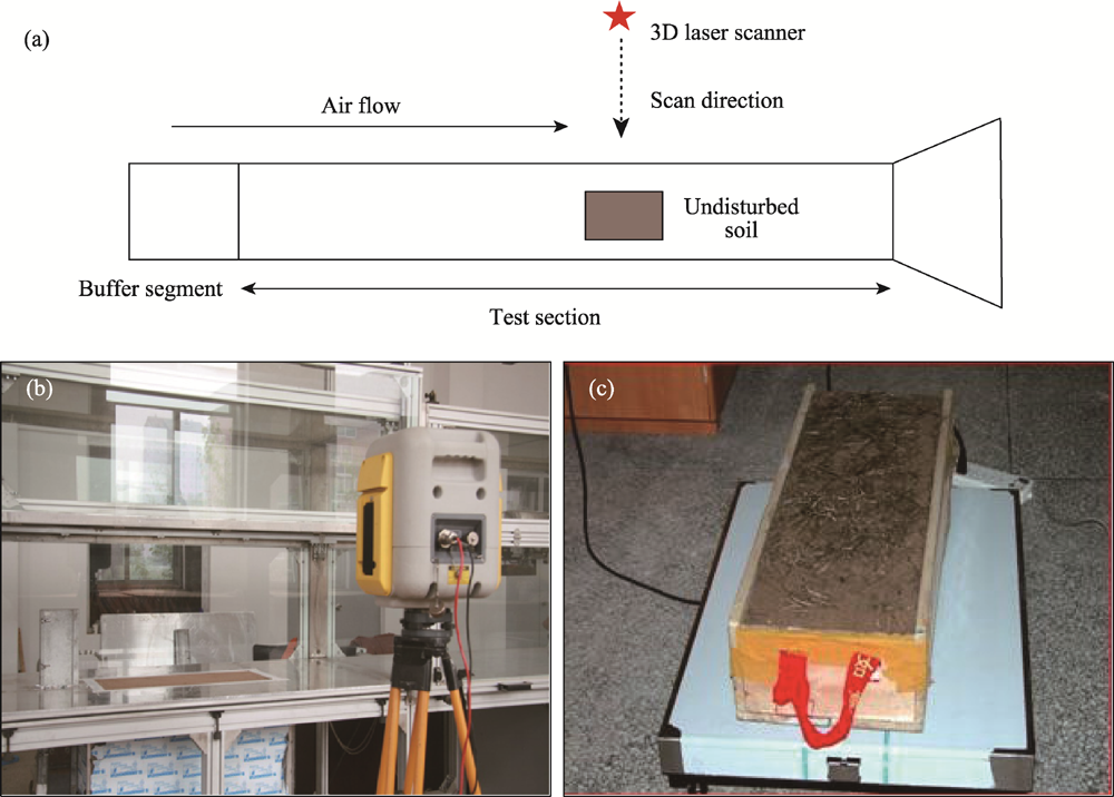
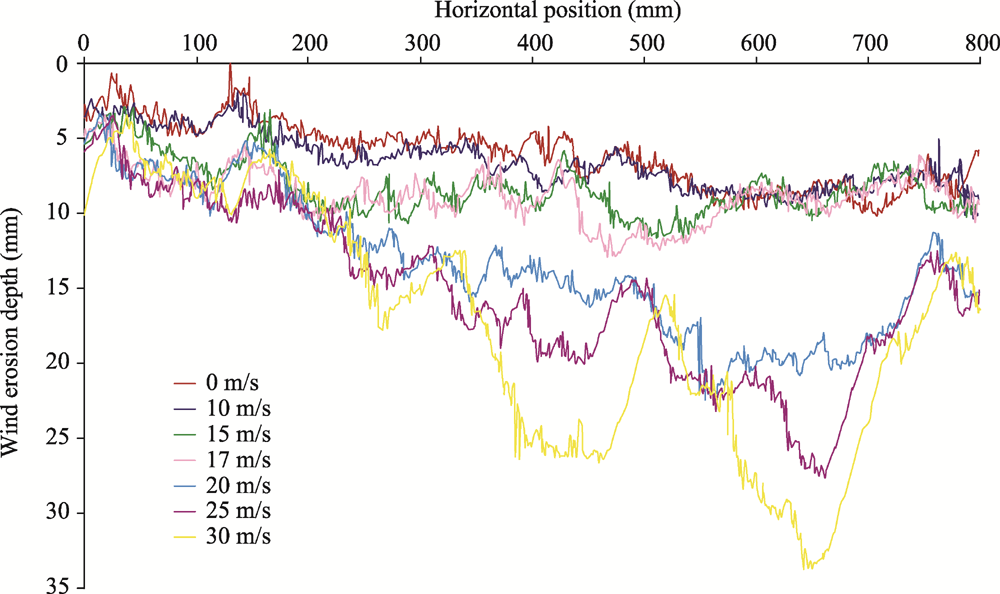
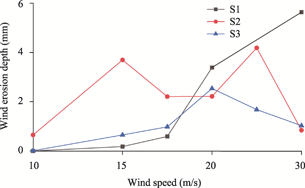
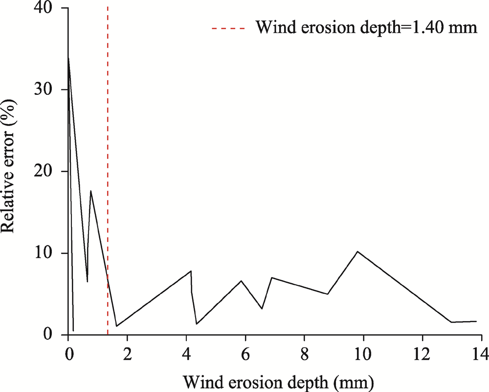
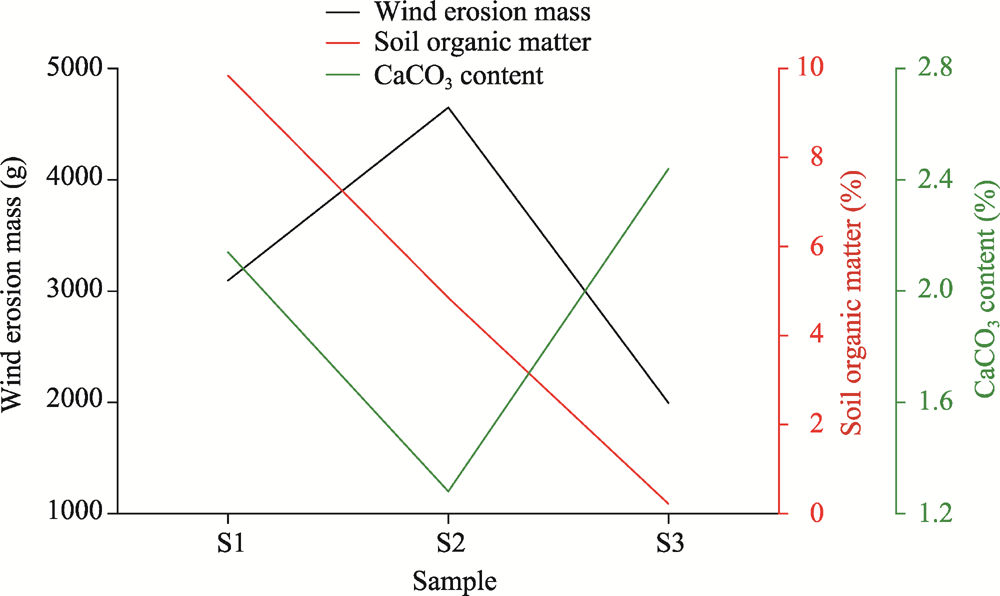
Abstract The study of wind erosion processes is of great importance to the prevention and control of soil wind erosion. In this study, three structurally intact soil samples were collected from the steppe of Inner Mongolia Autonomous Region, China and placed in a wind tunnel where they were subjected to six different wind speeds (10, 15, 17, 20, 25, and 30 m/s) to simulate wind erosion in the wind tunnel. After each test, the soil surfaces were scanned by a 3D laser scanner to create a high-resolution Digital Elevation Model (DEM), and the changes in wind erosion mass and microtopography were quantified. Based on this, we performed further analysis of wind erosion-controlling factors. The study results showed that the average measurement error between the 3D laser scanning method and weighing method was 6.23% for the three undisturbed soil samples. With increasing wind speed, the microtopography on the undisturbed soil surface first became smooth, and then fine stripes and pits gradually developed. In the initial stage of wind erosion processes, the ability of the soil to resist wind erosion was mainly affected by the soil hardness. In the late stage of wind erosion processes, the degree of soil erosion was mainly affected by soil organic matter and CaCO3 content. The results of this study are expected to provide a theoretical basis for soil wind erosion control and promote the application of 3D laser scanners in wind erosion monitoring.
|
|
Received: 13 June 2022
Published: 30 September 2022
|
|
Corresponding Authors:
*WANG Xiaoxu (E-mail: 202131051012@mail.bnu.edu.cn)
|
|
|
| [1] |
An Z S, Zhang K C, Tan L H, et al. 2017. Application of 3D laster scnner in the sand drift observation. Science of Surveying and Mapping, 42(10): 196-200. (in Chinese)
|
|
|
| [2] |
Asensio C, Weber J, Lozano F J, et al. 2019. Laser-scanner used in a wind tunnel to quantify soil erosion. International Agrophysics, 33(2): 227-232.
doi: 10.31545/intagr/109424
|
|
|
| [3] |
Bhutto S L, Miri A, Zhang Y, et al. 2022. Experimental study on the effect of four single shrubs on aeolian erosion in a wind tunnel. CATENA, 212: 106097, doi: 10.1016/j.catena.2022.106097.
doi: 10.1016/j.catena.2022.106097
|
|
|
| [4] |
Borrelli P, Robinson D A, Panagos P, et al. 2020. Land use and climate change impacts on global soil erosion by water (2015-2070). Proceedings of the National Academy of Sciences, 117(36): 21994-22001.
|
|
|
| [5] |
Carrara P E, Carroll T R. 1979. The determination of erosion rates from exposed tree roots in the Piceance Basin, Colorado. Earth Surface Processes, 4(4): 307-317.
doi: 10.1002/esp.3290040402
|
|
|
| [6] |
Cheng H, Liu C C, Li J F, et al. 2017. Wind erosion mass variability with sand bed in a wind tunnel. Soil and Tillage Reaearch, 165: 181-189.
|
|
|
| [7] |
Cheng X J, Jin W. 2006. Study on reverse engineering of historical architecture based on 3D laser scanner. Journal of Physics: Conference Series, 48: 843-849.
doi: 10.1088/1742-6596/48/1/160
|
|
|
| [8] |
Chepil W S. 1945. Dynamics of wind erosion: I. Nature of movement of soil by wind. Soil Science, 60(4): 305-320.
doi: 10.1097/00010694-194510000-00004
|
|
|
| [9] |
Cooke R U, Warren A, Goudie A S. 1993. Desert Geomorphology. Florida: Chemical Rubber Company Press.
|
|
|
| [10] |
Dong M, Yan P, Meng X N, et al. 2018. Effect of calcium carbonate on wind erosion. Research of Soil and Water Conservation, 25(5): 18-23. (in Chinese)
|
|
|
| [11] |
Dunne T, Dietrich W E, Brunengo M J. 1978. Recent and past erosion rates in semi-arid Kenya. Zeitschrift für Geomorphologie, 29: 130-140.
|
|
|
| [12] |
Eitel J U H, Williams C J, Vierling L A, et al. 2011. Suitability of terrestrial laser scanning for studying surface roughness effects on concentrated flow erosion processes in rangelands. CATENA, 87: 398-407.
doi: 10.1016/j.catena.2011.07.009
|
|
|
| [13] |
Fallahzade J, Karimi A, Naderi M, et al. 2020. Soil mechanical properties and wind erosion following conversion of desert to irrigated croplands in central Iran. Soil and Tillage Research, 204: 104665, doi: 10.1016/j.still.2020.104665.
doi: 10.1016/j.still.2020.104665
|
|
|
| [14] |
Ferreira C S S, Seifollahi-Aghmiuni S, Destouni G, et al. 2022. Soil degradation in the European Mediterranean region: Processes, status and consequences. Science of the Total Environment, 805: 150106, doi: 10.1016/j.scitotenv.2021.150106.
doi: 10.1016/j.scitotenv.2021.150106
|
|
|
| [15] |
Guerrero R, Valenzuela J L, Chamizo S, et al. 2021. Multidirectional traps as a new assessment system of soil wind erosion. Scientia Agricola, 79, doi: 10.1590/1678-992X-2020-0342.
doi: 10.1590/1678-992X-2020-0342
|
|
|
| [16] |
Gupta J P, Aggarwal R, Raikhy N P. 1981. Soil erosion by wind from bare sandy plains in western Rajasthan, India. Journal of Arid Environments, 4: 15-20.
doi: 10.1016/S0140-1963(18)31589-1
|
|
|
| [17] |
Hagen L J. 1991. A wind erosion prediction system to meet user needs. Journal of Soil and Water Conservation, 46(2): 106-111.
|
|
|
| [18] |
Haigh M J. 1977. The use of erosion pins in the study of slope evolution. British Geomorphological Research Group Technical Bulletin, 18: 31-49.
|
|
|
| [19] |
Jaboyedoff M, Oppikofer T, Abellán A, et al. 2012. Use of LIDAR in landslide investigations: a review. Natural Hazards, 61: 5-28.
doi: 10.1007/s11069-010-9634-2
|
|
|
| [20] |
Jouquet P, Henry-Des-Tureaux T, Bouet C, et al. 2021. Bioturbation and soil resistance to wind erosion in Southern Tunisia. Geoderma, 403: 115198, doi: 10.1016/j.geoderma.2021.115198.
doi: 10.1016/j.geoderma.2021.115198
|
|
|
| [21] |
Kardous M, Bergametti G, Marticorena B. 2005. Aerodynamic roughness length related to non-aggregated tillage ridges. Annales Geophysicae, 23(10): 3187-3193.
doi: 10.5194/angeo-23-3187-2005
|
|
|
| [22] |
Kovacs L, Zimmermann A, Brockmann G, et al. 2006. Three-dimensional recording of the human face with a 3D laser scanner. Journal of Plastic Reconstructive and Aesthetic Surgery, 59(11): 1193-1202.
pmid: 17046629
|
|
|
| [23] |
Kuzminsky S C, Gardiner M S. 2012. Three-dimensional laser scanning: potential uses for museum conservation and scientific research. Journal of Archaeological Science, 39: 2744-2751.
doi: 10.1016/j.jas.2012.04.020
|
|
|
| [24] |
Li F R, Zhang H, Zhang T H, et al. 2003. Variations of sand transportation rates in sandy grasslands along a desertification gradient in northern China. CATENA, 53(3): 255-272.
doi: 10.1016/S0341-8162(03)00039-0
|
|
|
| [25] |
Li F R, Kang L F, Zhang H, et al. 2005. Changes in intensity of wind erosion at different stages of degradation development in grasslands of Inner Mongolia, China. Journal of Arid Environmenta, 62(4): 567-585.
|
|
|
| [26] |
Lyu X, Li X B, Wang H, et al. 2021. Soil wind erosion evaluation and sustainable management of typical steppe in Inner Mongolia, China. Journal of Environmental Management, 277: 111488, doi: 10.1016/j.jenvman.2020.111488.
doi: 10.1016/j.jenvman.2020.111488
|
|
|
| [27] |
Mozaffari H, Rezaei M, Ostovari Y. 2021. Soil sensitivity to wind and water erosion as affected by land use in southern Iran. Earth, 2(2): 287-302.
doi: 10.3390/earth2020017
|
|
|
| [28] |
Münch S, Papke N, Leue M, et al. 2022. Differences in the sediment composition of wind eroded sandy soils before and after fertilization with poultry manure. Soil and Tillage Research, 215: 105205, doi: 10.1016/j.still.2021.105205.
doi: 10.1016/j.still.2021.105205
|
|
|
| [29] |
Nagihara S, Mulligan K R, Xiong W. 2004. Use of a three‐dimensional laser scanner to digitally capture the topography of sand dunes in high spatial resolution. Earth Surface Processes and Landforms, 29(3): 391-398.
doi: 10.1002/esp.1026
|
|
|
| [30] |
Nield J M, Wiggs G F S, Squirrell R S. 2011. Aeolian sand strip mobility and protodune development on a drying beach: examining surface moisture and surface roughness patterns measured by terrestrial laser scanning. Earth Surface Processes and Landforms, 36(4): 513-522.
doi: 10.1002/esp.2071
|
|
|
| [31] |
Nield J M, King J, Wiggs G F S, et al. 2013. Estimating aerodynamic roughness over complex surface terrain. Journal of Geophysical Research: Atmospheres, 118(23): 12948-12961.
doi: 10.1002/2013JD020632
|
|
|
| [32] |
Pelletier J D, Sherman D J, Ellis J T, et al. 2015. Dynamics of sediment storage and release on aeolian dune slip faces: A field study in Jericoacoara, Brazil. Journal of Geophysical Research-Earth Surface, 120(9): 1911-1934.
doi: 10.1002/2015JF003636
|
|
|
| [33] |
Pierre C, Kergoat L, Hiernaux P, et al. 2018. Impact of agropastoral management on wind erosion in Sahelian croplands. Land Degradation & Development, 29(3): 800-811.
doi: 10.1002/ldr.2783
|
|
|
| [34] |
Polig M. 2017. 3D GIS for building archeology-Combining old and new data in a three-dimensional information system in the case study of Lund Cathedral. Studies in Digital Heritage, 1(2): 225-238.
doi: 10.14434/sdh.v1i2.23253
|
|
|
| [35] |
Sansoni G, Trebeschi M, Docchio F. 2009. State-of-the-art and applications of 3D imaging sensors in industry, cultural heritage, medicine, and criminal investigation. Sensors, 9(1): 568-601.
doi: 10.3390/s90100568
|
|
|
| [36] |
Soudarissanane S, Lindenbergh R, Menenti M, et al. 2011. Scanning geometry: Influencing factor on the quality of terrestrial laser scanning points. ISPRS Journal of Photogrammetry and Remote Sensing, 66(4): 389-399.
doi: 10.1016/j.isprsjprs.2011.01.005
|
|
|
| [37] |
Sterk G, Lopez M V, Arrue J L. 1999. Saltation transport on a silt loam soil in Northeast Spain. Land Degradation & Development, 10(6): 545-554.
doi: 10.1002/(SICI)1099-145X(199911/12)10:6<545::AID-LDR354>3.0.CO;2-S
|
|
|
| [38] |
Sun X H, Miao L C, Wang H X, et al. 2021. Mineralization crust field experiment for desert sand solidification based on enzymatic calcification. Journal of Environmental Management, 287: 112315, doi: 10.1016/j.jenvman.2021.112315.
doi: 10.1016/j.jenvman.2021.112315
|
|
|
| [39] |
Tian K L, Wu Y Y, Zhang H L, et al. 2018. Increasing wind erosion resistance of aeolian sandy soil by microbially induced calcium carbonate precipitation. Land Degradation & Development, 29(12): 4271-4281.
doi: 10.1002/ldr.3176
|
|
|
| [40] |
Toy T J, Foster G R, Renard K G. 2002. Soil Erosion:Processes, Prediction, Measurement, and Control. New York: John Wiley & Sons.
|
|
|
| [41] |
Wang R D, Chang C P, Peng S, et al. 2013. Estimation on farmland wind-erosion and dust emission amount in Bashang of Hebei province by grain composition contrast. Transactions of the Chinese Society of Agricultural Engineering, 29(21): 108-114. (in Chinese)
|
|
|
| [42] |
Wang R D, Li Q, Chang C P, et al. 2019. Review of field measurement technologies in soil wind erosion. Journal of Desert Research, 39(4): 113-128. (in Chinese)
|
|
|
| [43] |
Wu H Y, Xu X M, Zheng F L, et al. 2018. Gully morphological characteristics in the loess hilly-gully region based on 3D laser scanning technique. Earth Surface Processes and Landforms, 43(8): 1701-1710.
doi: 10.1002/esp.4332
|
|
|
| [44] |
Zhang C L, Song C Q, Wang Z T, et al. 2018. Review and prospect of the study on soil wind erosion process. Advances in Earth Science, 33(1): 27-41. (in Chinese)
|
|
|
| [45] |
Zhang J M, Jia G D, Liu Z Q, et al. 2019. Populus simonii Carr. Reduces wind erosion and improves soil properties in Northern China. Forests, 10(4): 315, doi: 10.3390/f10040315.
doi: 10.3390/f10040315
|
|
|
| [46] |
Zhang Y M, Wang H L, Wang X Q, et al. 2006. The microstructure of microbiotic crust and its influence on wind erosion for a sandy soil surface in the Gurbantunggut Desert of Northwestern China. Geoderma, 132(3-4): 441-449.
doi: 10.1016/j.geoderma.2005.06.008
|
|
|
| [47] |
Zhang Z, Wieland R, Reiche M, et al. 2012. Identifying sensitive areas to wind erosion in the Xilingele grassland by computational fluid dynamics modelling. Ecological Informatics, 8: 37-47.
doi: 10.1016/j.ecoinf.2011.12.002
|
|
|
| [48] |
Zhao C N, Zhang H B, Wang M, et al. 2021. Impacts of climate change on wind erosion in Southern Africa between 1991 and 2015. Land Degradation & Development, 32(6): 2169-2182.
doi: 10.1002/ldr.3895
|
|
|
| [49] |
Zhao L D, Ma X P, Xiang Z F, et al. 2022. Landslide deformation extraction from terrestrial laser scanning data with weighted least squares regularization iteration solution. Remote Sensing, 14(12): 2897, doi: 10.3390/rs14122897.
doi: 10.3390/rs14122897
|
|
|
| [50] |
Zheng B W, Qi S W, Luo G M, et al. 2021. Characterization of discontinuity surface morphology based on 3D fractal dimension by integrating laser scanning with ArcGIS. Bulletin of Engineering Geology and the Environment, 80(3): 2261-2281.
doi: 10.1007/s10064-020-02011-6
|
|
|
| [51] |
Zheng D H, Shen Y Z, Liu C. 2005. 3D laster scanner and its effect factor analysis of surveying error. Engineering of Surveying and Mapping, 14(2): 32-34. (in Chinese)
|
|
|
| [52] |
Zhou Y, Xiang Z F, Zhang X S, et al. 2022. Mechanical state inversion method for structural performance evaluation of existing suspension bridges using 3D laser scanning. Computer-Aided Civil and Infrastructure Engineering, 37(5): 650-665.
doi: 10.1111/mice.12765
|
|
|
|
Viewed |
|
|
|
Full text
|
|
|
|
|
Abstract
|
|
|
|
|
Cited |
|
|
|
|
| |
Shared |
|
|
|
|
| |
Discussed |
|
|
|
|