| Research article |
|


|
|
|
| Near-surface wind environment in the Yarlung Zangbo River basin, southern Tibetan Plateau |
YANG Junhuai1, XIA Dunsheng1,*( ), WANG Shuyuan1, TIAN Weidong1, MA Xingyue1, CHEN Zixuan1, GAO Fuyuan2, LING Zhiyong1,3, DONG Zhibao4 ), WANG Shuyuan1, TIAN Weidong1, MA Xingyue1, CHEN Zixuan1, GAO Fuyuan2, LING Zhiyong1,3, DONG Zhibao4 |
1Key Laboratory of Western China's Environmental Systems (Ministry of Education), College of Earth and Environmental Sciences, Lanzhou University, Lanzhou 730000, China
2College of Geography and Environmental Engineering, Lanzhou City University, Lanzhou 730070, China
3Key Laboratory of Comprehensive and Highly Efficient Utilization of Salt Lake Resources, Qinghai Institute of Salt Lakes, Chinese Academy of Sciences, Xining 810008, China
4School of Geography and Tourism, Shaanxi Normal University, Xi'an 710119, China |
|
|
|
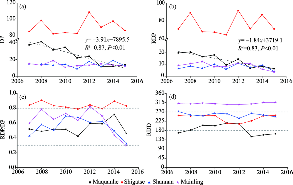
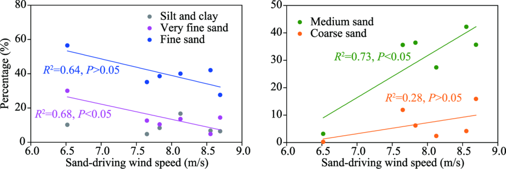
Abstract Aeolian processes have been studied extensively at low elevations, but have been relatively little studied at high elevations. Aeolian sediments are widely distributed in the Yarlung Zangbo River basin, southern Tibetan Plateau, which is characterized by low pressure and low temperature. Here, we comprehensively analyzed the wind regime using data since 1980 from 11 meteorological stations in the study area, and examined the interaction between the near-surface wind and aeolian environment. The wind environment exhibited significant spatial and temporal variation, and mean wind speed has generally decreased on both annual and seasonal bases since 1980, at an average of 0.181 m/(s·10a). This decrease resulted from the reduced contribution of maximum wind speed, and depended strongly on variations of the frequency of sand-driving winds. The drift potential and related parameters also showed obvious spatial and temporal variation, with similar driving forces for the wind environment. The strength of the wind regime affected the formation and development of the aeolian geomorphological pattern, but with variation caused by local topography and sediment sources. The drift potential and resultant drift direction were two key parameters, as they quantify the dynamic conditions and depositional orientation of the aeolian sediments. Wind affected the spatial variation in sediment grain size, but the source material and complex topographic effects on the near-surface wind were the underlying causes for the grain size distribution of aeolian sands. These results will support efforts to control aeolian desertification in the basin and improve our understanding of aeolian processes in high-elevation environments.
|
|
Received: 07 July 2020
Published: 10 November 2020
|
|
Corresponding Authors:
|
About author: *XIA Dunsheng (E-mail: dsxia@lzu.edu.cn)
|
| Cite this article:
YANG Junhuai, XIA Dunsheng, WANG Shuyuan, TIAN Weidong, MA Xingyue, CHEN Zixuan, GAO Fuyuan, LING Zhiyong, DONG Zhibao. Near-surface wind environment in the Yarlung Zangbo River basin, southern Tibetan Plateau. Journal of Arid Land, 2020, 12(6): 917-936.
URL:
http://jal.xjegi.com/10.1007/s40333-020-0104-8 OR http://jal.xjegi.com/Y2020/V12/I6/917
|
|
|
| [1] |
Alexandersson H. 1986. A homogeneity test applied precipitation data. International Journal of Climatology, 6:661-675.
|
|
|
| [2] |
Azorin-Molina C, Vicente-Serrano S M, Mcvicar T R et al. 2014 Homogenization and assessment of observed near-surface wind speed trends over Spain and Portugal, 1961-2011. Journal of Climate, 27(10):3692-3712.
|
|
|
| [3] |
Bagnold R A. 1941. The Physics of Blown Sand and Desert Dunes. London:Methuen, 1-106.
|
|
|
| [4] |
Cui X J, Dong Z B, Sun H, et al. 2017. Spatial and temporal variation of the near-surface wind environment in the dune fields of northern China. International Journal of Climatology, 38(5):2333-2351.
|
|
|
| [5] |
Dong Y X, Li S, Dong G R. 1999. Present status and cause of land desertification in the Yarlung Zangbo River basin. Chinese Geographical Science, 9(3):36-43.
|
|
|
| [6] |
Dong Z B, Hu G Y, Qian G Q, et al. 2017. High-altitude aeolian research on the Tibetan Plateau. Reviews of Geophysics, 55(6):864-901.
|
|
|
| [7] |
Dong Z B, Li Z S. 1998. Wind erodibility of aeolian sand as influenced by grain size parameters. Journal of Soil Erosion and Soil and Water Conservation, 4(4):1-5. (in Chinese)
|
|
|
| [8] |
Dong Z B, Su Z Z, Qian G Q, et al. 2011. Aeolian Geomorphology of the Kumtagh Desert. Beijing: Science Press, 1-314. (in Chinese)
|
|
|
| [9] |
Dong Z B. 2017. Tibetan Plateau Atlas of Aeolian Geomorphology. Xi'an: Xi'an Map Press, 1-116.
|
|
|
| [10] |
Fang X M, Han Y X, Ma J H, et al. 2004. Dust storms and loess accumulation on the Tibetan Plateau: a case study of dust event on 4 March 2003 in Lhasa. Chinese Science Bulletin, 49(9):953-960.
|
|
|
| [11] |
Folk R L, Ward W C. 1957. Brazos River bar: a study in the significance of grain size parameters. Journal of Sedimentary Research, 27(1):3-26.
|
|
|
| [12] |
Fryberger S G, Dean G. 1979. Dune forms and wind regime. In: Mckee E D. A Study of Global Sand Seas. Washington: US Government Printing Office.
|
|
|
| [13] |
Guo H, Xu M, Hu Q. 2011. Changes in near-surface wind speed in China: 1969-2015. International Journal of Climatology, 31(3):349-358.
|
|
|
| [14] |
Han Q J, Qu J, Dong Z B. et al. 2014. The effect of air density on sand transport structures and the Adobe Abrasion Profile: a field wind-tunnel experiment over a wide range of altitude. Boundary-Layer Meteorology, 150(2):299-317.
|
|
|
| [15] |
Han Q J, Qu J, Dong Z B, et al. 2015. Air density effects on aeolian sand movement: implications for sediment transport and sand control in regions with extreme altitudes or temperatures. Sedimentology, 62(4):1024-1038.
|
|
|
| [16] |
Han Y X, Fang X M, Kang S C, et al. 2008. Shifts of dust source regions over central Asia and the Tibetan Plateau: connections with the Arctic oscillation and the westerly jet. Atmospheric Environment, 42(10):2358-2368.
|
|
|
| [17] |
Han Y X, Fang X M, Zhao T L, et al. 2009. Suppression of precipitation by dust particles originated in the Tibetan Plateau. Atmospheric Environment, 43(3):568-574.
doi: 10.1016/j.atmosenv.2008.10.018
|
|
|
| [18] |
He D H, Tian H, Deng W T. 2012. Comparative analysis of the effects of different methods in homogenetiy test on annual wind speed. Transactions of Atmospheric Sciences, 35(3):342-349. (in Chinese)
|
|
|
| [19] |
Jiang Y Y, E CY, Hou G L, et al. 2015. Temporal and spatial distribution of surface wind in the region of northeast Tibetan Plateau. Journal of Qinghai Normal University (Natural Science), 31(1):62-70. (in Chinese)
|
|
|
| [20] |
Kim J C, Paik K. 2015. Recent recovery of surface wind speed after decadal decrease: a focus on South Korea. Climate Dynamics, 45:1699-1712.
|
|
|
| [21] |
Li C, Dong Z B, Yin S Y, et al. 2019. Influence of salinity and moisture on the threshold shear velocity of saline sand in the Qarhan Desert, Qaidam Basin of China: a wind tunnel experiment. Journal of Arid Land, 11(5):674-684.
|
|
|
| [22] |
Li H D, Fang Y, Shen W S, et al. 2011. Spatial distribution and evolution of aeolian sandy land in the areas around Shigatse Peace Airport of Tibet, China since 1975. Journal of Natural Resources, 26(7):1148-1155. (in Chinese)
|
|
|
| [23] |
Li S, Dong G R, Shen JY, et al. 1999. Formation mechanism and development pattern of aeolian sand landform in Yarlung Zangbo River valley. Science in China (Series D), 42(3):273-284.
|
|
|
| [24] |
Li S, Wang Y, Ha S, et al. 1997. Classification and development of aeolian sand landforms in the Yurlung Zangbo Valley. Journal of Desert Research, 17(4):342-350. (in Chinese)
|
|
|
| [25] |
Li S, Yan P, Gao S Y, et al. 2004. Dynamic changes and developmental trends of the land desertification in Tibetan Plateau over the past 10 years. Advances in Earth Science, 19(1):63-70. (in Chinese)
|
|
|
| [26] |
Ling Z Y, Yang S L, Wang X, et al. 2020. Spatial-temporal differentiation of eolian sediments in the Yarlung Tsangpo catchment, Tibetan Plateau, and response to global climate change since the Last Glaciation. Geomorphology, 357:107104.
|
|
|
| [27] |
Liu H, Li X Y, Xiao J H, et al. 2019. Variations of wind erosion climatic erosivity in the Yarlung Zangbo River basin during 1961-2015. Scientia Geographica Sinica, 39(4):688-695. (in Chinese)
doi: 10.13249/j.cnki.sgs.2019.04.019
|
|
|
| [28] |
Liu X N. 2000. The homogeity test on mean annual wind speed over China. Quarterly Journal of Applied Meteorology, 11(1):28-34. (in Chinese)
|
|
|
| [29] |
Liu Y, Wang Y S, Shen T. 2019. Spatial distribution and formation mechanism of aeolian sand in the middle reaches of the Yarlung Zangbo River. Journal of Mountain Science, 16(9):1987-2000.
|
|
|
| [30] |
McVicar T R, Roderick M L, Donohue R J, et al. 2012. Global review and synthesis of trends in observed terrestrial near-surface wind speeds: implications for evaporation. Journal of Hydrology, 416-417:182-205.
|
|
|
| [31] |
Sahu R K. 1964. Depositional mechanisms from the size analysis of clastic sediments. Journal of Sediment Research, 34(1):73-83.
|
|
|
| [32] |
Shen W S, Li H D, Sun M, et al. 2012. Dynamics of aeolian sandy land in the Yarlung Zangbo River basin of Tibet, China from 1975 to 2008. Global and Planetary Change, 86-87:37-44.
|
|
|
| [33] |
Shi P J, Chen Y Q, Zhang AY, et al. 2019. Factors contribution to oxygen concentration in Qinghai-Tibetan Plateau. Chinese Science Bulletin, 64(7):715-724. (in Chinese)
|
|
|
| [34] |
Sun J M, Li S H, Muhs D R, et al. 2007. Loess sedimentation in Tibet: provenance, processes, and link with Quaternary glaciations. Quaternary Science Reviews, 26:2265-2280.
|
|
|
| [35] |
Sun M, Shen W S, Li H D, et al. 2010. Traits and dynamic changes of the aeolian sandy land in the source region of the Yarlung Zangbo River in Tibet. Journal of Natural Resources, 25(7):1163-1171. (in Chinese)
|
|
|
| [36] |
Swet N, Elperin T, Kok J F, et al. 2019. Can active sands generate dust particles by wind-induced processes? Earth and Planetary Science Letters, 506:371-380.
|
|
|
| [37] |
Vautard R, Cattiaux J, Yiou P, et al. 2010. Northern Hemisphere atmospheric stilling partly attributed to an increase in surface roughness. Nature Geoscience, 3(11):756-761.
|
|
|
| [38] |
Wang X M, Lang L L, Yan P, et al. 2016. Aeolian processes and their effect on sandy desertification of the Qinghai-Tibet Plateau: a wind tunnel experiment. Soil and Tillage Research, 158:67-75.
|
|
|
| [39] |
Wu J, Zha J L, Zhao D M. 2016. Estimating the impact of the changes in land use and cover on the surface wind speed over the East China Plain during the period 1980-2011. Climate Dynamics, 46:847-863.
|
|
|
| [40] |
Wu J, Zha J L, Zhao D M, et al. 2018a. Changes of wind speed at different heights over eastern China during 1980-2011. International Journal of Climatology, 38:4476-4495.
|
|
|
| [41] |
Wu J, Zha J L, Zhao D M, et al. 2018b. Changes in terrestrial near-surface wind speed and their possible causes: an overview. Climate Dynamics, 51:2039-2078.
|
|
|
| [42] |
Xu C, Ma Y M, Yang K, et al. 2018. Tibetan Plateau impacts on global dust transport in the upper troposphere. Journal of Climate, 31(12):4745-4756.
|
|
|
| [43] |
Xu M, Chang C, Fu C B, et al. 2006. Steady decline of east Asian monsoon winds, 1969-2000: Evidence from direct ground measurements of wind speed. Journal of Geophysical Research, 111(D24), doi: 10.1029/2006JD007337.
|
|
|
| [44] |
Yang J H, Dong Z B, Liu Z Y, et al. 2019. Migration of barchan dunes in the western Quruq Desert, northwestern China. Earth Surface Processes and Landforms, 44(10):2016-2029.
|
|
|
| [45] |
Yang J H, Xia D S, Gao F Y, et al. 2020. Aeolian deposits in the Yarlung Zangbo River basin, southern Tibetan Plateau: A brief review. Advances in Earth Science, 35(8):863-877. (in Chinese)
|
|
|
| [46] |
Yang Y C, Gao D Y, Li B S. 1989. Study on the moisture passage on the lower reaches of the Yarlung Zangbo River. Science in China (Series D), 32(5):580-593.
|
|
|
| [47] |
Yang Y Y, Liu L Y, Li X Y, et al. 2019. Aerodynamic grain-size distribution of blown sand. Sedimentology, 66:590-603.
|
|
|
| [48] |
Yuan L, Shen W S, Li H D, et al. 2010. Evolution and causes of aeolian desertification of the middle reaches of Yarlung Zangbo River, China. Journal of Ecology and Rural Environment, 26(4):301-305. (in Chinese)
|
|
|
| [49] |
Zeng Z Z, Ziegler A D, Searchinger T, et al. 2019. A reversal in global terrestrial stilling and its implications for wind energy production. Nature Climate Change, 9:979-985.
|
|
|
| [50] |
Zha J L, Wu J. 2017. Effects of land use and cover change on the near-surface wind speed over China in the last 30 years. Progress in Physical Geography, 41(1):46-67.
|
|
|
| [51] |
Zha J L, Wu J, Zhao D M. 2016. Changes of probabilities in different wind grades induced by land use and cover change in Eastern China Plain during 1980-2011. Atmospheric Science Letters: 17:264-269.
|
|
|
| [52] |
Zha J L, Wu J, Zhao D M, et al. 2019. A possible recovery of the near-surface wind speed in Eastern China during winter after 2000 and the potential causes. Theoretical and Applied Climatology, 136:119-134.
|
|
|
| [53] |
Zhang Z C, Dong Z B. 2015. Grain size characteristics in the Hexi Corridor Desert. Aeolian Research, 18:55-67.
|
|
|
| [54] |
Zhang Z C, Dong Z B, Li C X. 2015. Wind regime and sand transport in China's Badain Jaran Desert. Aeolian Research, 17:1-13.
|
|
|
| [55] |
Zhang Z C, Dong Z B, Hu G Y, et al. 2018a. Migration and morphology of asymmetric barchans in the central Hexi Corridor of northwest China. Geosciences, 8(6):204.
|
|
|
| [56] |
Zhang Z C, Dong Z B, Qian G Q, et al. 2018b. Formation and development of dunes in the northern Qarhan Desert, central Qaidam Basin, China. Geological Journal, 53:1123-1134.
|
|
|
| [57] |
Zhang Z T, Wang K C. 2020. Stilling and recovery of the surface wind speed based on observation, reanalysis, and geostrophic wind theory over China from 1960 to 2017. Journal of Cliamte, 33:3989-4008.
|
|
|
| [58] |
Zhou N, Zhang C L, Liu Y G. 2011. Variation of grain size on surface of barchans in Mainling Great valley, Yarlung Zangbo River. Scientia Geographica Sinica, 31(8):958-963. (in Chinese)
|
|
|
| [59] |
Zou X Y, Li S, Zhang C L, et al. 2002. Desertification and control plan in the Tibet Autonomous Region of China. Journal of Arid Environments, 51:183-198.
|
|
|
|
Viewed |
|
|
|
Full text
|
|
|
|
|
Abstract
|
|
|
|
|
Cited |
|
|
|
|
| |
Shared |
|
|
|
|
| |
Discussed |
|
|
|
|