| Research article |
|


|
|
|
| Contribution of groundwater to the formation of sand dunes in the Badain Jaran Desert, China |
WANG Wang1, CHEN Jiaqi2,*( ), CHEN Jiansheng3, WANG Tao4, ZHAN Lucheng4, ZHANG Yitong1, MA Xiaohui5 ), CHEN Jiansheng3, WANG Tao4, ZHAN Lucheng4, ZHANG Yitong1, MA Xiaohui5 |
1College of Civil and Transportation Engineering, Hohai University, Nanjing 210098, China
2School of Computer and Information, Hohai University, Nanjing 210098, China
3Water Science Research Institute, Hohai University, Nanjing 211100, China
4College of Water Conservancy and Hydropower Engineering, Hohai University, Nanjing 210098, China
5Water Affairs Integrated Service Centre of Alagxa League, Inner Mongolia Autonomous Region, Alagxa League 750300, China |
|
|
|
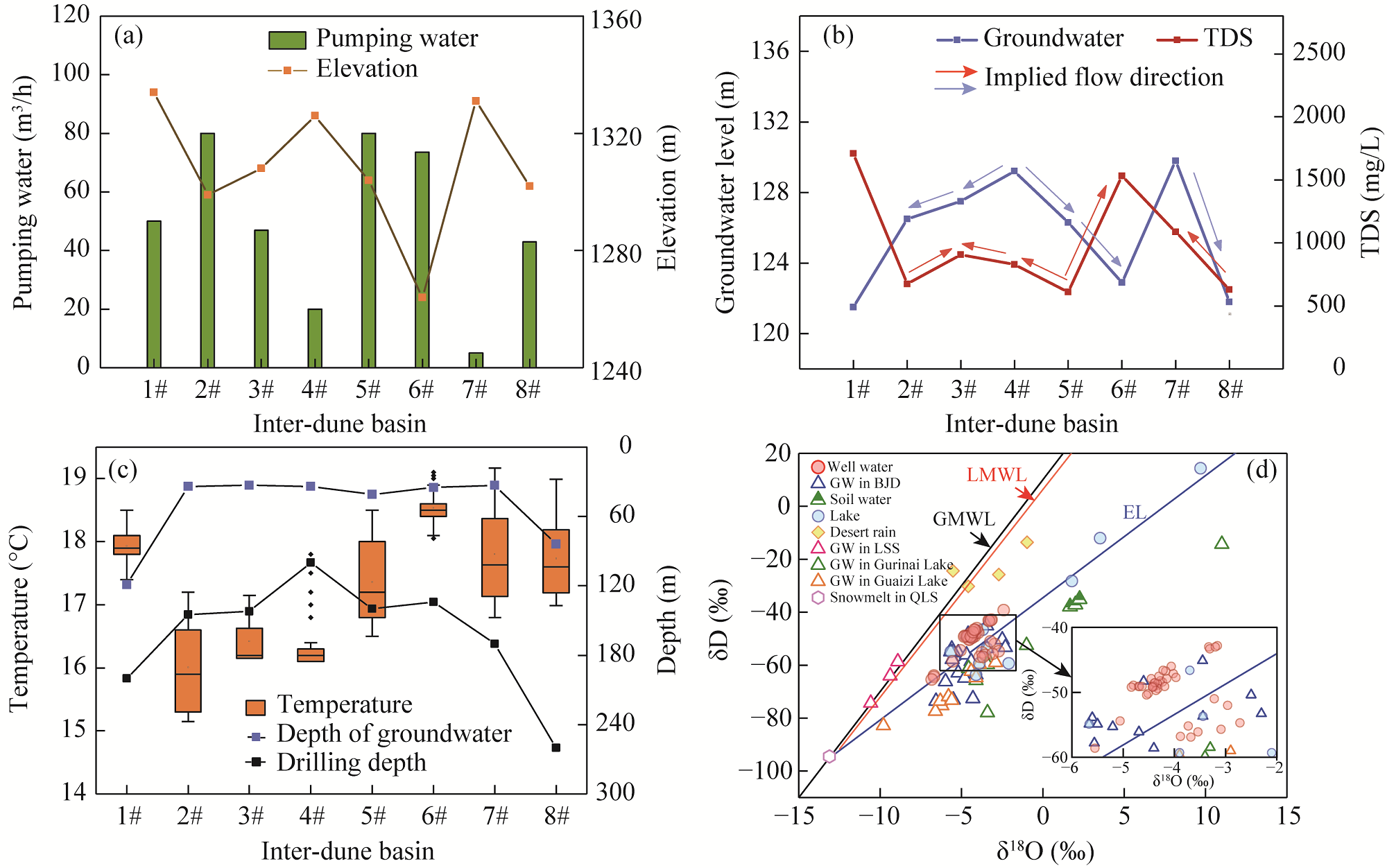
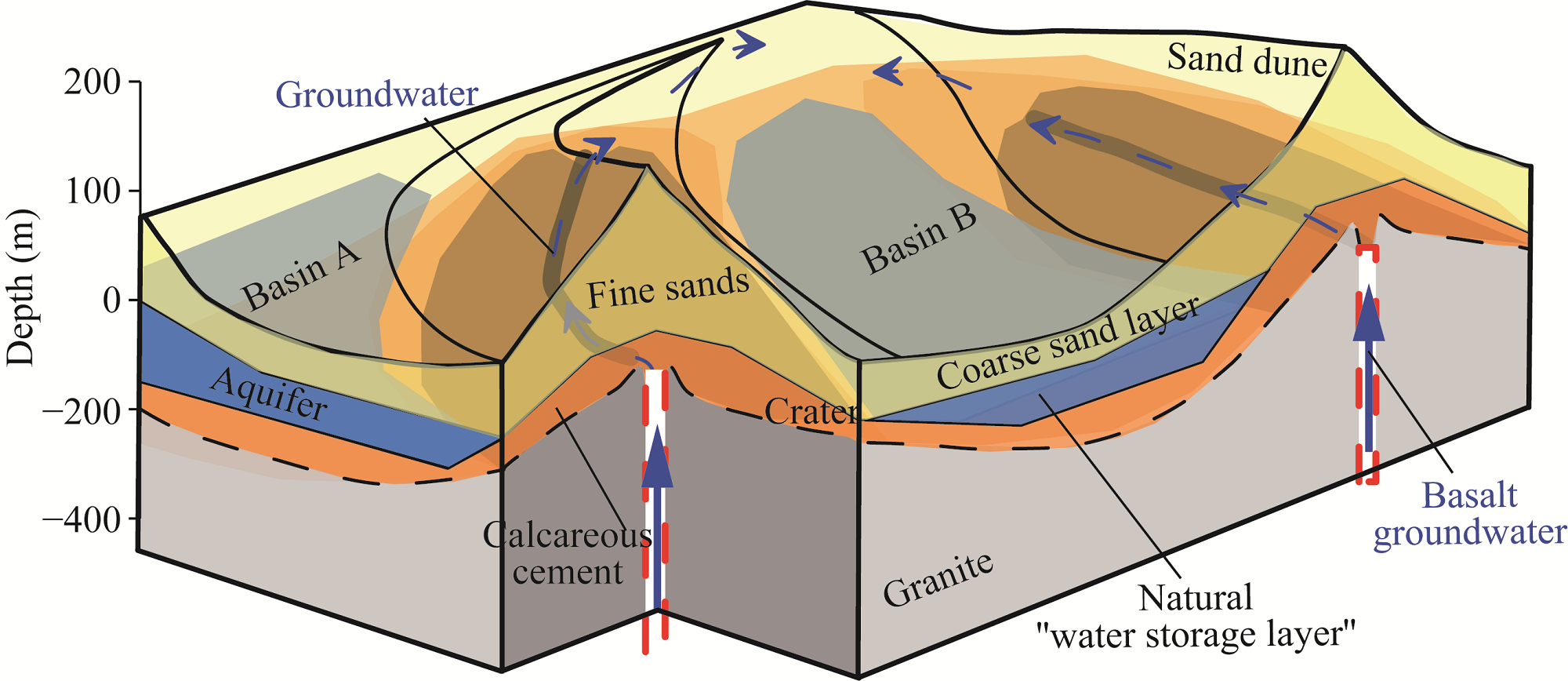
Abstract The tallest sand dune worldwide is located in the Badain Jaran Desert (BJD), China, and has been standing for thousands of years. Previous studies have conducted limited physical exploration and excavation on the formation of sand dunes and have proposed three viewpoints, that is, bedrock control, wind dominance, and groundwater maintenance with no unified conclusion. Therefore, this study analyzed the underlying bedding structure of sand dunes in the BJD. Although the bedrock of sand dunes is uplifted and wind controls the shape of dunes, the main cause of dune formation is groundwater that maintains the deposition of calcareous sandstone and accumulation of aeolian sand. According to water transport model and vapor transports in the unsaturated zone of sand dunes, capillary water transport height is limited with film water constituting the main form of water in dunes. Chemical properties and temperature of groundwater showed that aquifers in different basins receive relatively independent recharge from deep sources in the crater. Result of dune formation mechanism is of considerable importance in understanding groundwater circulation and provides a new perspective on water management in arid desert areas.
|
|
Received: 28 June 2023
Published: 30 November 2023
|
|
Corresponding Authors:
* CHEN Jiaqi (E-mail: jiaqichen@hhu.edu.cn)
|
|
|
| [1] |
Assouline S, Kamai T. 2019. Liquid and vapor water in vadose zone profiles above deep aquifers in hyper-arid environments. Water Resources Research, 55(5): 3619-3631.
doi: 10.1029/2018WR024435
|
|
|
| [2] |
Assouline S, Tyler S W, Selker J S, et al. 2013. Evaporation from a shallow water table: Diurnal dynamics of water and heat at the surface of drying sand. Water Resources Research, 49(7): 4022-4034.
doi: 10.1002/wrcr.v49.7
|
|
|
| [3] |
Bai Y, Wang N, Liao K, et al. 2011. Geomorphological evolution revealed by aeolian sedimentary structure in Badain Jaran Desert on Alxa Plateau, Northwest China. Chinese Geographical Science, 21: 267-278.
doi: 10.1007/s11769-011-0468-y
|
|
|
| [4] |
Chen J, Li L, Wang J, et al. 2004. Groundwater maintains dune landscape. Nature, 432: 459-460.
doi: 10.1038/432459a
|
|
|
| [5] |
Chen J, Zhao X, Sheng X, et al. 2006. Formation mechanisms of megadunes and lakes in the Badain Jaran Desert, Inner Mongolia. Chinese Science Bulletin, 51: 3026-3034.
doi: 10.1007/s11434-006-2196-8
|
|
|
| [6] |
Chen J, Jiang Q. 2015. Research progress of ground water deep circulation. Water Resources Protection, 31(6): 8-17, 66. (in Chinese)
|
|
|
| [7] |
Cheng D, Wang W, Li W, et al. 2010. The unsaturated hydraulic parameters for aeolian sand. Agricultural Science & Technology, 11(10): 1-3. (in Chinese)
|
|
|
| [8] |
Dong C, Wang N, Chen J, et al. 2016. New observational and experimental evidence for the recharge mechanism of the lake group in the Alxa Desert, north-central China. Journal of Arid Environments, 124: 48-61.
doi: 10.1016/j.jaridenv.2015.07.008
|
|
|
| [9] |
Dong Z, Qian G, Luo W, et al. 2009. Geomorphological hierarchies for complex mega-dunes and their implications for mega-dune evolution in the Badain Jaran Desert. Geomorphology, 106(3-4): 180-185.
doi: 10.1016/j.geomorph.2008.10.015
|
|
|
| [10] |
Dong Z, Qian G, Lv P, et al. 2013. Investigation of the sand sea with the tallest dunes on Earth: China's Badain Jaran Sand Sea. Earth-Science Reviews, 120: 20-39.
doi: 10.1016/j.earscirev.2013.02.003
|
|
|
| [11] |
Edmunds W M, Guendouz A H, Mamou A, et al. 2003. Groundwater evolution in the continental intercalaire aquifer of southern Algeria and Tunisia: Trace element and isotopic indicators. Applied Geochemistry, 18(6): 805-822.
doi: 10.1016/S0883-2927(02)00189-0
|
|
|
| [12] |
Gates J B, Edmunds W M, Ma J, et al. 2008. Estimating groundwater recharge in a cold desert environment in northern China using chloride. Hydrogeology Journal, 16: 893-910.
doi: 10.1007/s10040-007-0264-z
|
|
|
| [13] |
Gong Y, Tian R, Li H. 2018. Coupling effects of surface charges, adsorbed counterions and particle-size distribution on soil water infiltration and transport. European Journal of Soil Science, 69(6): 1008-1017.
doi: 10.1111/ejss.2018.69.issue-6
|
|
|
| [14] |
Grandjean G, Paillou P, Dubois-Fernandez P, et al. 2001. Subsurface structures detection by combining L-band polarimetric SAR and GPR data: Example of the Pyla Dune (France). IEEE Transactions on Geoscience and Remote Sensing, 39(6): 1245-1258.
doi: 10.1109/36.927447
|
|
|
| [15] |
Gu W, Chen J, Wang J, et al. 2004. Challenge from the appearance of vadose water within the surface layer of megadunes Badain Jaran Dune desert, Inner Mongolia. Advances in Water Science, 15(6): 695-699. (in Chinese)
|
|
|
| [16] |
Gunn A, Casasanta G, Di Liberto L, et al. 2022. What sets aeolian dune height? Nature Communication, 13: 2401, doi: 10.1038/s41467-022-30031.
|
|
|
| [17] |
Hakimi Y, Orban P, Deschamps P, et al. 2021. Hydrochemical and isotopic characteristics of groundwater in the Continental Intercalaire aquifer system: Insights from Mzab Ridge and surrounding regions, north of the Algerian Sahara. Journal of Hydrology: Regional Studies, 34: 100791, doi: 10.1016/j.ejrh.2021.100791.
|
|
|
| [18] |
Hesse P. 2011. Sticky dunes in a wet desert: Formation, stabilisation and modification of the Australian desert dunefields. Geomorphology, 134(3-4): 309-325.
doi: 10.1016/j.geomorph.2011.07.008
|
|
|
| [19] |
Hu F, Yang X. 2016. Geochemical and geomorphological evidence for the provenance of aeolian deposits in the Badain Jaran Desert, northwestern China. Quaternary Science Reviews, 131: 179-192.
doi: 10.1016/j.quascirev.2015.10.039
|
|
|
| [20] |
Hu W, Wang N, Zhao L, et al. 2015. Surface energy and water vapor fluxes observed on a megadune in the Badain Jaran Desert, China. Journal of Arid Land, 7(5): 579-589.
doi: 10.1007/s40333-015-0129-6
|
|
|
| [21] |
Jia F, Qin Z, Han Z. 1993. Basic characteristics of groundwater in basalt of China. Hydrogeology and Engineering Geology, 20(4): 30-32. (in Chinese)
|
|
|
| [22] |
Jiang Q, Chen J. 2015. Analysis on water balance of deep cycle groundwater supplying Tianchi Lake of Changbai Mountain. Water Resources Protection, 31(5): 7-13. (in Chinese)
|
|
|
| [23] |
Jin K, Rao W B, Tan H B, et al. 2018. H-O isotopic and chemical characteristics of a precipitation-lake water-groundwater system in a desert area. Journal of Hydrology, 559: 848-860.
doi: 10.1016/j.jhydrol.2018.03.005
|
|
|
| [24] |
Kulkarni H, Deolankar S B, Lalwani A, et al. 2000. Hydrogeological framework of the Deccan basalt groundwater systems, west-central India. Hydrogeology Journal, 8: 368-378.
doi: 10.1007/s100400000079
|
|
|
| [25] |
Lancaster N, Kocurek G, Singhvi A, et al. 2002. Late Pleistocene and Holocene dune activity and wind regimes in the western Sahara Desert of Mauritania. Geology, 30(11): 991-994.
doi: 10.1130/0091-7613(2002)030<0991:LPAHDA>2.0.CO;2
|
|
|
| [26] |
Lebeau M, Konrad J M. 2010. A new capillary and thin film flow model for predicting the hydraulic conductivity of unsaturated porous media. Water Resources Research, 46(12): W12554, doi: 10.1029/2010WR009092.
|
|
|
| [27] |
Liu B, Ma Z, Xu J, et al. 2009. Comparison of pan evaporation and actual evaporation estimated by land surface model in Xinjiang from 1960 to 2005. Journal of Geographical Sciences, 19: 502-512.
|
|
|
| [28] |
Liu W, Jiang H, Shi C, et al. 2016. Chemical and strontium isotopic characteristics of the rivers around the Badain Jaran Desert, northwest China: Implication of river solute origin and chemical weathering. Environmental Earth Sciences, 75: 1119, doi: 10.1007/s12665-016-5910-0.
|
|
|
| [29] |
Lorenz R D, Radebaugh J. 2009. Global pattern of Titan's dunes: Radar survey from the Cassini prime mission. Geophysical Research Letters, 36(3): L03202, doi: 10.1029/2008GL036850.
|
|
|
| [30] |
Luo X, Jiao J J, Wang X S, et al. 2016. Temporal 222Rn distributions to reveal groundwater discharge into desert lakes: Implication of water balance in the Badain Jaran Desert, China. Journal of Hydrology, 534: 87-103.
doi: 10.1016/j.jhydrol.2015.12.051
|
|
|
| [31] |
Ma F, Chen J, Zhan L, et al. 2022. Coastal upward discharge of deep basalt groundwater through developed faults: A case study of the Subei Basin, China. Journal of Environmental Management, 306: 114469, doi: 10.1016/j.jenvman.2022.114469.
|
|
|
| [32] |
Ma N, Wang N, Li Z, et al. 2011. Analysis on climate change in northern and southern marginal zones of Badain Juran Desert during 1960-2009. Arid Zone Research, 28(2): 242-250. (in Chinese)
|
|
|
| [33] |
Ma N, Wang N, Zhao L, et al. 2014. Observation of mega-dune evaporation after various rain events in the hinterland of Badain Jaran Desert, China. Chinese Science Bulletin, 59: 162-170.
doi: 10.1007/s11434-013-0050-3
|
|
|
| [34] |
Meng N, Wang N, Zhao L, et al. 2022. Wind regimes and associated sand dune types in the hinterland of the Badain Jaran Desert, China. Journal of Arid Land, 14(5): 473-489.
doi: 10.1007/s40333-022-0063-3
|
|
|
| [35] |
Parteli E J, Herrmann H J. 2007. Dune formation on the present Mars. Physical Review E, 76(4): 41307, doi: 10.1103/PhysRevE.76.041307.
|
|
|
| [36] |
Ping L, Narteau C, Dong Z, et al. 2014. Emergence of oblique dunes in a landscape-scale experiment. Nature Geoscience, 7: 99-103.
doi: 10.1038/ngeo2047
|
|
|
| [37] |
Qian G, Dong Z, Luo W, et al. 2011. Grain size characteristics and spatial variation of surface sediments in the Badain Jaran Desert. Journal of Desert Research, 31(6): 1357-1364. (in Chinese)
|
|
|
| [38] |
Qian R Y, Liu L B. 2015. Internal structure of sand dunes in the Badain Jaran Desert revealed by GPR. IEEE Journal of Selected Topics in Applied Earth Observations and Remote Sensing, 9(1): 159-166.
doi: 10.1109/JSTARS.4609443
|
|
|
| [39] |
Ren J. 1999. A study of chemical characteristics of snow, precipitation and surface water in the basin of the glacier No. 29 in Danghe Nanshan, Qilian Mountains. Journal of Glaciolgy and Geocryology, 21(2): 151-154. (in Chinese)
|
|
|
| [40] |
Sadeghi M, Shokri N, Jones S B. 2012. A novel analytical solution to steady-state evaporation from porous media. Water Resources Research, 48(9): 12060, doi: 10.1029/2012wr012060.
|
|
|
| [41] |
van Genuchten M T. 1980. A closed form equation for predicting the hydraulic conductivity of unsaturated soils. Soil Science Society of America Journal, 44(5): 892-898.
doi: 10.2136/sssaj1980.03615995004400050002x
|
|
|
| [42] |
Wang N, Ma N, Chen H, et al. 2013. A preliminary study of precipitation characteristics in the hinterland of Badain Jaran desert. Advances in Water Science, 24(2): 153-160. (in Chinese)
|
|
|
| [43] |
Wang T. 1990. Formation and evolution of Badain Jaran Desert, China. Journal of Desert Research, 10(4): 29-40. (in Chinese)
|
|
|
| [44] |
Webster A G. 1919. On the angle of repose of wet sand. Proceedings of the National Academy of Sciences, 5(7): 263-265.
|
|
|
| [45] |
Wei G, Zhang C, Li Q, et al. 2022. Grain-size composition of the surface sediments in Chinese deserts and the associated dust emission. CATENA, 219: 106615, doi: 10.1016/j.catena.2022.106615.
|
|
|
| [46] |
Wu Y, Wang N, Zhao L, et al. 2014. Hydrochemical characteristics and recharge sources of Lake Nuoertu in the Badain Jaran Desert. Chinese Science Bulletin, 59: 886-895.
doi: 10.1007/s11434-013-0102-8
|
|
|
| [47] |
Yan M, Wang G, Dong G, et al. 2001. Study on mega dunes development and environmental change in Badain Jaran Desert. Journal of Desert Research, 21(6): 361-366. (in Chinese)
|
|
|
| [48] |
Yang X. 2000. Landscape evolution and precipitation changes in the Badain Jaran Desert during the last 30,000 years. Chinese Science Bulletin, 45(11): 1042-1047.
doi: 10.1007/BF02884988
|
|
|
| [49] |
Yang X, Williams M A J. 2003. The ion chemistry of lakes and late Holocene desiccation in the Badain Jaran Desert, Inner Mongolia, China. CATENA, 51: 45-60.
doi: 10.1016/S0341-8162(02)00088-7
|
|
|
| [50] |
Yang X, Ma N, Dong J, et al. 2010. Recharge to the inter-dune lakes and Holocene climatic changes in the Badain Jaran Desert, western China. Quaternary Research, 73(1): 10-19.
doi: 10.1016/j.yqres.2009.10.009
|
|
|
| [51] |
Yang X, Scuderi L A. 2010. Hydrological and climatic changes in deserts of China since the Late Pleistocene. Quaternary Research, 73(1): 1-9.
doi: 10.1016/j.yqres.2009.10.011
|
|
|
| [52] |
Yang X, Scuderi L, Liu T, et al. 2011. Formation of the highest sand dunes on Earth. Geomorphology, 135(1-2): 108-116.
doi: 10.1016/j.geomorph.2011.08.008
|
|
|
| [53] |
Zhang Z, Liang A, Zhang C, et al. 2021. Gobi deposits play a significant role as sand sources for dunes in the Badain Jaran Desert, Northwest China. CATENA, 206: 105530, doi: 10.1016/j.catena.2021.105530.
|
|
|
| [54] |
Zhao J, Zhang C, Dong Z, et al. 2011. Particle size composition and formation of the mega-dune in the Badain Jaran Desert. Acta Geologica Sinica, 85(8): 1389-1398. (in Chinese)
|
|
|
| [55] |
Zhao J, Ma Y, Luo X, et al. 2017. The discovery of surface runoff in the megadunes of Badain Jaran Desert, China, and its significance. Science China Earth Sciences, 60: 707-719.
doi: 10.1007/s11430-016-9019-2
|
|
|
| [56] |
Zhu B Q. 2023. Paleo-atmospheric precipitation recharged to groundwater in middle-latitude deserts of Northern China. Atmosphere, 14: 774, doi: 10.3390/atmos14050774.
|
|
|
|
Viewed |
|
|
|
Full text
|
|
|
|
|
Abstract
|
|
|
|
|
Cited |
|
|
|
|
| |
Shared |
|
|
|
|
| |
Discussed |
|
|
|
|