| Research article |
|

|
|
|
| Urban growth scenario projection using heuristic cellular automata in arid areas considering the drought impact |
TANG Xiaoyan1,2, FENG Yongjiu1,2,*( ), LEI Zhenkun1,2, CHEN Shurui1,2, WANG Jiafeng1,2, WANG Rong1,2, TANG Panli1,2, WANG Mian1,2, JIN Yanmin1,2, TONG Xiaohua1,2 ), LEI Zhenkun1,2, CHEN Shurui1,2, WANG Jiafeng1,2, WANG Rong1,2, TANG Panli1,2, WANG Mian1,2, JIN Yanmin1,2, TONG Xiaohua1,2 |
1College of Surveying & Geo-Informatics, Tongji University, Shanghai 200092, China
2Shanghai Key Laboratory of Space Mapping and Remote Sensing for Planetary Exploration, Tongji University, Shanghai 200092, China |
|
|
|
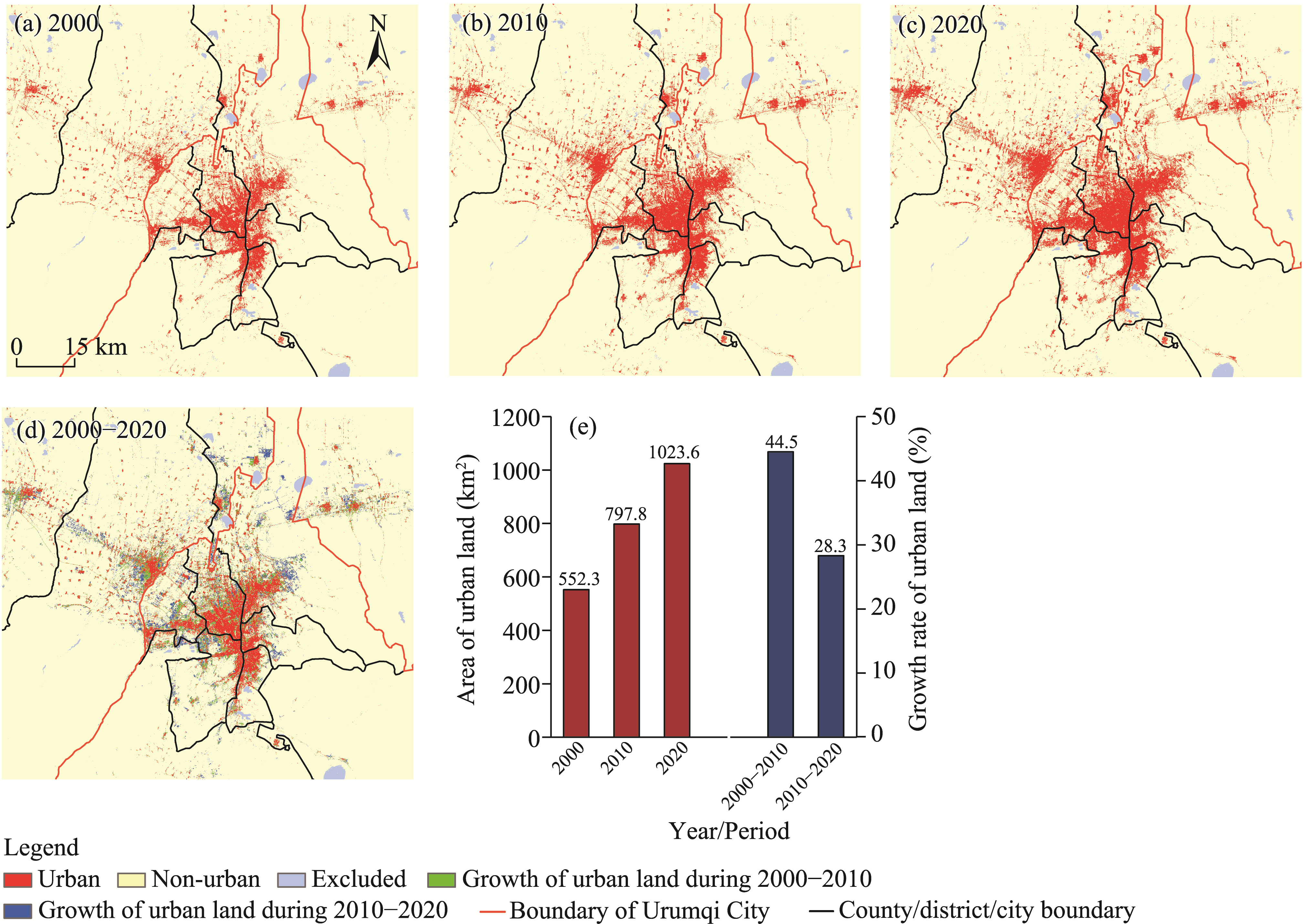
Abstract Arid areas with low precipitation and sparse vegetation typically yield compact urban pattern, and drought directly impacts urban site selection, growth processes, and future scenarios. Spatial simulation and projection based on cellular automata (CA) models is important to achieve sustainable urban development in arid areas. We developed a new CA model using bat algorithm (BA) named bat algorithm-probability-of-occurrence-cellular automata (BA-POO-CA) model by considering drought constraint to accurately delineate urban growth patterns and project future scenarios of Urumqi City and its surrounding areas, located in Xinjiang Uygur Autonomous Region, China. We calibrated the BA-POO-CA model for the drought-prone study area with 2000 and 2010 data and validated the model with 2010 and 2020 data, and finally projected its urban scenarios in 2030. The results showed that BA-POO-CA model yielded overall accuracy of 97.70% and figure-of-merits (FOMs) of 35.50% in 2010, and 97.70% and 26.70% in 2020, respectively. The inclusion of drought intensity factor improved the performance of BA-POO-CA model in terms of FOMs, with increases of 5.50% in 2010 and 7.90% in 2020 than the model excluding drought intensity factor. This suggested that the urban growth of Urumqi City was affected by drought, and therefore taking drought intensity factor into account would contribute to simulation accuracy. The BA-POO-CA model including drought intensity factor was used to project two possible scenarios (i.e., business-as-usual (BAU) scenario and ecological scenario) in 2030. In the BAU scenario, the urban growth dominated mainly in urban fringe areas, especially in the northern part of Toutunhe District, Xinshi District, and Midong District. Using exceptional and extreme drought areas as a spatial constraint, the urban growth was mainly concentrated in the "main urban areas-Changji-Hutubi" corridor urban pattern in the ecological scenario. The results of this research can help to adjust urban planning and development policies. Our model is readily applicable to simulating urban growth and future scenarios in global arid areas such as Northwest China and Africa.
|
|
Received: 13 October 2023
Published: 30 April 2024
|
|
Corresponding Authors:
*FENG Yongjiu (E-mail: yjfeng@tongji.edu.cn)
|
| Cite this article:
TANG Xiaoyan, FENG Yongjiu, LEI Zhenkun, CHEN Shurui, WANG Jiafeng, WANG Rong, TANG Panli, WANG Mian, JIN Yanmin, TONG Xiaohua. Urban growth scenario projection using heuristic cellular automata in arid areas considering the drought impact. Journal of Arid Land, 2024, 16(4): 580-601.
URL:
http://jal.xjegi.com/10.1007/s40333-024-0097-9 OR http://jal.xjegi.com/Y2024/V16/I4/580
|
|
|
| [1] |
Asif M, Kazmi J H, Tariq A, et al. 2023. Modelling of land use and land cover changes and prediction using CA-Markov and random forest. Geocarto International, 38: 2210532, doi: 10.1080/10106049.2023.2210532.
|
|
|
| [2] |
Bayer Altin T, Altin B N. 2021. Response of hydrological drought to meteorological drought in the eastern Mediterranean Basin of Turkey. Journal of Arid Land, 13(5): 470-486.
doi: 10.1007/s40333-021-0064-7
|
|
|
| [3] |
Bie Q, Shi Y, Li X Z, et al. 2023. Contrastive analysis and accuracy assessment of three global 30 m land cover maps circa 2020 in arid land. Sustainability, 15(1): 741, doi: 10.3390/su15010741.
|
|
|
| [4] |
Cai X Y, Yang J, Zhang Y Q, et al. 2023. Cooling island effect in urban parks from the perspective of internal park landscape. Humanities and Social Sciences Communications, 10: 674, doi: 10.1057/s41599-023-02209-5.
|
|
|
| [5] |
Cao M, Bennett S J, Shen Q F, et al. 2016. A bat-inspired approach to define transition rules for a cellular automaton model used to simulate urban expansion. International Journal of Geographical Information Science, 30: 1961-1979.
|
|
|
| [6] |
Cao M, Huang M X, Xu R Q, et al. 2019. A grey wolf optimizer-cellular automata integrated model for urban growth simulation and optimization. Transactions in GIS, 23(4): 672-687.
doi: 10.1111/tgis.v23.4
|
|
|
| [7] |
Chaturvedi V, de Vries W T. 2021. Machine learning algorithms for urban land use planning: a review. Urban Science, 5(3): 68, doi: 10.3390/urbansci5030068.
|
|
|
| [8] |
Civicioglu P, Besdok E. 2013. A conceptual comparison of the Cuckoo-search, particle swarm optimization, differential evolution and artificial bee colony algorithms. Artificial Intelligence Review, 39: 315-346.
doi: 10.1007/s10462-011-9276-0
|
|
|
| [9] |
Dahal K, Lindquist E. 2018. Spatial, temporal and hierarchical variability of the factors driving urban growth: a case study of the Treasure Valley of Idaho, USA. Applied Spatial Analysis and Policy, 11: 481-510.
|
|
|
| [10] |
de Jong L, de Bruin S, Knoop J, et al. 2021. Understanding land-use change conflict: a systematic review of case studies. Journal of Land Use Science, 16(3): 223-239.
doi: 10.1080/1747423X.2021.1933226
|
|
|
| [11] |
Ding Y, Cao K, Qiao W F, et al. 2022. A whale optimization algorithm-based cellular automata model for urban expansion simulation. International Journal of Applied Earth Observation and Geoinformation, 115: 103093, doi: 10.1016/j.jag.2022.103093.
|
|
|
| [12] |
Dong H S, Li R J, Li J M, et al. 2020. Study on urban spatiotemporal expansion pattern of three first-class urban agglomerations in China derived from integrated DMSP-OLS and NPP-VIIRS nighttime light data. Journal of Geo-Information Science, 22(5): 1161-1174. (in Chinese)
|
|
|
| [13] |
Feng Y J, Tong X H. 2018. Calibration of cellular automata models using differential evolution to simulate present and future land use. Transactions in GIS, 22(2): 582-601.
|
|
|
| [14] |
Feng Y J, Tong X H. 2019. A new cellular automata framework of urban growth modeling by incorporating statistical and heuristic methods. International Journal of Geographical Information Science, 34(1): 74-97.
doi: 10.1080/13658816.2019.1648813
|
|
|
| [15] |
Feng Y J, Wang R, Tong X H, et al. 2019. How much can temporally stationary factors explain cellular automata-based simulations of past and future urban growth? Computers, Environment and Urban Systems, 76: 150-162.
|
|
|
| [16] |
Fu R D, Zhang X H, Yang D G, et al. 2021. The relationship between urban vibrancy and built environment: an empirical study from an emerging city in an arid region. International Journal of Environmental Research and Public Health, 18(2): 525, doi: 10.3390/ijerph18020525.
|
|
|
| [17] |
Gao C, Feng Y J, Tong X H, et al. 2020. Modeling urban growth using spatially heterogeneous cellular automata models: Comparison of spatial lag, spatial error and GWR. Computers, Environment and Urban Systems, 81, 101459, doi: 10.1016/j.compenvurbsys.2020.101459.
|
|
|
| [18] |
Gao C, Feng Y J, Xi M R, et al. 2023. An improved assessment method for urban growth simulations across models, regions, and time. International Journal of Geographical Information Science, 37(11): 2345-2366.
doi: 10.1080/13658816.2023.2264942
|
|
|
| [19] |
García A M, Santé I, Boullón M, et al. 2013. Calibration of an urban cellular automaton model by using statistical techniques and a genetic algorithm. Application to a small urban settlement of NW Spain. International Journal of Geographical Information Science, 27(8): 1593-1611.
doi: 10.1080/13658816.2012.762454
|
|
|
| [20] |
Govind N R, Ramesh H. 2020. Exploring the relationship between LST and land cover of Bengaluru by concentric ring approach. Environmental Monitoring and Assessment, 192: 650, doi: 10.1007/s10661-020-08601-x.
pmid: 32959161
|
|
|
| [21] |
Han D R, An H M, Cai H Y, et al. 2023a. How do 2D/3D urban landscapes impact diurnal land surface temperature: Insights from block scale and machine learning algorithms. Sustainable Cities and Society, 99: 104933, doi: 10.1016/j.scs.2023.104933.
|
|
|
| [22] |
Han D R, Xu X L, Qiao Z, et al. 2023b. The roles of surrounding 2D/3D landscapes in park cooling effect: Analysis from extreme hot and normal weather perspectives. Building and Environment, 231, 110053, doi: 10.1016/j.buildenv.2023.110053.
|
|
|
| [23] |
He F, Yang J, Zhang Y Q, et al. 2022. Offshore island connection line: A new perspective of coastal urban development boundary simulation and multi-scenario prediction. Giscience & Remote Sensing, 59(1): 801-821.
|
|
|
| [24] |
Huang B, Zhou Y L, Li Z G, et al. 2019. Evaluating and characterizing urban vibrancy using spatial big data: Shanghai as a case study. Environment and Planning B: Urban Analytics and City Science, 47(9): 1543-1559.
doi: 10.1177/2399808319828730
|
|
|
| [25] |
Huang Y, Liao T J. 2019. An integrating approach of cellular automata and ecological network to predict the impact of land use change on connectivity. Ecological Indicators, 98: 149-157.
doi: 10.1016/j.ecolind.2018.10.065
|
|
|
| [26] |
Hurlimann A, Moosavi S, Browne G R. 2021. Urban planning policy must do more to integrate climate change adaptation and mitigation actions. Land Use Policy, 101, 105188, doi: 10.1016/j.landusepol.2020.105188.
|
|
|
| [27] |
Jafari M, Majedi H, Monavari S M, et al. 2016. Dynamic simulation of urban expansion based on cellular automata and logistic regression model: case study of the Hyrcanian Region of Iran. Sustainability, 8(8): 810, doi: 10.3390/su8080810.
|
|
|
| [28] |
Jayasinghe P, Raghavan V, Yonezawa G. 2021. Exploration of expansion patterns and prediction of urban growth for Colombo City, Sri Lanka. Spatial Information Research, 29: 465-478.
doi: 10.1007/s41324-020-00364-4
|
|
|
| [29] |
Kamusoko C, Gamba J. 2015. Simulating urban growth using a random forest-cellular automata (RF-CA) model. Isprs International Journal of Geo-Information, 4(2): 447-470.
doi: 10.3390/ijgi4020447
|
|
|
| [30] |
Kandt J, Batty M. 2021. Smart cities, big data and urban policy: Towards urban analytics for the long run. Cities, 109: 102992, doi: 10.1016/j.cities.2020.102992.
|
|
|
| [31] |
Ke X L, Qi L Y, Zeng C. 2016. A partitioned and asynchronous cellular automata model for urban growth simulation. International Journal of Geographical Information Science, 30(3/4): 637-659.
doi: 10.1080/13658816.2015.1084510
|
|
|
| [32] |
Kumar V, Singh V K, Gupta K, et al. 2021. Integrating cellular automata and agent-based modeling for predicting urban growth: a case of Dehradun City. Journal of the Indian Society of Remote Sensing, 49: 2779-2795.
doi: 10.1007/s12524-021-01418-2
|
|
|
| [33] |
Lawrence D, Philip G, de Gruchy M W. 2022. Climate change and early urbanism in Southwest Asia: A review. Wiley Interdisciplinary Reviews-Climate Change, 13(1): e741, doi:10.1002/wcc.741.
|
|
|
| [34] |
Lei Z K, Feng Y J, Tong X H, et al. 2022. A spatial error-based cellular automata approach to reproducing and projecting dynamic urban expansion. Geocarto International, 37(2): 560-580.
doi: 10.1080/10106049.2020.1726508
|
|
|
| [35] |
Li D, Huan C Y, Yang J, et al. 2022a. Temporal and spatial distribution changes, driving force analysis and simulation prediction of ecological vulnerability in Liaoning Province, China. Land, 11(7): 1025, doi: 10.3390/land11071025.
|
|
|
| [36] |
Li G D, Sun S, Fang C L. 2018. The varying driving forces of urban expansion in China: Insights from a spatial-temporal analysis. Landscape and Urban Planning, 174: 63-77.
doi: 10.1016/j.landurbplan.2018.03.004
|
|
|
| [37] |
Li P S, Feng Y J, Tong X H, et al. 2022b. Spatial planning-constrained modeling of urban growth in the Yangtze River Delta considering the element flows. Giscience & Remote Sensing, 59(1): 1491-1508.
|
|
|
| [38] |
Li Q M, Feng Y J, Tong X H, et al. 2022c. Firefly algorithm-based cellular automata for reproducing urban growth and predicting future scenarios. Sustainable Cities and Society, 76: 103444, doi: 10.1016/j.scs.2021.103444.
|
|
|
| [39] |
Liang X, Liu X P, Li X, et al. 2018. Delineating multi-scenario urban growth boundaries with a CA-based FLUS model and morphological method. Landscape and Urban Planning, 177: 47-63.
doi: 10.1016/j.landurbplan.2018.04.016
|
|
|
| [40] |
Liu C L, Wang T, Guo Q B. 2018. Factors aggregating ability and the regional differences among China's urban agglomerations. Sustainability, 10(11), 4179, doi: 10.3390/su10114179.
|
|
|
| [41] |
Liu J M, Xiao B, Li Y S, et al. 2021. Simulation of dynamic urban expansion under ecological constraints using a long short term memory network model and cellular automata. Remote Sensing, 13(8): 1499, doi: 10.3390/rs13081499.
|
|
|
| [42] |
Lü J J, Wang Y F, Liang X, et al. 2021. Simulating urban expansion by incorporating an integrated gravitational field model into a demand-driven random forest-cellular automata model. Cities, 109: 103044, doi: 10.1016/j.cities.2020.103044.
|
|
|
| [43] |
Maimaiti B, Chen S S, Kasimu A, et al. 2021. Urban spatial expansion and its impacts on ecosystem service value of typical oasis cities around Tarim Basin, Northwest China. International Journal of Applied Earth Observation and Geoinformation, 104: 102554, doi: 10.1016/j.jag.2021.102554.
|
|
|
| [44] |
Mamattursun A, Yang H, Ablikim K, et al. 2022. Spatiotemporal evolution and driving forces of vegetation cover in the Urumqi River Basin. International Journal of Environmental Research and Public Health, 19(22): 15323, doi: 10.3390/ijerph192215323.
|
|
|
| [45] |
Mamitimin Y, Simayi Z, Mamat A, et al. 2023. FLUS based modeling of the urban LULC in arid and semi-arid region of Northwest China: a case study of Urumqi City. Sustainability, 15(6): 4912, doi: 10.3390/su15064912.
|
|
|
| [46] |
McGarigal K S, Cushman S A, Neel M C, et al. 2015. Fragstats V4: Spatial Pattern Analysis Program for Categorical and Continuous Maps. [2023-09-18]. https://www.researchgate.net/publication/259011515_FRAGSTATS_Spatial_pattern_analysis_program_for_categorical_maps.
|
|
|
| [47] |
Middleton N J, Sternberg T. 2013. Climate hazards in drylands: A review. Earth-Science Reviews, 126: 48-57.
doi: 10.1016/j.earscirev.2013.07.008
|
|
|
| [48] |
Mirbagheri B, Alimohammadi A. 2017. Improving urban cellular automata performance by integrating global and geographically weighted logistic regression models. Transactions in GIS, 21(6): 1280-1297.
doi: 10.1111/tgis.2017.21.issue-6
|
|
|
| [49] |
Mozaffaree Pour N, Oja T. 2021. Urban expansion simulated by integrated cellular automata and agent-based models; an example of Tallinn, Estonia. Urban Science, 5(4): 85, doi: 10.3390/urbansci5040085.
|
|
|
| [50] |
Munshi T, Zuidgeest M, Brussel M, et al. 2014. Logistic regression and cellular automata-based modelling of retail, commercial and residential development in the city of Ahmedabad, India. Cities, 39: 68-86.
doi: 10.1016/j.cities.2014.02.007
|
|
|
| [51] |
Nadoushan M A, Alebrahim A. 2017. Land use dynamics and landscape pattern changes in Khomeinishahr City, Iran. Indian Journal of Geo-Marine Sciences, 46(11): 2361-2366.
|
|
|
| [52] |
Naghibi F, Delavar M R. 2016. Discovery of transition rules for cellular automata using artificial bee colony and particle swarm optimization algorithms in urban growth modeling. Isprs International Journal of Geo-Information, 5(12): 241, doi: 10.3390/ijgi5120241.
|
|
|
| [53] |
Naghibi F, Delavar M R, Pijanowski B. 2016. Urban growth modeling using cellular automata with multi-temporal remote sensing images calibrated by the artificial bee colony optimization algorithm. Sensors, 16(12): 2122, doi: 10.3390/s16122122.
|
|
|
| [54] |
Seevarethnam M, Rusli N, Ling G H T. 2022. Prediction of urban sprawl by integrating socioeconomic factors in the Batticaloa Municipal Council, Sri Lanka. Isprs International Journal of Geo-Information, 11(8): 442, doi: 10.3390/ijgi11080442.
|
|
|
| [55] |
Shen L Y, Cheng G Y, Du X Y, et al. 2022. Can urban agglomeration bring "1+1>2Effect"? A perspective of land resource carrying capacity. Land Use Policy, 117: 106094, doi: 10.1016/j.landusepol.2022.106094.
|
|
|
| [56] |
Shi W X, Zhao X, Zhao J C, et al. 2023. Reliability and consistency assessment of land cover products at macro and local scales in typical cities. International Journal of Digital Earth, 16(1): 486-508.
doi: 10.1080/17538947.2023.2181992
|
|
|
| [57] |
Shimada G. 2022. The impact of climate-change-related disasters on Africa's economic growth, agriculture, and conflicts: can humanitarian aid and food assistance offset the damage? International Journal of Environmental Research and Public Health, 19(1): 467, doi:10.3390/ijerph19010467.
|
|
|
| [58] |
Surya B, Salim A, Hernita H, et al. 2021. Land use change, urban agglomeration, and urban sprawl: a sustainable development perspective of Makassar City, Indonesia. Land, 10(6): 556, doi: 10.3390/land10060556.
|
|
|
| [59] |
Tang X Y, Feng Y J, Gao C, et al. 2023. Entropy-weight-based spatiotemporal drought assessment using MODIS products and Sentinel-1A images in Urumqi, China. Natural Hazards, 119: 387-408.
doi: 10.1007/s11069-023-06131-6
|
|
|
| [60] |
Tong X H, Feng Y J. 2020. A review of assessment methods for cellular automata models of land-use change and urban growth. International Journal of Geographical Information Science, 34(5/6): 866-898.
doi: 10.1080/13658816.2019.1684499
|
|
|
| [61] |
Vicente-Serrano S M, Quiring S M, Peña-Gallardo M, et al. 2020. A review of environmental droughts: Increased risk under global warming? Earth-Science Reviews, 201: 102953, doi: 10.1016/j.earscirev.2019.102953.
|
|
|
| [62] |
Wang R, Feng Y J, Tong X H, et al. 2021. Impacts of spatial scale on the delineation of spatiotemporal urban expansion. Ecological Indicators, 129: 107896, doi: 10.1016/j.ecolind.2021.107896.
|
|
|
| [63] |
Wei L, Zhou L, Sun D Q, et al. 2022. Evaluating the impact of urban expansion on the habitat quality and constructing ecological security patterns: A case study of Jiziwan in the Yellow River Basin, China. Ecological Indicators, 145: 109544, doi: 10.1016/j.ecolind.2022.109544.
|
|
|
| [64] |
Wu F. 2002. Calibration of stochastic cellular automata: the application to rural-urban land conversions. International Journal of Geographical Information Science, 16(8): 795-818.
doi: 10.1080/13658810210157769
|
|
|
| [62] |
Wu J S, Chen B K, Mao J Y, et al. 2018. Spatiotemporal evolution of carbon sequestration vulnerability and its relationship with urbanization in China's coastal zone. Science of the Total Environment, 645: 692-701.
|
|
|
| [66] |
Yang D, Luan W X, Li Y, et al. 2023. Multi-scenario simulation of land use and land cover based on shared socioeconomic pathways: The case of coastal special economic zones in China. Journal of Environmental Management, 335: 117536, doi: 10.1016/j.jenvman.2023.117536.
|
|
|
| [67] |
Yang X S. 2011. Bat algorithm for multi-objective optimisation. International Journal of Bio-Inspired Computation, 3(5): 267-274.
doi: 10.1504/IJBIC.2011.042259
|
|
|
| [68] |
Yang Y, Zhang M J, Zhang Y, et al. 2022. Evaluating the soil evaporation loss rate in a gravel-sand mulching environment based on stable isotopes data. Journal of Arid Land, 14(8): 925-939.
doi: 10.1007/s40333-022-0101-1
|
|
|
| [69] |
Yu J Q, Zhou K L, Yang S L. 2019. Land use efficiency and influencing factors of urban agglomerations in China. Land Use Policy, 88: 104143, doi: 10.1016/j.landusepol.2019.104143.
|
|
|
| [70] |
Yu W B, Yang J, Wu F, et al. 2023. Downscaling mapping method for local climate zones from the perspective of deep learning. Urban Climate, 49: 101500, doi: 10.1016/j.uclim.2023.101500.
|
|
|
| [71] |
Zhai J H, Xiao C W, Feng Z M, et al. 2023. Are there suitable global datasets for monitoring of land use and land cover in the tropics? Evidences from mainland Southeast Asia. Global and Planetary Change, 229: 104233, doi: 10.1016/j.gloplacha.2023.104233.
|
|
|
| [72] |
Zhai S T, Feng Y J, Yan X L, et al. 2021. Using spatial heterogeneity to strengthen the neighbourhood effects of urban growth simulation models. Journal of Spatial Science, 68(2): 319-337.
doi: 10.1080/14498596.2021.1982783
|
|
|
| [73] |
Zhang R, Yang J, Ma X Y, et al. 2023a. Optimal allocation of local climate zones based on heat vulnerability perspective. Sustainable Cities and Society, 99: 104981, doi: 10.1016/j.scs.2023.104981.
|
|
|
| [74] |
Zhang S Y, Shao H Y, Li X Q, et al. 2022a. Spatiotemporal dynamics of ecological security pattern of urban agglomerations in Yangtze River Delta based on LUCC simulation. Remote Sensing, 14(2): 296, doi: 10.3390/rs14020296.
|
|
|
| [75] |
Zhang W, Chang W J, Zhu Z C, et al. 2020. Landscape ecological risk assessment of Chinese coastal cities based on land use change. Applied Geography, 117: 102174, doi: 10.1016/j.apgeog.2020.102174.
|
|
|
| [76] |
Zhang X, Liu L Y, Chen X D, et al. 2021. GLC_FCS30: global land-cover product with fine classification system at 30 m using time-series Landsat imagery. Earth System Science Data, 13(6): 2753-2776.
doi: 10.5194/essd-13-2753-2021
|
|
|
| [77] |
Zhang X, Hao Z C, Singh V P, et al. 2022b. Drought propagation under global warming: Characteristics, approaches, processes, and controlling factors. Science of the Total Environment, 838(Part 2): 156021, doi: 10.1016/j.scitotenv.2022.156021.
|
|
|
| [78] |
Zhang X F, Simayi Z, Yang S T, et al. 2023b. Vulnerability assessment of ecological-economic-social systems in urban agglomerations in arid regions—a case study of Urumqi-Changji-Shihezi urban agglomeration. Sustainability, 15(6): 5414, doi: 10.3390/su15065414.
|
|
|
|
Viewed |
|
|
|
Full text
|
|
|
|
|
Abstract
|
|
|
|
|
Cited |
|
|
|
|
| |
Shared |
|
|
|
|
| |
Discussed |
|
|
|
|