| Research article |
|


|
|
|
| Identification and classification of ecological restoration areas in the territorial land space of the Qaidam Basin, China |
CHENG Lanhua1, YANG Xianming1,2,3,*( ), PAN Xumei4, AN Jingfeng1 ), PAN Xumei4, AN Jingfeng1 |
1College of Geographical Sciences, Qinghai Normal University, Xining 810016, China
2Key Laboratory of Tibetan Plateau Land Surface Processes and Ecological Conservation (Ministry of Education), Xining 810016, China
3Academy of Plateau Science and Sustainability, People's Government of Qinghai Province & Beijing Normal University, Xining 810016, China
4School of Geographical Science, Shanxi Normal University, Taiyuan 030000, China |
|
|
|
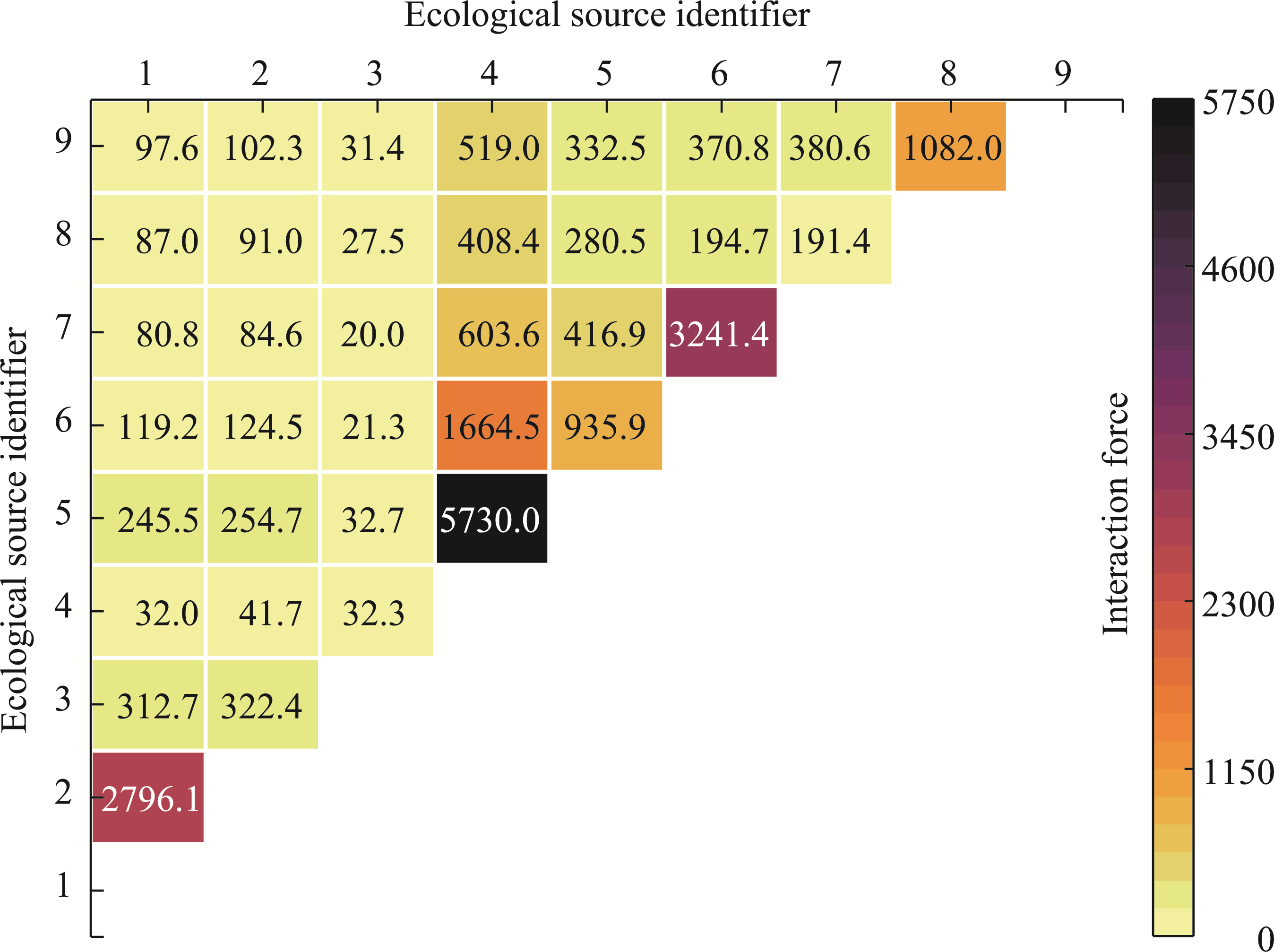
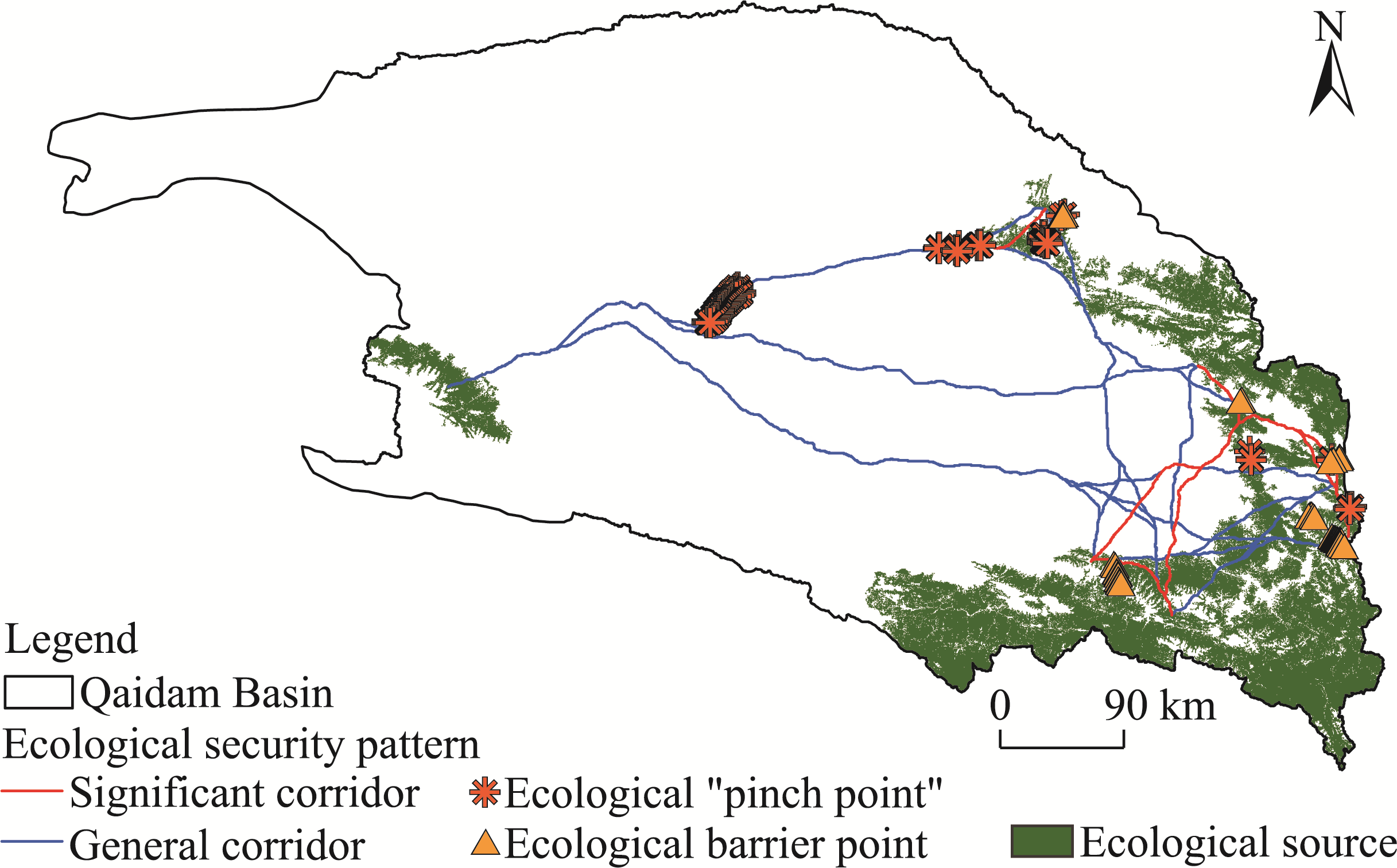
Abstract Territorial spatial ecological restoration is a crucial prerequisite for optimizing the territorial spatial patterns, enhancing the ecosystem functions, and achieving sustainable development at the regional scale. The Qaidam Basin, located in the alpine arid region of the Qinghai-Xizang Plateau, China, is experiencing desertification, biodiversity loss, soil erosion, and environmental pollution. Selecting the Qaidam Basin as the study area, we identified 9 ecological sources in the region using the Morphological Spatial Pattern Analysis (MSPA) method and the landscape connectivity assessment, and extracted 10 significant corridors and 26 general corridors using the Minimum Cumulative Resistance (MCR) and Gravity models. Then, we determined 114 ecological "pinch points" and 42 ecological barrier points by employing the Circuit Theory, thereby constructing the ecological security pattern of the area. Further, we evaluated the ecosystem health of the Qaidam Basin during 2003-2023 using the Vitality-Organization-Resilience-Service (VORS) model. Finally, we integrated ecosystem health assessment and ecological security pattern to comprehensively identify the key areas for ecological restoration in the Qaidam Basin. The results revealed that the ecosystem in the basin fluctuated toward a healthier state from 2003 to 2023. The average ecosystem health index (EHI) for the basin decreased from 0.34 in 2003 to 0.28 in 2013, followed by a substantial recovery to 0.36 in 2023. Higher EHI values were found in the northeastern, southeastern, and southwestern fringes and lower values were located in the basin interior and northwestern region. During 2003-2023, the areas that exhibited a decrease in EHI were primarily located in the interior and northwestern regions of the basin, while those that exhibited an increase in EHI were located in the northeastern, southeastern, and southwestern fringes, demonstrating expanded spatial differences. This may be attributed to the fact that once an eco-environment is damaged, the ecological recovery of the vulnerable areas within the eco-environment will be slow and difficult. This study identified four types of ecological restoration areas, including corridor connectivity, artificial restoration, ecological recovery, and ecological enhancement zones, covering a total area of 6034.7 km2, and proposed targeted ecological restoration strategies according to these different categories. Our findings can serve as a valuable reference for optimizing the territorial spatial patterns, enhancing the ecosystem functions, and promoting sustainable development in the Qaidam Basin.
|
|
Received: 14 March 2025
Published: 31 October 2025
|
|
Corresponding Authors:
*YANG Xianming (E-mail: 21cnyjs@163.com)
|
|
|
| [1] |
Bureau of Statistics of Haixi Mongolian and Tibetan Autonomous Prefecture. 2003-2023. Statistical Communique on National Economic and Social Development of the Haixi Mongolian and Tibetan Autonomous Prefecture. [2025-05-30]. http://tjj.qinghai.gov.cn/tjData/cityBulletin/. (in Chinese)
|
|
|
| [2] |
Bureau of Statistics of Qinghai Province, Survey Team of the National Bureau of Statistics in Qinghai. 2004-2024. Qinghai Province Statistical Yearbook. Beijing: China Statistics Press. (in Chinese)
|
|
|
| [3] |
Cao X F, Liu Z S, Li S J, et al. 2022. Identification of key areas of ecological protection and restoration based on the pattern of ecological security: A case of Songyuan City, Jilin Province. China Environmental Science, 42(6): 2779-2787. (in Chinese)
|
|
|
| [4] |
Chen J, Zhao C C, Zhao Q, et al. 2023. Construction of ecological network in Fujian Province based on morphological spatial pattern analysis. Acta Ecologica Sinica, 43(2): 603-614. (in Chinese)
|
|
|
| [5] |
Chen W X, Zhao X L, Zhong M X, et al. 2022. Spatiotemporal evolution patterns of ecosystem health in the Middle Reaches of the Yangtze River Urban Agglomerations. Acta Ecologica Sinica, 42(1): 138-149. (in Chinese)
|
|
|
| [6] |
Chen X, Peng J, Liu Y X, et al. 2017. Constructing ecological security patterns in Yunfu City based on the framework of importance-sensitivity-connectivity. Geographical Research, 36(3): 471-484. (in Chinese)
|
|
|
| [7] |
Deng X C, Zhu C L, Shi Y F, et al. 2018. The current situation of Qinghai salt lake lithium resources development and the suggestions for lithium industry. Journal of Salt Lake Research, 26(4): 11-18. (in Chinese)
|
|
|
| [8] |
Dou H M, Zhao R F, Chen X D, et al. 2024. Identification of priority areas for territorial space ecological restoration in arid area of Northwest China: A case study of Zhangye City in Heihe River basin. Chinese Journal of Applied Ecology, 35(2): 469-479. (in Chinese)
doi: 10.13287/j.1001-9332.202402.025
|
|
|
| [9] |
Fan Y W, Du H Q, Lu S L, et al. 2023. Modelling of sand/dust emission process in the Zhuonai Lake Watershed, the source of the Yangtze River. Geographical Science, 43(12): 2247-2256. (in Chinese)
|
|
|
| [10] |
Feng X Q, Du Z Y, Tao P Y, et al. 2024. Construction of green space ecological network in Xiongan New Area based on the MSPA-InVEST-MCR model. Applied Sciences, 14(22): 10760, doi: 10.3390/app142210760.
|
|
|
| [11] |
Fu B J, Chen L D, Ma K M, et al. 2001. Principles and Applications of Landscape Ecology. Beijing: Science Press. (in Chinese)
|
|
|
| [12] |
Geng J, Zhang X Y, Guo X N, et al. 2021. Sources of soluble salts in dustfall and their impact on resources and environment in the Qaidam Basin. Acta Geologica Sinica, 95(7): 2082-2098. (in Chinese)
|
|
|
| [13] |
Gong J L, Li H B, Yang H P. 2024. Identification and classification of ecological restoration areas in territorial land space of Wuhan metropolitan area under the perspective of ecological security patterns and ecological vulnerability. Geographical Science, 44(10): 1809-1817. (in Chinese)
|
|
|
| [14] |
Guo J, Wei X J, Zhang F Q, et al. 2025. Remote sensing assessment of ecosystem health and its key driving factors: A case study of the Urban Agglomeration in the Middle Reaches of the Yangtze River. Environment Science, 46(7): 4545-4557. (in Chinese)
|
|
|
| [15] |
Han X L, Liang D H. 2024. Economic analysis of China highland barley industry in China. Food and Nutrition in China, 30(1): 14-18. (in Chinese)
|
|
|
| [16] |
IPBES (Intergovernmental Science-Policy Platform on Biodiversity and Ecosystem Services). 2019. Global assessment report on biodiversity and ecosystem services of the Intergovernmental Science-Policy Platform on Biodiversity and Ecosystem Services. Technical Report. IPBES Secretariat. Bonn, Germany.
|
|
|
| [17] |
Jia H W, Yan C Z, Xing X G. 2021. Evaluation of eco-environmental quality in Qaidam Basin based on the ecological index (MRSEI) and GEE. Remote Sensing, 13(22): 4543, doi: 10.3390/rs13224543.
|
|
|
| [18] |
Lai X Y, Yu H R, Liu G H, et al. 2023. Construction and analysis of ecological security patterns in the southern Anhui region of China from a circuit theory perspective. Remote Sensing, 15(5): 1385, doi: 10.3390/rs15051385.
|
|
|
| [19] |
Li J H, Chen W L, Wang Y. 2025. Construction of ecological security pattern based on the trade-off between the ecological value and realization potential of ecological product value: taking Haixi Prefecture as an example. Resources and Environment in the Yangtze Basin, 34(5): 1097-1112. (in Chinese)
|
|
|
| [20] |
Li J L, Lei Q H, Hu D W, et al. 2024a. Characterization of spatial and temporal correlation between human activity intensity and ecosystem service value in the Yangtze River Economic Zone. Resources and Environment in the Yangtze Basin, 33(9): 1992-2003. (in Chinese)
|
|
|
| [21] |
Li K X, Zhang L, Li H, et al. 2024b. Identification of the key regions of spatial ecological restoration in the Northwest Shanxi based on the MSPA model and circuit theory. Arid Zone Research, 41(9): 1593-1604. (in Chinese)
|
|
|
| [22] |
Li X, Zheng Y, Chen A Y, et al. 2024c. Identification of ecological restoration priority areas based on ecological security patterns and risk assessment: A case study of Shenmu City. Acta Ecologica Sinica, 44(19): 8784-8797. (in Chinese)
|
|
|
| [23] |
Lin L G, Wei X D, Luo P P, et al. 2023. Ecological security patterns at different spatial scales on the Loess Plateau. Remote Sensing, 15(4): 1011, doi: 10.3390/rs15041011.
|
|
|
| [24] |
Liu S K, Qin X H, Lu R C, et al. 2024. Dynamic interactive responses of urbanization and ecosystem health in land border areas in China. China Land Science, 38(9): 122-134. (in Chinese)
|
|
|
| [25] |
Liu Y, Huang T T, Zheng X. 2022a. A method of linking functional and structural connectivity analysis in urban green infrastructure network construction. Urban Ecosystems, 25(3): 909-925.
|
|
|
| [26] |
Liu Y M, Xu N Y, Zeng H. 2022b. Ecosystem health assessment and its scale dependence in the coastal region of the East China Sea. Acta Ecologica Sinica, 42(24): 9913-9926. (in Chinese)
|
|
|
| [27] |
Meng Z Q, Long L B, She Q N, et al. 2018. Assessment of ecological conditions over China's coastal areas based on land use/cover change. Chinese Journal of Applied Ecology, 29(10): 3337-3346.
|
|
|
| [28] |
National Development and Reform Commission. 2004-2024. Compilation of National Agricultural Products Cost and Benefit Data. Beijing: China Statistics Press. (in Chinese)
|
|
|
| [29] |
Ouyang X, Chen J, Wei X, et al. 2024. Exploring key types and threshold effects of land use change impact on ecosystem health in Changsha-Zhouzhou-Xiangtan Urban Agglomeration. Geographical Science, 44(11): 1946-1954. (in Chinese)
|
|
|
| [30] |
Pinto U, Maheshwari B L, Ollerton R L. 2013. Analysis of long-term water quality for effective river health monitoring in peri-urban landscapes—a case study of the Hawkesbury-Nepean river system in NSW, Australia. Environmental Monitoring and Assessment, 185(6): 4551-4569.
doi: 10.1007/s10661-012-2888-2
pmid: 23054266
|
|
|
| [31] |
Rao H H, Pan T, He M Y, et al. 2025. Progress in the study of potassium, lithium, and boron salt resources in salt lakes of the Qaidam Basin on the Qinghai-Tibet Plateau. Acta Geoscientica Sinica, 46(2): 376-396. (in Chinese)
|
|
|
| [32] |
Stober I, Zhong J, Bucher K. 2023. From freshwater inflows to salt lakes and salt deposits in the Qaidam Basin, W China. Swiss Journal of Geosciences, 116(1): 5, doi: 10.1186/s00015-023-00433-4.
|
|
|
| [33] |
Su M R, Xie H, Yue W C, et al. 2019. Urban ecosystem health evaluation for typical Chinese cities along the Belt and Road. Ecological Indicators, 101: 572-582.
|
|
|
| [34] |
Tian R, Zhao Z Q, Song D Y. 2025. Identification of ecological restoration of territorial space based on ecosystem degradation risk and ecological security pattern: A case study of the Chang-Zhu-Tan Metropolitan Area. Environmental Science, 46(3): 1608-1620. (in Chinese)
|
|
|
| [35] |
Wang W Q, Liu X, Liu C H, et al. 2024. Impacts of grazing pressure on ecosystem health in the agro-pastoral intertwined areas of northern China. Acta Ecologica Sinica, 44(14): 6288-6300. (in Chinese)
|
|
|
| [36] |
Wang Y H, Zhao A Z, Liu X F, et al. 2025. Analysis of spatial and temporal evolution of ecosystem health and its driving factors on the Loess Plateau. Environmental Science, 46(7): 4558-4567. (in Chinese)
|
|
|
| [37] |
Xie G D, Zhang C X, Zhang L M, et al. 2015. Improvement of the evaluation method for ecosystem service value based on per unit area. Journal of Natural Resources, 30(8): 1243-1254. (in Chinese)
doi: 10.11849/zrzyxb.2015.08.001
|
|
|
| [38] |
Yang J, Xie B P, Wang T B, et al. 2023. Identification and optimization strategy of ecological security pattern in Maiji District of Gansu, China. Ecological Indicators, 157: 111309, doi: 10.1016/j.ecolind.2023.111309.
|
|
|
| [39] |
Yang L J, Zhang L L, Zhang F N, et al. 2024. A study on the resilience of ecological networks in the Loess Plateau from the perspective of ecological security patterns. Acta Ecologica Sinica, 44(22): 10471-10485. (in Chinese)
|
|
|
| [40] |
Yang Q Y, Zhang H Z, Tang Q. 2022. Ecological restoration zoning of territorial space in Chongqing City based on adaptive cycle model. Acta Geographica Sinica, 77(10): 2583-2598. (in Chinese)
doi: 10.11821/dlxb202210011
|
|
|
| [41] |
Yang R J, Meng W, Shu J M, et al. 2017. Ecological civilization construction for the saline industry in the Qaidam Basin. Strategic Study of CAE, 19(4): 48-54. (in Chinese)
doi: 10.15302/J-SSCAE-2017.04.008
|
|
|
| [42] |
Yang Y K, Wang Y, Cheng X, et al. 2020. Establishment of an ecological security pattern based on connectivity index: A case study of the Three Gorges Reservoir Area in Chongqing. Acta Ecologica Sinica, 40(15): 5124-5136. (in Chinese)
|
|
|
| [43] |
Zeng C, Cheng Y J, Lü T Y. 2022. Research on land-space ecological restoration zoning based on ecosystem health: A case study of the urban agglomeration in the middle reaches along the Yangtze River. Journal of Natural Resources, 37(12): 3118-3135. (in Chinese)
doi: 10.31497/zrzyxb.20221207
|
|
|
| [44] |
Zhang H T, Li J L, Tian P, et al. 2022. Construction of ecological security patterns and ecological restoration zones in the city of Ningbo, China. Journal of Geographical Sciences, 32(4): 663-681.
doi: 10.1007/s11442-022-1966-9
|
|
|
| [45] |
Zhao Y L, Han R, Cui N, et al. 2021. The impact of urbanization on ecosystem health in typical karst areas: A case study of Liupanshui City, China. International Journal of Environment Research and Public Health, 18(1): 93, doi: 10.3390/ijerph18010093.
|
|
|
| [46] |
Zhou G J, Huan Y Z, Wang L Q, et al. 2023. Linking ecosystem services and circuit theory to identify priority conservation and restoration areas from an ecological network perspective. Science of the Total Environment, 873: 162261, doi: 10.1016/j.scitotenv.2023.162261.
|
|
|
| [47] |
Zhu Q, Cai Y L. 2024. Impact of ecological risk and ecosystem health on ecosystem services. Acta Geographica Sinica, 79(5): 1303-1317. (in Chinese)
doi: 10.11821/dlxb202405013
|
|
|
|
Viewed |
|
|
|
Full text
|
|
|
|
|
Abstract
|
|
|
|
|
Cited |
|
|
|
|
| |
Shared |
|
|
|
|
| |
Discussed |
|
|
|
|