| Research article |
|


|
|
|
| Synergistic trade-off between desertification and lake evolution in the eastern Qinghai Lake region since the late Last Glacial Interstadial: Evidence from aeolian sediments |
HU Mengjun1,*( ), XU Aokang1,2 ), XU Aokang1,2 |
1College of Geography and Environmental Science, Northwest Normal University, Lanzhou 730070, China
2Department of Geology, Northwest University, Xi'an 710069, China |
|
|
|
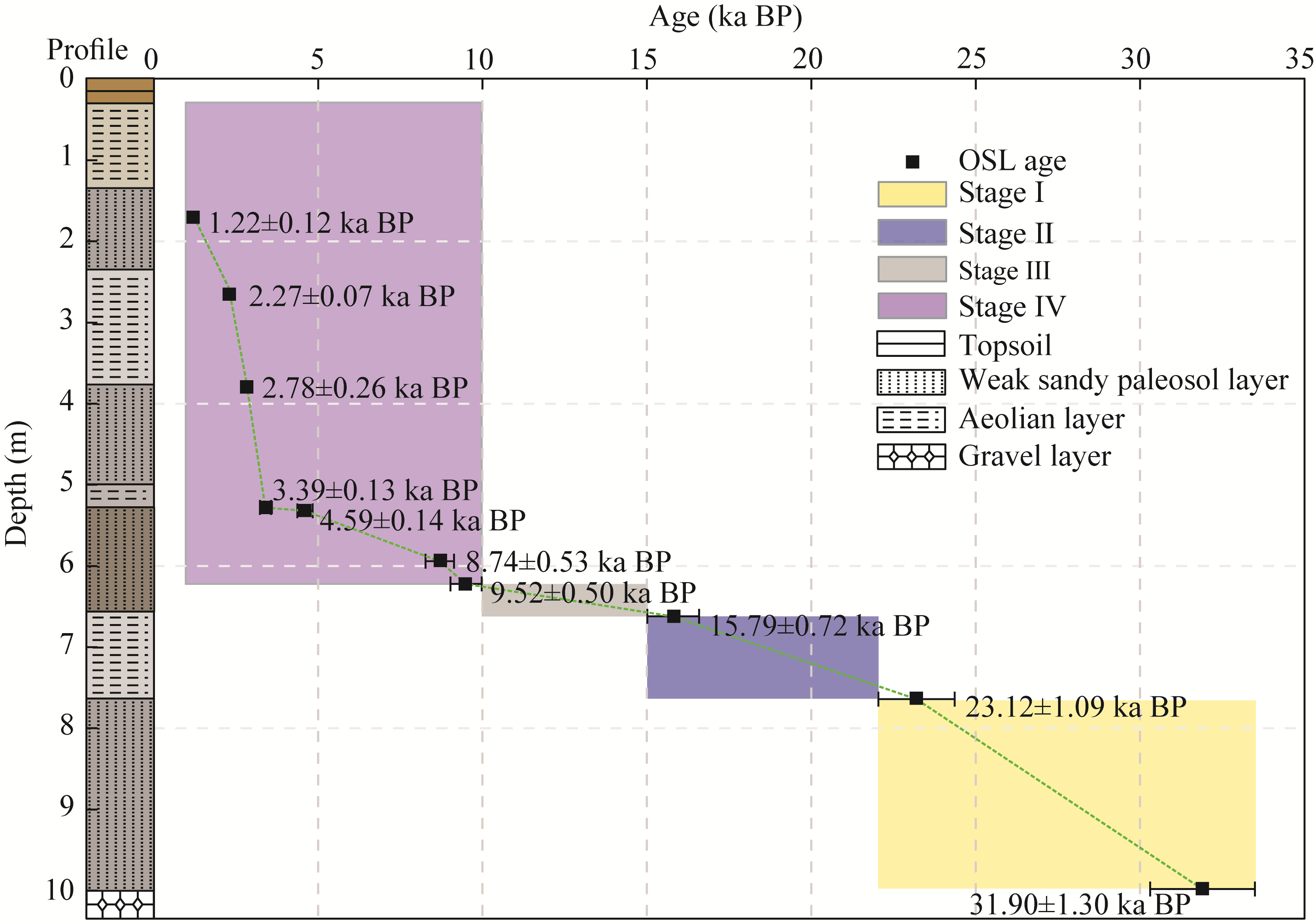
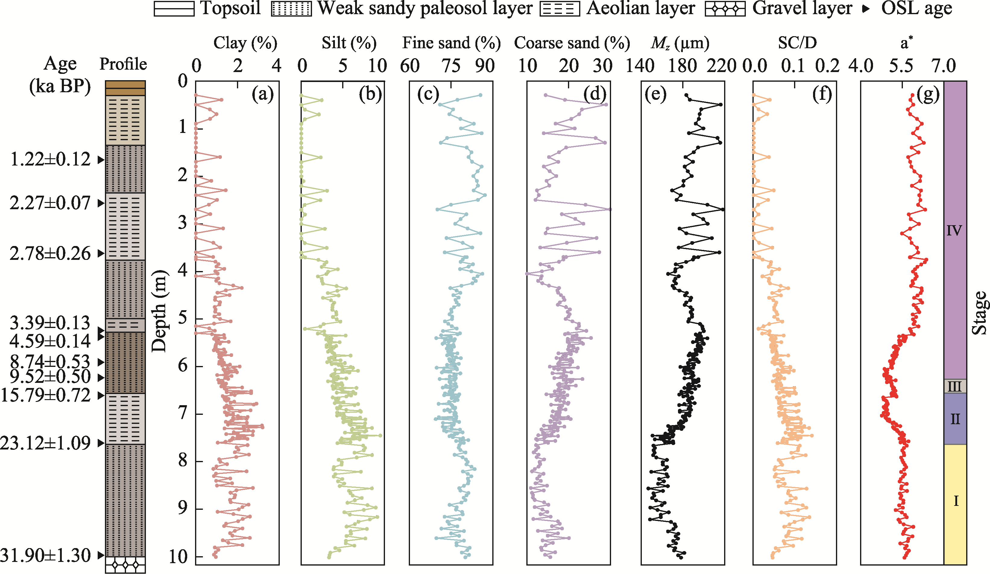
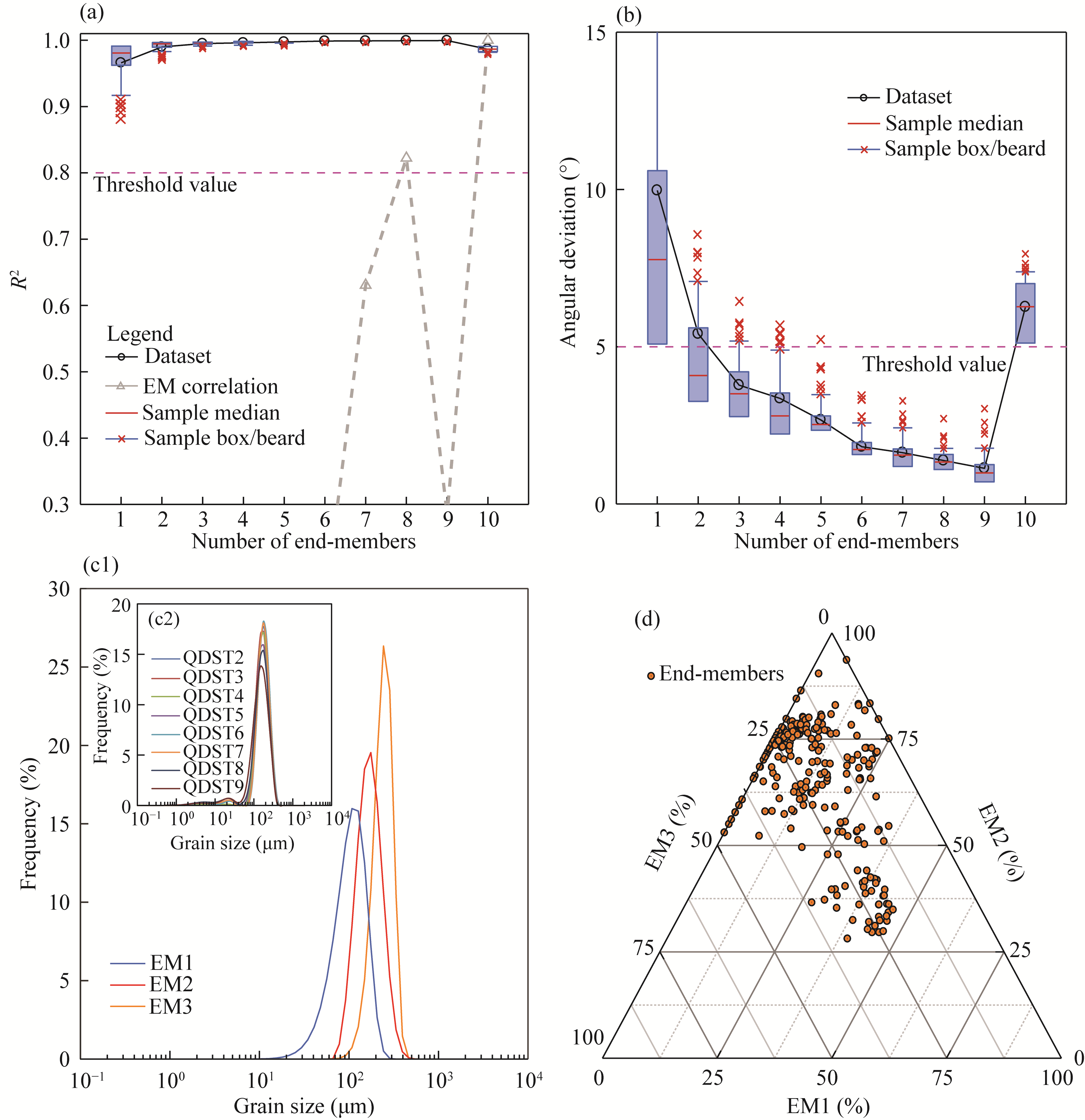
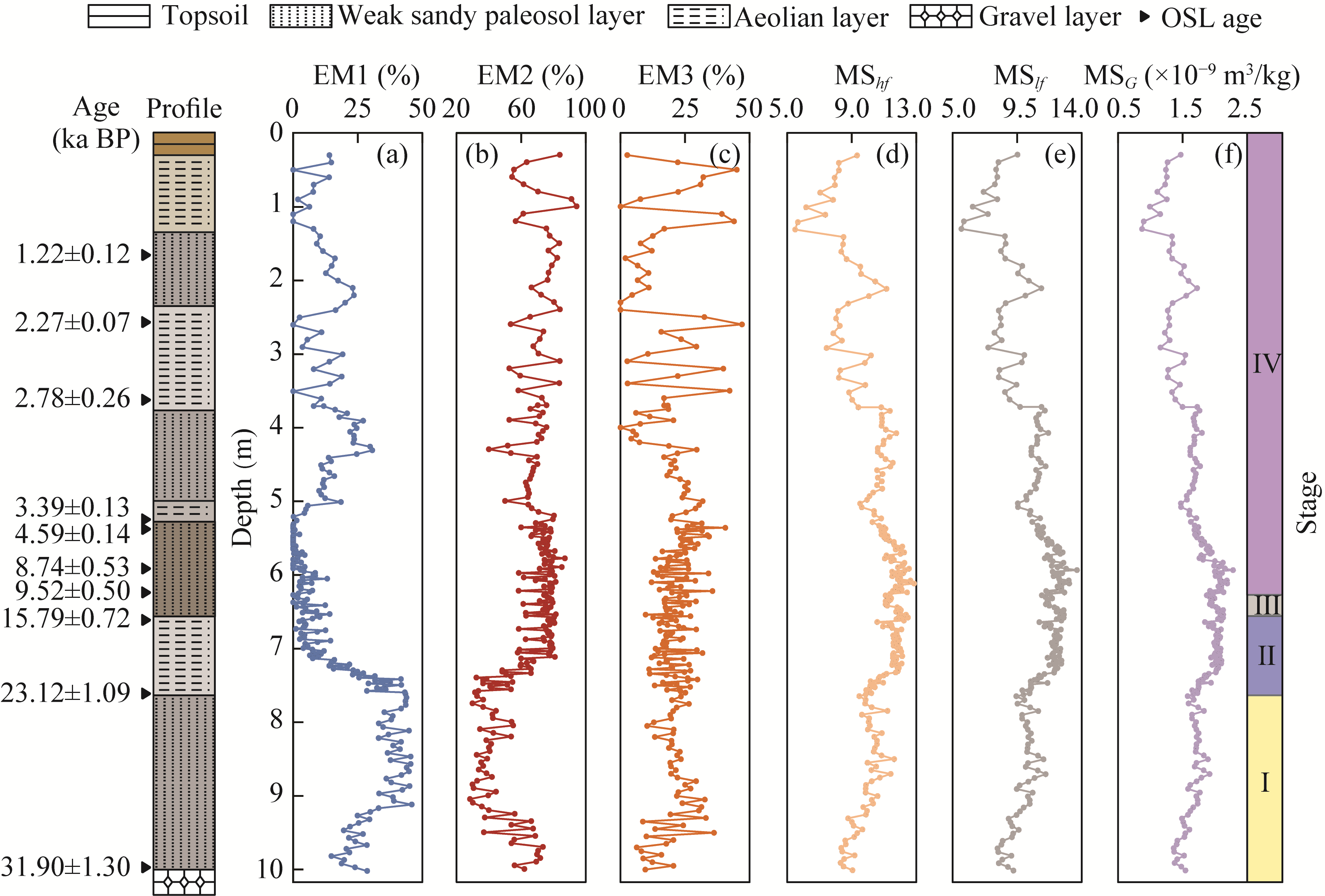
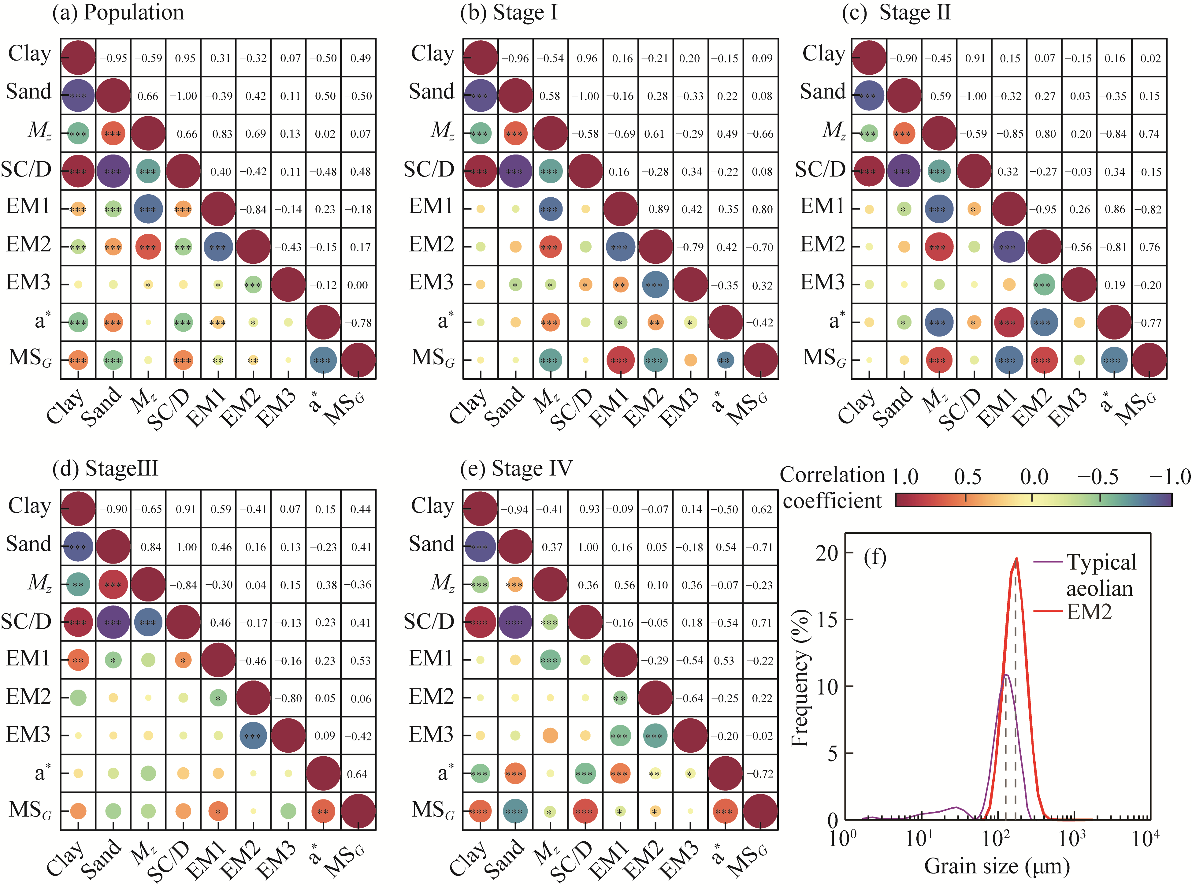
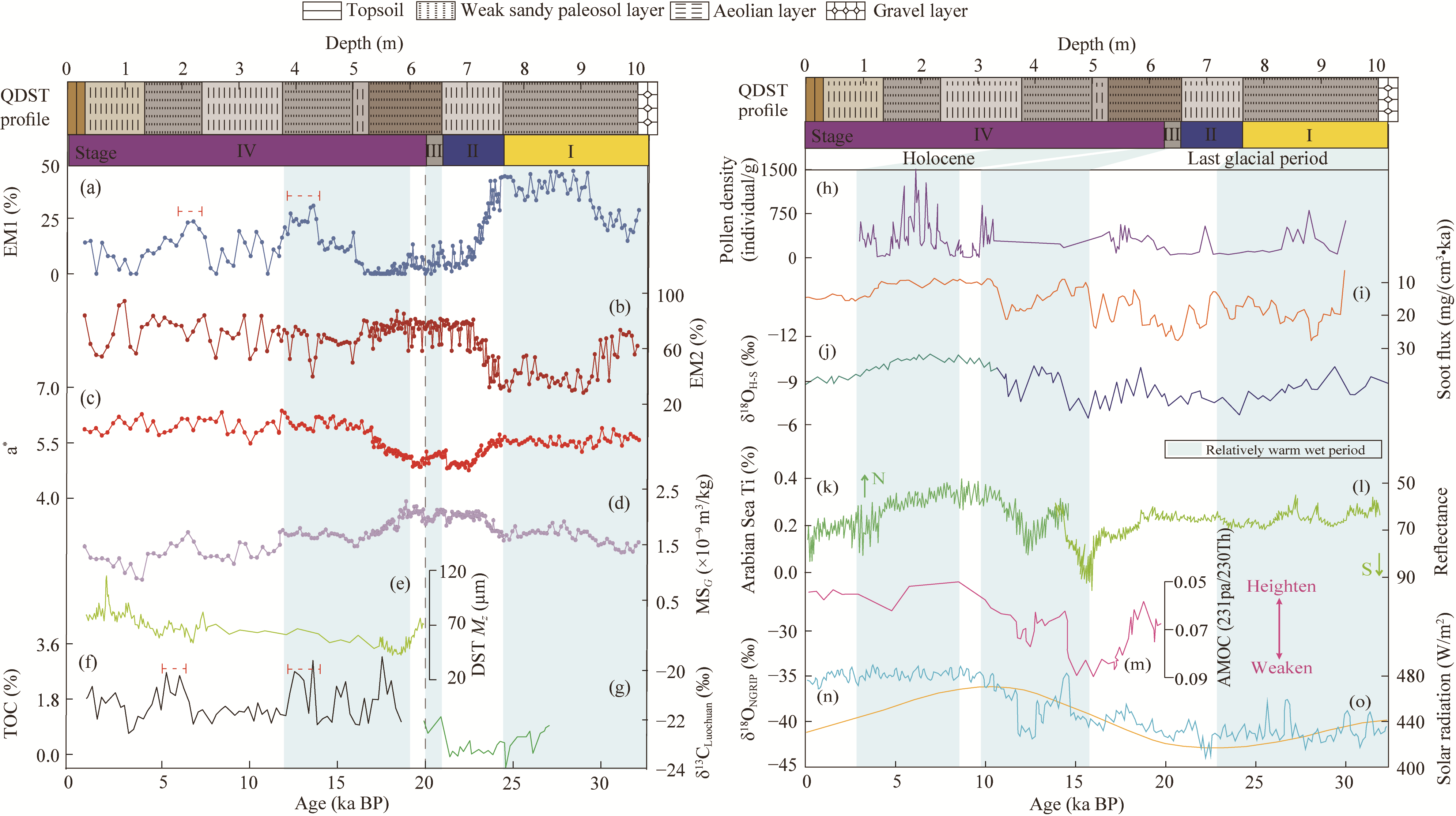
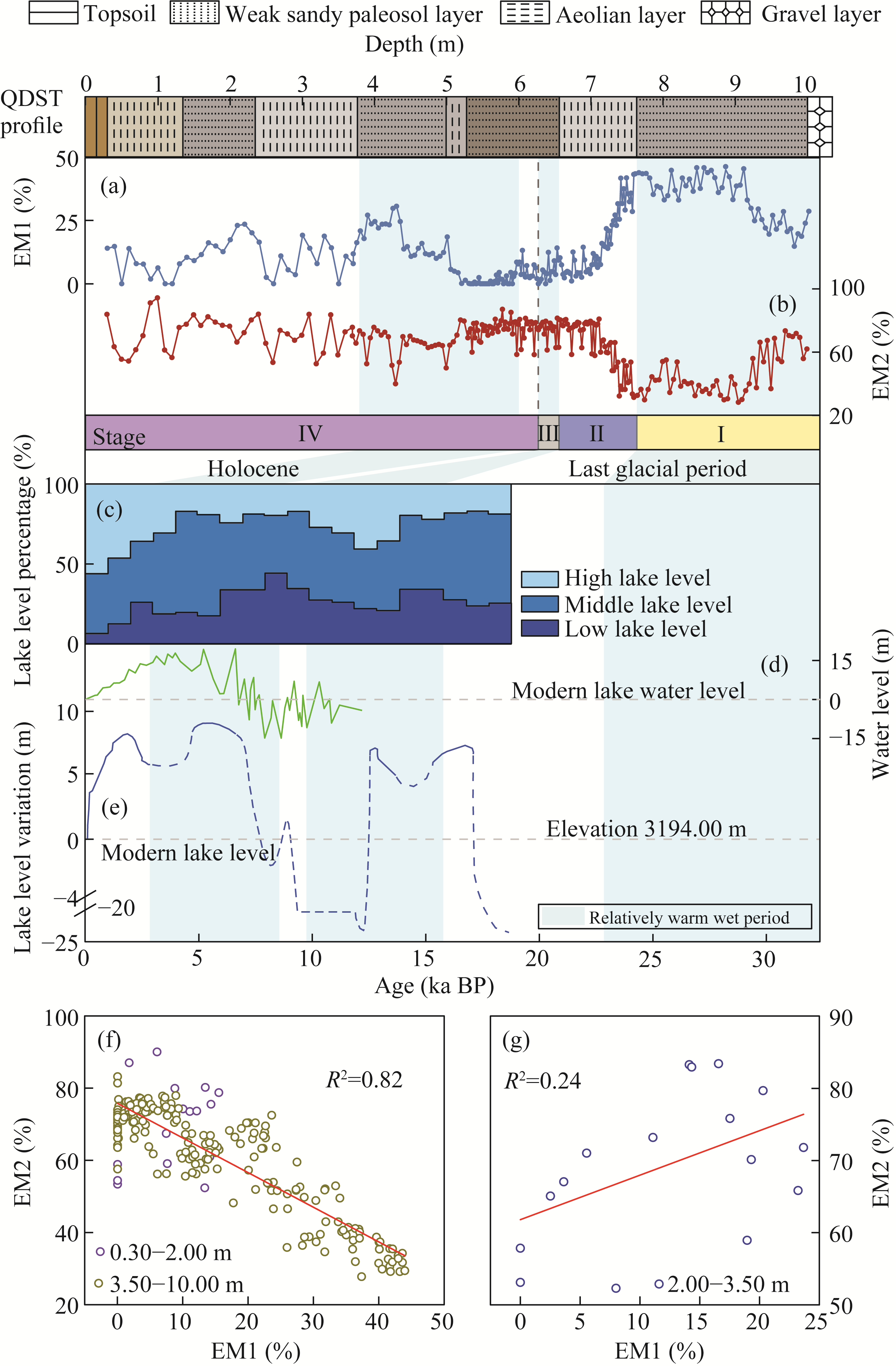
Abstract Aeolian sediments in the eastern Qinghai Lake region, China serve as sensitive paleoclimate archives, offering an ideal window into past environmental conditions. This study investigated the Dashuitang (QDST) profile in the eastern Qinghai Lake region by integrating sediment grain size, chroma, and magnetic susceptibility (MS) proxies to reconstruct the regional environmental evolution since the Last Glacial Interstadial and to investigate its relationship with the water level fluctuations of Qinghai Lake. Grain size end-member modeling analysis (EMMA) identified three end-members: end-member 1 (EM1) represented fine-grained material transported over longer distances through mixing processes, which could reveal the regional moisture conditions; end-member 2 (EM2) primarily consisted of coarse-grained material from nearby sources transported via saltation or creep, indicating the intensity of the winter monsoon; and end-member 3 (EM3) mainly reflected deposition from dust storm events controlled by regional low-altitude wind systems. In addition, the regional environmental sequence demonstrated coherence with other records, collectively elucidating the sub-orbital-scale dynamics of the Asian monsoon. The environmental sequence was divided into four principal phases on the basis of sedimentary characteristics and climatic responses: the late Last Glacial Interstadial, Last Glacial Maximum, Last Deglaciation, and Holocene phases. Additionally, the results of this study revealed that there is a close linkage between desertification and lake evolution in the eastern Qinghai Lake region. Since the Last Glacial Interstadial, desertification and lake evolution processes have generally exhibited a trade-off relationship, wherein lake level decline and desert expansion exhibited a direct positive feedback. However, during the early period of the Late Holocene (approximately 2.80-1.50 ka BP), a synergistic response pattern emerged, characterized by relatively high lake levels alongside moderate desert expansion, reflecting an asymmetric decoupling mechanism between the hydrological processes and aeolian dynamics during climatic transition periods. This study provides important insights for predicting the future evolution trends of lake-desert systems under climate change.
|
|
Received: 01 October 2025
Published: 31 March 2026
|
|
Corresponding Authors:
*HU Mengjun (E-mail: lele200466@163.com)
|
| About author: First author contact:The first and second authors contributed equally to this work. |
|
|
| [1] |
An Z S, Colman S M, Zhou W J, et al. 2012. Interplay between the Westerlies and Asian monsoon recorded in Lake Qinghai sediments since 32 ka. Scientific Reports, 2: 619, doi: 10.1038/srep00619.
|
|
|
| [2] |
Bai M, Lu R J, Ding Z Y, et al. 2020. End-member analysis of grain-size in the east of Qinghai Lake and its environmental implications. Quaternary Sciences, 40(5): 1203-1215. (in Chinese)
|
|
|
| [3] |
Berger A, Loutre M F. 1991. Insolation values for the climate of the last 10 million years. Quaternary Science Reviews, 10(4): 297-317.
doi: 10.1016/0277-3791(91)90033-Q
|
|
|
| [4] |
Chen F H, Wang S L, Zhang W X, et al. 1991. The loess profile at south bank, climatic information and lake-level fluctuations of Qinghai Lake during the Holocene. Geographical Science, 11(1): 76-85. (in Chinese)
|
|
|
| [5] |
Chen F H, Wu D, Chen J H, et al. 2016. Holocene moisture and East Asian summer monsoon evolution in the northeastern Tibetan Plateau recorded by Lake Qinghai and its environs: A review of conflicting proxies. Quaternary Science Reviews, 154: 111-129.
doi: 10.1016/j.quascirev.2016.10.021
|
|
|
| [6] |
Deplazes G, Lückge A, Peterson C L, et al. 2013. Links between tropical rainfall and North Atlantic climate during the last glacial period. Nature Geoscience, 6(3): 213-217.
doi: 10.1038/ngeo1712
|
|
|
| [7] |
E C Y, Zhang J, Chen Z Y, et al. 2019. High resolution OSL dating of aeolian activity at Qinghai Lake, Northeast Tibetan Plateau. CATENA, 183: 104180, doi: 10.1016/j.catena.2019.104180.
|
|
|
| [8] |
Fleming S J. 1970. Thermoluminescent dating: refinement of the quartz inclusion method. Archaeometry, 12(2): 133-143.
doi: 10.1111/arch.1970.12.issue-2
|
|
|
| [9] |
Giosan L, Flood D R, Aller C R. 2002. Paleoceanographic significance of sediment color on western North Atlantic drifts: I. Origin of color. Marine Geology, 189(1-2): 25-41.
doi: 10.1016/S0025-3227(02)00321-3
|
|
|
| [10] |
Hao Y F, Han Y M, An Z S, et al. 2020. Climatic control of orbital time-scale wildfire occurrences since the late MIS 3 at Qinghai Lake, monsoon marginal zone. Quaternary International, 550: 20-26.
doi: 10.1016/j.quaint.2020.03.002
|
|
|
| [11] |
He R X, Jin H J, Vanderberghe J, et al. 2022. Permafrost and paleoenvironments on the northeastern Qinghai-Tibet Plateau, China during the local last permafrost maximum. International Geology Review, 65(15): 2332-2347.
doi: 10.1080/00206814.2022.2137860
|
|
|
| [12] |
Hu M J, Xu A K, Sun W L, et al. 2024. Grain size end-member characteristics of the aeolian sediments in the east of Qinghai Lake and its environmental significance since 32 ka BP. Geoscience, 38(2): 487-496. (in Chinese)
|
|
|
| [13] |
Jin Z D, An Z S, Yu J M, et al. 2015. Lake Qinghai sediment geochemistry linked to hydroclimate variability since the last glacial. Quaternary Science Reviews, 122: 63-73.
doi: 10.1016/j.quascirev.2015.05.015
|
|
|
| [14] |
Kelts K, Chen K Z, Lister G. 1989. Geological fingerprints of climate history: a cooperative study of Qinghai Lake, China. Eclogae Geologicae Helvetiae, 82(1): 167-182.
|
|
|
| [15] |
Lai Z P, Kaiser K, Brückner H. 2009. Luminescence-dated aeolian deposits of late Quaternary age in the southern Tibetan Plateau and their implications for landscape history. Quaternary Research, 72(3): 421-430.
doi: 10.1016/j.yqres.2009.07.005
|
|
|
| [16] |
Li G Q, Jin M, Duan Y W, et al. 2015. Quartz and K-feldspar luminescence dating of a Marine Isotope Stage 5 megalake in the Juyanze Basin, central Gobi Desert, China. Palaeogeography, Palaeoclimatology, Palaeoecology, 440: 96-109.
doi: 10.1016/j.palaeo.2015.08.033
|
|
|
| [17] |
Lin B H, Liu R M, An Z S. 1991. Preliminary research on stable isotopic compositions of Chinese Loess. In: Liu D S. Loess Environment and Global Change. Beijing: Science Press, 124-131. (in Chinese)
|
|
|
| [18] |
Liu X J, Lai Z P, Fan Q S, et al. 2010. Timing for high lake levels of Qinghai Lake in the Qinghai-Tibetan Plateau since the Last Interglaciation based on quartz OSL dating. Quaternary Geochronology, 5(2-3): 218-222.
doi: 10.1016/j.quageo.2009.03.010
|
|
|
| [19] |
Liu X J, Lai Z P, Yu L P, et al. 2012. Luminescence chronology of aeolian deposits from the Qinghai Lake area in the northeastern Qinghai-Tibetan Plateau and its palaeoenvironmental implications. Quaternary Geochronology, 10: 37-43.
doi: 10.1016/j.quageo.2012.01.016
|
|
|
| [20] |
Liu X J, Lai Z P, Madsen D, et al. 2015. Last deglacial and Holocene lake level variations of Qinghai Lake, north-eastern Qinghai-Tibetan Plateau. Journal of Quaternary Science, 30(3): 245-257.
doi: 10.1002/jqs.2777
|
|
|
| [21] |
Liu X J, Cong L, An F Y, et al. 2019. Downwind aeolian sediment accumulations associated with lake-level variations of the Qinghai Lake during the Holocene, northeastern Qinghai-Tibetan Plateau. Environmental Earth Sciences, 78: 19, doi: 10.1007/s12665-018-8025-y.
|
|
|
| [22] |
Long H, Lai Z P, Fuchs M, et al. 2012. Timing of Late Quaternary palaeolake evolution in Tengger Desert of northern China and its possible forcing mechanisms. Global and Planetary Change, 92-93: 119-129.
doi: 10.1016/j.gloplacha.2012.05.014
|
|
|
| [23] |
Lu H Y, Zhao C F, Mason J, et al. 2011. Holocene climatic changes revealed by aeolian deposits from the Qinghai Lake area (northeastern Qinghai-Tibetan Plateau) and possible forcing mechanisms. The Holocene, 21(2): 297-304.
doi: 10.1177/0959683610378884
|
|
|
| [24] |
Lu R J, Jia F F, Gao S Y, et al. 2015. Holocene aeolian activity and climatic change in Qinghai Lake Basin, northeastern Qinghai-Tibetan Plateau. Palaeogeography, Palaeoclimatology, Palaeoecology, 430: 1-10.
doi: 10.1016/j.palaeo.2015.03.044
|
|
|
| [25] |
McManus J F, Francois R, Gherardi J M, et al. 2004. Collapse and rapid resumption of Atlantic meridional circulation linked to deglacial climate changes. Nature, 428: 834-837.
doi: 10.1038/nature02494
|
|
|
| [26] |
Paterson G A, Heslop D. 2015. New methods for unmixing sediment grain size data. Geochemistry Geophysics Geosystems, 16(12): 4494-4506.
doi: 10.1002/ggge.v16.12
|
|
|
| [27] |
Patterson E M, Gillette D A. 1977. Commonalities in measured size distributions for aerosols having a soil-derived component. Journal of Geophysical Research, 82(15): 2074-2082.
doi: 10.1029/JC082i015p02074
|
|
|
| [28] |
Pullen A, Kapp P, McCallister A T, et al. 2011. Qaidam Basin and northern Tibetan Plateau as dust sources for the Chinese Loess Plateau and paleoclimatic implications. Geology, 39(11): 1031-1034.
doi: 10.1130/G32296.1
|
|
|
| [29] |
Pye K. 1987. Aeolian Dust and Dust Deposits. London: Academic Press, 127-238.
|
|
|
| [30] |
Qin X G, Cai B G, Mu Y, et al. 2009. A physcial model of loess dust transport process. Quaternary Sciences, 29(6): 1154-1161. (in Chinese)
|
|
|
| [31] |
Rhode D, Ma H Z, Madsen B M, et al. 2010. Paleoenvironmental and archaeological investigations at Qinghai Lake, western China: Geomorphic and chronometric evidence of lake level history. Quaternary International, 218(1-2): 29-44.
doi: 10.1016/j.quaint.2009.03.004
|
|
|
| [32] |
Schneider T, Bischoff T, Haug G H. 2014. Migrations and dynamics of the intertropical convergence zone. Nature, 513: 45-53.
doi: 10.1038/nature13636
|
|
|
| [33] |
Shi J A, Guo X L, Wang Q, et al. 2003. Geochemistry of REE in QH 1 sediments of Qinghai Lake since Late Holocene and its paleoclimatic significance. Journal of Lake Sciences, 15(1): 28-34. (in Chinese)
doi: 10.18307/2003.0104
|
|
|
| [34] |
Song Y G, Zong X L, Qian L B, et al. 2020. Mineralogical record for stepwise hydroclimatic changes in Lake Qinghai sediments since the last glacial period. Minerals, 10(11): 963, doi: 10.3390/min10110963.
|
|
|
| [35] |
Sun J M, Li S H, Muhs D R, et al. 2007. Loess sedimentation in Tibet: provenance, processes, and link with Quaternary glaciations. Quaternary Science Reviews, 26(17-18): 2265-2280.
doi: 10.1016/j.quascirev.2007.05.003
|
|
|
| [36] |
Vriend M, Prins M A, Buylaert J P, et al. 2011. Contrasting dust supply patterns across the north-western Chinese Loess Plateau during the last glacial-interglacial cycle. Quaternary International, 240(1-2): 167-180.
doi: 10.1016/j.quaint.2010.11.009
|
|
|
| [37] |
Wang X X, Yan P, Zhang X, et al. 2023. Climate and environmental changes recorded by aeolian sediment during the last glaciation in the western Qaidam Basin. Geomorphology, 440: 108878, doi: 10.1016/j.geomorph.2023.108878.
|
|
|
| [38] |
Wang Y J, Cheng H, Edwards R L, et al. 2008. Millennial- and orbital-scale changes in the East Asian monsoon over the past 224,000 years. Nature, 451: 1090-1093.
doi: 10.1038/nature06692
|
|
|
| [39] |
Wang Z, Liu X J, Cong L. 2017. Reconstruction of the desert areas during Last Glacial Maximum and Early Holocene at the eastern side of Qinghai Lake. Journal of Salt Lake Research, 25(2): 67-75. (in Chinese)
|
|
|
| [40] |
Xie H, Liu C C, Zhang H P, et al. 2024. Reconstruction of paleowind direction in the Qinghai Lake area during the last deglacial: Insights from anisotropy of magnetic susceptibility. Palaeogeography, Palaeoclimatology, Palaeoecology, 650: 112351, doi: 10.1016/j.palaeo.2024.112351.
|
|
|
| [41] |
Xu A K, Hu M J, Bai Q Z. 2024. Evolution of the Asian monsoon recorded by Holocene aeolian sediments in the northeastern Tibetan Plateau. Journal of Asian Earth Sciences, 263: 106021, doi: 10.1016/j.jseaes.2024.106021.
|
|
|
| [42] |
Xu S Y, Xu D F. 1983. A primary observation of aeolian sand deposits on eastern shore of the Qinghai Lake. Journal of Desert Research, 3(3): 15-21, 2 (in Chinese)
|
|
|
| [43] |
Yang S L, Liu X J, Cheng T, et al. 2021. Stepwise weakening of aeolian activities during the Holocene in the Gannan Region, eastern Tibetan Plateau. Frontiers in Earth Science, 9: 686677, doi: 10.3389/feart.2021.686677.
|
|
|
| [44] |
Yao T D, Thompson L G, Shi Y F, et al. 1997. Climate variation since the Last Interglaciation recorded in the Guliya ice core. Science in China Series D: Earth Sciences, 40: 662-668.
|
|
|
| [45] |
Zhang F J, Xue B, Yu G. 2021. Lake level changes of central-northern Eurasia and their indicative significance for paleoclimate since Last Glacial Maximum. Acta Geographica Sinica, 76(11): 2673-2684. (in Chinese)
doi: 10.11821/dlxb202111006
|
|
|
| [46] |
Zhang J R, Liu Q, Yang L H, et al. 2022. Regional hydroclimates regulate the Holocene aeolian accumulation processes of the Qinghai Lake basin on the northeastern Tibetan Plateau. CATENA, 210: 105866, doi: 10.1016/j.catena.2021.105866.
|
|
|
| [47] |
Zhang P X, Zhang B Z, Qian G M, et al. 1994. The study of paleoclimatic parameter of Qinghai Lake since Holocene. Quaternary Sciences, 3: 225-236. (in Chinese)
|
|
|
| [48] |
Zhu L P, Zhen X L, Wang J B, et al. 2009. A -30,000-year record of environmental changes inferred from Lake Chen Co, southern Tibet. Journal of Paleolimnology, 42: 343-358.
doi: 10.1007/s10933-008-9280-9
|
|
|
|
Viewed |
|
|
|
Full text
|
|
|
|
|
Abstract
|
|
|
|
|
Cited |
|
|
|
|
| |
Shared |
|
|
|
|
| |
Discussed |
|
|
|
|