| Research article |
|


|
|
|
| Assessing the effects of vegetation and precipitation on soil erosion in the Three-River Headwaters Region of the Qinghai-Tibet Plateau, China |
HE Qian1, DAI Xiao'ai1,*( ), CHEN Shiqi2 ), CHEN Shiqi2 |
1College of Earth Science, Chengdu University of Technology, Chengdu 610059, China
2College of Foreign Languages and Cultures, Chengdu University of Technology, Chengdu 610059, China |
|
|
|
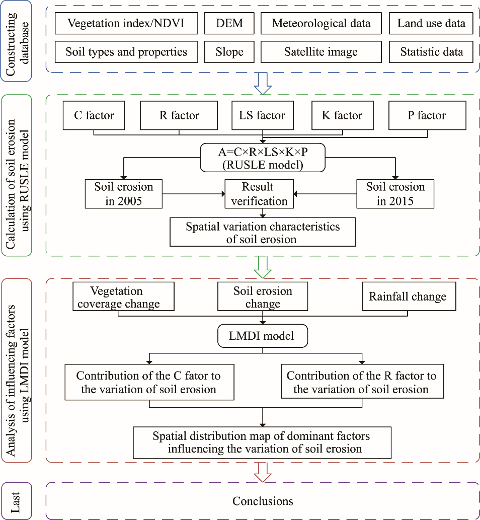
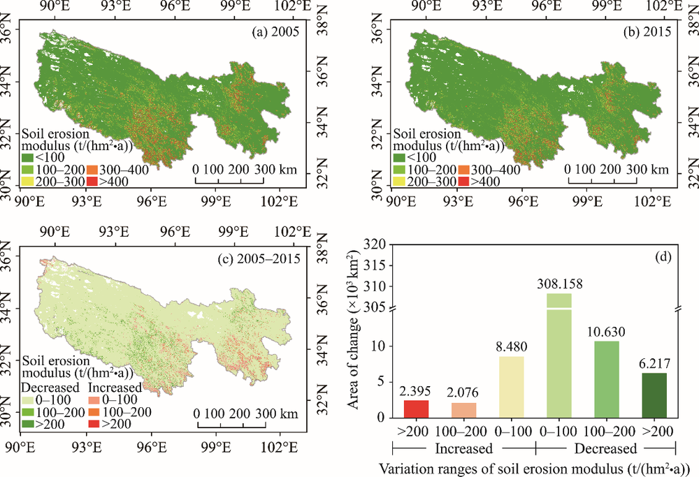
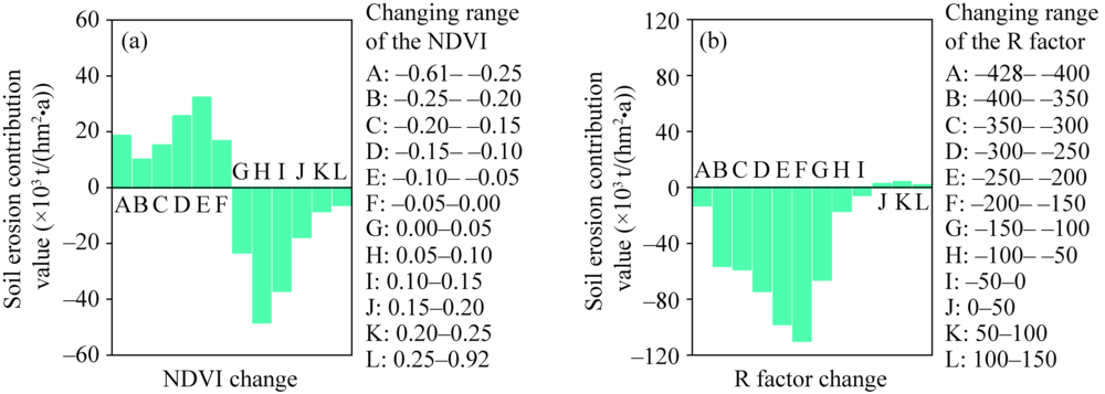
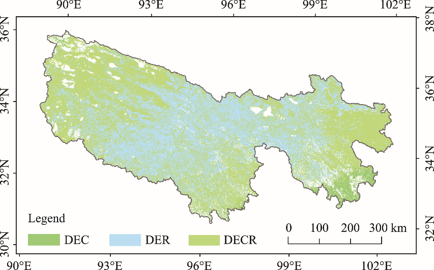
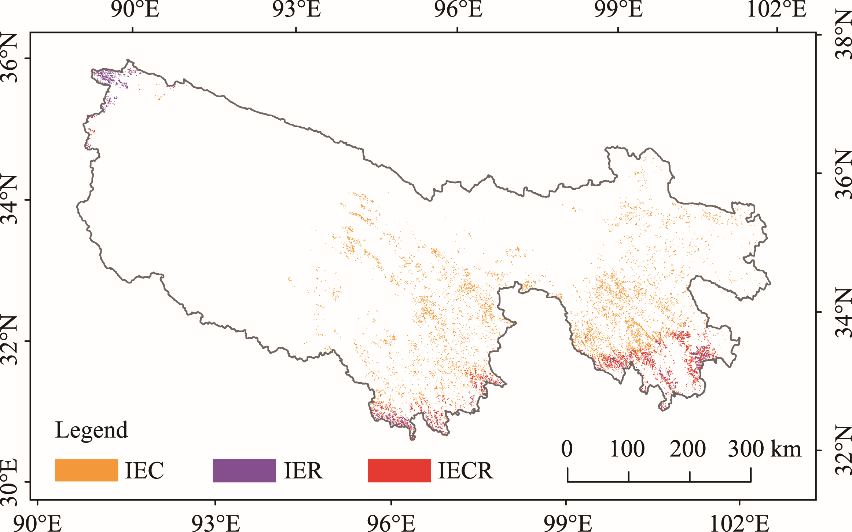
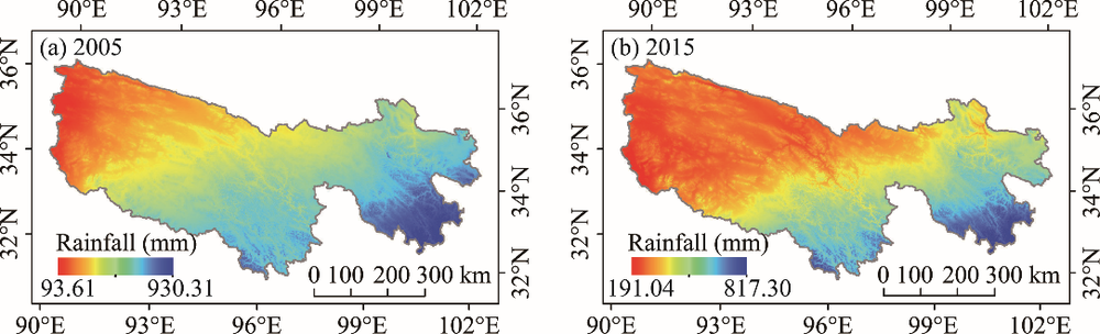
Abstract Soil erosion in the Three-River Headwaters Region (TRHR) of the Qinghai-Tibet Plateau in China has a significant impact on local economic development and ecological environment. Vegetation and precipitation are considered to be the main factors for the variation in soil erosion. However, it is a big challenge to analyze the impacts of precipitation and vegetation respectively as well as their combined effects on soil erosion from the pixel scale. To assess the influences of vegetation and precipitation on the variation of soil erosion from 2005 to 2015, we employed the Revised Universal Soil Loss Equation (RUSLE) model to evaluate soil erosion in the TRHR, and then developed a method using the Logarithmic Mean Divisia Index model (LMDI) which can exponentially decompose the influencing factors, to calculate the contribution values of the vegetation cover factor (C factor) and the rainfall erosivity factor (R factor) to the variation of soil erosion from the pixel scale. In general, soil erosion in the TRHR was alleviated from 2005 to 2015, of which about 54.95% of the area where soil erosion decreased was caused by the combined effects of the C factor and the R factor, and 41.31% was caused by the change in the R factor. There were relatively few areas with increased soil erosion modulus, of which 64.10% of the area where soil erosion increased was caused by the change in the C factor, and 23.88% was caused by the combined effects of the C factor and the R factor. Therefore, the combined effects of the C factor and the R factor were regarded as the main driving force for the decrease of soil erosion, while the C factor was the dominant factor for the increase of soil erosion. The area with decreased soil erosion caused by the C factor (12.10×10³ km2) was larger than the area with increased soil erosion caused by the C factor (8.30×10³ km2), which indicated that vegetation had a positive effect on soil erosion. This study generally put forward a new method for quantitative assessment of the impacts of the influencing factors on soil erosion, and also provided a scientific basis for the regional control of soil erosion.
|
|
Received: 23 March 2020
Published: 10 September 2020
|
|
Corresponding Authors:
|
| About author: *Corresponding author: DAI Xiao'ai (E-mail: daixiaoa@cdut.cn) |
|
|
| [1] |
Ang B W, Zhang F Q, Choi K. 1998. Factorizing changes in energy and environmental indicators through decomposition. Energy, 23(6): 489-495.
|
|
|
| [2] |
Ang B W. 2004. Decomposition analysis for policymaking in energy: Which is the preferred method? Energy Policy, 2(9): 1131-1139.
|
|
|
| [3] |
Ang B W. 2005. The LMDI approach to decomposition analysis: A practical guide. Energy Policy, 33(7): 867-871.
|
|
|
| [4] |
Ang B W. 2015. LMDI decomposition approach: A guide for implementation. Energy Policy, 86: 233-238.
|
|
|
| [5] |
Beck P S A, Jönsson P, Høgda K A, et al. 2007. A ground-validated NDVI dataset for monitoring vegetation dynamics and mapping phenology in Fennoscandia and the Kola Peninsula. International Journal of Remote Sensing, 28(19): 4311-4330.
doi: 10.1080/01431160701241936
|
|
|
| [6] |
Cai C F, Ding S W, Shi Z H, et al. 2000. Study of applying USLE and geographical information system IDRISI to predict soil erosion in small watershed. Bulletin of Soil and Water Conservation, 14(2): 19-24. (in Chinese)
|
|
|
| [7] |
Cao W, Liu L L, Dan W U. 2018. Soil erosion changes and driving factors in the Three-River Headwaters region. Acta Prataculturae Sinica, 27(6): 10-22. (in Chinese)
|
|
|
| [8] |
Cazcarro I, Martín-Retortillo M, Serrano A. 2019. Reallocating regional water apparent productivity in the long term: Methodological contributions and application for Spain. Regional Environmental Change, 19(5): 1455-1468.
doi: 10.1007/s10113-019-01485-9
|
|
|
| [9] |
Cook J, Oreskes N, Doran P T, et al. 2016. Consensus on consensus: A synthesis of consensus estimates on human-caused global warming. Environmental Research Letters, 11(4): 48002, doi: 10.1088/1748-9326/11/4/048002.
doi: 10.1088/1748-9326/11/4/048002
|
|
|
| [10] |
Dissanayake D, Morimoto T, Ranagalage M. 2019. Accessing the soil erosion rate based on RUSLE model for sustainable land use management: A case study of the Kotmale watershed, Sri Lanka. Modeling Earth Systems and Environment, 5(1): 291-306.
doi: 10.1007/s40808-018-0534-x
|
|
|
| [11] |
Fan J W, Shao Q Q, Liu J Y, et al. 2010. Assessment of effects of climate change and grazing activity on grassland yield in the Three Rivers Headwaters Region of Qinghai-Tibet Plateau, China. Environmental Monitoring and Assessment, 170(1-4): 571-584.
doi: 10.1007/s10661-009-1258-1
|
|
|
| [12] |
Fick S E, Hijmans R J. 2017. WorldClim 2: New 1-km spatial resolution climate surfaces for global land areas. International Journal of Climatology, 37(12): 4302-4315.
doi: 10.1002/joc.2017.37.issue-12
|
|
|
| [13] |
Fu S H, Liu B Y, Zhou G Y, et al. 2015. Calculation tool of topographic factors. Science of Soil and Water Conservation, 13(5): 105-110. (in Chinese)
|
|
|
| [14] |
Ganasri B P, Ramesh H. 2016. Assessment of soil erosion by RUSLE model using remote sensing and GIS: A case study of Nethravathi Basin. Geoscience Frontiers, 7(6): 953-961.
doi: 10.1016/j.gsf.2015.10.007
|
|
|
| [15] |
García-Ruiz J M. 2010. The effects of land uses on soil erosion in Spain: A review. CATENA, 81(1): 1-11.
doi: 10.1016/j.catena.2010.01.001
|
|
|
| [16] |
Goh T, Ang B W. 2019. Tracking economy-wide energy efficiency using LMDI: Approach and practices. Energy Efficiency, 12(4): 829-847.
doi: 10.1007/s12053-018-9683-z
|
|
|
| [17] |
Gu J, Li X, Huang C, et al. 2009. A simplified data assimilation method for reconstructing time-series MODIS NDVI data. Advances in Space Research, 44(4): 501-509.
doi: 10.1016/j.asr.2009.05.009
|
|
|
| [18] |
Guerra A J T, Fullen M A, Jorge M C O, et al. 2017. Slope processes, mass movement and soil erosion: A review. Pedosphere, 27(1): 27-41.
|
|
|
| [19] |
Guerra C A, Maes J, Geijzendorffer I, et al. 2016. An assessment of soil erosion prevention by vegetation in Mediterranean Europe: Current trends of ecosystem service provision. Ecological Indicators, 60: 213-222.
doi: 10.1016/j.ecolind.2015.06.043
|
|
|
| [20] |
Guo B, Zhou Y, Zhu J, et al. 2016. Spatial patterns of ecosystem vulnerability changes during 2001-2011 in the Three-River Source Region of the Qinghai-Tibetan Plateau, China. Journal of Arid Land, 8(1): 23-35.
doi: 10.1007/s40333-015-0055-7
|
|
|
| [21] |
Guo B, Zhang F F, Yang Get al. 2017. Improved method of freeze-thaw erosion for the Three-River Source Region in the Qinghai-Tibetan Plateau, China. Geomatics, Natural Hazards and Risk, 8(2): 1678-1694.
doi: 10.1080/19475705.2017.1370026
|
|
|
| [22] |
Han Z, Song W, Deng X, et al. 2018. Grassland ecosystem responses to climate change and human activities within the Three-River Headwaters region of China. Scientific Reports, 8(1): 9079, doi: 10.1038/s41598-018-27150-5.
doi: 10.1038/s41598-018-27150-5
pmid: 29899341
|
|
|
| [23] |
He G H, Zhao Y, Wang J H, et al. 2018. Impact of large-scale vegetation restoration project on summer land surface temperature on the Loess Plateau, China. Journal of Arid Land, 10(6): 892-904.
doi: 10.1007/s40333-018-0105-z
|
|
|
| [24] |
Hijmans R J, Cameron S E, Parra J L, et al. 2005. Very high resolution interpolated climate surfaces for global land areas. International Journal of Climatology, 25(15): 1965-1978.
doi: 10.1002/(ISSN)1097-0088
|
|
|
| [25] |
Huang L, Shao Q Q, Liu J Y. 2011. Spatial-temporal analysis of soil erosion in grassland over the past three decades in Sanjiangyuan region, Qinghai Province, China. Journal of Geo-Information Science, 13(1): 12-21. (in Chinese)
doi: 10.3724/SP.J.1047.2011.00012
|
|
|
| [26] |
Huang L, Cao W, Xu X, et al. 2018. Linking the benefits of ecosystem services to sustainable spatial planning of ecological conservation strategies. Journal of Environmental Management, 222: 385-395.
doi: 10.1016/j.jenvman.2018.05.066
pmid: 29870967
|
|
|
| [27] |
Hutchinson M F, Xu T B. 2004. Anusplin Version 4.2 User Guide. Canberra: Fenner School of Environment and Society, Australian National University.
|
|
|
| [28] |
IPCC (Intergovernmental Panel on Climate Change). 2018. Global Warming of 1. 5°C. [2020-03-23]. https://www.ipcc.ch/sr15/.
|
|
|
| [29] |
Jiang C, Li D Q, Wang D, et al. 2016. Quantification and assessment of changes in ecosystem service in the Three-River Headwaters Region, China as a result of climate variability and land cover change. Ecological Indicators, 66: 199-211.
doi: 10.1016/j.ecolind.2016.01.051
|
|
|
| [30] |
Jiang C, Zhang L B. 2016. Ecosystem change assessment in the Three-river Headwater Region, China: Patterns, causes, and implications. Ecological Engineering, 93: 24-3.
doi: 10.1016/j.ecoleng.2016.05.011
|
|
|
| [31] |
Kang L, Zhou T, Gan Y, et al. 2018. Spatial and temporal patterns of soil erosion in the Tibetan Plateau from 1984 to 2013. Chinese Journal of Applied and Environmental Biology, 24(2): 245-253. (in Chinese)
|
|
|
| [32] |
Li X L, Perry G L W, Brierley G, et al. 2014. Quantitative assessment of degradation classifications for degraded alpine meadows (Heitutan), Sanjiangyuan, western China. Land Degradation & Development, 25(5): 417-427.
|
|
|
| [33] |
Lieskovský J, Kenderessy P. 2014. Modelling the effect of vegetation cover and different tillage practices on soil erosion in vineyards: A case study in Vráble (Slovakia) using WATEM/SEDEM. Land Degradation & Development, 25(3): 288-296.
|
|
|
| [34] |
Lin H L, Zheng S T, Wang X L. 2017. Soil erosion assessment based on the RUSLE model in the Three-Rivers Headwaters area, Qinghai-Tibetan Plateau, China. Acta Prataculturae Sinica, 26(7): 11-22. (in Chinese)
|
|
|
| [35] |
Liu M, Li D Q, Wen Y M, et al. 2005. The spatial analysis of soil retention function in Sanjiangyuan region and its value evaluation. China Environmental Science, 25(5): 627-631. (in Chinese)
|
|
|
| [36] |
Liu X F, Zhang J S, Zhu X F, et al. 2014. Spatiotemporal changes in vegetation coverage and its driving factors in the Three-River Headwaters Region during 2000-2011. Journal of Geographical Sciences, 24(2): 288-302.
doi: 10.1007/s11442-014-1088-0
|
|
|
| [37] |
Liu Z H, Li L T, McVicar T R, et al. 2008. Introduction of the professional interpolation software for meteorology data-ANUSPLIN. Mettorological Monthly, 10(1): 14-19.
|
|
|
| [38] |
Llop M. 2019. Decomposing the changes in water intensity in a Mediterranean region. Water Resources Management, 33(9): 3057-3069.
doi: 10.1007/s11269-019-02285-w
|
|
|
| [39] |
McVicar T R, van Niel T G, Li L T, et al. 2007. Spatially distributing monthly reference evapotranspiration and pan evaporation considering topographic influences. Journal of Hydrology, 338(3-4): 196-220.
doi: 10.1016/j.jhydrol.2007.02.018
|
|
|
| [40] |
Meng Z J, Dang X H, Gao Y, et al. 2018. Interactive effects of wind speed, vegetation coverage and soil moisture in controlling wind erosion in a temperate desert steppe, Inner Mongolia of China. Journal of Arid Land, 10(4): 534-547.
doi: 10.1007/s40333-018-0059-1
|
|
|
| [41] |
Mishra N B, Mainali K P. 2017. Greening and browning of the Himalaya: Spatial patterns and the role of climatic change and human drivers. Science of The Total Environment, 587-588: 326-339.
doi: 10.1016/j.scitotenv.2017.02.156
|
|
|
| [42] |
Mohamadi M A, Kavian A. 2015. Effects of rainfall patterns on runoff and soil erosion in field plots. International Soil and Water Conservation Research, 3(4): 273-281.
doi: 10.1016/j.iswcr.2015.10.001
|
|
|
| [43] |
Mousavi B, Lopez N S A, Biona J B M, et al. 2017. Driving forces of Iran's CO2 emissions from energy consumption: An LMDI decomposition approach. Applied Energy, 206: 804-814.
doi: 10.1016/j.apenergy.2017.08.199
|
|
|
| [44] |
Moutinho V, Madaleno M, Inglesi-Lotz R, et al. 2018. Factors affecting CO2 emissions in top countries on renewable energies: A LMDI decomposition application. Renewable and Sustainable Energy Reviews, 90: 605-622.
doi: 10.1016/j.rser.2018.02.009
|
|
|
| [45] |
Nearing M A, Pruski F F, O'neal M R. 2004. Expected climate change impacts on soil erosion rates: A review. Bulletin of Soil and Water Conservation, 59(1): 43-50.
|
|
|
| [46] |
Nearing M A, Jetten V, Baffaut C, et al. 2005. Modeling response of soil erosion and runoff to changes in precipitation and cover. Catena, 61(2-3): 131-154.
doi: 10.1016/j.catena.2005.03.007
|
|
|
| [47] |
Nie X Q, Yang L C, Xiong F, et al. 2018. Aboveground biomass of the alpine shrub ecosystems in Three-River Source Region of the Tibetan Plateau. Journal of Mountain Science, 15(2): 357-363.
doi: 10.1007/s11629-016-4337-0
|
|
|
| [48] |
Ochoa P A, Fries A, Mejía D, et al. 2016. Effects of climate, land cover and topography on soil erosion risk in a semiarid basin of the Andes. Catena, 140: 31-42.
doi: 10.1016/j.catena.2016.01.011
|
|
|
| [49] |
Panagos P, Borrelli P, Meusburger K. 2015a. A new European slope length and steepness factor (LS-Factor) for modeling soil erosion by water. Geosciences, 5(2): 117-126.
doi: 10.3390/geosciences5020117
|
|
|
| [50] |
Panagos P, Borrelli P, Meusburger K, et al. 2015b. Estimating the soil erosion cover-management factor at the European scale. Land Use Policy, 48: 38-50.
doi: 10.1016/j.landusepol.2015.05.021
|
|
|
| [51] |
Plouffe C C, Robertson C, Chandrapala L. 2015. Comparing interpolation techniques for monthly rainfall mapping using multiple evaluation criteria and auxiliary data sources: A case study of Sri Lanka. Environmental Modelling & Software, 67: 57-71.
|
|
|
| [52] |
Pourebadollahan C M, Fallahi F, Alizadeh E, et al. 2018. Decomposing the influencing factors of CO2 emissions in East Azarbayjan Province manufacturing industries using the LMDI approach. Quarterly Journal of Applied Theories of Economics, 5(2): 199-222.
|
|
|
| [53] |
Renard K G, Foster G R, Weesies G A, et al. 1997. Predicting Soil Erosion by Water: A Guide to Conservation Planning with the Revised Universal Soil Loss Equation (RUSLE). Tucson: USDA-ARS, Southwest Watershed Research Center, 16-18.
|
|
|
| [54] |
Sha Z Y, Xie Y C, Tan X C, et al. 2017. Assessing the impacts of human activities and climate variations on grassland productivity by partial least squares structural equation modeling (PLS-SEM). Journal of Arid Land, 9(4): 473-488.
doi: 10.1007/s40333-017-0022-6
|
|
|
| [55] |
Shao Q, Fan J, Liu J, et al. 2017. Target-based assessment on effects of first-stage ecological conservation and restoration project in Three-River Source region, China and policy recommendations. Bulletin of Chinese Academy of Sciences, 32(1): 35-44. (in Chinese)
|
|
|
| [56] |
Shao Q Q, Xiao T, Liu J Y, et al. 2011. Soil erosion rates and characteristics of typical alpine meadow using 137 Cs technique in Qinghai-Tibet Plateau. Chinese Science Bulletin, 56(16): 1708-1713.
doi: 10.1007/s11434-011-4477-0
|
|
|
| [57] |
Shao Q Q, Cao W, Fan J W, et al. 2017. Effects of an ecological conservation and restoration project in the Three-River Source Region, China. Journal of Geographical Sciences, 27(2): 183-204.
doi: 10.1007/s11442-017-1371-y
|
|
|
| [58] |
Sharpley A N, Williams J R. 1990. EPIC-erosion/productivity impact calculator: I. Model documentation. II. User manual. Technical Bulletin-United States Department of Agriculture, 4(4): 206-207.
|
|
|
| [59] |
Shen X, An R, Feng L, et al. 2018. Vegetation changes in the Three-river headwaters region of the Tibetan Plateau of China. Ecological Indicators, 93: 804-812.
doi: 10.1016/j.ecolind.2018.05.065
|
|
|
| [60] |
Shi X Z, Yu D S, Warner E D, et al. 2004. Soil database of 1:1,000,000 digital soil survey and reference system of the Chinese genetic soil classification system. Soil Survey Horizons, 45(4): 129-136.
|
|
|
| [61] |
Sun W Y, Shao Q Q, Liu J Y. 2013. Soil erosion and its response to the changes of precipitation and vegetation cover on the Loess Plateau. Journal of Geographical Sciences, 23(6): 1091-1106.
doi: 10.1007/s11442-013-1065-z
|
|
|
| [62] |
Tan J B, Li A N, Lei G B. 2016. Contrast on Anusplin and Cokriging meteorological spatial interpolation in southeastern margin of Qinghai-Xizang Plateau. Plateau Meteorology, 35(4): 875-886. (in Chinese)
doi: 10.7522/j.issn.1000-0534.2015.00037
|
|
|
| [63] |
Teng H F, Liang Z Z, Chen S C, et al. 2018. Current and future assessments of soil erosion by water on the Tibetan Plateau based on RUSLE and CMIP5 climate models. Science of The Total Environment, 635: 673-686.
doi: 10.1016/j.scitotenv.2018.04.146
|
|
|
| [64] |
Thomas J, Joseph S, Thrivikramji K P. 2018. Assessment of soil erosion in a tropical mountain river basin of the southern Western Ghats, India using RUSLE and GIS. Geoscience Frontiers, 9(3): 893-906.
doi: 10.1016/j.gsf.2017.05.011
|
|
|
| [65] |
Wang H, Ang B W. 2018. Assessing the role of international trade in global CO2 emissions: An index decomposition analysis approach. Applied Energy, 218: 146-158.
doi: 10.1016/j.apenergy.2018.02.180
|
|
|
| [66] |
Wang L H, Wang Y F, Saskia K, et al. 2018. Effect of soil management on soil erosion on sloping farmland during crop growth stages under a large-scale rainfall simulation experiment. Journal of Arid Land, 10(6): 921-931.
doi: 10.1007/s40333-018-0016-z
|
|
|
| [67] |
Wischmeier W H, Smith D D. 1978. Predicting Rainfall Erosion Losses: A Guide to Conservation Planning. Hyattsville: USDA, Science and Education Administration, 57.
|
|
|
| [68] |
Xiong Q L, Xiao Y, Halmy M W A, et al. 2019. Monitoring the impact of climate change and human activities on grassland vegetation dynamics in the northeastern Qinghai-Tibet Plateau of China during 2000-2015. Journal of Arid Land, 11(5): 637-651.
doi: 10.1007/s40333-019-0061-2
|
|
|
| [69] |
Yao H F, Shi C X, Shao W W, et al. 2016. Changes and influencing factors of the sediment load in the Xiliugou basin of the upper Yellow River, China. Catena, 142: 1-10.
doi: 10.1016/j.catena.2016.02.007
|
|
|
| [70] |
Yin F, Deng X Z, Jin Q, et al. 2014. The impacts of climate change and human activities on grassland productivity in Qinghai Province, China. Frontiers of Earth Science, 8(1): 93-103.
doi: 10.1007/s11707-013-0390-y
|
|
|
| [71] |
Zhao B H, Li Z B, Li P, et al. 2017. Spatial distribution of soil organic carbon and its influencing factors under the condition of ecological construction in a hilly-gully watershed of the Loess Plateau, China. Geoderma, 296: 10-17.
doi: 10.1016/j.geoderma.2017.02.010
|
|
|
| [72] |
Zhang G L, Dong J W, Zhou C P, et al. 2013. Increasing cropping intensity in response to climate warming in Tibetan Plateau, China. Field Crops Research, 142: 36-46.
doi: 10.1016/j.fcr.2012.11.021
|
|
|
| [73] |
Zhang H Y, Fan J W, Cao W, et al. 2018. Changes in multiple ecosystem services between 2000 and 2013 and their driving factors in the grazing withdrawal program, China. Ecological Engineering, 116: 67-79.
doi: 10.1016/j.ecoleng.2018.02.028
|
|
|
| [74] |
Zhang L X, Fan J W, Zhou D C, et al. 2017. Ecological protection and restoration program reduced grazing pressure in the Three-River Headwaters region, China. Rangeland Ecology and Management, 70(5): 540-548.
doi: 10.1016/j.rama.2017.05.001
|
|
|
| [75] |
Zhang S L, Su X L, Singh V P, et al. 2018. Logarithmic Mean Divisia Index (LMDI) decomposition analysis of changes in agricultural water use: A case study of the middle reaches of the Heihe River basin, China. Agricultural Water Management, 208: 422-430.
doi: 10.1016/j.agwat.2018.06.041
|
|
|
| [76] |
Zhang X, Li Z B, Li P, et al. 2018. Influences of sand cover on erosion processes of loess slopes based on rainfall simulation experiments. Journal of Arid Land, 10(1): 39-52.
doi: 10.1007/s40333-017-0074-7
|
|
|
| [77] |
Zhang Y, Zhang C B, Wang Z Q, et al. 2016. Vegetation dynamics and its driving forces from climate change and human activities in the Three-River Source Region, China from 1982 to 2012. Science of The Total Environment, 563-564: 210-220.
|
|
|
| [78] |
Zheng K, Wei J Z, Pei J Y, et al. 2019. Impacts of climate change and human activities on grassland vegetation variation in the Chinese Loess Plateau. Science of The Total Environment, 660: 236-244.
doi: 10.1016/j.scitotenv.2019.01.022
|
|
|
| [79] |
Zuazo V H D, Pleguezuelo C R R. 2009. Soil-erosion and runoff prevention by plant covers: A review. Agronomy for Sustainable Development, 28(1):65-86.
doi: 10.1051/agro:2007062
|
|
|
|
Viewed |
|
|
|
Full text
|
|
|
|
|
Abstract
|
|
|
|
|
Cited |
|
|
|
|
| |
Shared |
|
|
|
|
| |
Discussed |
|
|
|
|