| Research article |
|


|
|
|
| Soil erosion and sediment connectivity variations in the Hantaichuan Watershed, northern Loess Plateau, China from 1995 to 2020 |
SHAN Rui1, TIAN Peng2, LU Ang3, FAN Junjian3, GUO Xiaoxue1, ZHAO Yanbo2, MU Xingmin1,2, ZHAO Guangju1,2,3,*( ) ) |
1State Key Laboratory of Soil and Water Conservation and Desertification Control, College of Soil and Water Conservation Science and Engineering, Northwest A&F University, Yangling 712100, China
2State Key Laboratory of Water Disaster Prevention, Nanjing Hydraulic Research Institute, Nanjing 210029, China
3Institute of Soil and Water Conservation, Chinese Academy of Sciences and Ministry of Water Resources, Yangling 712100, China |
|
|
|
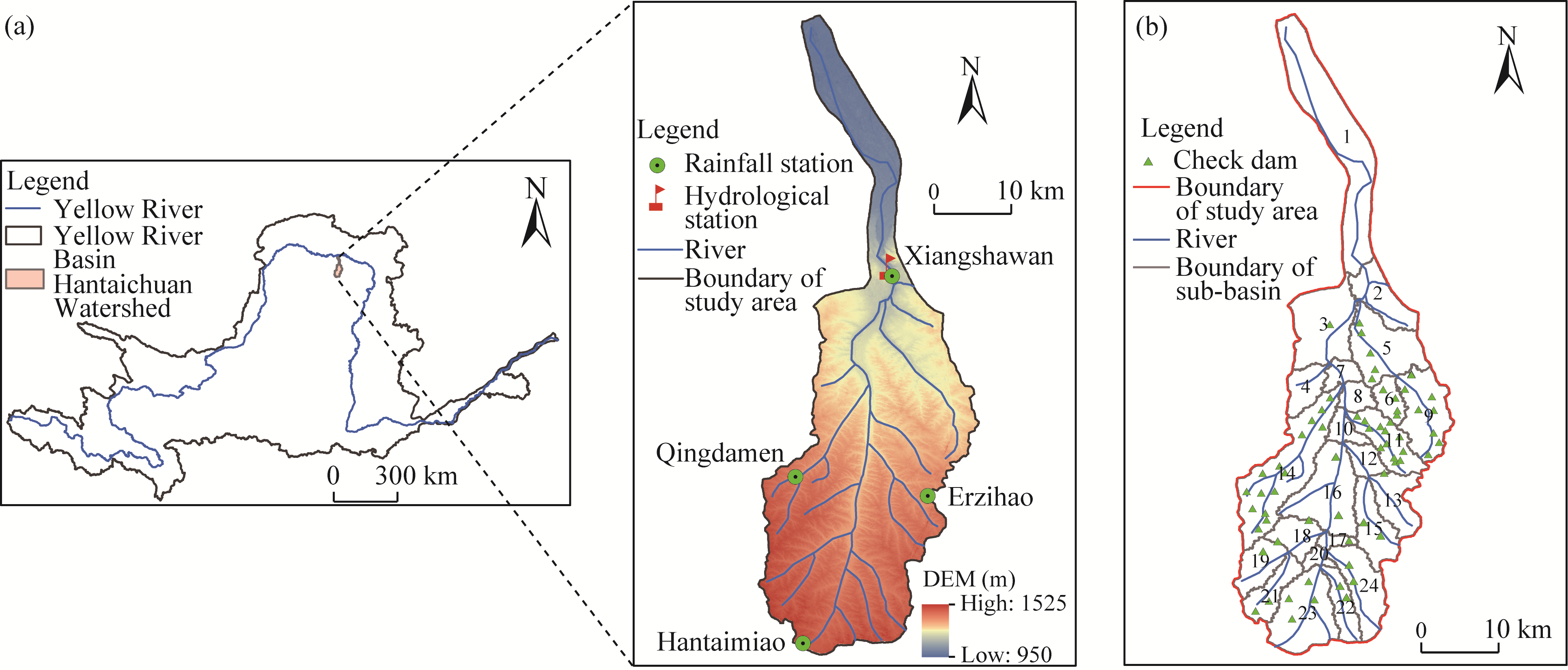
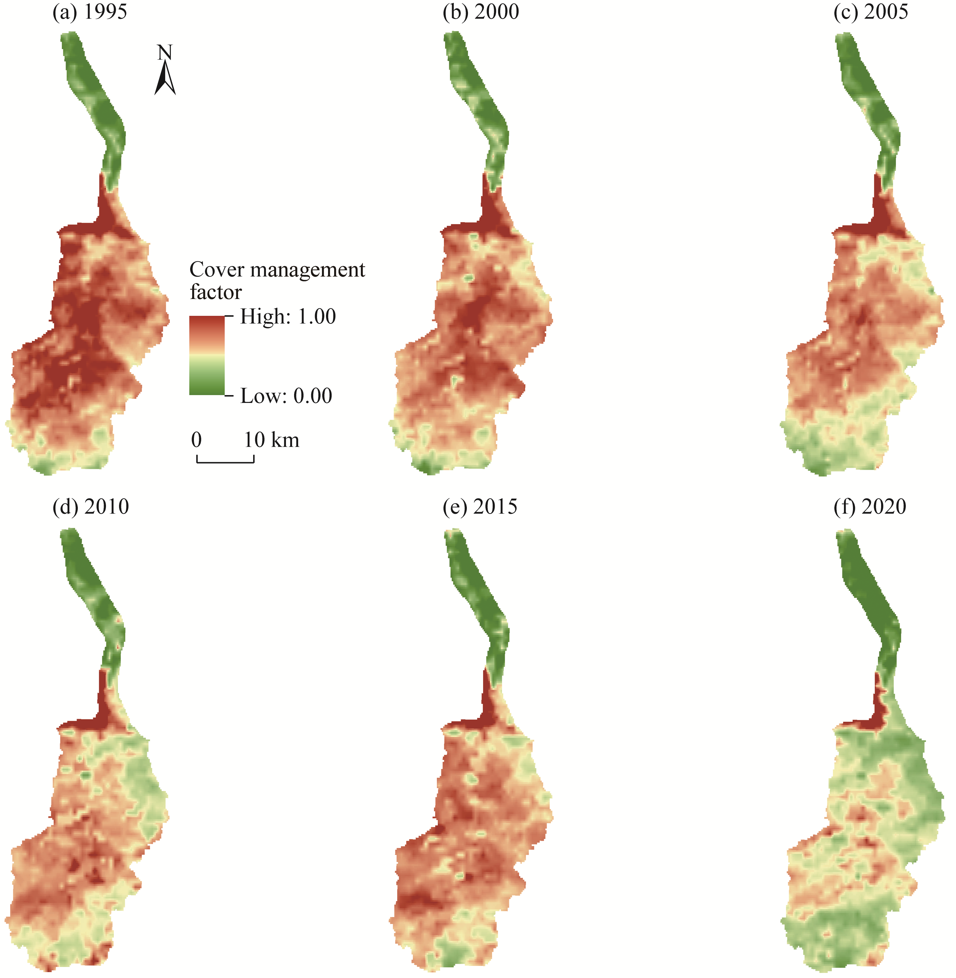
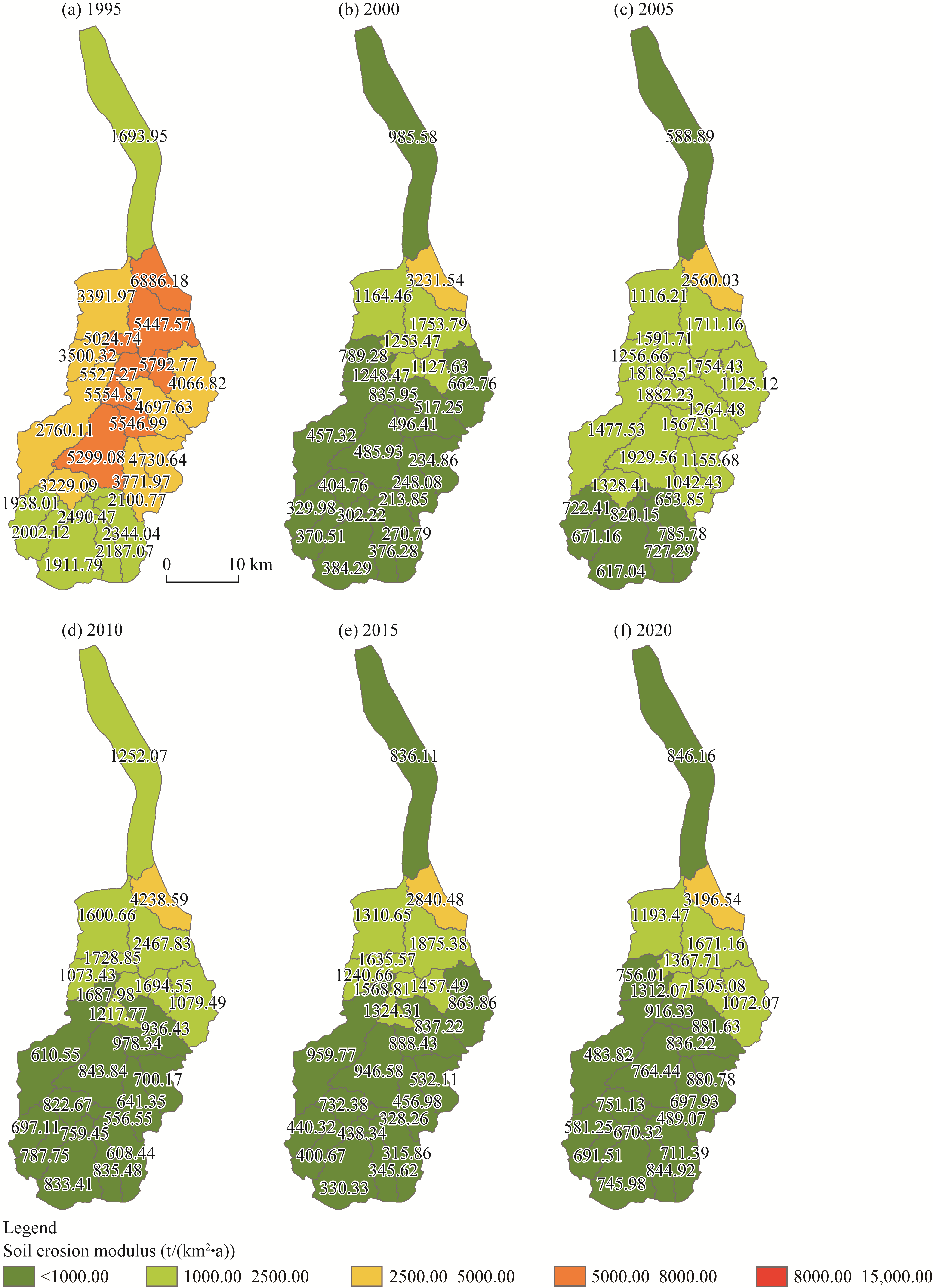
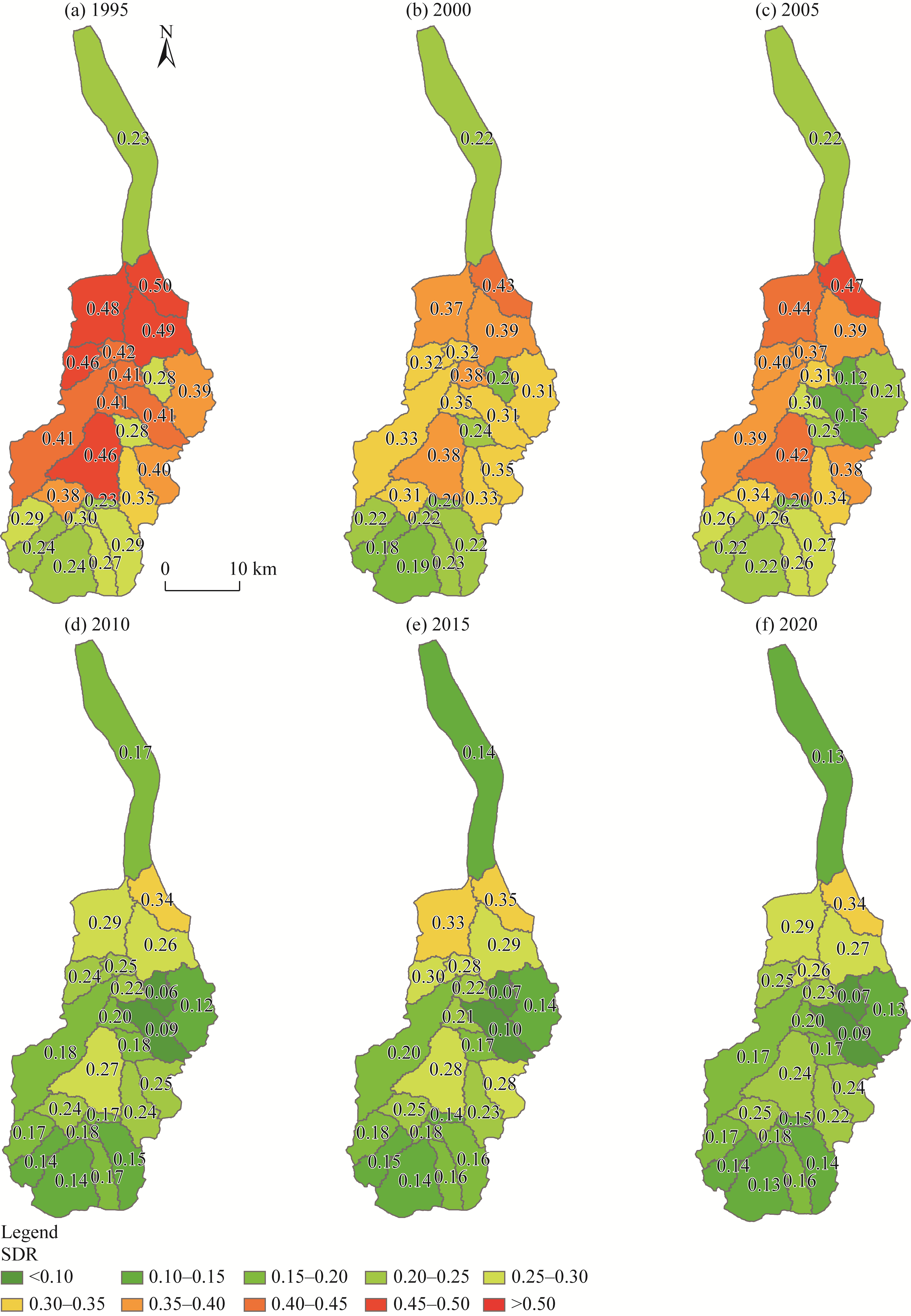
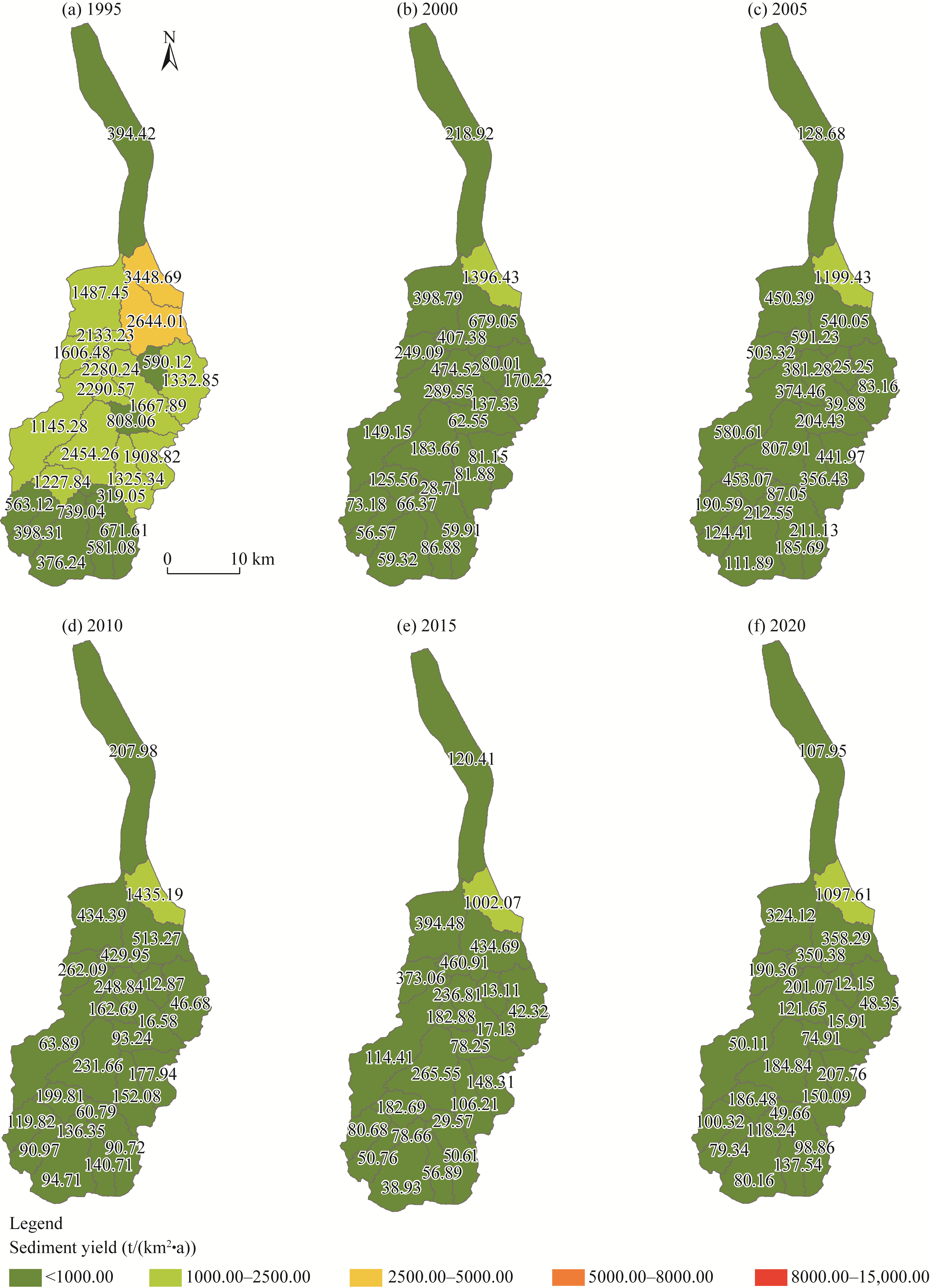
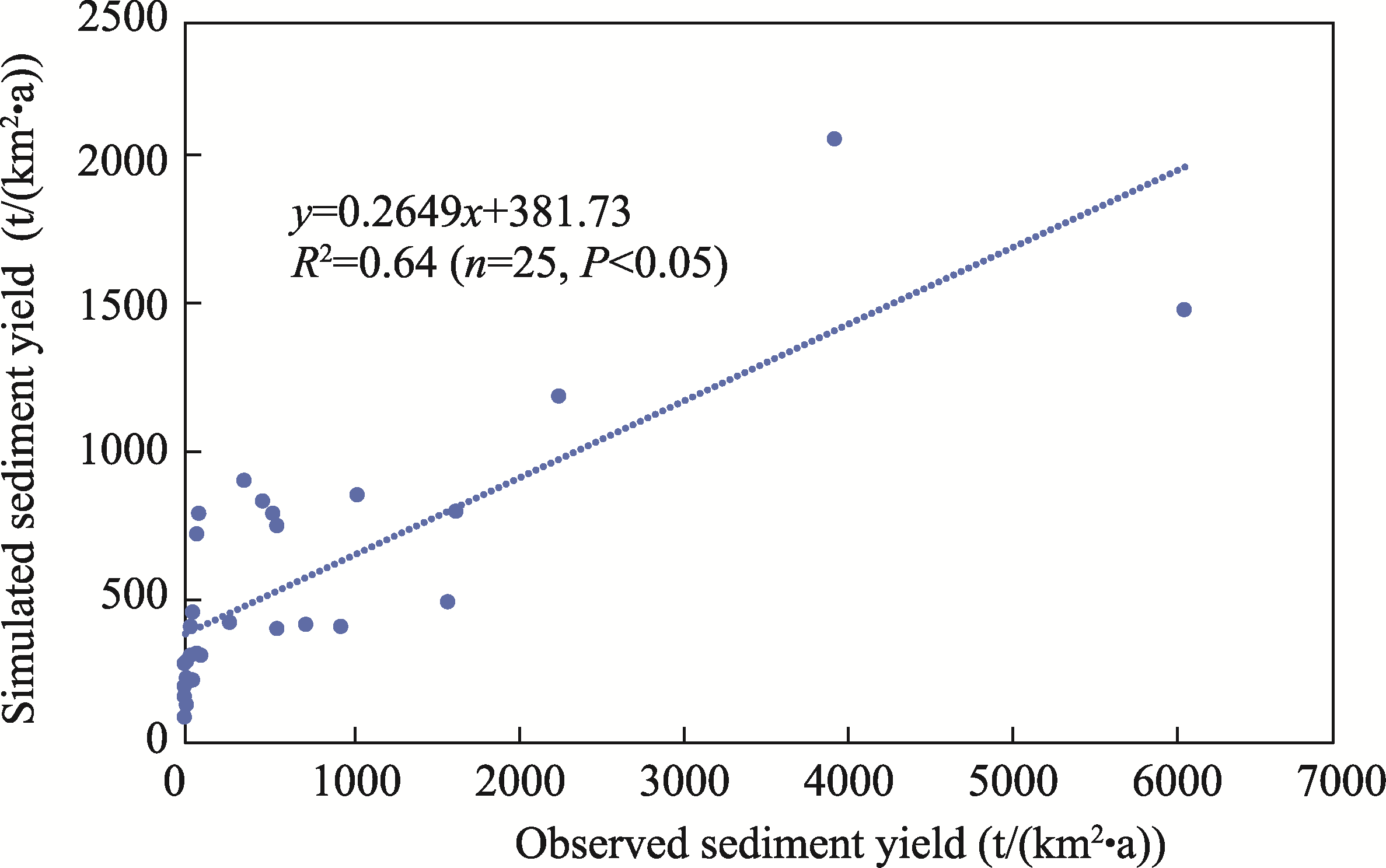
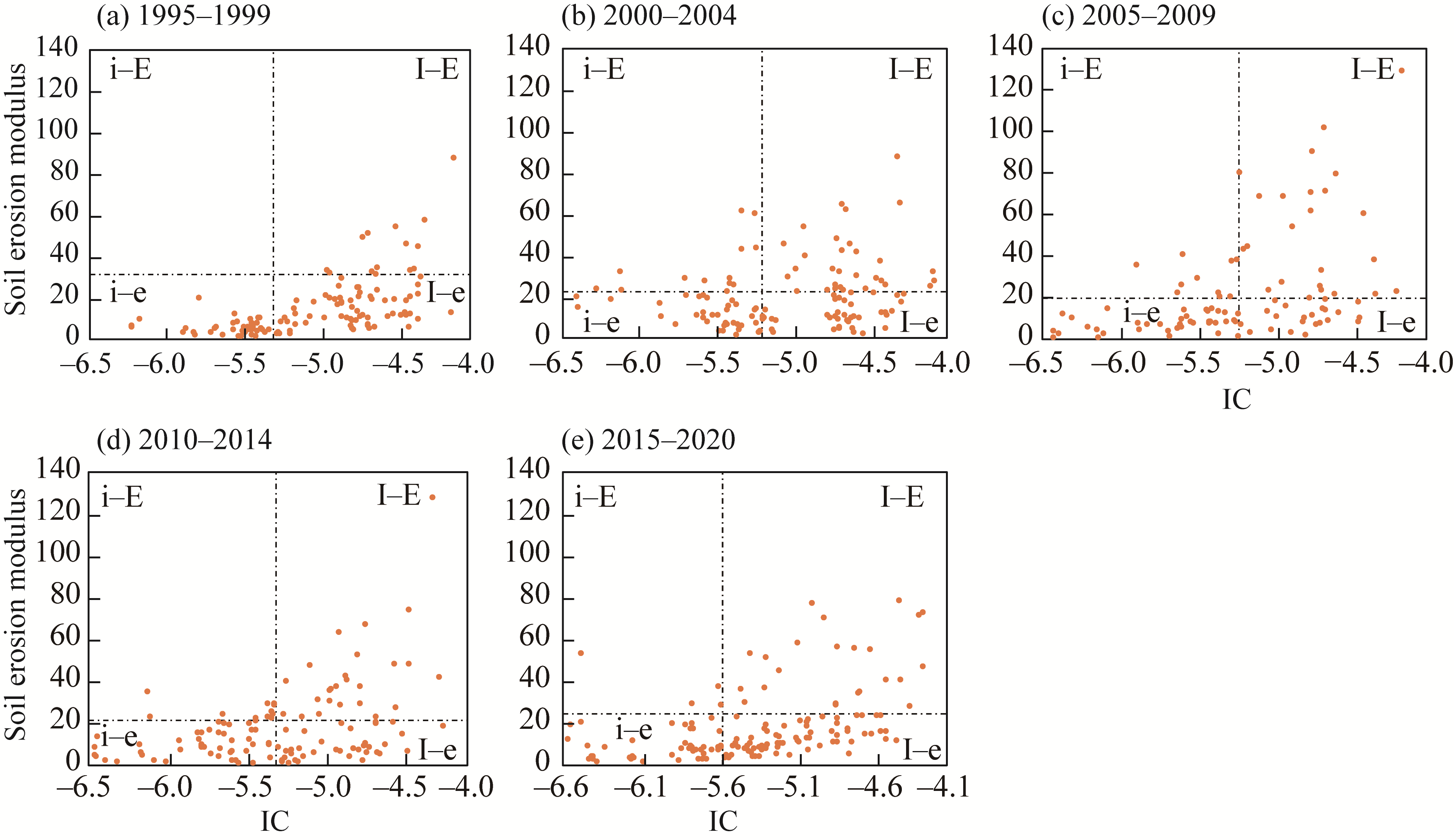
Abstract Over the past six decades, the implementation of soil and water conservation measures has significantly reduced soil erosion and sediment yield on the Loess Plateau, China. However, while the overall reduction is well-documented, the dynamic interplay between soil erosion potential and sediment connectivity, specifically how they spatially covary under land use/cover changes, remains insufficiently understood. To address this gap, this study established a model framework by integrating the revised universal soil loss equation (RUSLE), index of connectivity (IC), and sediment delivery ratio (SDR) to evaluate the spatio-temporal variations in soil erosion and sediment yield in the Hantaichuan Watershed, northern Loess Plateau, China, from 1995 to 2020 and to estimate the effects of land use/cover changes and check dam construction on sediment yield. The results revealed that the soil erosion in the Hantaichuan Watershed decreased by 43.90% from 1995 to 2020 and the sediment yield decreased by 69.28% under the combination of land use/cover changes and check dam construction. The IC and soil erosion (IC-SE) map revealed both the coupling and decoupling covariation relationships between sediment connectivity and soil erosion. By 2020, areas with high connectivity and high erosion (I-E) covered only 18.67% of the watershed, while contributed more than 40.00% to the total erosion. The I-E zones were mainly located in the central part of the watershed where aeolian sands derived from the Hobq Desert are concentrated and were identified as critical areas for soil and water conservation. This study provides support for priority management of watershed conservation measures as well as a valuable reference for future studies.
|
|
Received: 02 July 2025
Published: 31 December 2025
|
|
Corresponding Authors:
*ZHAO Guangju (E-mail: gjzhao@nhri.cn)
|
| Cite this article:
SHAN Rui, TIAN Peng, LU Ang, FAN Junjian, GUO Xiaoxue, ZHAO Yanbo, MU Xingmin, ZHAO Guangju. Soil erosion and sediment connectivity variations in the Hantaichuan Watershed, northern Loess Plateau, China from 1995 to 2020. Journal of Arid Land, 2025, 17(12): 1761-1784.
URL:
http://jal.xjegi.com/10.1007/s40333-025-0114-7 OR http://jal.xjegi.com/Y2025/V17/I12/1761
|
|
|
| [1] |
Abebe N, Eekhout J, Vermeulen B, et al. 2023. The potential and challenges of the 'RUSLE-IC-SDR' approach to identify sediment dynamics in a Mediterranean catchment. CATENA, 233: 107480, doi:10.1016/j.catena.2023.107480.
|
|
|
| [2] |
Appels W M, Bogaart P W,van der Zee S E A T M. 2016. Surface runoff in flat terrain: How field topography and runoff generating processes control hydrological connectivity. Journal of Hydrology, 534: 493-504.
doi: 10.1016/j.jhydrol.2016.01.021
|
|
|
| [3] |
Arnold J G, Srinivasan R, Muttiah J R, et al. 1998. Large area hydrologic modeling and assessment Part 1: model development. Journal of the American Water Resources Association, 34(1): 73-89.
doi: 10.1111/jawr.1998.34.issue-1
|
|
|
| [4] |
Baartman J E M, Masselink R, Keesstra S D, et al. 2013. Linking landscape morphological complexity and sediment connectivity. Earth Surface Processes and Landforms, 38(12): 1457-1471.
doi: 10.1002/esp.v38.12
|
|
|
| [5] |
Bai L L, Shi P, Wang W, et al. 2023. Sediment sources and their impacts on a check dam-controlled watershed, Loess Plateau, China. Journal of Mountain Science, 20: 1660-1673.
doi: 10.1007/s11629-022-7888-2
|
|
|
| [6] |
Bao Y T. 2024. An analysis of land-use change and driving force in Ordos. Geographical Science Research, 13(1): 82156, doi:10.12677/GSER.2024.131023. (in Chinese)
|
|
|
| [7] |
Bhattacharya R K, Das Chatterjee N, Das K. 2024. Modelling of soil erosion susceptibility incorporating sediment connectivity and export at landscape scale using integrated machine learning, InVEST-SDR and Fragstats. Journal of Environmental Management, 353: 120164, doi:10.1016/j.jenvman.2024.120164.
|
|
|
| [8] |
Borselli L, Cassi P, Torri D. 2008. Prolegomena to sediment and flow connectivity in the landscape: A GIS and field numerical assessment. CATENA, 75(3): 268-277.
doi: 10.1016/j.catena.2008.07.006
|
|
|
| [9] |
Bracken L J, Croke J. 2007. The concept of hydrological connectivity and its contribution to understanding runoff-dominated geomorphic systems. Hydrological Processes, 21(13): 1749-1763.
doi: 10.1002/hyp.v21:13
|
|
|
| [10] |
Brune G M. 1953. Trap efficiency of reservoirs. Eos, Transactions American Geophysical Union, 34(3): 407-418.
doi: 10.1029/TR034i003p00407
|
|
|
| [11] |
Cai C F, Ding S W, Shi Z H, et al. 2000. Study of applying USLE and geographical information system IDRISI to predict soil erosion in small watershed. Journal of Soil and Water Conservation, 14(2): 19-24. (in Chinese)
|
|
|
| [12] |
Cavalli M, Trevisani S, Comiti F, et al. 2013. Geomorphometric assessment of spatial sediment connectivity in small Alpine catchments. Geomorphology, 188: 31-41.
doi: 10.1016/j.geomorph.2012.05.007
|
|
|
| [13] |
Cavalli M, Vericat D, Pereira P. 2019. Mapping water and sediment connectivity. Science of the Total Environment, 673: 763-767.
doi: 10.1016/j.scitotenv.2019.04.071
|
|
|
| [14] |
Chen J, Li Z W, Xiao H B, et al. 2021. Effects of land use and land cover on soil erosion control in southern China: Implications from a systematic quantitative review. Journal of Environmental Management, 282: 111924, doi:10.1016/j.jenvman.2020.111924.
|
|
|
| [15] |
Dash S S, Maity R. 2023. Effect of climate change on soil erosion indicates a dominance of rainfall over LULC changes. Journal of Hydrology: Regional Studies, 47: 101373, doi:10.1016/j.ejrh.2023.101373.
|
|
|
| [16] |
Diodato N, Grauso S. 2009. An improved correlation model for sediment delivery ratio assessment. Environmental Earth Sciences, 59: 223-231.
doi: 10.1007/s12665-009-0020-x
|
|
|
| [17] |
Fan S H, Qin F C, Che Z H. 2024. Geochemical indicators to constrain weathering, provenance and tectonic setting of the Pisha Sandstone (Early-Middle Triassic) in Northeast Ordos Basin, China. Heliyon, 10(8): e29120, doi:10.1016/j.heliyon.2024.e29120.
|
|
|
| [18] |
Ferreira C S S, Kašanin-Grubin M, Kapović Solomun M, et al. 2024. Chapter 13 - Impacts of land use and land cover changes on soil erosion. In: Melesse A M, Rahmati O, Khosravi K, et al. Modeling. Remote Sensing of Soil and Land Surface Processes. Monitoring, Mapping, and Amsterdam: Elsevier, 229-248.
|
|
|
| [19] |
Fu B J, Liu Y, Lü Y H, et al. 2011. Assessing the soil erosion control service of ecosystems change in the Loess Plateau of China. Ecological Complexity, 8(4): 284-293.
doi: 10.1016/j.ecocom.2011.07.003
|
|
|
| [20] |
Ganasri B P, Ramesh H. 2016. Assessment of soil erosion by RUSLE model using remote sensing and GIS—A case study of Nethravathi Basin. Geoscience Frontiers, 7(6): 953-961.
doi: 10.1016/j.gsf.2015.10.007
|
|
|
| [21] |
Gu C J, Zhu Y Q, Li R H, et al. 2021. Effects of different soil and water conservation measures on hydrological extremes and flood processes in the Yanhe River, Loess Plateau, China. Natural Hazards, 109: 545-566.
doi: 10.1007/s11069-021-04848-w
|
|
|
| [22] |
Guo S S, Zhu Z R, Lü L. 2018. Effects of climate change and human activities on soil erosion in the Xihe River Basin, China. Water, 10(8): 1085, doi:10.3390/w10081085.
|
|
|
| [23] |
Guo Z J, Wu L, Liu S, et al. 2023. An integrated watershed modeling framework to explore the covariation between sediment connectivity and soil erosion. European Journal of Soil Science, 74(5): 13412, doi:10.1111/ejss.13412.
|
|
|
| [24] |
Hamel P, Falinski K, Sharp R, et al. 2017. Sediment delivery modeling in practice: Comparing the effects of watershed characteristics and data resolution across hydroclimatic regions. Science of the Total Environment, 580: 1381-1388.
doi: 10.1016/j.scitotenv.2016.12.103
|
|
|
| [25] |
Hao R, Huang X, Cai Z W, et al. 2022. Incorporating sediment connectivity index into MUSLE model to explore soil erosion and sediment yield relationships at event scale. Journal of Hydrology, 614: 128579, doi:10.1016/j.jhydrol.2022.128579.
|
|
|
| [26] |
Jain M K, Kothyari U C. 2000. Estimation of soil erosion and sediment yield using GIS. Hydrological Sciences Journal, 45(5): 771-786.
doi: 10.1080/02626660009492376
|
|
|
| [27] |
Jenks G F. 1967. The data model concept in statistical mapping. In:International Yearbook of Cartography. Gutersloh: C. Bertelsman Verlag, 186-190.
|
|
|
| [28] |
Le Bissonnais Y, Lecomte V, Cerdan O. 2004. Grass strip effects on runoff and soil loss. Agronomy for Sustainable Development, 24(3): 129-136.
|
|
|
| [29] |
Li E H, Mu X M, Zhao G J, et al. 2017. Effects of check dams on runoff and sediment load in a semi-arid river basin of the Yellow River. Stochastic Environmental Research and Risk Assessment, 31: 1791-1803.
doi: 10.1007/s00477-016-1333-4
|
|
|
| [30] |
Li J L, Sun R H, Xiong M Q, et al. 2020. Estimation of soil erosion based on the RUSLE model in China. Acta Ecologica Sinica, 40(10): 3473-3485. (in Chinese)
|
|
|
| [31] |
Liu C X, Chen Y N, Fang G H, et al. 2024. Impact of climatic and geomorphologic drivers on sediment connectivity in the Tarim River Basin, China. Journal of Hydrology, 643: 132027, doi:10.1016/j.jhydrol.2024.132027.
|
|
|
| [32] |
Liu S. 2024. Analysis of factors affecting sediment connectivity and simulation of sediment production in the Jinghe River Basin. MSc Thesis. Yangling: Northwest A&F University. (in Chinese)
|
|
|
| [33] |
Liu W, Shi C X, Ma Y Y, et al. 2021. Land use and land cover change-induced changes of sediment connectivity and their effects on sediment yield in a catchment on the Loess Plateau in China. CATENA, 207: 105688, doi:10.1016/j.catena.2021.105688.
|
|
|
| [34] |
Liu W, Shi C X, Ma Y Y, et al. 2022. Evaluating sediment connectivity and its effects on sediment reduction in a catchment on the Loess Plateau, China. Geoderma, 408: 115566, doi:10.1016/j.geoderma.2021.115566.
|
|
|
| [35] |
Liu X R, Feng T J, Zhang Y F, et al. 2025. Vegetation restoration affects soil hydrological processes in typical natural and planted forests on the Loess Plateau. Journal of Hydrology, 650: 132465, doi:10.1016/j.jhydrol.2024.132465.
|
|
|
| [36] |
Liu Z T. 2023. Runoff and sediment changes and their responses to precipitation and land use change in Hantaichuan Watershed. MSc Thesis. Hohot: Inner Mongolia Agricultural University. (in Chinese)
|
|
|
| [37] |
López-Vicente M, Poesen J, Navas A, et al. 2013. Predicting runoff and sediment connectivity and soil erosion by water for different land use scenarios in the Spanish Pre-Pyrenees. CATENA, 102: 62-73.
doi: 10.1016/j.catena.2011.01.001
|
|
|
| [38] |
Luo D. 2022. Eco-hydrological effects of different vegetation restoration catchments in the gully region of Loess Plateau. PhD Dissertation. Xi'an: Institute of Earth Environment, Chinese Academy of Sciences. (in Chinese)
|
|
|
| [39] |
Michalek A, Zarnaghsh A, Husic A. 2021. Modeling linkages between erosion and connectivity in an urbanizing landscape. Science of the Total Environment, 764: 144255, doi:10.1016/j.scitotenv.2020.144255.
|
|
|
| [40] |
Millares-Valenzuela A, Eekhout J P C, Martínez-Salvador A, et al. 2022. Evaluation of sediment connectivity through physically-based erosion modeling of landscape factor at the event scale. CATENA, 213: 106165, doi:10.1016/j.catena.2022.106165.
|
|
|
| [41] |
Min J, Liu X H, Li H Y, et al. 2024. Spatio-temporal variations in soil erosion and its driving forces in the Loess Plateau from 2000 to 2050 based on the RUSLE model. Applied Sciences, 14(13): 5945, doi:10.3390/app14135945.
|
|
|
| [42] |
Ministry of Water Resources of the People's Republic of China. 1995-2020. Hydrological Yearbook of the People's Republic of China:Hydrological Data of the Yellow River Basin. Beijing: China Water & Hydropower Press. (in Chinese)
|
|
|
| [43] |
Ministry of Water Resources of the People's Republic of China. 2008 Standard for Classification and Gradation of Soil Erosion (SL 190-2007). [2025-05-04]. https://www.mwr.gov.cn/. (in Chinese)
|
|
|
| [44] |
Moisa M B, Negash D A, Merga B B, et al. 2021. Impact of land-use and land-cover change on soil erosion using the RUSLE model and the geographic information system: a case of Temeji Watershed, western Ethiopia. Journal of Water and Climate Change, 12(7): 3404-3420.
doi: 10.2166/wcc.2021.131
|
|
|
| [45] |
Najafi S, Dragovich D, Heckmann T, et al. 2021. Sediment connectivity concepts and approaches. CATENA, 196: 104880, doi:10.1016/j.catena.2020.104880.
|
|
|
| [46] |
Persichillo M G, Bordoni M, Cavalli M, et al. 2018. The role of human activities on sediment connectivity of shallow landslides. CATENA, 160: 261-274.
doi: 10.1016/j.catena.2017.09.025
|
|
|
| [47] |
Pinzon J E, Pak E W, Tucker C J, et al. 2023. Global Vegetation Greenness (NDVI) from AVHRR GIMMS-3G+, 1981-2022. [2025-05-23]. https://www.earthdata.nasa.gov/data/catalog/ornl-cloud-global-veg-greenness-gimms-3g-2187-1#overview=.
|
|
|
| [48] |
Pollen-Bankhead N, Simon A. 2010. Hydrologic and hydraulic effects of riparian root networks on streambank stability: Is mechanical root-reinforcement the whole story? Geomorphology, 116(3-4): 353-362.
doi: 10.1016/j.geomorph.2009.11.013
|
|
|
| [49] |
Renard K G, Foster G R, Weesies G A, et al. 1997. Predicting soil erosion by water:A guide to conservation planning with the Revised Universal Soil Loss Equation (RUSLE). In:The United States Department of Agriculture (USDA) Agriculture Handbook No. 703. Washington D.C.: USDA,45-65.
|
|
|
| [50] |
Sandercock P J, Hooke J M. 2011. Vegetation effects on sediment connectivity and processes in an ephemeral channel in SE Spain. Journal of Arid Environments, 75(3): 239-254.
doi: 10.1016/j.jaridenv.2010.10.005
|
|
|
| [51] |
Sheng F, Yi T X, Wang Y Y, et al. 2025. Changes in sediment connectivity and its impact on sediment transport in a typical watershed of southern Jiangxi Province, China. Ecological Indicators, 171: 113204, doi:10.1016/j.ecolind.2025.113204.
|
|
|
| [52] |
Shi P, Zhang Y, Ren Z Q, et al. 2019. Land-use changes and check dams reducing runoff and sediment yield on the Loess Plateau of China. Science of the Total Environment, 664: 984-994.
doi: 10.1016/j.scitotenv.2019.01.430
|
|
|
| [53] |
Stephens C M, Lall U, Johnson F M, et al. 2021. Landscape changes and their hydrologic effects: Interactions and feedbacks across scales. Earth-Science Reviews, 212: 103466, doi:10.1016/j.earscirev.2020.103466.
|
|
|
| [54] |
Sun W Y, Shao Q Q, Liu J Y, et al. 2014. Assessing the effects of land use and topography on soil erosion on the Loess Plateau in China. CATENA, 121: 151-163.
doi: 10.1016/j.catena.2014.05.009
|
|
|
| [55] |
Tang C J, Liu Y, Li Z W, et al. 2021. Effectiveness of vegetation cover pattern on regulating soil erosion and runoff generation in red soil environment, southern China. Ecological Indicators, 129: 107956, doi:10.1016/j.ecolind.2021.107956.
|
|
|
| [56] |
Thapa P. 2020. Spatial estimation of soil erosion using RUSLE modeling: a case study of Dolakha District, Nepal. Environmental Systems Research, 9: 15, doi:10.21203/rs.3.rs-25478/v4.
|
|
|
| [57] |
Vigiak O, Borselli L, Newham L T H, et al. 2012. Comparison of conceptual landscape metrics to define hillslope-scale sediment delivery ratio. Geomorphology, 138(1): 74-88.
doi: 10.1016/j.geomorph.2011.08.026
|
|
|
| [58] |
Vigiak O, Beverly C, Roberts A, et al. 2016. Detecting changes in sediment sources in drought periods: The Latrobe River case study. Environmental Modelling & Software, 85: 42-55.
|
|
|
| [59] |
Wang J H, Zhang R G, Sun J. 2018. Experimental study on influence of vegetation coverage on runoff in wind-water erosion crisscross region. Earth and Environmental Science, 121(12): 022021, doi:10.1088/1755-1315/121/2/022021.
|
|
|
| [60] |
Wischmeier W H, Smith D D. 1978. Predicting rainfall erosion losses:a guide to conservation planning. In: USDA Agriculture Handbook No.537. Washington D. C.: USDA.
|
|
|
| [61] |
Woznicki S A, Cada P, Wickham J, et al. 2020. Sediment retention by natural landscapes in the conterminous United States. Science of the Total Environment, 745(25): 140972, doi:10.1016/j.scitotenv.2020.140972.
|
|
|
| [62] |
Wuepper D, Borrelli P, Finger R. 2020. Countries and the global rate of soil erosion. Nature Sustainability, 3: 51-55.
doi: 10.1038/s41893-019-0438-4
|
|
|
| [63] |
Yang H, Shi C X. 2018. Spatial and temporal variations of aeolian sediment input to the tributaries (the Ten Kongduis) of the upper Yellow River. Aeolian Research, 30: 1-10.
doi: 10.1016/j.aeolia.2017.10.002
|
|
|
| [64] |
Yang K, Zhang J T, Cui D G, et al. 2025. Multi-scale study of the synergy between human activities and climate change on urban heat islands in China. Sustainable Cities and Society, 125: 106341, doi:10.1016/j.scs.2025.106341.
|
|
|
| [65] |
Zanandrea F, Michel G P, Kobiyama M, et al. 2019. Evaluation of different DTMs in sediment connectivity determination in the Mascarada River Watershed, southern Brazil. Geomorphology, 332: 80-87.
doi: 10.1016/j.geomorph.2019.02.005
|
|
|
| [66] |
Zanandrea F, Michel G P, Kobiyama M, et al. 2021. Spatial-temporal assessment of water and sediment connectivity through a modified connectivity index in a subtropical mountainous catchment. CATENA, 204: 105380, doi:10.1016/j.catena.2021.105380.
|
|
|
| [67] |
Zeng W Y, Tian Y S, Zhai J, et al. 2025. Soil erosion resilience under climate extremes: Disentangling the impacts of vegetation restoration and rainfall intensification across China. Ecological Indicators, 178: 113994, doi:10.1016/j.ecolind.2025.113994.
|
|
|
| [68] |
Zeng Y, Meng X D, Wang B, et al. 2023. Effects of soil and water conservation measures on sediment delivery processes in a hilly and gully watershed. Journal of Hydrology, 616: 128804, doi:10.1016/j.jhydrol.2022.128804.
|
|
|
| [69] |
Zhang T, Peng J, Liang W, et al. 2016. Spatial-temporal patterns of water use efficiency and climate controls in China's Loess Plateau during 2000-2010. Science of the Total Environment, 565: 105-122.
doi: 10.1016/j.scitotenv.2016.04.126
|
|
|
| [70] |
Zhang W B, Fu J S. 2003. Rainfall erosivity estimation under different rainfall amount. Resources Science, 25(1): 35-41. (in Chinese)
|
|
|
| [71] |
Zhang Y F. 2019. Response of channel sediment connectivity to channel morphology and rainfall in small watershed of the hill and gully Loess Plateau region. MSc Thesis. Yangling: Northwest A&F University. (in Chinese)
|
|
|
| [72] |
Zhang Y J. 2024. Study on the spatial-temporal evolution and potential risks of soil erosion in the Xiliugou Watershed of the Shi Da Kong Dui. MSc Thesis. Yangling: Northwest A&F University. (in Chinese)
|
|
|
| [73] |
Zhao G J, Kondolf G M, Mu X M, et al. 2017. Sediment yield reduction associated with land use changes and check dams in a catchment of the Loess Plateau, China. CATENA, 148: 126-137.
doi: 10.1016/j.catena.2016.05.010
|
|
|
| [74] |
Zhao G J, Gao P, Tian P, et al. 2020. Assessing sediment connectivity and soil erosion by water in a representative catchment on the Loess Plateau, China. CATENA, 185: 104284, doi:10.1016/j.catena.2019.104284.
|
|
|
| [75] |
Zhao J T. 2023. Response of soil erosion and water and sediment to land use change in the Hantaichuan Basin. MSc Thesis. Yangling: Northwest A&F University. (in Chinese)
|
|
|
| [76] |
Zuo D P, Xu Z X, Yao W Y, et al. 2016. Assessing the effects of changes in land use and climate on runoff and sediment yields from a watershed in the Loess Plateau of China. Science of the Total Environment, 544: 238-250.
doi: 10.1016/j.scitotenv.2015.11.060
|
|
|
|
Viewed |
|
|
|
Full text
|
|
|
|
|
Abstract
|
|
|
|
|
Cited |
|
|
|
|
| |
Shared |
|
|
|
|
| |
Discussed |
|
|
|
|