| Research article |
|


|
|
|
| Check dam extraction from remote sensing images using deep learning and geospatial analysis: A case study in the Yanhe River Basin of the Loess Plateau, China |
SUN Liquan1,2,3, GUO Huili1,2, CHEN Ziyu4, YIN Ziming4, FENG Hao1,2, WU Shufang1,2,3,*( ), Kadambot H M SIDDIQUE5 ), Kadambot H M SIDDIQUE5 |
1Key Laboratory of Agricultural Soil and Water Engineering in Arid and Semiarid Areas, Ministry of Education, Northwest A&F University, Yangling 712100, China
2Institute of Water-Saving Agriculture in Arid Areas of China, Northwest A&F University, Yangling 712100, China
3College of Water Resources and Architectural Engineering, Northwest A&F University, Yangling 712100, China
4College of Natural Resources and Environment, Northwest A&F University, Yangling 712100, China
5The UWA Institute of Agriculture and School of Agriculture & Environment, The University of Western Australia, Perth 6001, Australia |
|
|
|
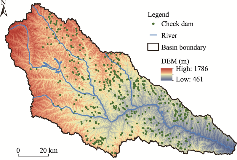
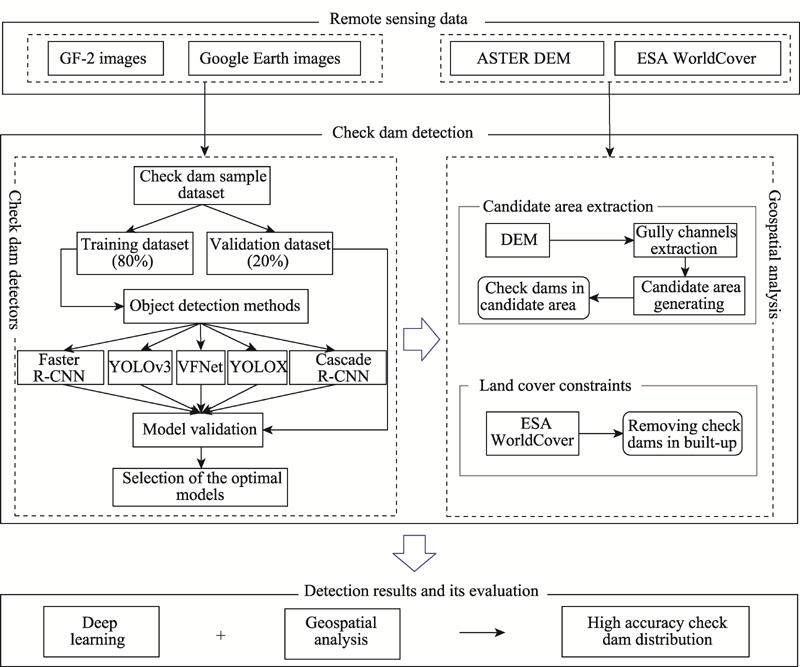
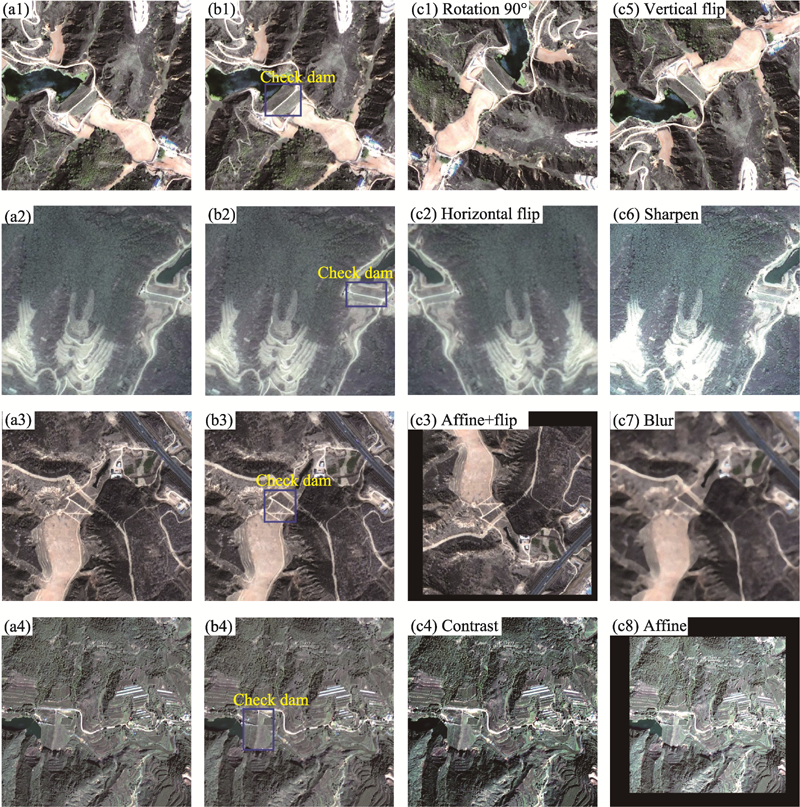
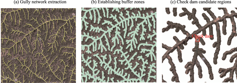
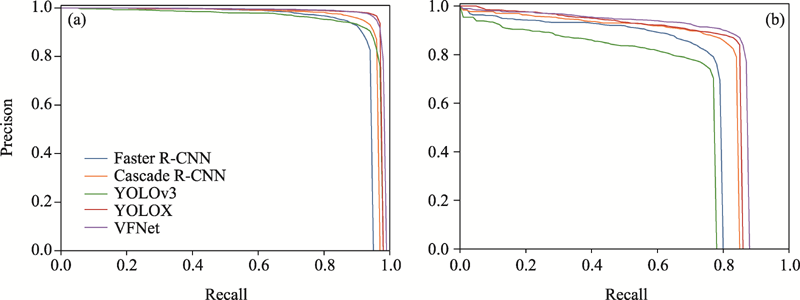
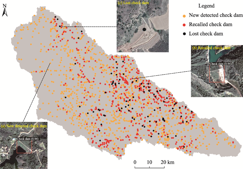
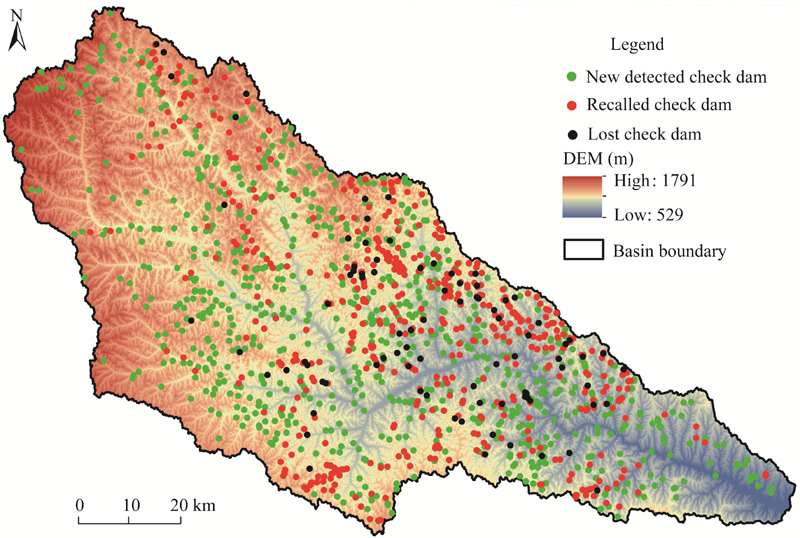
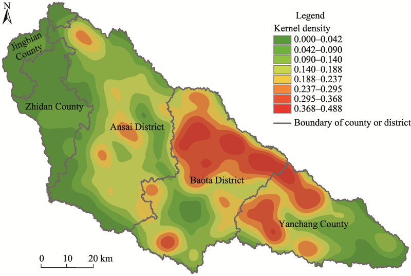
Abstract Check dams are widely used on the Loess Plateau in China to control soil and water losses, develop agricultural land, and improve watershed ecology. Detailed information on the number and spatial distribution of check dams is critical for quantitatively evaluating hydrological and ecological effects and planning the construction of new dams. Thus, this study developed a check dam detection framework for broad areas from high-resolution remote sensing images using an ensemble approach of deep learning and geospatial analysis. First, we made a sample dataset of check dams using GaoFen-2 (GF-2) and Google Earth images. Next, we evaluated five popular deep-learning-based object detectors, including Faster R-CNN, You Only Look Once (version 3) (YOLOv3), Cascade R-CNN, YOLOX, and VarifocalNet (VFNet), to identify the best one for check dam detection. Finally, we analyzed the location characteristics of the check dams and used geographical constraints to optimize the detection results. Precision, recall, average precision at intersection over union (IoU) threshold of 0.50 (AP50), IoU threshold of 0.75 (AP75), and average value for 10 IoU thresholds ranging from 0.50-0.95 with a 0.05 step (AP50-95), and inference time were used to evaluate model performance. All the five deep learning networks could identify check dams quickly and accurately, with AP50-95, AP50, and AP75 values higher than 60.0%, 90.0%, and 70.0%, respectively, except for YOLOv3. The VFNet had the best performance, followed by YOLOX. The proposed framework was tested in the Yanhe River Basin and yielded promising results, with a recall rate of 87.0% for 521 check dams. Furthermore, the geographic analysis deleted about 50% of the false detection boxes, increasing the identification accuracy of check dams from 78.6% to 87.6%. Simultaneously, this framework recognized 568 recently constructed check dams and small check dams not recorded in the known check dam survey datasets. The extraction results will support efficient watershed management and guide future studies on soil erosion in the Loess Plateau.
|
|
Received: 01 September 2022
Published: 31 January 2023
|
|
Corresponding Authors:
*WU Shufang (E-mail: wsfjs@163.com)
|
|
|
| [1] |
Abbasi N A, Xu X Z, Lucas-Borja M E, et al. 2019. The use of check dams in watershed management projects: Examples from around the world. Science of the Total Environment, 676: 683-691.
doi: 10.1016/j.scitotenv.2019.04.249
|
|
|
| [2] |
Alfonso-Torreño A, Gómez-Gutiérrez Á, Schnabel S, et al. 2019. sUAS, SfM-MVS photogrammetry and a topographic algorithm method to quantify the volume of sediments retained in check-dams. Science of the Total Environment, 678: 369-382.
doi: 10.1016/j.scitotenv.2019.04.332
|
|
|
| [3] |
Apolo-Apolo O E, Martínez-Guanter J, Egea G, et al. 2020. Deep learning techniques for estimation of the yield and size of citrus fruits using a UAV. European Journal of Agronomy, 115: 126030, doi: 10.1016/j.eja.2020.126030.
doi: 10.1016/j.eja.2020.126030
|
|
|
| [4] |
Bai L C, Wang N, Jiao J Y, et al. 2020. Soil erosion and sediment interception by check dams in a watershed for an extreme rainstorm on the Loess Plateau, China. International Journal of Sediment Research, 35(4): 408-416.
doi: 10.1016/j.ijsrc.2020.03.005
|
|
|
| [5] |
Bai M, Mo X G, Liu S X, et al. 2019. Contributions of climate change and vegetation greening to evapotranspiration trend in a typical hilly-gully basin on the Loess Plateau, China. Science of the Total Environment, 657: 325-339.
doi: 10.1016/j.scitotenv.2018.11.360
|
|
|
| [6] |
Cai Z W, Vasconcelos N. 2018. Cascade R-CNN: Delving into high quality object detection. In: Proceedings of the IEEE Conference on Computer Vision and Pattern Recognition (CVPR). Salt Lake City, USA.
|
|
|
| [7] |
Chen J Q, Zhang F. 2004. IKONOS secondary planet image data applied in a small watershed for soil and water conservation work. Bulletin of Soil and Water Conservation, 24(5): 64-66. (in Chinese)
|
|
|
| [8] |
Chen K, Wang J Q, Pang J M, et al. 2019. MMDetection: Open MMLab Detection Toolbox and Benchmark. [2022-06-20]. https://doi.org/10.48550/arXiv.1906.07155.
|
|
|
| [9] |
Chen Z, Zhang T, Ouyang C. 2018. End-to-End airplane detection using transfer learning in remote sensing images. Remote Sensing, 10(1): 139, doi: 10.3390/rs10010139.
doi: 10.3390/rs10010139
|
|
|
| [10] |
Ding P, Zhang Y, Deng W J, et al. 2018. A light and faster regional convolutional neural network for object detection in optical remote sensing images. ISPRS Journal of Photogrammetry and Remote Sensing, 141: 208-218.
doi: 10.1016/j.isprsjprs.2018.05.005
|
|
|
| [11] |
Fu K, Chen Z, Zhang Y, et al. 2019. Enhanced feature representation in detection for optical remote sensing images. Remote Sensing, 11(18): 2095, doi: 10.3390/rs11182095.
doi: 10.3390/rs11182095
|
|
|
| [12] |
Ge Z, Liu S T, Wang F, et al. 2021. YOLOX: Exceeding YOLO Series in 2021. [2022-06-20]. https://doi.org/10.48550/arXiv.2107.08430.
|
|
|
| [13] |
Ghanbari H, Mahdianpari M, Homayouni S, et al. 2021. A meta-analysis of convolutional neural networks for remote sensing applications. IEEE Journal of Selected Topics in Applied Earth Observations and Remote Sensing, 14: 3602-3613.
doi: 10.1109/JSTARS.2021.3065569
|
|
|
| [14] |
Hou Q Q. 2013. Soil conservation practices information extraction from remote sensing images using object-oriented method. MSc Thesis. Yangling: Northwest A&F University. (in Chinese)
|
|
|
| [15] |
Jin Z, Cui B L, Song Y, et al. 2012. How many check dams do we need to build on the Loess Plateau? Environmental Science & Technology, 46(16): 8527-8528.
doi: 10.1021/es302835r
|
|
|
| [16] |
Kamilaris A, Prenafeta-Boldu F X. 2018. Deep learning in agriculture: A survey. Computers and Electronics in Agriculture, 147: 70-90.
doi: 10.1016/j.compag.2018.02.016
|
|
|
| [17] |
Khelifi L, Mignotte M. 2020. Deep learning for change detection in remote sensing images: comprehensive review and meta-analysis. IEEE Access, 8: 126385-126400.
doi: 10.1109/ACCESS.2020.3008036
|
|
|
| [18] |
Konstantinidis D, Argyriou V, Stathaki T, et al. 2020. A modular CNN-based building detector for remote sensing images. Computer Networks, 168: 107034, doi: 10.1016/j.comnet.2019.107034.
doi: 10.1016/j.comnet.2019.107034
|
|
|
| [19] |
Laben C A, Brower B V. 2000. Process for Enhancing the Spatial Solution of Multispectral Imagery Using Pan-Sharpening. [2022-06-20]. https://www.freepatentsonline.com/6011875.html.
|
|
|
| [20] |
Li N, Cheng L, Huang L Y, et al. 2021. Framework for unknown airport detection in broad areas supported by deep learning and geographic analysis. IEEE Journal of Selected Topics in Applied Earth Observations and Remote Sensing, 14: 6328-6338.
doi: 10.1109/JSTARS.2021.3088911
|
|
|
| [21] |
Li S J, Xiong L Y, Hu G H, et al. 2021. Extracting check dam areas from high-resolution imagery based on the integration of object-based image analysis and deep learning. Land Degradation & Development, 32(7): 2303-2317.
doi: 10.1002/ldr.3908
|
|
|
| [22] |
Lin T Y, Maire M, Belongie S, et al. 2014. Microsoft Coco: Common Objects in Context. [2022-06-21]. https://doi.org/ 10.1007/978-3-319-10602-1_48.
|
|
|
| [23] |
Liu X Y, Gao Y F, Ma S B, et al. 2018. Sediment reduction of warping dams and its timeliness in the Loess Plateau. Journal of Hydraulic Engineering, 49(2): 145-155. (in Chinese)
|
|
|
| [24] |
Liu Z. 2013. The national census for soil erosion and dynamic analysis in China. International Soil and Water Conservation Research, 1(2): 12-18.
doi: 10.1016/S2095-6339(15)30035-6
|
|
|
| [25] |
Lucas-Borja M E, Piton G, Nichols M, et al. 2019. The use of check dams for soil restoration at watershed level: a century of history and perspectives. Science of the Total Environment, 692: 37-38.
doi: 10.1016/j.scitotenv.2019.07.248
|
|
|
| [26] |
Lucas-Borja M E, Piton G, Yu Y, et al. 2021. Check dams worldwide: Objectives, functions, effectiveness and undesired effects. CATENA, 204: 105390, doi: 10.1016/j.catena.2021.105390.
doi: 10.1016/j.catena.2021.105390
|
|
|
| [27] |
Mahdianpari M, Salehi B, Rezaee M, et al. 2018. Very deep convolutional neural networks for complex land cover mapping using multispectral remote sensing imagery. Remote Sensing, 10(7): 1119, doi: 10.3390/rs10071119.
doi: 10.3390/rs10071119
|
|
|
| [28] |
Mi Z J, Mu X M, Zhao G J. 2015. Extraction of check dam based on multi-sources data in the Huangfuchuan watershed. Arid Land Geography, 38(1): 52-59. (in Chinese)
|
|
|
| [29] |
Ministry of Water Resources of China. 2013. Bulletin of First National Census for Water. Beijing: China Water & Power Press. (in Chinese)
|
|
|
| [30] |
Mur A, Travé-Massuyès L, Chanthery E, et al. 2022. A neural algorithm for the detection and correction of anomalies: Application to the landing of an airplane. Sensors, 22(6): 2334, doi: 10.3390/s22062334.
doi: 10.3390/s22062334
|
|
|
| [31] |
Ngula Niipele J, Chen J P. 2019. The usefulness of ALOS-PALSAR DEM data for drainage extraction in semi-arid environments in the Iishana sub-basin. Journal of Hydrology: Regional Studies, 21: 57-67.
doi: 10.1016/j.ejrh.2018.11.003
|
|
|
| [32] |
Piton G, Recking A. 2017. Effects of check dams on bed-load transport and steep-slope stream morphodynamics. Geomorphology, 291: 94-105.
doi: 10.1016/j.geomorph.2016.03.001
|
|
|
| [33] |
Pourghasemi H R, Yousefi S, Sadhasivam N, et al. 2020. Assessing, mapping, and optimizing the locations of sediment control check dams construction. Science of the Total Environment, 739: 139954, doi: 10.1016/j.scitotenv.2020.139954.
doi: 10.1016/j.scitotenv.2020.139954
|
|
|
| [34] |
Rahmati O, Ghasemieh H, Samadi M, et al. 2020. TET: An automated tool for evaluating suitable check-dam sites based on sediment trapping efficiency. Journal of Cleaner Production, 266: 122051, doi: 10.1016/j.jclepro.2020.122051.
doi: 10.1016/j.jclepro.2020.122051
|
|
|
| [35] |
Reda K, Kedzierski M. 2020. Detection, classification and boundary regularization of buildings in satellite imagery using faster edge region convolutional neural networks. Remote Sensing, 12(14): 2240, doi: 10.3390/rs12142240.
doi: 10.3390/rs12142240
|
|
|
| [36] |
Redmon J, Farhadi A. 2018. Yolov3: An Incremental Improvement. [2022-06-22]. https://doi.org/10.48550/arXiv.1804.02767.
|
|
|
| [37] |
Ren S Q, He K M, Girshick R, et al. 2017. Faster R-CNN: Towards real-time object detection with region proposal networks. IEEE Transactions on Pattern Analysis and Machine Intelligence, 39(6): 1137-1149.
doi: 10.1109/TPAMI.2016.2577031
pmid: 27295650
|
|
|
| [38] |
Robichaud P R, Storrar K A, Wagenbrenner J W. 2019. Effectiveness of straw bale check dams at reducing post-fire sediment yields from steep ephemeral channels. Science of the Total Environment, 676: 721-731.
doi: 10.1016/j.scitotenv.2019.04.246
|
|
|
| [39] |
Sharma V, Mir R N. 2020. A comprehensive and systematic look up into deep learning based object detection techniques: A review. Computer Science Review, 38: 100301, doi: 10.1016/j.cosrev.2020.100301.
doi: 10.1016/j.cosrev.2020.100301
|
|
|
| [40] |
Shi P, Zhang Y, Ren Z P, et al. 2019. Land-use changes and check dams reducing runoff and sediment yield on the Loess Plateau of China. Science of the Total Environment, 664: 984-994.
doi: 10.1016/j.scitotenv.2019.01.430
|
|
|
| [41] |
Sun P C, Wu Y P. 2022. Dynamic Modeling Framework of Sediment Trapped by Check-dam Networks: A Case Study of a Typical Watershed on the Chinese Loess Plateau. [2022-06-23]. https://doi.org/10.1016/j.eng.2021.12.015.
|
|
|
| [42] |
Tian P, Zhao G J, Mu X M, et al. 2013. Check dam identification using multisource data and their effects on streamflow and sediment load in a Chinese Loess Plateau catchment. Journal of Applied Remote Sensing, 7: 073697, doi: 10.1117/1.JRS.7.073697.
doi: 10.1117/1.JRS.7.073697
|
|
|
| [43] |
Wang Y F, Fu B J, Chen L D, et al. 2011. Check dam in the Loess Plateau of China: Engineering for environmental services and food security. Environmental Science & Technology, 45(24): 10298-10299.
doi: 10.1021/es2038992
|
|
|
| [44] |
Wang Z Y, Chen Z Y, Yu S, et al. 2021. Erosion-control mechanism of sediment check dams on the Loess Plateau. International Journal of Sediment Research, 36(5): 668-677.
doi: 10.1016/j.ijsrc.2021.02.002
|
|
|
| [45] |
Wei Y H, He Z, Jiao J Y, et al. 2018. Variation in the sediment deposition behind check-dams under different soil erosion conditions on the Loess Plateau, China. Earth Surface Processes and Landforms, 43(9): 1899-1912.
doi: 10.1002/esp.4364
|
|
|
| [46] |
Wu W T, Liu H, Li L L, et al. 2021. Application of local fully Convolutional Neural Network combined with YOLO v5 algorithm in small target detection of remote sensing image. PLoS ONE, 16(10): e0259283, doi: 10.1371/journal.pone.0259283.
doi: 10.1371/journal.pone.0259283
|
|
|
| [47] |
Yazdi J, Sabbaghian Moghaddam M, Saghafian B. 2018. Optimal design of check dams in mountainous watersheds for flood mitigation. Water Resources Management, 32: 4793-4811.
doi: 10.1007/s11269-018-2084-4
|
|
|
| [48] |
Zanaga D, Van De Kerchove R, De Keersmaecker W, et al. 2021. ESA WorldCover 10 m 2020 v100. [2022-06-23]. https://viewer.esa-worldcover.org/worldcover.
|
|
|
| [49] |
Zeng F X, Cheng L, Li N, et al. 2019. A hierarchical airport detection method using spatial analysis and deep learning. Remote Sensing, 11(19): 2204, doi: 10.3390/rs11192204.
doi: 10.3390/rs11192204
|
|
|
| [50] |
Zhang H Y, Wang Y, Dayoub F, et al. 2021. VarifocalNet: An IoU-aware Dense Object Detector. [2022-06-22]. https://doi.org/10.48550/arXiv.2008.13367.
|
|
|
| [51] |
Zhang K, Qian Z, Yang Y, et al. 2022. Using street view images to identify road noise barriers with ensemble classification model and geospatial analysis. Sustainable Cities and Society, 78: 103598, doi: 10.1016/j.scs.2021.103598.
doi: 10.1016/j.scs.2021.103598
|
|
|
| [52] |
Zhao D B. 2007. The analysis and extraction of soil conservation practices information based on high-resolution remote sensing images. MSc Thesis. Yangling: Northwest A&F University. (in Chinese)
|
|
|
|
Viewed |
|
|
|
Full text
|
|
|
|
|
Abstract
|
|
|
|
|
Cited |
|
|
|
|
| |
Shared |
|
|
|
|
| |
Discussed |
|
|
|
|