| Research article |
|


|
|
|
| Spatio-temporal evolution analysis of landscape pattern and habitat quality in the Qinghai Province section of the Yellow River Basin from 2000 to 2022 based on InVEST model |
ZHENG Guoqiang1,2, Li Cunxiu2, LI Runjie3,*( ), LUO Jing2, FAN Chunxia2, ZHU Hailing2 ), LUO Jing2, FAN Chunxia2, ZHU Hailing2 |
1College of Geography, Qinghai Normal University, Xining 810008, China
2Qinghai Engineering Consulting Center Co., Ltd., Xining 810001, China
3Qinghai University, Xining 810016, China |
|
|
|
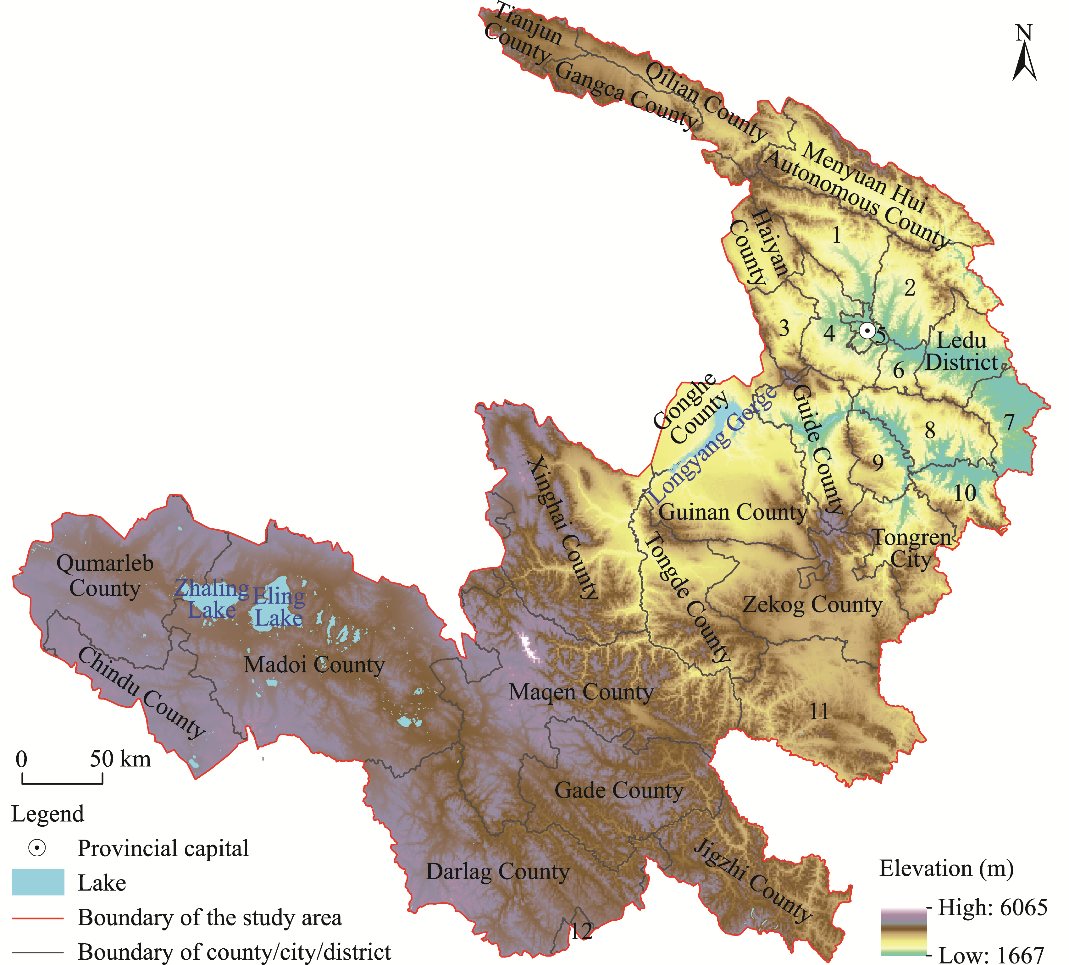
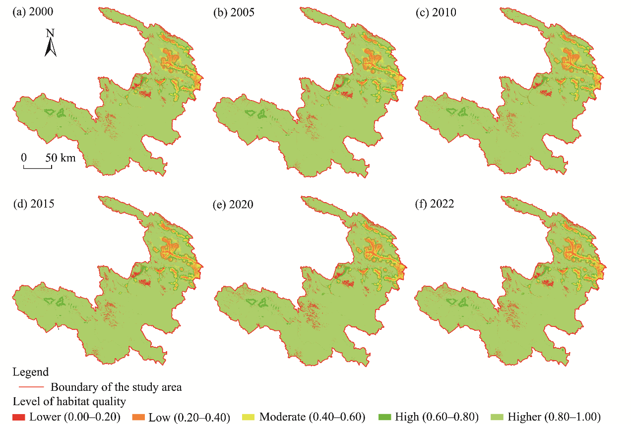
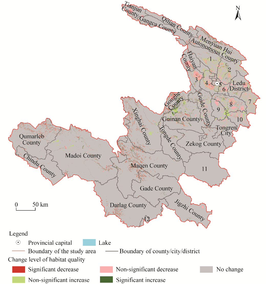
Abstract Habitat quality is an important indicator for evaluating the quality of ecosystem. The Qinghai Province section of the Yellow River Basin plays an important role in the ecological protection of the upper reaches of the Yellow River Basin. To comprehensively analysis the alterations of habitat quality in the Qinghai Province section of the Yellow River Basin, this study utilized the Integrated Valuation of Ecosystem Services and Tradeoffs (InVEST) model to calculate the habitat quality index and analyze the spatio-temporal variation characteristics of habitat quality in the study area from 2000 to 2022, and calculated seven landscape pattern indices (number of patches, patch density, largest patch index (LPI), landscape shape index (LSI), contagion index (CONTAG), Shannon diversity index, and Shannon evenness index) to research the variation of landscape pattern in the study area. The results showed that the number of patches, patch density, LPI, LSI, Shannon diversity index, and Shannon evenness index increased from 2000 to 2022, while the CONTAG decreased, indicating that the landscape pattern in the Qinghai Province section of the Yellow River Basin changed in the direction of distribution fragmentation, shape complexity, and heterogeneity. The average value of the habitat quality index in the Qinghai Province section of the Yellow River Basin from 2000 to 2022 was 0.90. Based on the value of habitat quality index, we divided the level of habitat quality into five categories: lower (0.00-0.20), low (0.20-0.40), moderate (0.40-0.60), high (0.60-0.80), and higher (0.80-1.00). Most areas were at the higher habitat quality level. The lower habitat quality patches were mainly distributed in Longyang Gorge and Yellow River-Huangshui River Valley. From 2000 to 2022, the habitat quality in most areas was stable; the increase areas were mainly distributed in Guinan County, while the decrease areas were mainly distributed in Xining City, Maqen County, Xinghai County, Qumarleb County, and Darlag County. To show the extent of habitat quality variation, we calculated Sen index. The results showed that the higher habitat quality area had a decrease trending, while other categories had an increasing tendency, and the decreasing was faster than increasing. The research results provide scientific guidance for promoting ecological protection and high-quality development in the Qinghai Province section of the Yellow River Basin.
|
|
Received: 11 May 2024
Published: 30 September 2024
|
|
|
|
Corresponding Authors:
*LI Runjie (E-mail: rjl@126.com)
|
|
|
| [1] |
Aneseyee A B, Noszczyk T, Soromessa T, et al. 2020. The InVEST habitat quality model associated with land use/cover changes: a qualitative case study of the Winike Watershed in the Omo-Gibe Basin, Southwest Ethiopia. Remote Sensing, 12(7): 1103, doi: 10.3390/rs12071103.
|
|
|
| [2] |
Bao Y B, Liu K, Li T, et al. 2015. Effects of land use change on habitat based on InVEST model—Taking Yellow River Wetland Nature Reserve in Shaanxi Province as an example. Arid Zone Research, 32(3): 622-629. (in Chinese)
|
|
|
| [3] |
Cai W M, Tang H J, Chen Y Q, et al. 2004. Landscape pattern of rural residential areas in Yellow River Delta in recent 20 years. Resources Science, 26(5): 89-97. (in Chinese)
|
|
|
| [4] |
Chen C, Park T, Wang X H, et al. 2019. China and India lead in greening of the world through land-use management. Nature Sustainability, 2(2): 122-129.
doi: 10.1038/s41893-019-0220-7
pmid: 30778399
|
|
|
| [5] |
Chen Y, Xia R, Hou X K. 2021. Upper Yellow River Basin water ecological environment problems and countermeasures—Taking Huangshui River Typical Basin as an example. Environmental Protection, 49(13): 17-19. (in Chinese)
|
|
|
| [6] |
Deng G M, Yan X K, Xu G L, et al. 2024. Land use change and habitat quality evolution in county level in NanxiongBasin, northern Guangdong Province. Journal of Chinese Urban Forestry, doi: 10.12169/zgcsly.2024.06.09.0001. (in Chinese)
|
|
|
| [7] |
Duan B Q, Chen W X, Zeng J. 2024. Landscape fragmentation of rural settlements and its influencing factors in China. Journal of Agricultural Resources and Environment, doi: 10.13254/j.jare.2023.0610. (in Chinese)
|
|
|
| [8] |
Fellman J B, Hood E, Dryer W, et al. 2015. Stream physical characteristics impact habitat quality for Pacific salmon in two temperate coastal watersheds. PLoS ONE, 10(7): e0132652, doi: 10.1371/journal.pone.0132652.
|
|
|
| [9] |
Guo J, Zhang Q, Song M H, et al. 2020. Status and function improvement technology of the grassland ecosystem in the upper Yellow River Basin. Acta Agrestia Sinica, 28(5): 1173-1184. (in Chinese)
doi: 10.11733/j.issn.1007-0435.2020.05.001
|
|
|
| [10] |
He P, Zhang H R. 2009. Study on factor analysis and selection of common landscape metrics. Forest Research, 22(4): 470-474. (in Chinese)
|
|
|
| [11] |
Hou J X, Pan H H, Du Z Q, et al. 2024. Spatiotemporal analysis of water ecosystem services of the Yellow River Basin in Shanxi Province. Arid Land Geography, 47(6): 1047-1060. (in Chinese)
doi: 10.12118/j.issn.1000-6060.2023.346
|
|
|
| [12] |
Huang B, Zhang H W. 2024. Evolution and driving force analysis of landscape ecological risk in Guanzhong Plain urban agglomeration. Environmental Ecology, 6(6): 40-48. (in Chinese)
|
|
|
| [13] |
Jia T C, Hu X W. 2024. Spatial-temporal change and driving force of carbon storage in Three-River-Source National Park based on PLUS-InVEST-Geodector Model. Environmental Science, doi: 10.13227/j.hjkx.202310046. (in Chinese)
|
|
|
| [14] |
Jiang F G, Deng M L, Long Y, et al. 2022. Spatial pattern and dynamic change of vegetation greenness from 2001 to 2020 in Tibet, China. Frontiers in Plant Science, 13: 892625, doi: 10.3389/fpls.2022.892625.
|
|
|
| [15] |
Jin S H, Liu X, Yang J J, et al. 2022. Spatial-temporal changes of land use/cover change and habitat quality in Sanjiang Plain from 1985 to 2017. Frontiers in Environmental Science, 10: 1032584, doi: 10.3389/fenvs.2022.1032584.
|
|
|
| [16] |
Lai Z Y, Liao F Q, Shu X B, et al. 2024. Spatio-temporal pattern evolution and prediction of habitat quality in Ganjiang River Basin. Resources and Environment in the Yangtze Basin, 1-21. (in Chinese)
|
|
|
| [17] |
Lei J R, Chen Y Q, Li L M, et al. 2022. Spatiotemporal change of habitat quality in Hainan Island of China based on changes in land use. Ecological Indicators, 145: 109707, doi: 10.1016/j.ecolind.2022.109707.
|
|
|
| [18] |
Li D K, Ding S Y, Liang G F, et al. 2014. Landscape heterogeneity of mountainous and hilly area in the western Henan Province based on moving window method. Acta Ecologica Sinica, 34(12): 3414-3424. (in Chinese)
|
|
|
| [19] |
Li L F, Li X J, Niu B B, et al. 2023a. A study on the dynamics of landscape patterns in the Yellow River Delta Region. Water, 15(4): 819, doi: 10.3390/w15040819.
|
|
|
| [20] |
Li N, Wang L, Wen G C, et al. 2023b. Analysis of area change and driving forces for the Eling Lake at the source of the Yellow River. Bulletin of Surveying and Mapping, 10: 7-13, 33. (in Chinese)
|
|
|
| [21] |
Lin J P, Zhu C H, Deng A Z, et al. 2022. Causes of changing woodland landscape patterns in southern China. Forests, 13(12): 2183, doi: 10.3390/f13122183.
|
|
|
| [22] |
Liu C Y, Yang J, Xie B P, et al. 2023a. Temporal and spatial characteristics of habitat quality and its topographic gradient effect in the Gansu-Qinghai section of the Yellow River Basin. Journal of Agricultural Resources and Environment, 40(2): 372-383.
|
|
|
| [23] |
Liu H M, Fang C L, Li Y H. 2019. The coupled human and natural cube: A conceptual framework for analyzing urbanization and eco-environment interactions. Acta Geographica Sinica, 74(8): 1489-1507. (in Chinese)
doi: 10.11821/dlxb201908001
|
|
|
| [24] |
Liu J Y, Xu D W, Xu J. 2024. Analysis of landscape patterns and spatio-temporal evolution of habitat quality in the Pu River Basin based on the InVEST model. Journal of Soil and Water Conservation, 38(2): 258-267. (in Chinese)
|
|
|
| [25] |
Liu X H, Qiao X J. 2024. Spatio-temporal variation of habitat quality of the Giant Panda National Park in the Qinling Area, China. Journal of Northwest Forestry University, 39(3): 179-188. (in Chinese)
|
|
|
| [26] |
Liu X Y, Liu C, Nie R H, et al. 2023b. Spatio-temporal variation in water use efficiency and its determinants in 2000-2014 in the source region of Yellow River. Journal of Irrigation and Drainage, 42(9): 61-67. (in Chinese)
|
|
|
| [27] |
Long Y, Jiang F G, Deng M L, et al. 2023. Spatial-temporal changes and driving factors of eco-environmental quality in the Three-North region of China. Journal of Arid Land, 15(3): 231-252.
|
|
|
| [28] |
Lü L T, Zhang J, Peng Q Z, et al. 2019. Landscape pattern analysis and prediction in the Dongjiang River Basin. Acta Ecologica Sinica, 39(18): 6850-6859. (in Chinese)
|
|
|
| [29] |
Ma S Q, Ding W W, Li F J, et al. 2023. Countermeasures of the ecological protection and restoration in the Yellow River Basin in Qinghai Province. Environmental Protection, 51(22): 18-22. (in Chinese)
|
|
|
| [30] |
Mu Q, Jiang L L, Zhu Y H, et al. 2023. Prediction of changes in and use and habitat quality in Suzhou. Environmental Monitoring Management and Technology, 35(6): 15-21. (in Chinese)
|
|
|
| [31] |
Nelson E, Mendoza G, Regetz J, et al. 2009. Modeling multiple ecosystem services, biodiversity conservation, commodity production, and tradeoffs at landscape scales. Frontiers in Ecology and the Environment, 7(1): 4-11.
|
|
|
| [32] |
Ou Y Z Y, Liu J G, Xiao H, et al. 2001. An assessment of giant panda habitat in Wolong Nature Reserve. Acta Ecologica Sinica, 21(11): 1869-1874. (in Chinese)
|
|
|
| [33] |
Pan Y, Yin Y H, Hou W J, et al. 2022. Spatiotemporal variation of habitat quality in the source region of the Yellow River based on land use and vegetation cover changes. Acta Ecologica Sinica, 42(19): 7978-7988. (in Chinese)
|
|
|
| [34] |
Paudel S, Yuan F. 2012. Assessing landscape changes and dynamics using patch analysis and GIS modeling. International Journal of Applied Earth Observation and Geoinformation, 16: 66-76.
|
|
|
| [35] |
Peng J, Xu F X, Wu J, et al. 2019. Spatial differentiation of habitat quality in typical tourist city and their influencing factors mechanisms: a case study of Huangshan City. Resources and Environment in the Yangtze Basin, 28(10): 2397-2409. (in Chinese)
|
|
|
| [36] |
Qi Y L, Ma Y L, Zhang H W, et al. 2024. Relationship between population density of plateau pika and environmental factors. Pratacultural Science, 41(6): 1441-1452. (in Chinese)
|
|
|
| [37] |
Shi J X, Liang X Y, Wei Z, et al. 2024. Spatial-temporal heterogeneity in the influence of landscape patterns on trade-offs/synergies among ecosystem services: a case study of the Loess Plateau of northern Shaanxi. Environmental Science and Pollution Research, 31(4): 6144-6159.
|
|
|
| [38] |
Sui X, Tong F, Yao C Q, et al. 2007. Land uses and landscape patterns of Qinghai Province in the Yellow River Basin. Journal of Soil and Water Conservation, 27(2): 123-127. (in Chinese)
|
|
|
| [39] |
Wang A, Zhang M M, Al Kafy A, et al. 2023a. Predicting the impacts of urban land change on LST and carbon storage using InVEST, CA-ANN and WOA-LSTM models in Guangzhou, China. Earth Science Informatics, 16(1): 437-454.
|
|
|
| [40] |
Wang B X, Cheng W M. 2022. Effects of land use/cover on regional habitat quality under different geomorphic types based on InVEST model. Remote Sensing, 14(5): 1279, doi: 10.3390/rs14051279.
|
|
|
| [41] |
Wang F W, Zhang Y H. 2023. Landscape fragmentation analysis and eco-environmental quality assessment at the catchment scale. Journal of Natural Disasters, 32(1): 67-75. (in Chinese)
|
|
|
| [42] |
Wang G X, Li N, Hu H C. 2009. Hydrologic effect of ecosystem responses to climatic change in the source regions of Yangtze River and Yellow River. Progress in Climate Change Research, 5(4): 202-208. (in Chinese)
|
|
|
| [43] |
Wang P, Qin S T, Hu H R. 2023b. Spatial-temporal evolution characteristics of land use change and habitat quality in the Lhasa River Basin over the past three decades. Arid Zone Research, 40(3): 492-503. (in Chinese)
|
|
|
| [44] |
Wang Y, Gao J X, Jin Y, et al. 2020. Habitat quality of farming-pastoral ecotone in Bairin Right Banner, Inner Mongolia based on land use change and InVEST model from 2005 to 2015. Journal of Ecology and Rural Environment, 36(5): 654-662. (in Chinese)
|
|
|
| [45] |
Wang Y Q, Sun X Y. 2024. Trade-off and synergy of ecosystem services in the Yellow River Basin and their spatiotemporal heterogeneity. Environmental Science, doi: 10.13227/j.hjkx.202402126. (in Chinese)
|
|
|
| [46] |
Wang Z Y, Shi P J, Li X H, et al. 2024. Response mechanism and promotion path of habitat quality to land use changes in the Hexi Corridor Area. Environmental Science, doi: 10.13227/j.hjkx.202312250. (in Chinese)
|
|
|
| [47] |
Wu C X, Gao P, Xu R R, et al. 2024. Influence of landscape pattern changes on water conservation capacity: A case study in an arid/semiarid region of China. Ecological Indicators, 163: 112082, doi: 10.1016/j.ecolind.2024.112082.
|
|
|
| [48] |
Wu L, Zhou Z F, Zhang L, et al. 2023. Response of landscape pattern change to habitat quality in Karst Area. Environmental Science and Technology, 46(9): 206-217. (in Chinese)
|
|
|
| [49] |
Wu X F, Li G X, Pan X P, et al. 2015. Response of vegetation cover to temperature and precipitation in the source region of the Yellow River. Resources Science, 37(3): 512-521.
|
|
|
| [50] |
Xu Y, Gao M K, Zhang Z X. 2024. Land use change and its impact on habitat quality in the middle and lower reaches of the Yangtze River based on InVEST model. Research of Soil and Water Conservation, 31(5): 355-364. (in Chinese)
|
|
|
| [51] |
Yan L, Cao G C, Kang L G, et al. 2024. Analysis of spatial and temporal changes in habitat quality and driving factors in Gonghe County using the InVEST model. Arid Zone Research, 41(2): 314-325. (in Chinese)
doi: 10.13866/j.azr.2024.02.14
|
|
|
| [52] |
Yang F, Yang L Y, Fang Q Y, et al. 2024. Impact of landscape pattern on habitat quality in the Yangtze River Economic Belt from 2000 to 2030. Ecological Indicators, 166: 112480, doi: 10.1016/j.ecolind.2024.112480.
|
|
|
| [53] |
Yang J, Huang X. 2021. The 30 m annual land cover dataset and its dynamics in China from 1990 to 2019. Earth System Science Data Discussions, 13(8): 3907-3925.
|
|
|
| [54] |
Yang W P, Shao H Y, Huang J R, et al. 2023a. Habitat quality assessment of Qinghai-Tibet Plateau National Park cluster. National Parks (English and Chinese), 1(2): 99-109. (in Chinese)
|
|
|
| [55] |
Yang X G, Ma L Y, Sun H F, et al. 2023b. Study on key paths of comprehensive integration of Qinghai Province into the national strategy for ecological protection and high-quality development of the Yellow River Basin. Qinghai Science and Technology, 30(6): 19-25. (in Chinese)
|
|
|
| [56] |
Yang Z K, Tian J, Li W Y, et al. 2021. Spatio-temporal pattern and evolution trend of ecological environment quality in the Yellow River Basin. Acta Ecologica Sinica, 41(19): 7627-7636. (in Chinese)
|
|
|
| [57] |
Zang Y Z, Liu Y S, Yang Y Y. 2019. Land use pattern change and its topographic gradient effect in the mountainous areas: A case study of Jinggangshan City. Journal of Natural Resources, 34(7): 1391-1404. (in Chinese)
|
|
|
| [58] |
Zeng X Y, Song Y H. 2023. Study on the biodiversity distribution pattern of the green space in the central city of Kunming based on the key species and habitat quality assessment. Chinese Garden, 39(9): 126-132. (in Chinese)
|
|
|
| [59] |
Zhang G K, Deng W, Lü X G, et al. 2007. The dynamic change of wetland landscape patterns in Xinkai River Basin. Journal of Natural Resources, 22(3): 204-210. (in Chinese)
|
|
|
| [60] |
Zhang J T, Zhao F X, Chen J H, et al. 2023. Relationship between species diversity and biomass of different types of alpine grasslands on the Qinghai-Tibetan Plateau and their influencing elements. Grassland Science, 40(3): 616-626. (in Chinese)
|
|
|
| [61] |
Zhang J X, Gu Y X, Shen J Q, et al. 2024a. Analysis of spatiotemporal changes and driving factors of ecological environment quality in the Yellow River Basin. Envrionmental Science, doi: 10.13227/j.hjkx.202401141. (in Chinese)
|
|
|
| [62] |
Zhang X Y, Jia W W, Lu S X, et al. 2024b. Ecological assessment and driver analysis of high vegetation cover areas based on new remote sensing index. Ecological Informatics, 82: 102786, doi: 10.1016/j.ecoinf.2024.102786.
|
|
|
| [63] |
Zhang X Y, Zhou Z X, Tang Z X, et al. 2024c. Spatio-temporal variation and prediction of habitat quality in Wuding River Basin. Journal of Desert Research, 44(3): 75-84. (in Chinese)
|
|
|
| [64] |
Zhang Y Y, Cai X B, Yang C, et al. 2019. Driving force analysis of landscape pattern changes in Honghu Wetland Nature Reserve in recent 40 years. Journal of Lake Sciences, 31(1): 171-182. (in Chinese)
|
|
|
| [65] |
Zhi F, Zhou Z H, Zhao M, et al. 2024. Temporal and spatial evolution characteristics of carbon storage in Hefei ecosystem based on PLUS and InVEST models. Journal of Soil and Water Conservation, 38(2): 205-215. (in Chinese)
|
|
|
| [66] |
Zhong L N, Wang J. 2017. Evaluation on effect of land consolidation on habitat quality based on InVEST model. Transactions of the Chinese Society of Agricultural Engineering, 33(1): 250-255. (in Chinese)
|
|
|
| [67] |
Zhu J, Gong J, Li J Y. 2020. Spatiotemporal change of habitat quality in ecologically sensitive areas of eastern Qinghai-Tibet Plateau: A case study of the Hehuang Valley, Qinghai Province. Resource Science, 42(5): 991-1003. (in Chinese)
|
|
|
| [68] |
Zhu W H, Zou H, Liu T, et al. 2024. Evaluation of eco-geological environment quality of Bailianhe wetland in eastern Hubei Province. Resources Environment & Engineering, 38(4): 427-436. (in Chinese)
|
|
|
|
Viewed |
|
|
|
Full text
|
|
|
|
|
Abstract
|
|
|
|
|
Cited |
|
|
|
|
| |
Shared |
|
|
|
|
| |
Discussed |
|
|
|
|