| Research article |
|

|
|
|
| A new monitoring index for ecological vulnerability and its application in the Yellow River Basin, China from 2000 to 2022 |
GUO Bing1, XU Mei1, ZHANG Rui2,*( ), LUO Wei3 ), LUO Wei3 |
1School of Civil Engineering and Geomatics, Shandong University of Technology, Zibo 255000, China
2Key Laboratory of Remote Sensing of Gansu Province, Heihe Remote Sensing Experimental Research Station, Northwest Institute of Eco-Environment and Resources, Chinese Academy of Sciences, Lanzhou 730000, China
3North China Institute of Aerospace Engineering, Langfang 065000, China |
|
|
|
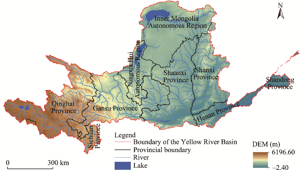
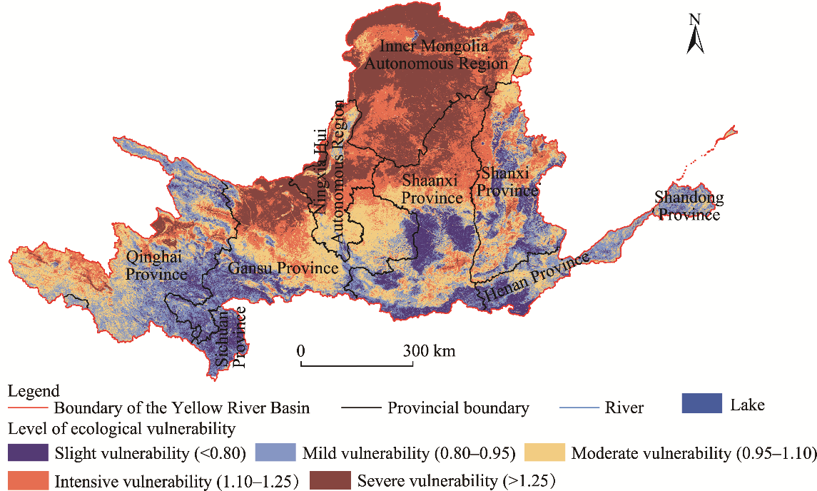
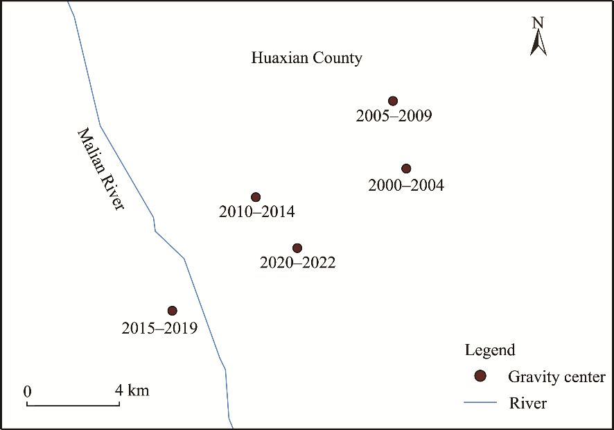
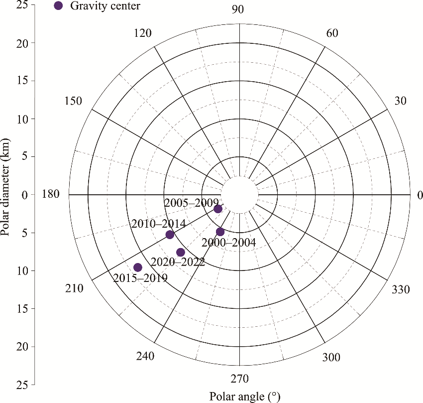
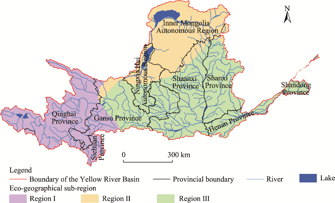
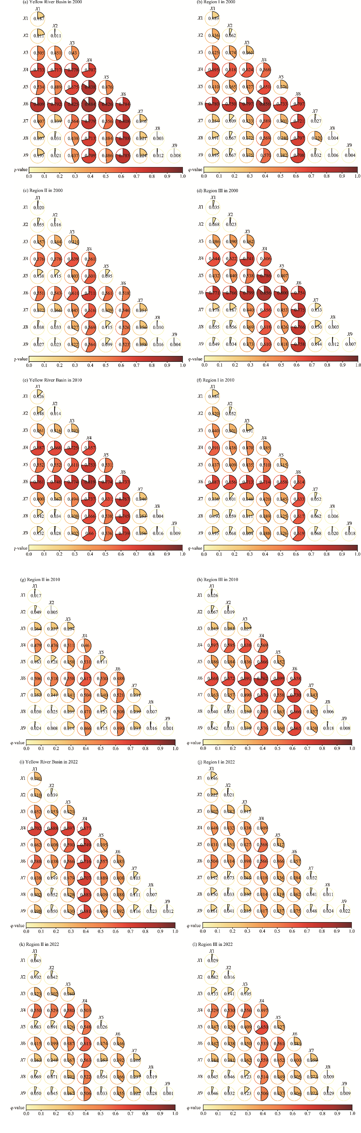
Abstract The ecological environment of the Yellow River Basin has become more fragile under the combined action of natural and manmade activities. However, the change mechanisms of ecological vulnerability in different sub-regions and periods vary, and the reasons for this variability are yet to be explained. Thus, in this study, we proposed a new remote sensing ecological vulnerability index by considering moisture, heat, greenness, dryness, land degradation, and social economy indicators and then analyzed and disclosed the spatial and temporal change patterns of ecological vulnerability of the Yellow River Basin, China from 2000 to 2022 and its driving mechanisms. The results showed that the newly proposed remote sensing ecological vulnerability index had a high accuracy, at 86.36%, which indicated a higher applicability in the Yellow River Basin. From 2000 to 2022, the average remote sensing ecological vulnerability index of the Yellow River Basin was 1.03, denoting moderate vulnerability level. The intensive vulnerability area was the most widely distributed, which was mostly located in the northern part of Shaanxi Province and the eastern part of Shanxi Province. From 2000 to 2022, the ecological vulnerability in the Yellow showed an overall stable trend, while that of the central and eastern regions showed an obvious trend of improvement. The gravity center of ecological vulnerability migrated southwest, indicating that the aggravation of ecological vulnerability in the southwestern regions was more severe than in the northeastern regions of the basin. The dominant single factor of changes in ecological vulnerability shifted from normalized difference vegetation index (NDVI) to temperature from 2000 to 2022, and the interaction factors shifted from temperature∩NDVI to temperature∩precipitation, which indicated that the global climate change exerted a more significant impact on regional ecosystems. The above results could provide decision support for the ecological protection and restoration of the Yellow River Basin.
|
|
Received: 14 April 2024
Published: 30 September 2024
|
|
|
|
Corresponding Authors:
*ZHANG Rui (zhangrui10@radi.ac.cn)
|
|
|
| [1] |
Ankush R, Saurabh K G, Suraj K S, et al. 2023. Predicting future land use utilizing economic and land surface parameters with ANN and Markov chain models. Earth, 4(3): 728-751.
|
|
|
| [2] |
Bai X, Zhang Z W, Li Z, et al. 2023. Spatial heterogeneity and formation mechanism of eco-environmental quality in the Yellow River Basin. Sustainability, 15(14): 10878, doi: 10.3390/su151410878.
|
|
|
| [3] |
Cai Z C, Zhang Z, Zhao F, et al. 2023. Assessment of eco-environmental quality changes and spatial heterogeneity in the Yellow River Delta based on the remote sensing ecological index and geo-detector model. Ecological Informatics, 77: 102203, doi: 10.1016/j.ecoinf.2023.102203.
|
|
|
| [4] |
Cheng Y, Zhang L J, Zhang Z Q, et al. 2022. Spatiotemporal variation and influence factors of vegetation cover in the Yellow River Basin (1982-2021) based on GIMMS NDVI and MOD13A1. Water, 14(20): 3274-3274.
|
|
|
| [5] |
Du W P, Hao Z X, Bai M X, et al. 2023. Spatiotemporal variation in the Meteorological drought comprehensive index in the Beijing-Tianjin-Hebei Region during 1961-2023. Water, 15(24): 4230, doi: 10.3390/w15244230.
|
|
|
| [6] |
Duo L H, Wang J Q, Zhang F Q, et al. 2023. Assessing the spatiotemporal evolution and drivers of ecological environment quality using an enhanced remote sensing ecological index in Lanzhou City, China. Remote Sensing, 15(19): 4704, doi: 10.3390/rs15194704.
|
|
|
| [7] |
Guo Y, Zhang L F, He Y, et al. 2024. LSTM time series NDVI prediction method incorporating climate elements: A case study of Yellow River Basin, China. Journal of Hydrology, 629: 130518, doi: 10.1016/j.jhydrol.2023.130518.
|
|
|
| [8] |
He B S, Han F, Han J L, et al. 2023a. The ecological evolution analysis of heritage sites based on the remote sensing ecological index—A case study of Kalajun-Kuerdening World Natural Heritage Site. Remote Sensing, 15(5): 1179-1179.
|
|
|
| [9] |
He X R, Cai C Y, Tang J X, et al. 2023b. Analysis of coupling coordination and obstacle factors between tourism development and ecosystem services value: A case study of the Yellow River Basin, China. Ecological Indicators, 157: 111234, doi: 10.1016/j.ecolind.2023.111234.
|
|
|
| [10] |
Hou K, Tao W D, Wang L M, et al. 2020. Study on hierarchical transformation mechanisms of regional ecological vulnerability and its applicability. Ecological Indicators, 114: 106343, doi: 10.1016/j.ecolind.2020.106343.
|
|
|
| [11] |
Hu W, Liu J S. 2023. The coupling and coordination of urban modernization and low-carbon development. Sustainability, 15(19): 14335, doi: 10.3390/su151914335.
|
|
|
| [12] |
Huang J, Zhong P S, Zhang J Z, et al. 2023. Spatial-temporal differentiation and driving factors of ecological resilience in the Yellow River Basin, China. Ecological Indicators, 154: 110763, doi: 10.1016/j.ecolind.2023.110763.
|
|
|
| [13] |
Kang N. 2023. Ecological vulnerability assessment based on 'nature-humanity-response' model. Environment and Development, 35(1): 52-57. (in Chinese)
|
|
|
| [14] |
Kong X L, Han M, Li Y L, et al. 2024. Spatial differentiation and formation mechanism of ecological sensitivity in large river basins: A case study of the Yellow River Basin, China. Ecological Indicators, 158: 111571, doi: 10.1016/j.ecolind.2024.111571.
|
|
|
| [15] |
Krzyśko M, Nijkamp P, Ratajczak W, et al. 2024. Spatio-temporal principal component analysis. Spatial Economic Analysis, 19(1): 8-29.
|
|
|
| [16] |
Li H C, Guan Q Y, Sun Y F, et al. 2022. Spatiotemporal analysis of the quantitative attribution of soil water erosion in the upper reaches of the Yellow River Basin based on the RUSLE-TLSD model. Catena, 212: 106081, doi: 10.1016/j.catena.2022.106081.
|
|
|
| [17] |
Lin Z Q, Liu Y Y, Wen Z M, et al. 2023. Spatial-temporal variation characteristics and driving factors of net primary production in the Yellow River Basin over multiple time scales. Remote Sensing, 15(22): 5273, doi: 10.3390/rs15225273.
|
|
|
| [18] |
Liu X Q, Liu Y S. 2009. Research on the sustainable development of vulnerable ecological region based on AHP—A case study of Yulin City. Journal of Arid Land Resources and Environment, 23(5): 19-23. (in Chinese)
|
|
|
| [19] |
Lu Q G, Zhang Y D, Song B C, et al. 2023. The responses of ecological indicators to compound extreme climate indices in southwestern China. Ecological Indicators, 157: 11253, doi: 10.1016/j.ecolind.2023.111253.
|
|
|
| [20] |
Niu W T, Shi J Y, Xu Z Z, et al. 2022. Evaluating the sustainable land use in ecologically fragile regions: A case study of the Yellow River Basin in China. International Journal of Environmental Research and Public Health, 19(6): 3222, doi: 10.3390/ijerph19063222.
|
|
|
| [21] |
Niu H P, Xiu Z Y, Xiao D Y. 2024. Impact of land-use change on ecological vulnerability in the Yellow River Basin based on a complex network model. Ecological Indicators, 166: 112212, doi: 10.1016/j.ecolind.2024.112212.
|
|
|
| [22] |
Ren H Y, Zhou X, Zhang D, et al. 2018. Changes of ecological risk in Karst mountain city during rapid urbanization—A case study in Huaxi District, Guiyang. Journal of Guizhou Normal University (Natural Sciences), 36(5): 16-23. (in Chinese)
|
|
|
| [23] |
Shan Y, Wang N L. 2023. Spatiotemporal evolution and the influencing factors of China's high-tech industry GDP using a geographical detector. Sustainability, 15(24): 16678, doi: 10.3390/su152416678.
|
|
|
| [24] |
Shi X X, Li J, Liu J F, et al. 2008. Eco-environment vulnerability evaluation based on successive projection pursuit model: a case study of Selangor, Malaysia. Journal of Natural Disasters, 17(6): 129-133.
|
|
|
| [25] |
Sun P J, Xiu C L. 2011. Study on the vulnerability of economic development in mining cities based on the PSE Model. Geographical Research, 30(2): 301-310. (in Chinese)
|
|
|
| [26] |
Sun Y F, Wang N L. 2022. Sustainable urban development of the π-shaped curve area in the Yellow River Basin under ecological constraints: A study based on the improved ecological footprint model. Journal of Cleaner Production, 337: 130452, doi: 10.1016/j.jclepro.2022.130452.
|
|
|
| [27] |
Tanago I G, Urquijo J, Blauhut V, et al. 2016. Learning from experience: a systematic review of assessments of vulnerability to drought. Natural Hazards, 80(2): 951-973.
|
|
|
| [28] |
Wang K L, Zhou J, Tan M L, et al. 2024a. Impacts of vegetation restoration on soil erosion in the Yellow River Basin, China. Catena, 234: 107547, doi: 10.1016/j.catena.2023.107547.
|
|
|
| [29] |
Wang Q X, Zhang P Y, Chang Y H, et al. 2024b. Landscape pattern evolution and ecological risk assessment of the Yellow River Basin based on optimal scale. Ecological Indicators, 158: 111381, doi: 10.1016/j.ecolind.2023.111381.
|
|
|
| [30] |
Wang X L, Zhang S R, Zhao X, et al. 2023a. Exploring the relationship between the eco-environmental quality and urbanization by utilizing sentinel and Landsat data: A case study of the Yellow River Basin. Remote Sensing, 15(3): 743, doi: 10.3390/rs15030743.
|
|
|
| [31] |
Wang X R, Duan L R, Zhang T J, et al. 2023b. Ecological vulnerability of China's Yellow River Basin: evaluation and socioeconomic driving factors. Environmental Science and Pollution Research, 30(54): 115915-115928.
|
|
|
| [32] |
Wang Y, Xia W T, Liang T G, et al. 2010. Spatial and temporal dynamic changes of net primary product based on MODIS vegetation index in Gannan grassland. Acta Prataculturae Sinica, 19(1): 201-210. (in Chinese)
|
|
|
| [33] |
Wang Z Y, Xiong H X, Zhang F W, et al. 2024c. Sustainable development assessment of ecological vulnerability in arid areas under the influence of multiple indicators. Journal of Cleaner Production, 436: 140629, doi: 10.1016/j.jclepro.2024.140629.
|
|
|
| [34] |
Wei S F, Dong Y, Qiu Y X, et al. 2023. Temporal and spatial analysis of vegetation cover change in the Yellow River Delta based on Landsat and MODIS time series data. Environmental Monitoring and Assessment, 195(9): 1057, doi: 10.1007/s10661-023-11652-5.
|
|
|
| [35] |
Wen B Q, Huang C L, Zhou C, et al. 2023a. Spatiotemporal dynamics and driving factors of soil erosion in the Beiluo River Basin, Loess Plateau, China. Ecological Indicators, 155: 110976, doi: 10.1016/j.ecolind.2023.110976.
|
|
|
| [36] |
Wen G C, Wu B J, Wang L, et al. 2023b. Analysis of eco-environmental geological problems and their driving forces in the Henan section of the Yellow River Basin, China. Sustainability, 15(8): 6818, doi: 10.3390/su15086818.
|
|
|
| [37] |
Wu H, Fang S M, Zhang C, et al. 2022. Exploring the impact of urban form on urban land use efficiency under low-carbon emission constraints: A case study in China's Yellow River Basin. Journal of Environmental Management, 311: 114866, doi: 10.1016/j.jenvman.2022.114866.
|
|
|
| [38] |
Xia T T, Wang Y, Zhang S. 2023. Spatio-temporal coupling analysis of differences in regional grain-economy-population and water resources. Atmosphere, 14(3): 431, doi: 10.3390/atmos14030431.
|
|
|
| [39] |
Xiao H, Shao H Y, Long J M, et al. 2023. Spatial-temporal pattern evolution and geological influence factors analysis of ecological vulnerability in western Sichuan mountain region. Ecological Indicators, 155: 110980, doi: 10.1016/j.ecolind.2023.110980.
|
|
|
| [40] |
Xu Y Z, Hao S, Cui Y H, et al. 2023. Analysis of the spatiotemporal expansion and pattern evolution of urban areas in Anhui Province, China, based on nighttime light data. Ecological Indicators, 157: 11283, doi: 10.1016/j.ecolind.2023.111283.
|
|
|
| [41] |
Yang X L, Feng Z W, Chen Y Y. 2023. Evaluation and obstacle analysis of high-quality development in Yellow River Basin and Yangtze River Economic Belt, China. Humanities and Social Sciences Communications, 10(1): 757, doi: 10.1057/s41599-023-02278-6.
|
|
|
| [42] |
Yang Y H, Qin T L, Yan D H, et al. 2024. Analysis of the evolution of ecosystem service value and its driving factors in the Yellow River Source Area, China. Ecological Indicators, 158: 111344, doi: 10.1016/j.ecolind.2023.111344.
|
|
|
| [43] |
You G X, Chen T Y, Shen P X, et al. 2023. Designing an ecological network in Yichang central city in China based on habitat quality assessment. Sustainability, 15(10): 8313, doi: 10.3390/su15107835.
|
|
|
| [44] |
Yu S, Yang L L, Song Z J, et al. 2023. Measurement of land ecological security in the middle and lower reaches of the Yangtze River Base on the PSR Model. Sustainability, 15(19): 14098, doi: 10.3390/su151914098.
|
|
|
| [45] |
Yu T T, Leng H, Yuan Q, et al. 2022a. Vulnerability evaluation of villages based on social-ecological indicators and strategies for improvement: Case study of villages in the Northeast China Plain. Journal of Urban Planning and Development, 148(1): 04021059, doi: 10.1061/(asce)up.1943-5444.0000770.
|
|
|
| [46] |
Yu Z, Chen X Z, Zhou G Y, et al. 2022b. Natural forest growth and human induced ecosystem disturbance influence water yield in forests. Communications Earth Environment, 3(1): 148, doi: 10.1038/s43247-022-00483-w.
|
|
|
| [47] |
Yuan D H, Du M R, Yan C L, et al. 2024. Coupling coordination degree analysis and spatiotemporal heterogeneity between water ecosystem service value and water system in Yellow River Basin cities. Ecological Informatics, 79: 102440, doi: 10.1016/j.ecoinf.2023.102440.
|
|
|
| [48] |
Zhang Q, Wang G, Yuan R Y, et al. 2022. Dynamic responses of ecological vulnerability to land cover shifts over the Yellow River Basin, China. Ecological Indicators, 144: 109554, doi: 10.1016/j.ecolind.2022.109554.
|
|
|
| [49] |
Zhang J, Liu Y, Liu C, et al. 2023a. Study on the spatial and temporal evolution of high-quality development in nine provinces of the Yellow River Basin. Sustainability, 15(8): 6975, doi: 10.3390/su15086975.
|
|
|
| [50] |
Zhang M N, Qi S Z. 2023. The spatio-temporal evolution and driving factors of high-quality development in the Yellow River Basin during the period of 2010-2022. Sustainability, 15(18): 13512, doi: 10.3390/su151813512.
|
|
|
| [51] |
Zhang Y L, Wang Y L, Fu B J, et al. 2023b. Identification of critical ecological areas using the ecosystem multifunctionality-stability-integrity framework: A case study in the Yellow River Basin, China. Journal of Environmental Management, 348: 119296, doi: 10.1016/j.jenvman.2023.119296.
|
|
|
| [52] |
Zhang Y M. 2018. The evaluation of ecological vulnerability in western China: An exploratory analysis based on 45 cities in western China. Journal of Statistics and Information, 33(8): 74-84. (in Chinese)
|
|
|
| [53] |
Zhang Z W, Chang T Y, Qiao X N, et al. 2021. Eco-economic coordination analysis of the Yellow River Basin in China: Insights from major function-oriented zoning. Sustainability, 13(5): 2715, doi: 10.3390/su13052715.
|
|
|
| [54] |
Zhao Y X. 2003. Research of regionalism by ecological fragility based on condition of soil erosion in Shanxi Province. Journal of Soil and Water Conservation, 17(4): 71-74. (in Chinese)
|
|
|
| [55] |
Zhao Z Z, Ma Q, Wang Y, et al. 2024. Analysis and prediction of ecological vulnerability of the central plains urban agglomeration based on the SRP Model. Environmental Science, doi: 10.13227/j.hjkx.202403011.
|
|
|
| [56] |
Zuo L, Sun L G, Lu J J, et al. 2022. MODIS-based comprehensive assessment and spatial-temporal change monitoring of ecological quality in Beijing-Tianjin-Hebei region. Remote Sensing for Natural Resources, 34(2): 203-214. (in Chinese)
|
|
|
|
Viewed |
|
|
|
Full text
|
|
|
|
|
Abstract
|
|
|
|
|
Cited |
|
|
|
|
| |
Shared |
|
|
|
|
| |
Discussed |
|
|
|
|