| Research article |
|


|
|
|
| Projection and reclassification of land use types in Lanzhou, Northwest China |
ZHU Rong1,2, JIANG Youyan3,*( ), LEI Runzhi3 ), LEI Runzhi3 |
1Gansu Key Laboratory for Environmental Pollution Prediction and Control, College of Earth and Environmental Sciences, Lanzhou University, Lanzhou 730000, China
2Gansu Institute of Architectural Design and Research, Lanzhou 730020, China
3Lanzhou Regional Climate Center, Lanzhou 730020, China |
|
|
|
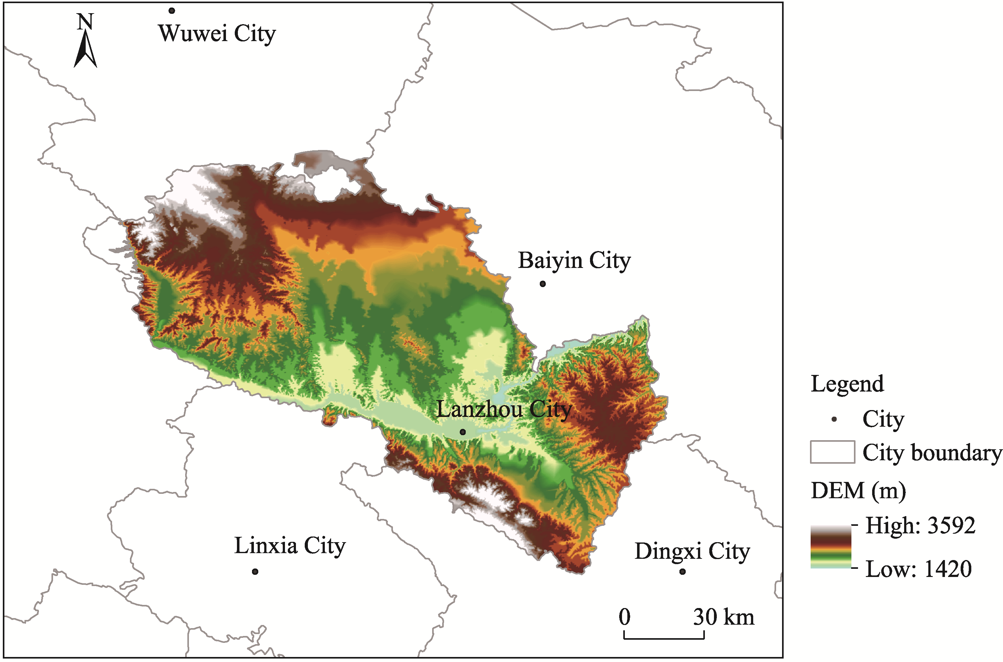
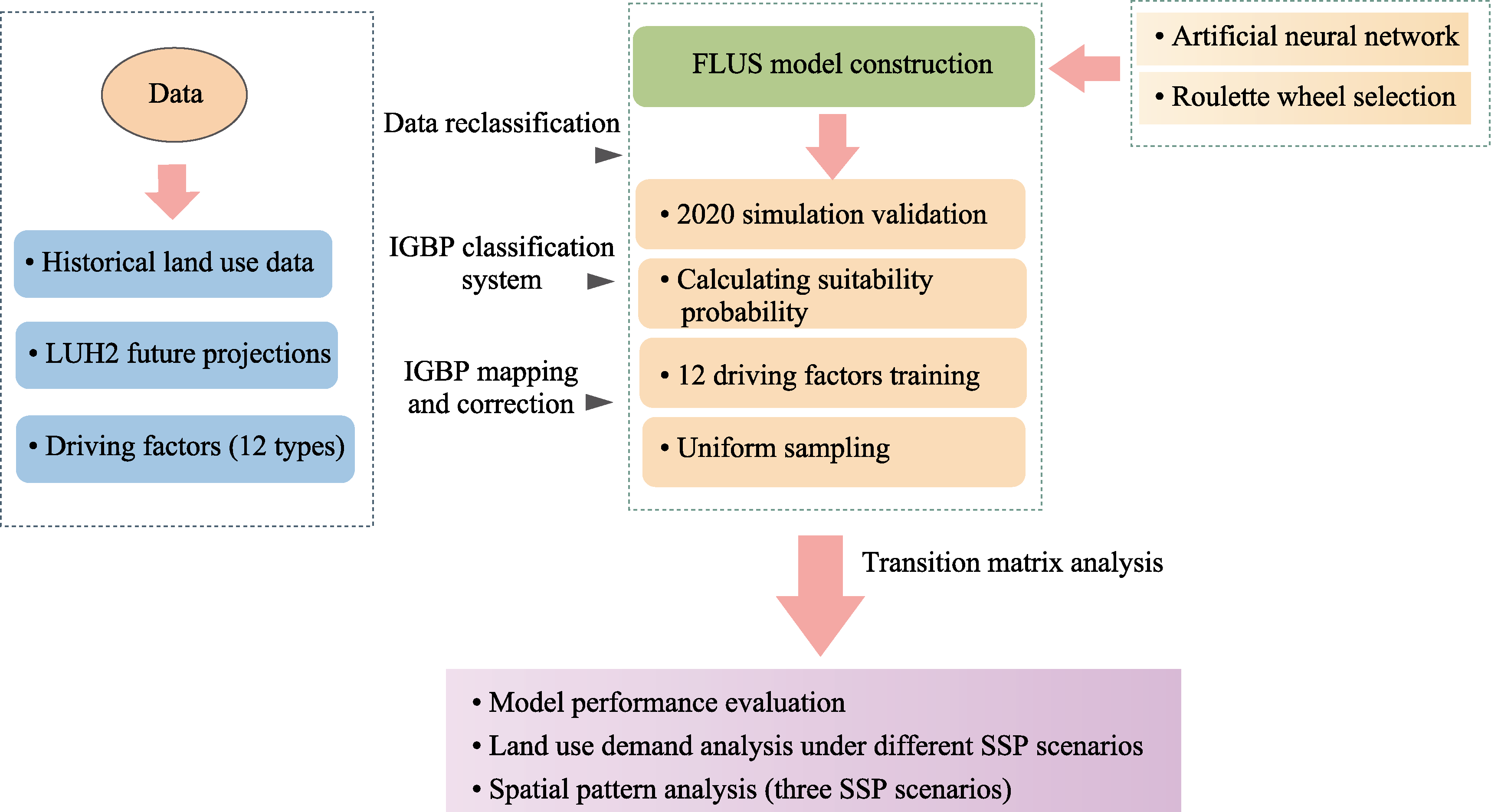
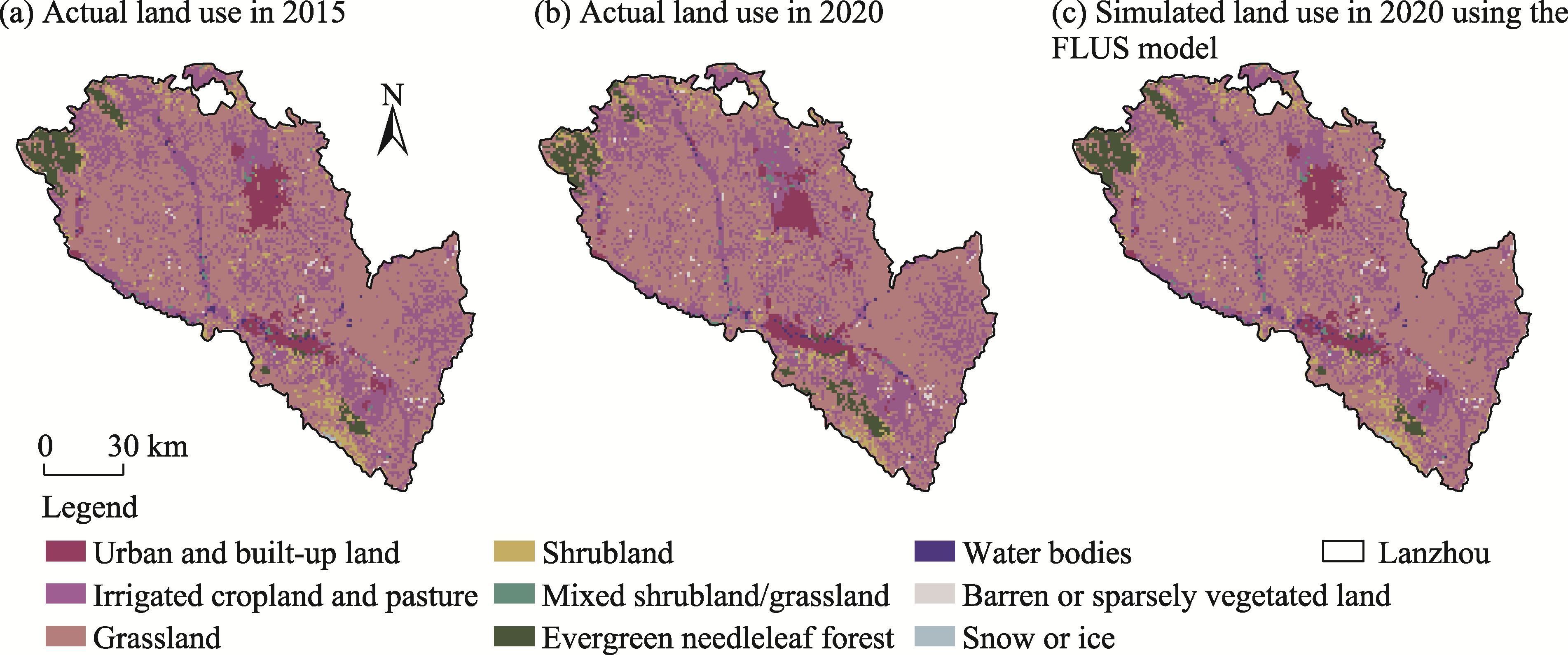
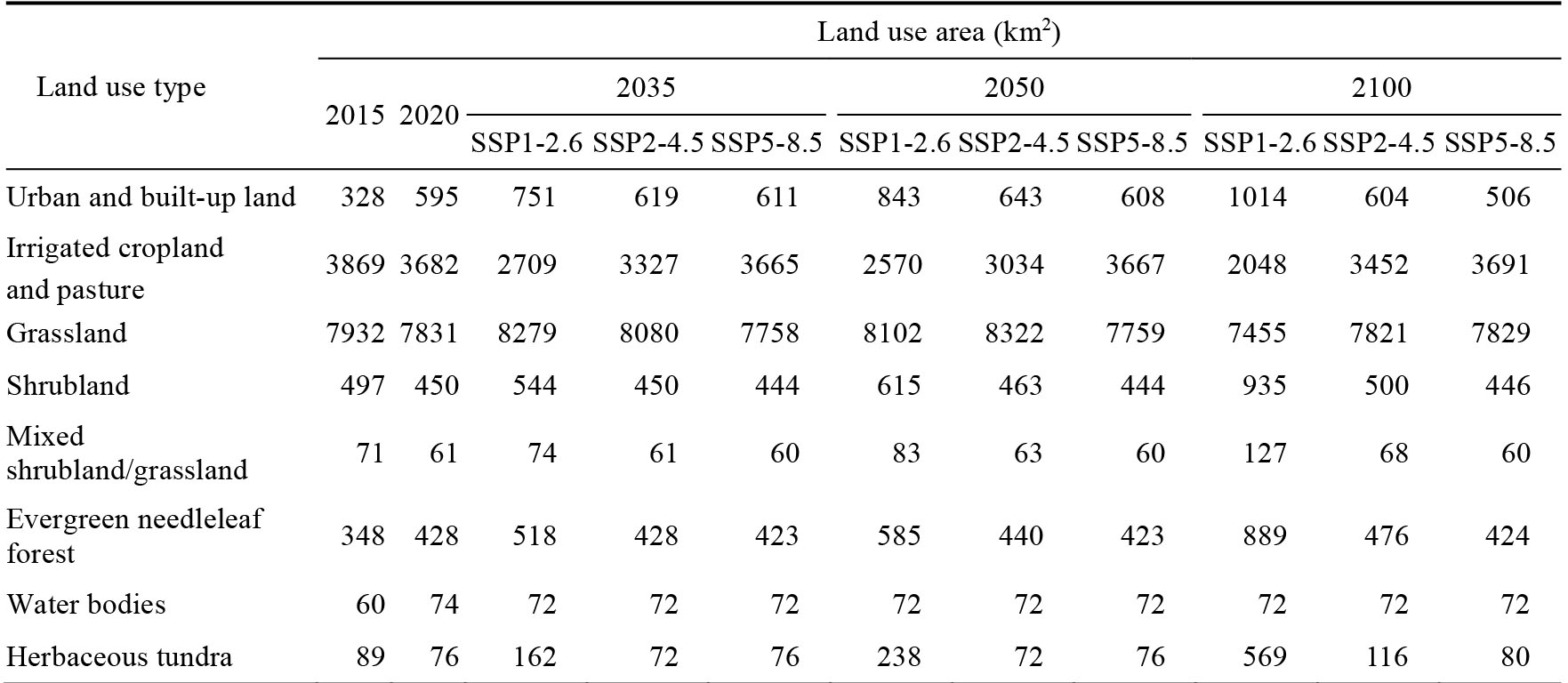
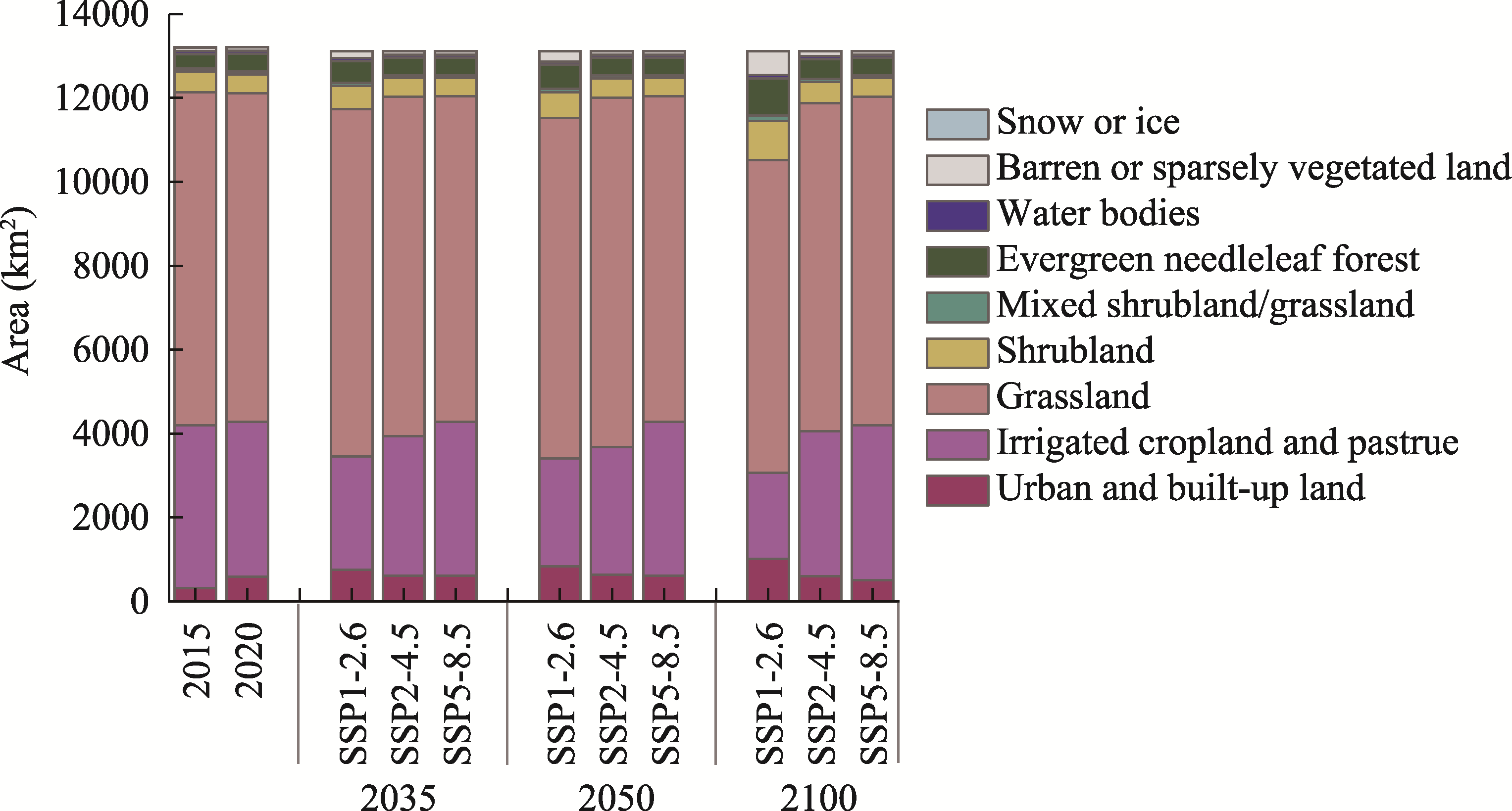
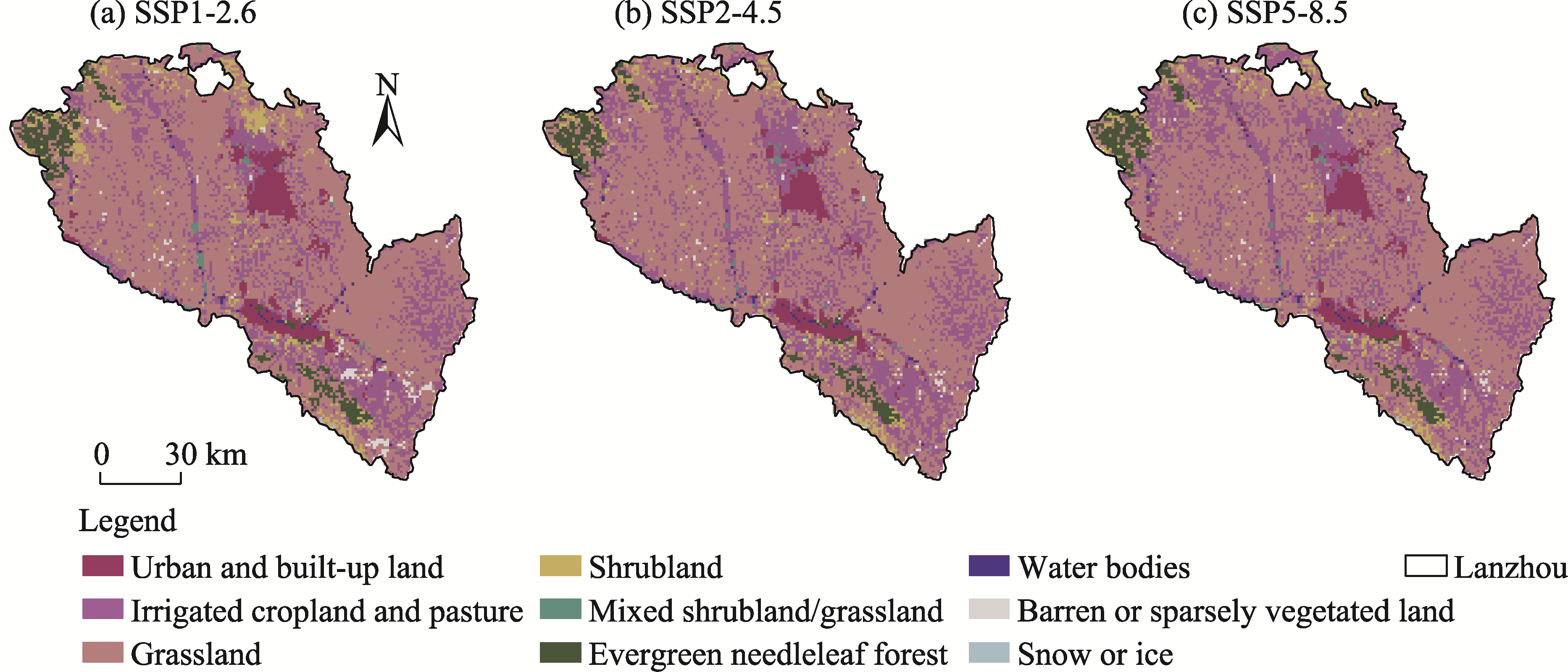
Abstract Land use in arid and semi-arid regions has a substantial effect on climate, environment, and biodiversity, thereby projecting the spatiotemporal changes in land use and the subsequent effects. This study employed the locally calibrated Future Land Use Simulation (FLUS) model, which coupled system dynamics with cellular automata and integrated an artificial neural network algorithm and a roulette wheel selection mechanism. We projected future land use (2020-2100) dynamics of Lanzhou, a typical river valley city in Northwest China, under three different Shared Socioeconomic Pathway (SSP) scenarios (SSP1-2.6, SSP2-4.5, and SSP5-8.5). The simulation results were validated and subsequently reclassified using the International Geosphere Biosphere Programme (IGBP) system to produce a dataset suitable for driving climatic and environmental models. Under the SSP1-2.6 scenario, urban and built-up land expanded consistently, whereas irrigated cropland and pasture as well as grassland contracted continuously. Conversely, the SSP5-8.5 scenario was characterized by a contraction of urban and built-up land, and relative stability of irrigated cropland and pasture as well as grassland. The SSP2-4.5 scenario presented a more complex trade-off, where urban and built-up land and grassland increased first and then decreased, whereas irrigated cropland and pasture followed an opposite trajectory. A significant inverse relationship between urban and built-up land and irrigated cropland and pasture was observed under all scenarios, underscoring the fundamental spatial competition that prevailed in this land-constrained valley city. Furthermore, the negative correlation of grassland with urban and built-up land, coupled with the positive correlation of grassland with irrigated cropland and pasture under both the SSP1-2.6 and SSP5-8.5 scenarios, indicated an evolution from broad confrontation to intricate internal trade-offs within the urban-agricultural-ecological system. This study underscored the critical influence of regional topographic and hydrological constraints on land-use evolution in arid regions, providing guidance for water resource management and ecosystem protection in Lanzhou, with applications for sustainable land-use planning in other arid and semi-arid river valley cities.
|
|
Received: 15 July 2025
Published: 31 January 2026
|
|
Corresponding Authors:
*JIANG Youyan (E-mail: jiangyouyan1981@163.com)
|
|
|
| [1] |
Bao Q L, Ding J L, Han L J, et al. 2022. Predicting land change trends and water consumption in typical arid regions using multi-models and multiple perspectives. Ecological Indicators, 141: 109110, doi: 10.1016/j.ecolind.2022.109110.
|
|
|
| [2] |
Best R H. 2024. Land Use and Living Space (2nd ed.). London: Routledge, 1-224.
|
|
|
| [3] |
Briassoulis H. 2020. Analysis of Land Use Change: Theoretical and Modeling Approaches (2nd ed.). Morgantown: West Virginia University, 1-247.
|
|
|
| [4] |
Bühne H S, Tobias J, Durant S, et al. 2021. Improving predictions of climate change-land use change interactions. Trends in Ecology & Evolution, 36(1): 29-38.
doi: 10.1016/j.tree.2020.08.019
|
|
|
| [5] |
Chen G Z, Li X, Liu X P, et al. 2020. Global projections of future urban land expansion under shared socioeconomic pathways. Nature Communications, 11(1): 537, doi: 10.1038/s41467-020-14386-x.
|
|
|
| [6] |
Chen W. 2024. National ecological security shield in the process of western region's large-scale development in the new era. Journal of South-Central Minzu University (Humanities and Social Sciences), 44(10): 89-101, 184-185. (in Chinese)
|
|
|
| [7] |
Dong N, You L, Cai W J, et al. 2018. Land use projections in China under global socioeconomic and emission scenarios: Utilizing a scenario-based land-use change assessment framework. Global Environmental Change, 50: 164-177.
doi: 10.1016/j.gloenvcha.2018.04.001
|
|
|
| [8] |
Feng H, Tang X L, Tao H J, et al. 2025. Ecological and environmental effects of river valley cities based on multi-scenario simulations of national land space: A case study of Lanzhou City. Environmental Science, 46(11): 7142-7155. (in Chinese)
doi: 10.1021/es204010g
|
|
|
| [9] |
Foley J, DeFries R, Asner G P, et al. 2005. Global consequences of land use. Science, 309(5734): 570-574.
doi: 10.1126/science.1111772
pmid: 16040698
|
|
|
| [10] |
Gao J, O'Neill B. 2020. Mapping global urban land for the 21st century with data-driven simulations and Shared Socioeconomic Pathways. Nature Communications, 11(1): 2302, doi: 10.1038/s41467-020-15788-7.
|
|
|
| [11] |
Gao L, Tao F, Liu R R, et al. 2022. Multi-scenario simulation and ecological risk analysis of land use based on the PLUS model: A case study of Nanjing. Sustainable Cities and Society, 85: 104055, doi: 10.1016/j.scs.2022.104055.
|
|
|
| [12] |
Gao Y T, Yu Y, Sun L X, et al. 2021. Land coverage change and driving forces of an oasis in the southern margin of Tarim Basin. Arid Zone Research, 38(4): 1172-1183. (in Chinese)
doi: 10.13866/j.azr.2021.04.29
|
|
|
| [13] |
Guo W, Teng Y J, Li J, et al. 2024. A new assessment framework to forecast land use and carbon storage under different SSP-RCP scenarios in China. Science of the Total Environment, 912: 169088, doi: 10.1016/j.scitotenv.2023.169088.
|
|
|
| [14] |
Han Q F, Luo G P, Li C F, et al. 2017. Modeling the grazing effect of grassland on the carbon source/sink in Xinjiang. Acta Ecologica Sinica, 37(13): 4392-4399. (in Chinese)
|
|
|
| [15] |
Hoffmann P, Reinhart V, Rechid D, et al. 2023. High-resolution land use and land cover dataset for regional climate modelling: Historical and future changes in Europe. Earth System Science Data, 15(9): 3819-3852.
doi: 10.5194/essd-15-3819-2023
|
|
|
| [16] |
Huang J P, Yu H P, Guan X D, et al. 2016. Accelerated dryland expansion under climate change. Nature Climate Change, 6(2): 166-171.
doi: 10.1038/NCLIMATE2837
|
|
|
| [17] |
Hurtt G C, Chini L, Sahajpal R, et al. 2020. Harmonization of global land-use change and management for the period 850-2100 (LUH2) for CMIP6. Geoscientific Model Development Discussions, 13: 5425-5464.
|
|
|
| [18] |
Intergovernmental Panel on Climate Change (IPCC). 2021. Climate Change 2021:The Physical Science Basis. Contribution of Working Group I to the Sixth Assessment Report of the Intergovernmental Panel on Climate Change. Cambridge, United Kingdom and New York, USA: Cambridge University Press.
|
|
|
| [19] |
Lal P, Shekhar A, Kumar A. 2021. Quantifying temperature and precipitation change caused by land cover change: a case study of India using the WRF model. Frontiers in Environmental Science, 9: 766328. doi: 10.3389/fenvs.2021.766328.
|
|
|
| [20] |
Landis J R, Koch G G. 1977. The measurement of observer agreement for categorical data. Biometrics, 33(1): 159-174.
pmid: 843571
|
|
|
| [21] |
Li S Y, Zhou Y Y, Yue D X, et al. 2024. Scenario simulation of ecosystem services based on land use/land cover change in the Bailong River Basin, in China. Land, 14(1): 25, doi: 10.3390/land14010025.
|
|
|
| [22] |
Liang X, Guan Q F, Clarke K C, et al. 2021. Understanding the drivers of sustainable land expansion using a patch-generating land use simulation (PLUS) model: A case study in Wuhan, China. Computers, Environment and Urban Systems, 85: 101569, doi: 10.1016/j.compenvurbsys.2020.101569.
|
|
|
| [23] |
Lin W B, Sun Y M, Nijhuis S, et al. 2020. Scenario-based flood risk assessment for urbanizing deltas using future land-use simulation (FLUS): Guangzhou Metropolitan Area as a case study. Science of the Total Environment, 739: 139899, doi: 10.1016/j.scitotenv.2020.139899.
|
|
|
| [24] |
Liu X, Liu H L. 2024. The application of ANN-FLUS model in reconstructing historical cropland distribution changes: A case study of Vietnam from 1885 to 2000. Journal of Natural Resources, 39(6): 1473-1492. (in Chinese)
doi: 10.31497/zrzyxb.20240613
|
|
|
| [25] |
Liu X P, Liang X, Li X, et al. 2017. A future land use simulation model (FLUS) for simulating multiple land use scenarios by coupling human and natural effects. Landscape and Urban Planning, 168: 94-116.
doi: 10.1016/j.landurbplan.2017.09.019
|
|
|
| [26] |
Liu X Q, Liu Y S, Wang Y S, et al. 2022. Evaluating potential impacts of land use changes on water supply-demand under multiple development scenarios in dryland region. Journal of Hydrology, 610: 127811, doi: 10.1016/j.jhydrol.2022.127811.
|
|
|
| [27] |
Long H L, Ma L, Zhou G P. 2025. Land use transition research in China: Progress, challenges and prospect. Acta Geographica Sinica, 80(8): 1993-2015. (in Chinese)
doi: 10.11821/dlxb202508001
|
|
|
| [28] |
Ma L, Hurtt G C, Chini L P, et al. 2020. Global rules for translating land-use change (LUH2) to land-cover change for CMIP6 using GLM2. Geoscientific Model Development, 13(7): 3203-3220.
doi: 10.5194/gmd-13-3203-2020
|
|
|
| [29] |
Manat A, Halik W, Halimulati G, et al. 2012. Assessment of residential environment suitability for southern Xinjiang based on GIS. Journal of Arid Land Resources and Environment, 26(4): 11-17. (in Chinese)
|
|
|
| [30] |
Meyer R, Zhang W M, Kragh S J, et al. 2022. Exploring the combined use of SMAP and Sentinel-1 data for downscaling soil moisture beyond the 1 km scale. Hydrology and Earth System Sciences Discussions, 26(13): 3337-3357.
|
|
|
| [31] |
Noszczyk T. 2019. A review of approaches to land use changes modeling. Human and Ecological Risk Assessment: An International Journal, 25(6): 1377-1405.
doi: 10.1080/10807039.2018.1468994
|
|
|
| [32] |
Parker D C, Manson S M, Janssen M A, et al. 2003. Multi-agent systems for the simulation of land-use and land-cover change: a review. Annals of the association of American Geographers, 93(2): 314-337.
doi: 10.1111/1467-8306.9302004
|
|
|
| [33] |
Pirani A, Fuglestvedt J S, Byers E, et al. 2024. Scenarios in IPCC assessments: Lessons from AR6 and opportunities for AR7. npj Climate Action, 3: 1, doi: 10.1038/s44168-023-00082-1.
|
|
|
| [34] |
Pongratz J, Schwingshackl C, Bultan S, et al. 2021. Land use effects on climate: current state, recent progress, and emerging topics. Current Climate Change Reports, 7: 99-120.
doi: 10.1007/s40641-021-00178-y
|
|
|
| [35] |
Pontius R G, Boersma W, Castella J C, et al. 2008. Comparing the input, output, and validation maps for several models of land change. The Annals of Regional Science, 42(1): 11-37.
doi: 10.1007/s00168-007-0138-2
|
|
|
| [36] |
Qiu Y, Feng J M, Yan Z W, et al. 2023. Assessing the land-use harmonization (LUH2) dataset in Central Asia for regional climate model projection. Environmental Research Letters, 18(6): 064008, doi: 10.1088/1748-9326/accfb2.
|
|
|
| [37] |
Riahi K, Van Vuuren D V, Kriegler E, et al. 2017. The Shared Socioeconomic Pathways and their energy, land use, and greenhouse gas emissions implications: An overview. Global Environmental Change, 42: 153-168.
doi: 10.1016/j.gloenvcha.2016.05.009
|
|
|
| [38] |
Şenik B, Kaya H S. 2022. Landscape sensitivity-based scenario analysis using flus model: a case of Asarsuyu watershed. Landscape and Ecological Engineering, 18(2): 139-156.
doi: 10.1007/s11355-021-00488-1
|
|
|
| [39] |
She W, Li Y, Zhong L H, et al. 2024. Hyperparameter optimization for neural network based on improved real coding genetic algorithm. Journal of Computer Applications, 44(3): 671-676. (in Chinese)
doi: 10.11772/j.issn.1001-9081.2023040441
|
|
|
| [40] |
Standardization Administration of China (SAC) and the General Administration of Quality Supervision, Inspection and Quarantine of China (AQSIQ). 2017. Current Land Use Classification Standard (GB/T 21010-2017). Beijing: Standards Press of China. (in Chinese)
|
|
|
| [41] |
Sun L, Yu H J, Sun M X, et al. 2023. Coupled impacts of climate and land use changes on regional ecosystem services. Journal of Environmental Management, 326: 116753, doi: 10.1016/j.jenvman.2022.116753.
|
|
|
| [42] |
Sun M M, Zhao X, Zhao J C, et al. 2024. A new spatial downscaling method for long-term AVHRR NDVI by multiscale residual Convolutional Neural Network. IEEE Journal of Selected Topics in Applied Earth Observations and Remote Sensing, 17: 7068-7088.
doi: 10.1109/JSTARS.2024.3373884
|
|
|
| [43] |
Sun S L, Zhang X P, Zhang Z B. 2021. Spatiotemporal changes and driving forces of landuse in Shaanxi Province during 2000-2018. Bulletin of Soil and Water Conservation, 41(4): 339-349. (in Chinese)
|
|
|
| [44] |
Wang F L. 2020. Land use change and simulation in Longnan City based on FLUS model. Master Thesis. Lanzhou: Northwest Normal University. (in Chinese)
|
|
|
| [45] |
Wang R. 2023. Analysis on land use change and landscape ecological risk in Gansu section of the mainstream of the Yellow River. Master Thesis. Lanzhou: Lanzhou University. (in Chinese)
|
|
|
| [46] |
Wang W J, Zhao Z K, Zhao D F. 2025. Analysis of the spatiotemporal pattern evolution of land use and carbon storage in the Yellow River Basin from 1980 to 2035 based on the FLUS-InVEST model. Ecological Economy, 41(8): 201-210. (in Chinese)
|
|
|
| [47] |
Wang X, Ma B W, Li D, et al. 2020. Multi-scenario simulation and prediction of ecological space in Hubei Province based on FLUS model. Journal of Natural Resources, 35(1): 230-242. (in Chinese)
doi: 10.31497/zrzyxb.20200119
|
|
|
| [48] |
Wang Z Y, Shi P J, Shi J, et al. 2023. Ecological effect of urban spatial expansion in river valleys: A case study in the main urban area of Lanzhou City. Resources Science, 45(12): 2385-2399. (in Chinese)
doi: 10.18402/resci.2023.12.07
|
|
|
| [49] |
Wei W, Shi P J, Feng H H, et al. 2012. Study on the suitability evaluation of the human settlement's environment in arid inland river basin—A case study on the Shiyang River basin. Journal of Natural Resources, 27(11): 1940-1950. (in Chinese)
|
|
|
| [50] |
Winkler K, Fuchs R, Rounsevell M, et al. 2021. Global land use changes are four times greater than previously estimated. Nature Communications, 12(1): 2501, doi: 10.1038/s41467-021-22702-2.
|
|
|
| [51] |
Wu J Y, Luo J G, Zhang H, et al. 2022. Projections of land use change and habitat quality assessment by coupling climate change and development patterns. Science of the Total Environment, 847: 157491, doi: 10.1016/j.scitotenv.2022.157491.
|
|
|
| [52] |
Wu K J, Wu M T, An Z H, et al. 2025. Evaluation of tourism ecological security and its obstacles in semi-arid river valley urban: a case study of Lanzhou, China. Scientific Reports, 15(1): 3943, doi: 10.1038/s41598-025-88157-3.
|
|
|
| [53] |
Wu X X, Liu X P, Liang X, et al. 2018. Multi-scenarios simulation of urban growth boundaries in Pearl River Delta based on FLUS-UGB. Journal of Geo-Information Science, 20(4): 532-542. (in Chinese)
|
|
|
| [54] |
Yang R H, Yang Q Y, Zeng L, et al. 2017. Evaluation on ecological security and analysis of influence factors of rural land based on BP-ANN model: A case study of Fengdu County in Chongqing. Research of Soil and Water Conservation, 24(3): 206-213. (in Chinese)
|
|
|
| [55] |
Yang Y, Zhang X Y, Su W, et al. 2024. Soil organic carbon storage and its influencing factors in farmland and desert ecosystems in Xinjiang. Acta Ecologica Sinica, 44(14): 6174-6185. (in Chinese)
|
|
|
| [56] |
Zhang C G, Fang C L. 2002. Driving mechanism analysis of ecological-economic-social capacity interactions in oasis systems of arid lands. Journal of Natural Resources, 17(2): 181-187. (in Chinese)
doi: 10.11849/zrzyxb.2002.02.009
|
|
|
| [57] |
Zhang M, Ma M G, De Maeyer P D, et al. 2017. Uncertainties in classification system conversion and an analysis of inconsistencies in global land cover products. ISPRS International Journal of Geo-Information, 6(4): 112, doi: 10.3390/ijgi6040112.
|
|
|
| [58] |
Zhao J C, Zhao X, Lian, S L, et al. 2020a. Assessing the thermal contributions of urban land cover types. Landscape and Urban Planning, 204: 103927, doi: 10.1016/j.landurbplan.2020.103927.
|
|
|
| [59] |
Zhao L F, Liu X P, Liu P H, et al. 2020b. Urban expansion simulation and early warning based on geographical partition and FLUS model. Journal of Geo-Information Science, 22(3): 517-530. (in Chinese)
|
|
|
| [60] |
Zheng J, Chen Z X, Wang Y, et al. 2005. Evaluation of urban human settlements development in Northwest China. Journal of Ningxia University (Natural Science Edition), 26(2): 171-175. (in Chinese)
|
|
|
| [61] |
Zhu R, Ao Z J, Jiang Y Y. 2024. Assessment of ecological environment vulnerability in Tianshui City based on the CRITIC objective weighting method. Journal of Desert Research, 44(3): 321-331. (in Chinese)
doi: 10.7522/j.issn.1000-694X.2024.00060
|
|
|
|
Viewed |
|
|
|
Full text
|
|
|
|
|
Abstract
|
|
|
|
|
Cited |
|
|
|
|
| |
Shared |
|
|
|
|
| |
Discussed |
|
|
|
|