| Research article |
|


|
|
|
| Glacial melting impact on runoff and evapotranspiration based on glacier-coupled SWAT model: A case study in the upper Shiyang River Basin, China |
CHU Jiangdong1,2, SU Xiaoling1,2,*( ), WANG Lei3, WU Nan4, Komelle ASKARI5, WU Haijiang1,2, ZHANG Te6, XU Liujia1,2, ZHANG Qifei7 ), WANG Lei3, WU Nan4, Komelle ASKARI5, WU Haijiang1,2, ZHANG Te6, XU Liujia1,2, ZHANG Qifei7 |
1 Key Laboratory of Agricultural Soil and Water Engineering in Arid and Semiarid Areas, Ministry of Education, Northwest A&F University, Yangling 712100, China
2 College of Water Resources and Architectural Engineering, Northwest A&F University, Yangling 712100, China
3 Shiyang River Basin Water Resources Utilization Center, Gansu Provincial Department of Water Resources, Wuwei 733000, China
4 College of Agricultural Science and Engineering, Hohai University, Nanjing 210098, China
5 State Key Laboratory of Soil Erosion and Dryland Farming on the Loess Plateau, Northwest A&F University, Yangling 712100, China
6 Three Gorges Digital Intelligence Institute, China Three Gorges University, Yichang 443002, China
7 School of Geographical Sciences, Shanxi Normal University, Taiyuan 030031, China |
|
|
|
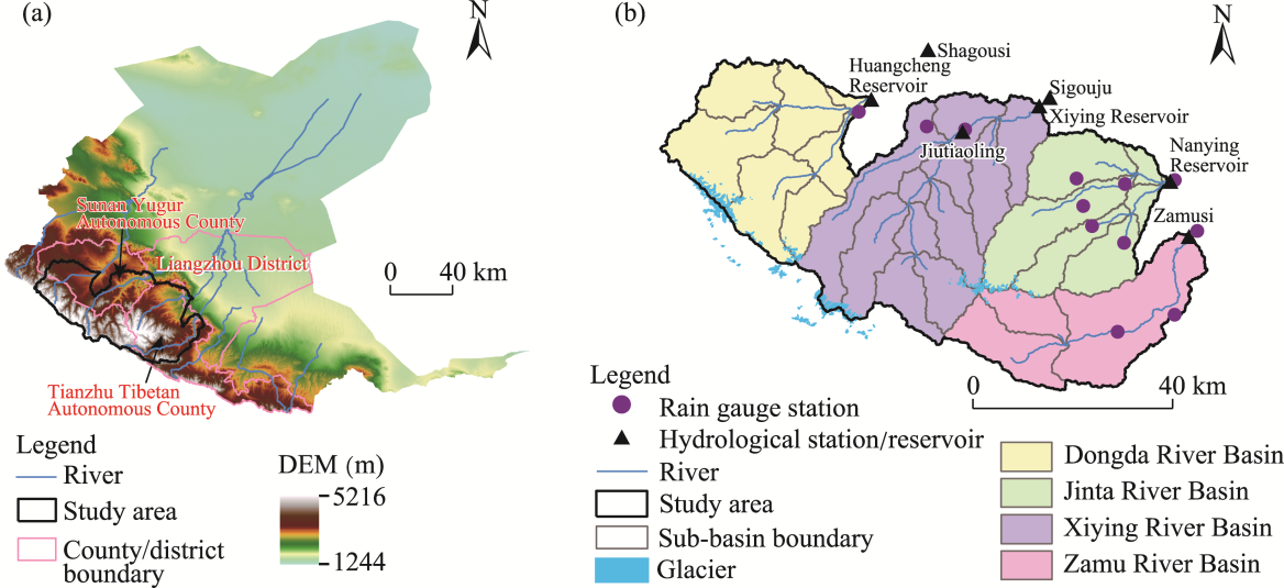
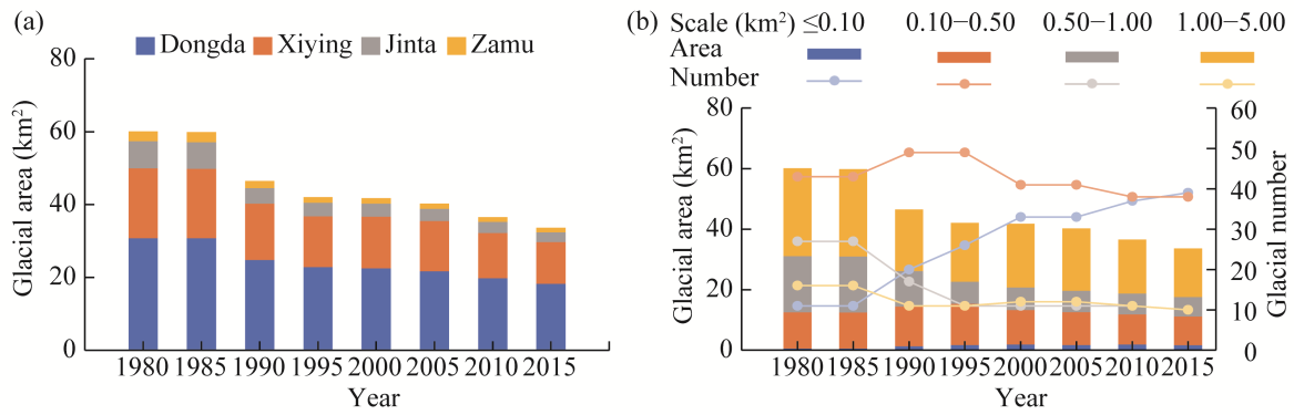
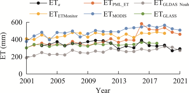
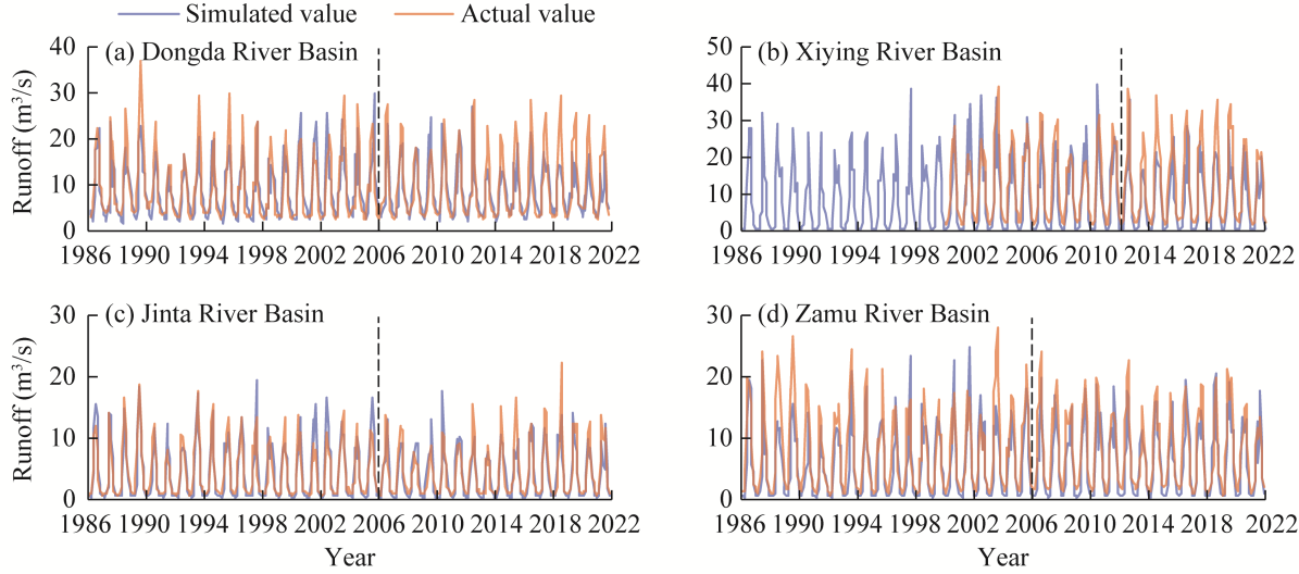
Abstract Glacial meltwater constitutes a vital component of the water supply in arid and semi-arid areas. However, the influence of glacial melting on runoff and evapotranspiration under global warming remains insufficiently understood. Previous studies coupling the Soil and Water Assessment Tool (SWAT) model with glacier modules often failed to consider the spatial heterogeneity of temperature during glacial melting, potentially leading to biased estimates of meltwater volume. In this study, we developed a glacier-coupled SWAT (SWAT-glacier) model considering the digital elevation model (DEM) based temperature-driven glacial melt processes to elucidate the impact of glacial melting on hydrological processes across four river basins (Dongda, Xiying, Jinta, and Zamu) of the upper Shiyang River Basin (SYRB) in northwestern China from 1986 to 2021. Compared with the standard SWAT model, the proposed SWAT-glacier model significantly improved the simulation accuracy for both runoff and evapotranspiration. Specifically, in comparison with the standard SWAT model, the Nash-Sutcliffe efficiency of the SWAT-glacier model showed a relative improvement of approximately 0.42%-9.16% and 1.50%-10.15% for runoff and evapotranspiration, respectively, in the four river basins during the validation period. Annual glacial runoff occurred predominantly from May to October, whereas glacial melt-induced evapotranspiration peaked between June and August. From 1986 to 2021, the average contributions of glacial melt to runoff were 6.97% for Dongda, 3.06% for Xiying, 2.70% for Jinta, and 0.67% for Zamu, whereas its contributions to evapotranspiration were 9.06%, 5.14%, 3.21%, and 1.59%, respectively. This study presents a SWAT-glacier modeling framework that enhances the simulation of hydrological processes in cold regions. The proposed methodology can be extended to other glacierized basins to provide valuable insights into water resource management under climate change.
|
|
Received: 28 April 2025
Published: 28 February 2026
|
|
Corresponding Authors:
*SU Xiaoling (E-mail: xiaolingsu@nwafu.edu.cn)
|
| Cite this article:
CHU Jiangdong, SU Xiaoling, WANG Lei, WU Nan, Komelle ASKARI, WU Haijiang, ZHANG Te, XU Liujia, ZHANG Qifei. Glacial melting impact on runoff and evapotranspiration based on glacier-coupled SWAT model: A case study in the upper Shiyang River Basin, China. Journal of Arid Land, 2026, 18(2): 216-234.
URL:
http://jal.xjegi.com/10.1016/j.jaridl.2025.08.001 OR http://jal.xjegi.com/Y2026/V18/I2/216
|
|
|
| [1] |
Adnan M, Kang S C, Zhang G S, et al. 2019. Evaluation of SWAT model performance on glaciated and non-glaciated subbasins of Nam Co Lake, Southern Tibetan Plateau, China. Journal of Mountain Science, 16(5): 1075-1097.
doi: 10.1007/s11629-018-5070-7
|
|
|
| [2] |
Afzal M M, Wang X L, Luo Y. 2025. Large glaciers sustaining the Upper Indus Basin glacier runoff in the future. Journal of Hydrology, 657: 132952, doi: 10.1016/j.jhydrol.2025.132952.
|
|
|
| [3] |
Bai H B, Zhong Y L, Ma N, et al. 2025. Changes and drivers of long-term land evapotranspiration in the Yangtze River Basin: A water balance perspective. Journal of Hydrology, 653: 132763, doi: 10.1016/j.jhydrol.2025.132763.
|
|
|
| [4] |
Banerjee A. 2022. A weak precipitation sensitivity of glacier runoff. Geophysical Research Letters, 49(5): e2021GL096989, doi: 10.1029/2021GL096989.
|
|
|
| [5] |
Beven K. 1993. Prophecy, reality and uncertainty in distributed hydrological modelling. Advances in Water Resources, 16(1): 41-51.
doi: 10.1016/0309-1708(93)90028-E
|
|
|
| [6] |
Bliss A, Hock R, Radić V. 2014. Global response of glacier runoff to twenty-first century climate change. Journal of Geophysical Research: Earth Surface, 119(4): 717-730.
doi: 10.1002/jgrf.v119.4
|
|
|
| [7] |
Brun F, Wagnon P, Berthier E, et al. 2019. Heterogeneous influence of glacier morphology on the mass balance variability in High Mountain Asia. Journal of Geophysical Research: Earth Surface, 124(6): 1331-1345.
doi: 10.1029/2018JF004838
|
|
|
| [8] |
Bureau of Statistics of Wuwei. 2016. Wuwei Statistical Yearbook 2016. Beijing: China Statistics Press. (in Chinese)
|
|
|
| [9] |
Bureau of Statistics of Zhangye. 2016. Zhangye Statistical Yearbook 2015. Beijing: China Statistics Press. (in Chinese)
|
|
|
| [10] |
Chen A A, Wang N L, Wu Y W, et al. 2020. Impact of glacier shape on the mass balance changes: A case study of Dongkemadi region, central Tibetan Plateau. Advances in Climate Change Research, 11(1): 22-30.
doi: 10.1016/j.accre.2020.05.010
|
|
|
| [11] |
Chen D H, Zou C, Wang S Y, et al. 2011. Study on spatial interpolation of the average temperature in the Yili River Valley based on DEM. Spectroscopy and Spectral Analysis, 31(7): 1925-1929. (in Chinese)
|
|
|
| [12] |
Chen H B, Wang T X, An J, et al. 2024a. Changes of glacier area in Kaidu River Basin and its contribution to runoff during melting seasons. Journal of China Hydrology, 44(3): 82-88. (in Chinese)
|
|
|
| [13] |
Chen L F, Zhang Z J, Liu C Q, et al. 2024b. Incorporating glacier processes into hydrological simulations in the headwaters of the Yangtze and Yellow Rivers. Science of The Total Environment, 951: 175474, doi: 10.1016/j.scitotenv.2024.175474.
|
|
|
| [14] |
Chen L H, Qu Y G. 1992. Soil and Water Resources and their Rational Development and Utilization in Hexi Region. Beijing: Science Press, 45. (in Chinese)
|
|
|
| [15] |
Chen X, Long D, Hong Y, et al. 2017. Improved modeling of snow and glacier melting by a progressive two‐stage calibration strategy with GRACE and multisource data: How snow and glacier meltwater contributes to the runoff of the Upper Brahmaputra River basin? Water Resources Research, 53(3): 2431-2466.
doi: 10.1002/wrcr.v53.3
|
|
|
| [16] |
Chu J D, Su X L, Jiang T L, et al. 2023a. Filling the gap between GRACE and GRACE-FO data using a model integrating variational mode decomposition and long short-term memory: a case study of Northwest China. Environmental Earth Sciences, 82(1): 38, doi: 10.1007/s12665-022-10716-y.
|
|
|
| [17] |
Chu J D, Su X L, Wu H J, et al. 2023b. Analysis of terrestrial water storage and its component changes in China from 2002 to 2021. Water Resources Protection, 39(3): 170-178. (in Chinese)
|
|
|
| [18] |
Dai J, Hu H Z, Mao X M, et al. 2025. Projected alterations in snowmelt streamflow with climate change in Shiyang River Basin of Northwest China using modified SWAT model. CATENA, 252: 108884, doi: 10.1016/j.catena.2025.108884.
|
|
|
| [19] |
Fang G H, Yang J, Chen Y N, et al. 2018. How hydrologic processes differ spatially in a large basin: multisite and multiobjective modeling in the Tarim River Basin. Journal of Geophysical Research: Atmospheres, 123(14): 7098-7113.
doi: 10.1029/2018JD028423
|
|
|
| [20] |
Frenierre J L, Mark B G. 2014. A review of methods for estimating the contribution of glacial meltwater to total watershed discharge. Progress in Physical Geography: Earth and Environment, 38(2): 173-200.
doi: 10.1177/0309133313516161
|
|
|
| [21] |
Gao X, Ye B S, Zhang S Q, et al. 2010. Glacier runoff variation and its influence on river runoff during 1961-2006 in the Tarim River Basin, China. Science China Earth Sciences, 53(6): 880-891.
doi: 10.1007/s11430-010-0073-4
|
|
|
| [22] |
Gu H H, Liu Y Q, Wang X Y, et al. 2024. Hydrology simulation and glacier runoff study in Lhasa River Basin based on VIC_glacier model. Journal of China Hydrology, 44(1): 90-95, 103. (in Chinese)
|
|
|
| [23] |
Han P F, Long D, Zhao F Y, et al. 2023. Response of two glaciers in different climate settings of the Tibetan Plateau to climate change through year 2100 using a hybrid modeling approach. Water Resources Research, 59(4): e2022WR033618, doi: 10.1029/2022WR033618.
|
|
|
| [24] |
Hock R. 2003. Temperature index melt modelling in mountain areas. Journal of Hydrology, 282(1-4): 104-115.
doi: 10.1016/S0022-1694(03)00257-9
|
|
|
| [25] |
Hu L T, Wang Z J, Tian W. 2013. Research on Integrated Modeling and Application of Surface Water and Groundwater in Arid Inland River Areas. Beijing: China Water Conservancy and Hydropower Press, 66-72. (in Chinese)
|
|
|
| [26] |
Jia Y F, Li Z Q, Gao H K, et al. 2024. Hydrological response to climate change in a glacierized catchment in eastern Tien Shan, Central Asia. Journal of Hydrology: Regional Studies, 51: 101669, doi: 10.1016/j.ejrh.2024.101669.
|
|
|
| [27] |
Jin X, Jin Y X, Mao X F, et al. 2023. Impact of increasing vegetation coverage on gaining and losing streams in an arid endorheic river watershed. Hydrological Processes, 37(12): e15062, doi: 10.1002/hyp.15062.
|
|
|
| [28] |
Jones J A A. 1999. Climate change and sustainable water resources: placing the threat of global warming in perspective. Hydrological Sciences Journal, 44(4): 541-557.
doi: 10.1080/02626669909492251
|
|
|
| [29] |
Ju Q, Liu X N, Liu D, et al. 2024. Spatiotemporal variation characteristics of actual evapotranspiration based on remote sensing and flux observations: case study in the water conservation area of the Yellow River basin. Advances in Water Science, 35(2): 338-347. (in Chinese)
|
|
|
| [30] |
Khanal P, van Dijke A J H, Schaffhauser T, et al. 2024. Relevance of near-surface soil moisture vs. terrestrial water storage for global vegetation functioning. Biogeosciences, 21(6): 1533-1547.
doi: 10.5194/bg-21-1533-2024
|
|
|
| [31] |
Khatakho R, Firoz A, Elagib N A, et al. 2024. Hydrological modelling using gridded and ground-based precipitation datasets in data-scarce mountainous regions. Hydrological Processes, 38(12): e70024, doi: 10.1002/hyp.70024.
|
|
|
| [32] |
Li H Y, Zhao Q D, Wu J K, et al. 2019a. Quantitative simulation of the runoff components and its variation characteristics in the upstream of the Shule River. Journal of Glaciology and Geocryology, 41(4): 907-917. (in Chinese)
|
|
|
| [33] |
Li J, Wang Y Z, Li J J. 2019b. Glacier outlines over the Qilian Mountain area (1980-2015). National Tibetan Plateau, doi: 10.11888/Geogra.tpdc.270234. (in Chinese)
|
|
|
| [34] |
Li K J. 2022. Modern glacier changes and influence on runoff based on modelling in Qilian Mountains. MSc Thesis. Lanzhou: Lanzhou University, 38. (in Chinese)
|
|
|
| [35] |
Li S M, Cheng G D, Li Y H, et al. 2002. Rational Utilization of Water Resources and Ecological Environment Protection in Hexi Corridor. Zhengzhou: Yellow River Water Conservancy Press, 9. (in Chinese)
|
|
|
| [36] |
Li T, Zhao J X, Wu G L. 2025. Glaciers retreat-induced gravelization encroached alpine hillside grassland: A case study in Qilian Mountain, China. CATENA, 254: 108905, doi: 10.1016/j.catena.2025.108905.
|
|
|
| [37] |
Liang W T, Chen Y N, Fang G H, et al. 2023. Machine learning method is an alternative for the hydrological model in an alpine catchment in the Tianshan region, Central Asia. Journal of Hydrology: Regional Studies, 49: 101492, doi: 10.1016/j.ejrh.2023.101492.
|
|
|
| [38] |
Liu G H, Chen R S, Li K L. 2021. Glacial change and its hydrological response in three inland river basins in the Qilian Mountains, Western China. Water, 13(16): 2213, doi: 10.3390/w13162213.
|
|
|
| [39] |
Liu J, Long A H, Deng X Y, et al. 2022. The impact of climate change on hydrological processes of the glacierized watershed and projections. Remote Sensing, 14(6): 1314, doi: 10.3390/rs14061314.
|
|
|
| [40] |
Luo Y, Arnold J, Liu S Y, et al. 2013. Inclusion of glacier processes for distributed hydrological modeling at basin scale with application to a watershed in Tianshan Mountains, Northwest China. Journal of Hydrology, 477: 72-85.
doi: 10.1016/j.jhydrol.2012.11.005
|
|
|
| [41] |
Merk F, Schaffhauser T, Anwar F, et al. 2024. The significance of the leaf area index for evapotranspiration estimation in SWAT-T for characteristic land cover types of West Africa. Hydrology and Earth System Sciences, 28(24): 5511-5539.
doi: 10.5194/hess-28-5511-2024
|
|
|
| [42] |
Pascolini-Campbell M A, Reager J T, Fisher J B, et al. 2020. GRACE-based mass conservation as a validation target for basin-scale evapotranspiration in the contiguous United States. Water Resources Research, 56(2): e2019WR026594, doi: 10.1029/2019WR026594.
|
|
|
| [43] |
People's Government of Wuwei City. 2019. Wuwei Municipal Water Use Quota Standards (2019). [2024-09-21]. https://www.gswuwei.gov.cn/art/2019/3/9/art_1144_241443.html.
|
|
|
| [44] |
Schaffhauser T, Garijo D, Osorio M, et al. 2023. A framework for the broad dissemination of hydrological models for non-expert users. Environmental Modelling & Software, 164: 105695, doi: 10.1016/j.envsoft.2023.105695.
|
|
|
| [45] |
Schaffhauser T, Tuo Y, Hofmeister F, et al. 2024. SWAT-GL: A new glacier routine for the hydrological model SWAT. Journal of the American Water Resources Association, 60(3): 755-766.
doi: 10.1111/jawr.v60.3
|
|
|
| [46] |
Sharma A, Patel P L, Sharma P J. 2022. Influence of climate and land-use changes on the sensitivity of SWAT model parameters and water availability in a semi-arid river basin. CATENA, 215: 106298, doi: 10.1016/j.catena.2022.106298.
|
|
|
| [47] |
Su J W, Long A H, Chen F L, et al. 2023. Impact of the construction of water conservation projects on runoff from the Weigan River. Water, 15(13): 2431, doi: 10.3390/w15132431.
|
|
|
| [48] |
Wang J L, Li Y N, Du M Y, et al. 2009. The features of microclimate and vegetation distribution on the southern Lenglongling, Qilian Mountains. Journal of Mountain Science, 27(4): 418-426. (in Chinese)
|
|
|
| [49] |
Wang P Y, Li Z Q, Xu C H, et al. 2017a. Multi-decadal variations in glacier flow velocity and the influencing factors of Urumqi Glacier No. 1 in Tianshan Mountains, Northwest China. Journal of Arid Land, 9(6): 900-910.
doi: 10.1007/s40333-017-0067-6
|
|
|
| [50] |
Wang R, Yao Z J, Wu S S, et al. 2017b. Glacier retreat and its impact on summertime run-off in a high-altitude ungauged catchment. Hydrological Processes, 31(21): 3672-3681.
doi: 10.1002/hyp.v31.21
|
|
|
| [51] |
Wang Y H, Yang H B, Yang D W, et al. 2017c. Spatial interpolation of daily precipitation in a high mountainous watershed based on gauge observations and a regional climate model simulation. Journal of Hydrometeorology, 18(3): 845-862.
doi: 10.1175/JHM-D-16-0089.1
|
|
|
| [52] |
Wang Y J, Yu D Y, Zhou Z Y. 2024a. Review of research progress and modeling of hydrological processes in the cold regions of the Qinghai-Xizang Plateau. Journal of Glaciology and Geocryology, 46(4): 1312-1328. (in Chinese)
|
|
|
| [53] |
Wang Y Y, Li Z X, Xue J, et al. 2024b. Moisture conditions are limiting evapotranspiration changes of Alpine mountains of Qilian Mountains. Hydrological Processes, 38(9): e15256, doi: 10.1002/hyp.15256.
|
|
|
| [54] |
Wei X N, Long A H, Yin Z L, et al. 2022. Simulation of response of glacier runoff to climate change in the Hotan River Basin. Water Resources Protection, 38(4): 137-144. (in Chinese)
|
|
|
| [55] |
Wiersma P, Aerts J, Zekollari H, et al. 2022. Coupling a global glacier model to a global hydrological model prevents underestimation of glacier runoff. Hydrology and Earth System Sciences, 26(23): 5971-5986.
doi: 10.5194/hess-26-5971-2022
|
|
|
| [56] |
World Meteorological Organization. 2025. State of the Global Climate 2024. Geneva: World Meteorological Organization: 42.
|
|
|
| [57] |
Wu F, Zhan J Y, Wang Z, et al. 2015. Streamflow variation due to glacier melting and climate change in upstream Heihe River Basin, Northwest China. Physics and Chemistry of the Earth, Parts A/B/C, 79-82: 11-19.
doi: 10.1016/j.pce.2014.08.002
|
|
|
| [58] |
Wu H J, Su X L, Huang S Z, et al. 2025. Decreasing dynamic predictability of global agricultural drought with warming climate. Nature Climate Change, 15: 411-419.
|
|
|
| [59] |
Wu J, Gao X J. 2013. A gridded daily observation dataset over China region and comparison with the other datasets. Chinese Journal of Geophysics, 56(4): 1102-1111. (in Chinese)
|
|
|
| [60] |
Wu J K, Li H Y, Zhou J X, et al. 2021. Variation of runoff and runoff components of the Upper Shule River in the northeastern Qinghai-Tibet Plateau under climate change. Water, 13(23): 3357, doi: 10.3390/w13233357.
|
|
|
| [61] |
Xu M, Wang P S, Wu H, et al. 2023. Different patterns of changes in glacier mass balance and glacier runoff over the Tarim Basin, Central Asia. Hydrological Processes, 37(10): e14997, doi: 10.1002/hyp.14997.
|
|
|
| [62] |
Xu M, Wang P S, Zhang X, et al. 2025. Impacts of glacier shrinkage on peak melt runoff at the sub-basin scale of Northwest China. Journal of Hydrology, 654: 132953, doi: 10.1016/j.jhydrol.2025.132953.
|
|
|
| [63] |
Yang C D, Xu M, Fu C S, et al. 2022. The coupling of glacier melt module in SWAT+ model based on multi-source remote sensing data: a case study in the Upper Yarkant River Basin. Remote Sensing, 14(23): 6080, doi: 10.3390/rs14236080.
|
|
|
| [64] |
Yin Z L, Feng Q, Liu S Y, et al. 2017. The spatial and temporal contribution of glacier runoff to watershed discharge in the Yarkant River Basin, Northwest China. Water, 9(3): 159, doi: 10.3390/w9030159.
|
|
|
| [65] |
Zemp M, Jakob L, Dussaillant I, et al. 2025. Community estimate of global glacier mass changes from 2000 to 2023. Nature, 639: 382-388.
doi: 10.1038/s41586-024-08545-z
|
|
|
| [66] |
Zhang G X, Su X L, Ayantobo O O, et al. 2020. Remote-sensing precipitation and temperature evaluation using soil and water assessment tool with multiobjective calibration in the Shiyang River Basin, Northwest China. Journal of Hydrology, 590: 125416, doi: 10.1016/j.jhydrol.2020.125416.
|
|
|
| [67] |
Zhang G X, Su X L, Ayantobo O O, et al. 2021. Spatial interpolation of daily precipitation based on modified ADW method for gauge-scarce mountainous regions: A case study in the Shiyang River Basin. Atmospheric Research, 247: 105167, doi: 10.1016/j.atmosres.2020.105167.
|
|
|
| [68] |
Zhang H. 2022. Variations of glacier mass balance and its contribution to mountain runoff across the northern Qilian Mountains. MSc Thesis. Lanzhou: Northwest Normal University, 21-22. (in Chinese)
|
|
|
| [69] |
Zhang J, Xu C C, Wang H Y, et al. 2025. Runoff simulation and hydropower resource prediction of the Kaidu River Basin in the Tianshan Mountains, China. Journal of Arid Land, 17(1): 1-18.
doi: 10.1007/s40333-025-0071-1
|
|
|
| [70] |
Zhang J T, He X J, Shangguan D H, et al. 2012. Impact of intensive glacier ablation on arid regions of Northwest China and its countermeasure. Journal of Glaciology and Geocryology, 34(4): 848-854. (in Chinese)
|
|
|
| [71] |
Zhang S Q, Gao X, Zhang X W. 2015. Glacial runoff likely reached peak in the mountainous areas of the Shiyang River Basin, China. Journal of Mountain Science, 12(2): 382-395.
doi: 10.1007/s11629-014-3077-2
|
|
|
| [72] |
Zhao Q D, Ding Y J, Wang J, et al. 2019. Projecting climate change impacts on hydrological processes on the Tibetan Plateau with model calibration against the glacier inventory data and observed streamflow. Journal of Hydrology, 573: 60-81.
doi: 10.1016/j.jhydrol.2019.03.043
|
|
|
| [73] |
Zhu X Y, Su X L, Singh V P, et al. 2025. Improving synergy of the water-agriculture-ecology system in arid areas using a novel co-optimization model. Agricultural Water Management, 312: 109408, doi: 10.1016/j.agwat.2025.109408.
|
|
|
| [74] |
Zou R, Wang X J, Yin Y X, et al. 2024. Comparing spatio-temporal propagation patterns of hydrological and meteorological droughts: Insights from SWAT modelling in the Poyang Lake Basin. CATENA, 243: 108183, doi: 10.1016/j.catena.2024.108183.
|
|
|
|
Viewed |
|
|
|
Full text
|
|
|
|
|
Abstract
|
|
|
|
|
Cited |
|
|
|
|
| |
Shared |
|
|
|
|
| |
Discussed |
|
|
|
|