| Research article |
|

|
|
|
| Landscape ecological risk assessment and its driving factors in the Weihe River basin, China |
CHANG Sen, WEI Yaqi, DAI Zhenzhong, XU Wen, WANG Xing, DUAN Jiajia, ZOU Liang, ZHAO Guorong, REN Xiaoying, FENG Yongzhong*( ) ) |
| College of Agronomy, Northwest A&F University, Yangling 712100, China |
|
|
|
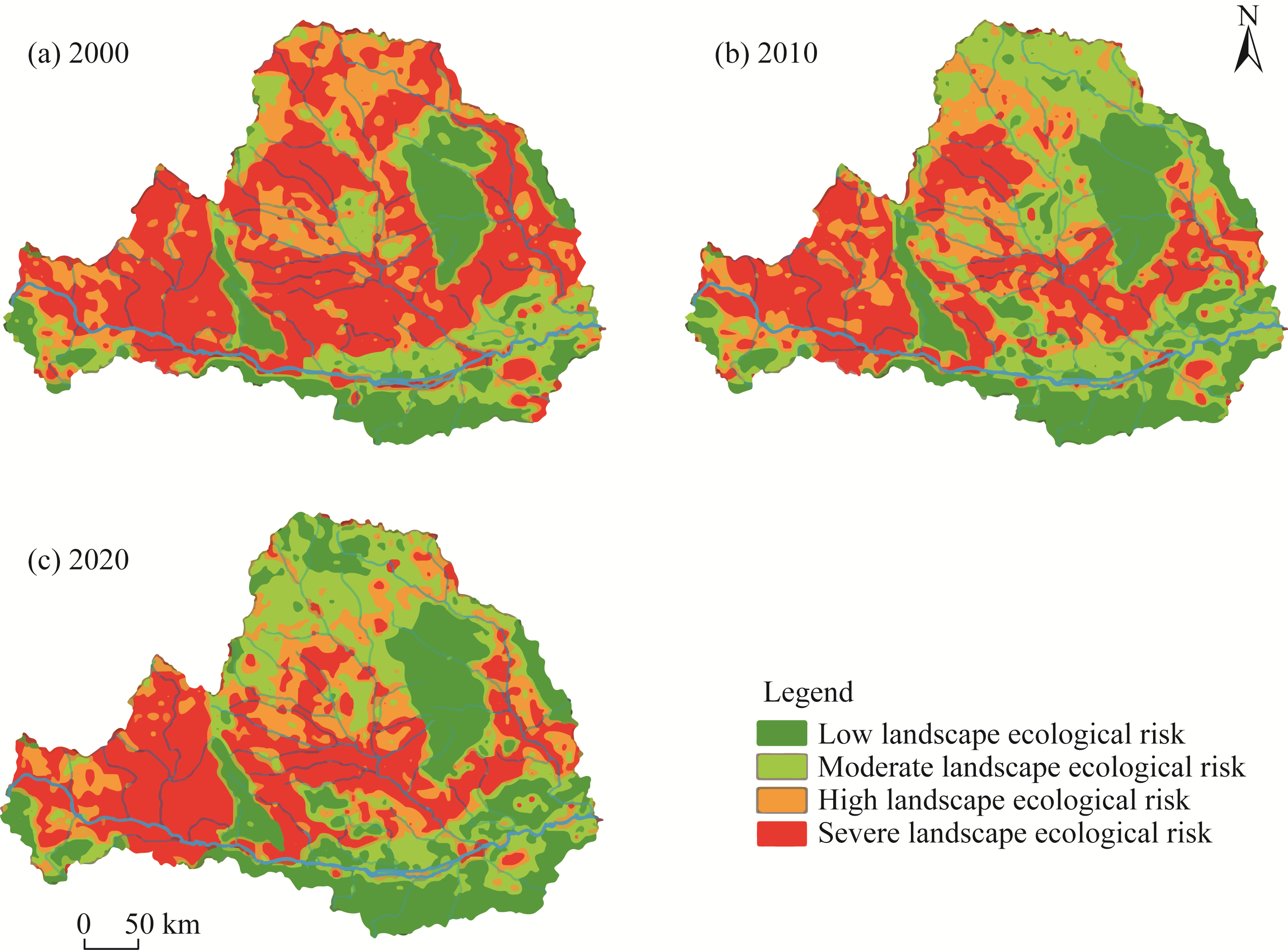
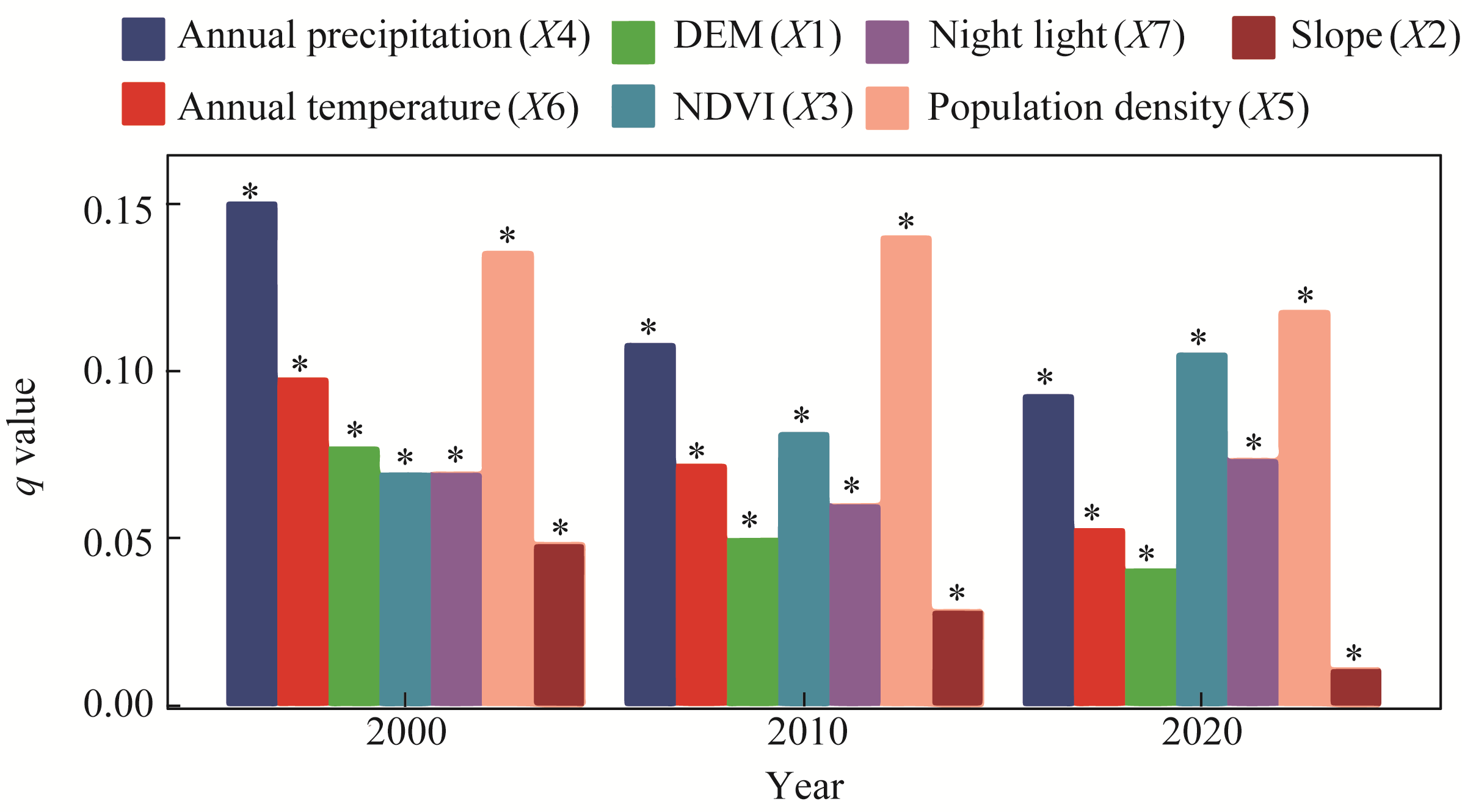
Abstract Weihe River basin is of great significance to analyze the changes of land use pattern and landscape ecological risk and to improve the ecological basis of regional development. Based on land use data of the Weihe River basin in 2000, 2010, and 2020, with the support of Aeronautical Reconnaissance Coverage Geographic Information System (ArcGIS), GeoDa, and other technologies, this study analyzed the spatial-temporal characteristics and driving factors of land use pattern and landscape ecological risk. Results showed that land use structure of the Weihe River basin has changed significantly, with the decrease of cropland and the increase of forest land and construction land. In the past 20 a, cropland has decreased by 7347.70 km2, and cropland was mainly converted into forest land, grassland, and construction land. The fragmentation and dispersion of ecological landscape pattern in the Weihe River basin were improved, and land use pattern became more concentrated. Meanwhile, landscape ecological risk of the Weihe River basin has been improved. Severe landscape ecological risk area decreased by 19,177.87 km2, high landscape ecological risk area decreased by 3904.35 km2, and moderate and low landscape ecological risk areas continued to increase. It is worth noting that landscape ecological risks in the upper reaches of the Weihe River basin are still relatively serious, especially in the contiguous areas of high ecological risk, such as Tianshui, Pingliang, Dingxi areas and some areas of Ningxia Hui Autonomous Region. Landscape ecological risk showed obvious spatial dependence, and high ecological risk area was concentrated. Among the driving factors, population density, precipitation, normalized difference vegetation index (NDVI), and their interactions are the most important factors affecting the landscape ecological risk of the Weihe River basin. The findings significantly contribute to our understanding of the ecological dynamics in the Weihe River basin, providing crucial insights for sustainable management in the region.
|
|
Received: 08 December 2023
Published: 31 May 2024
|
|
Corresponding Authors:
*FENG Yongzhong (E-mail: fengyz@nwsuaf.edu.cn)
|
| Cite this article:
CHANG Sen, WEI Yaqi, DAI Zhenzhong, XU Wen, WANG Xing, DUAN Jiajia, ZOU Liang, ZHAO Guorong, REN Xiaoying, FENG Yongzhong. Landscape ecological risk assessment and its driving factors in the Weihe River basin, China. Journal of Arid Land, 2024, 16(5): 603-614.
URL:
http://jal.xjegi.com/10.1007/s40333-024-0013-3 OR http://jal.xjegi.com/Y2024/V16/I5/603
|
|
|
| [1] |
Anselin L. 1995. Local indicators of spatial association—LISA. Geographical Analysis, 27(2): 93-115.
|
|
|
| [2] |
Chang S, Dai Z, Wang X, et al. 2023. Landscape pattern identification and ecological risk assessment employing land use dynamics on the Loess Plateau. Agronomy-Basel, 13(9): 2247, doi: 10.3390/agronomy13092247.
|
|
|
| [3] |
Chen H, Zhao Y, Fu X, et al. 2022a. Impacts of regional land-use patterns on ecosystem services in the typical agro-pastoral ecotone of northern China. Ecosystem Health and Sustainability, 8(1): 2110521, doi: 10.1080/20964129.2022.2110521.
|
|
|
| [4] |
Chen H, Zhou D, Zhang J, et al. 2022b. Ecological risk assessment of Gansu section of Weihe River Basin based on landscape pattern. Agricultural Engineering, 12(11): 72-79. (in Chinese)
|
|
|
| [5] |
Chen J, Dong B, Li H, et al. 2020. Study on landscape ecological risk assessment of hooded crane breeding and overwintering habitat. Environmental Research, 187: 109649, doi: 10.1016/j.envres.2020.109649.
|
|
|
| [6] |
Chen Y, Li H, Karimian H, et al. 2022c. Spatio-temporal variation of ozone pollution risk and its influencing factors in China based on Geodetector and Geospatial models. Chemosphere, 302: 134843, doi: 10.1016/j.chemosphere.2022.134843.
|
|
|
| [7] |
He C, Pu J, Shen J. 2020. Spatial-temporal changes and driving mechanisms of landscape ecological security in lower reaches of Lancang River during 2005-2018. Bulletin of Soil and Water Conservation, 40(4): 219-227. (in Chinese)
|
|
|
| [8] |
Huang M Y, He X. 2016. Landscape ecological risk assessment and its mechanism in Chaohu Basin during the past almost 20 years. Journal of Lake Sciences, 28(4): 785-793.
|
|
|
| [9] |
Karimian H, Chen Y, Tao T, et al. 2020. Spatiotemporal analysis of air quality and its relationship with meteorological factors in the Yangtze River Delta. Journal of Elementology, 25(3): 1059-1075.
|
|
|
| [10] |
Kim S, Kwak J, Yoon J, et al. 2014. Selection of domestic test species suitable for Korean soil ecological risk assessment. Journal of Korean Society of Environmental Engineers, 36(5): 359-366.
|
|
|
| [11] |
Li Q, Zhang Z, Wan L, et al. 2019. Landscape pattern optimization in Ningjiang River Basin based on landscape ecological risk assessment. Acta Geographica Sinica, 74(7): 1420-1437. (in Chinese)
doi: 10.11821/dlxb201907011
|
|
|
| [12] |
Liu C, Zhang K, Liu J. 2018. A long-term site study for the ecological risk migration of landscapes and its driving forces in the Sanjiang Plain from 1976 to 2013. Acta Ecologica Sinica, 38(11): 3729-3740. (in Chinese)
|
|
|
| [13] |
Liu D, Chen H, Zhang H, et al. 2020. Spatiotemporal evolution of landscape ecological risk based on geomorphological regionalization during 1980-2017: A case study of Shaanxi Province, China. Sustainability, 12(3): 941, doi: 10.3390/su12030941.
|
|
|
| [14] |
Mishra A, Humpenoder F, Churkina G, et al. 2022. Land use change and carbon emissions of a transformation to timber cities. Nature Communications, 13(1): 4889, doi: 10.1038/s41467-022-32244-w.
pmid: 36042197
|
|
|
| [15] |
Mo Y, Li Q, Karimian H, et al. 2021. Daily spatiotemporal prediction of surface ozone at the national level in China: An improvement of CAMS ozone product. Atmospheric Pollution Research, 12(1): 391-402.
|
|
|
| [16] |
Moussa Kourouma J, Phiri D, Hudak A T, et al. 2022. Land use/cover spatiotemporal dynamics, and implications on environmental and bioclimatic factors in Chingola District, Zambia. Geomatics, Natural Hazards and Risk, 13(1): 1898-1942.
|
|
|
| [17] |
Peng J, Zong M, Hu Y, et al. 2015. Assessing landscape ecological risk in a Mining City: A case study in Liaoyuan City, China. Sustainability, 7(7): 8312-8334.
|
|
|
| [18] |
Song W, Pijanowski B. 2014. The effects of China's cultivated land balance program on potential land productivity at a national scale. Applied Geography, 46: 158-170.
|
|
|
| [19] |
Tang L, Ma W. 2018. Assessment and management of urbanization-induced ecological risks. International Journal of Sustainable Development and World Ecology, 25(5): 383-386.
|
|
|
| [20] |
Tian P, Li J, Gong H, et al. 2019. Research on land use changes and ecological risk assessment in Yongjiang River basin in Zhejiang Province, China. Sustainability, 11(10): 2817, doi: 10.3390/su11102817.
|
|
|
| [21] |
Wang B, Ding M, Li S, et al. 2020. Assessment of landscape ecological risk for a cross-border basin: A case study of the Koshi River Basin, central Himalayas. Ecological Indicators, 117: 106621, doi: 10.1016/j.ecolind.2020.106621.
|
|
|
| [22] |
Wang J, Xu C. 2017. Geographical detector: Principle and prospect. Acta Geographica Sinica, 72(1): 27-116. (in Chinese)
|
|
|
| [23] |
Wang S, Liu F, Chen W, et al. 2024. Landscape ecological risk evaluation and driving factors in the lake basin of central Yunnan Plateau. Chinese Journal of Eco-Agriculture, 32(3): 391-404. (in Chinese)
|
|
|
| [24] |
Wang X, Adamowski J F, Wang G, et al. 2019. Farmers' willingness to accept compensation to maintain the benefits of urban forests. Forests, 10(8): 691, doi: 10.3390/f10080691.
|
|
|
| [25] |
Xiang J, Li X, Xiao R, et al. 2021. Effects of land use transition on ecological vulnerability in poverty-stricken mountainous areas of China: A complex network approach. Journal of Environmental Management, 297: 113206, doi: 10.1016/j.jenvman.2021.113206.
|
|
|
| [26] |
Xie H, Wang P, Huang H. 2013. Ecological risk assessment of land use change in the Poyang Lake eco-economic zone, China. International Journal of Environmental Research and Public Health, 10(1): 328-346.
doi: 10.3390/ijerph10010328
pmid: 23343986
|
|
|
| [27] |
Xing L, Hu M, Wang Y. 2020. Integrating ecosystem services value and uncertainty into regional ecological risk assessment: A case study of Hubei Province, Central China. Science of the Total Environment, 740: 140126, doi: 10.1016/j.scitotenv.2020.140126.
|
|
|
| [28] |
Xu W, Wang J, Zhang M, et al. 2021. Construction of landscape ecological network based on landscape ecological risk assessment in a large-scale opencast coal mine area. Journal of Cleaner Production, 286: 125523, doi: 10.1016/j.jclepro.2020.125523.
|
|
|
| [29] |
Yang J, Dong J, Xiao X, et al. 2019. Divergent shifts in peak photosynthesis timing of temperate and alpine grasslands in China. Remote Sensing of Environment, 233: 111395, doi: 10.1016/j.rse.2019.111395.
|
|
|
| [30] |
Yang J, Huang X. 2021. The 30 m annual land cover dataset and its dynamics in China from 1990 to 2019. Earth System Science Data, 13(8): 3907-3925.
|
|
|
| [31] |
Yao Y, Li X, Liu X, et al. 2017. Sensing spatial distribution of urban land use by integrating points-of-interest and Google Word2Vec model. International Journal of Geographical Information Science, 31(4): 825-848.
|
|
|
| [32] |
Yu T, Bao A, Xu W, et al. 2019. Exploring variability in landscape ecological risk and quantifying its driving factors in the Amu Darya Delta. International Journal of Environmental Research and Public Health, 17(1): 79, doi: 10.3390/ijerph17010079.
|
|
|
| [33] |
Zhang C, Bin D, Liping L, et al. 2016. Study on ecological risk assessment for land-use of wetland based on different scale. Journal of the Indian Society of Remote Sensing, 44: 821-828.
|
|
|
| [34] |
Zhang C, Zhao L, Zhang H, et al. 2022. Spatial-temporal characteristics of carbon emissions from land use change in Yellow River Delta region, China. Ecological Indicators, 136: 108623, doi: 10.1016/j.ecolind.2022.108623.
|
|
|
| [35] |
Zhang L, Ren Z, Chen B, et al. 2021. A prolonged artificial nighttime-light dataset of China (1984-2020). National Tibetan Plateau/Third Pole Environment Data Center. [2023-05-09]. https://doi.org/10.11888/Socioeco.tpdc.271202.
|
|
|
| [36] |
Zhou D, Shi P, Wu X, et al. 2014. Effects of urbanization expansion on landscape pattern and region ecological risk in Chinese coastal city: A case study of Yantai City. The Scientific World Journal, 2014: 821781, doi: 10.1155/2014/821781.
|
|
|
|
Viewed |
|
|
|
Full text
|
|
|
|
|
Abstract
|
|
|
|
|
Cited |
|
|
|
|
| |
Shared |
|
|
|
|
| |
Discussed |
|
|
|
|