| Research article |
|


|
|
|
| Evaluation of the water conservation function in the Ili River Delta of Central Asia based on the InVEST model |
CAO Yijie1,2, MA Yonggang2,3,4,5,*( ), BAO Anming6,7,8, CHANG Cun6,7,8, LIU Tie6,7,8 ), BAO Anming6,7,8, CHANG Cun6,7,8, LIU Tie6,7,8 |
1College of Geography and Remote Sensing Sciences, Xinjiang University, Urumqi 830046, China
2Xinjiang Key Laboratory of Oasis Ecology, Xinjiang University, Urumqi 830046, China
3College of Ecology and Environment, Xinjiang University, Urumqi 830046, China
4Xinjiang Jinghe Observation and Research Station of Temperate Desert Ecosystem, Ministry of Education, Jinghe 833300, China
5Key Laboratory of Oasis Ecology of Education Ministry, Urumqi 830046, China
6State Key Laboratory of Desert and Oasis Ecology, Xinjiang Institute of Ecology and Geography, Chinese Academy of Sciences, Urumqi 830011, China
7University of Chinese Academy of Sciences, Beijing 100049, China
8Key Laboratory of GIS & RS Application, Xinjiang Uygur Autonomous Region, Urumqi 830011, China |
|
|
|
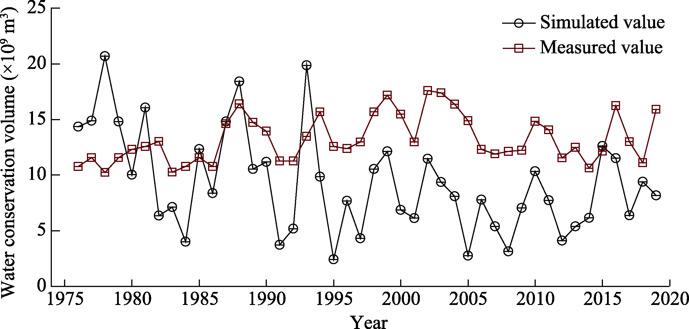
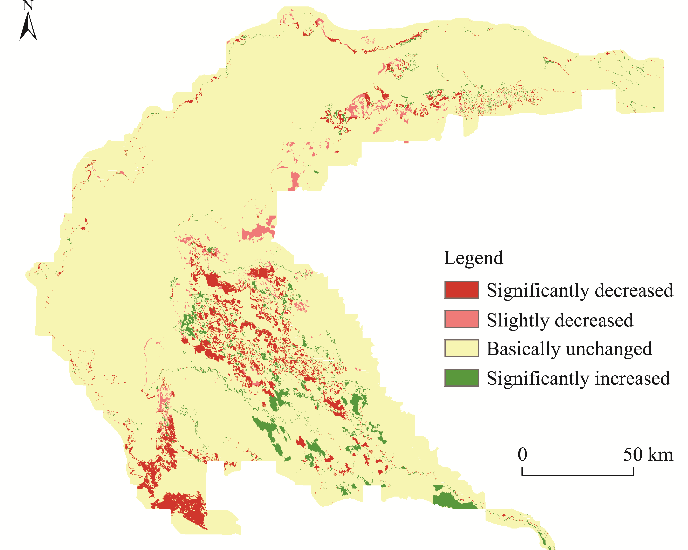
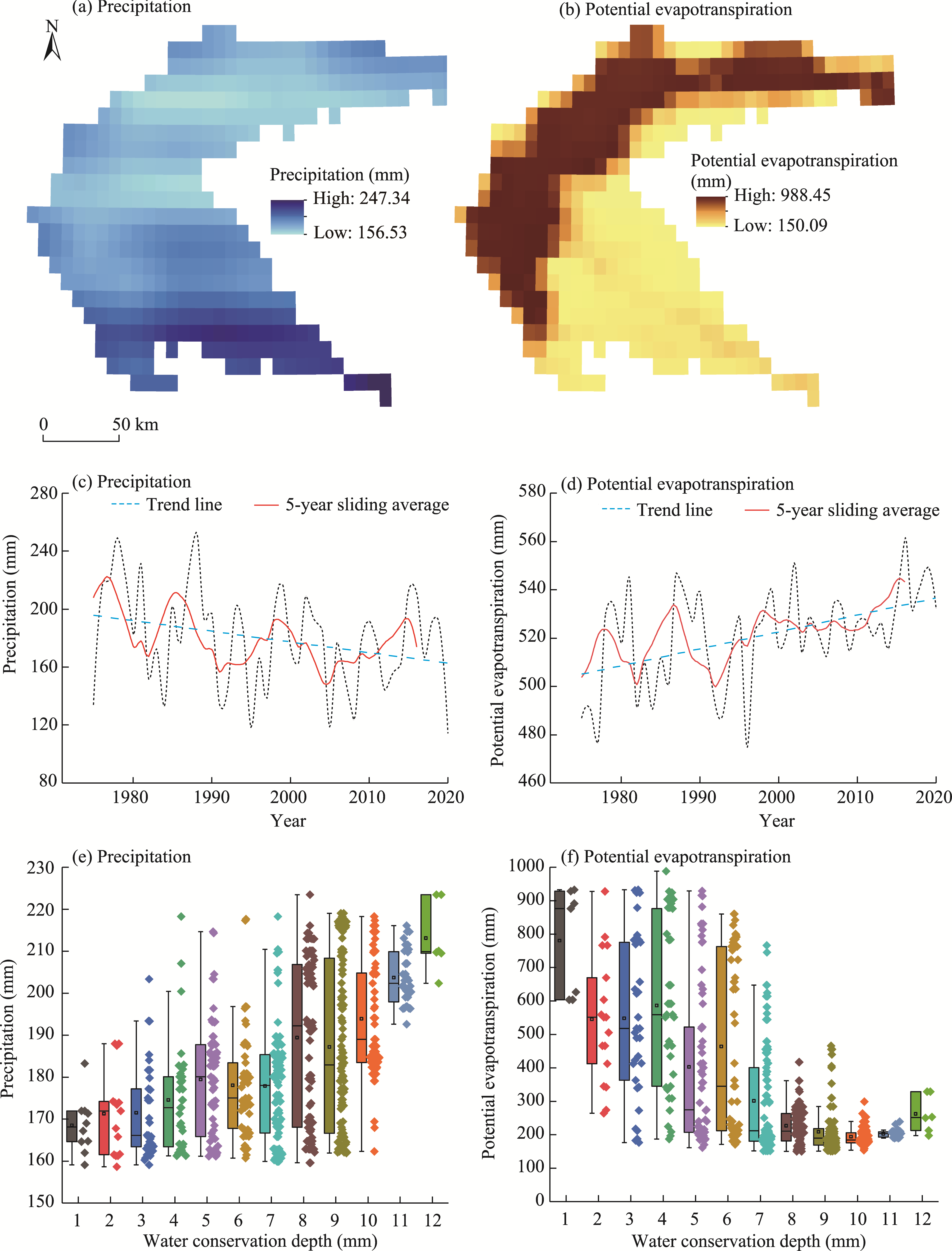
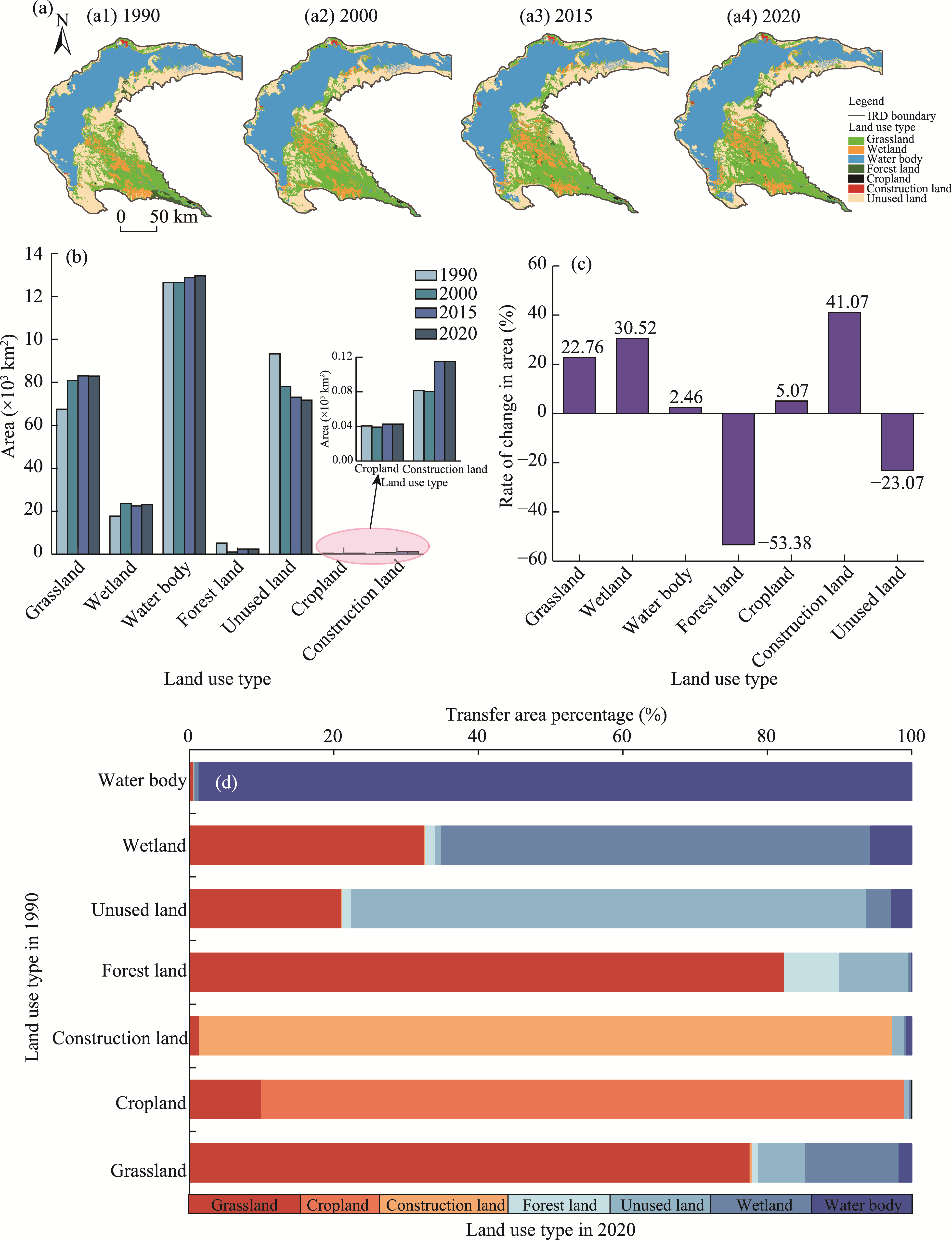
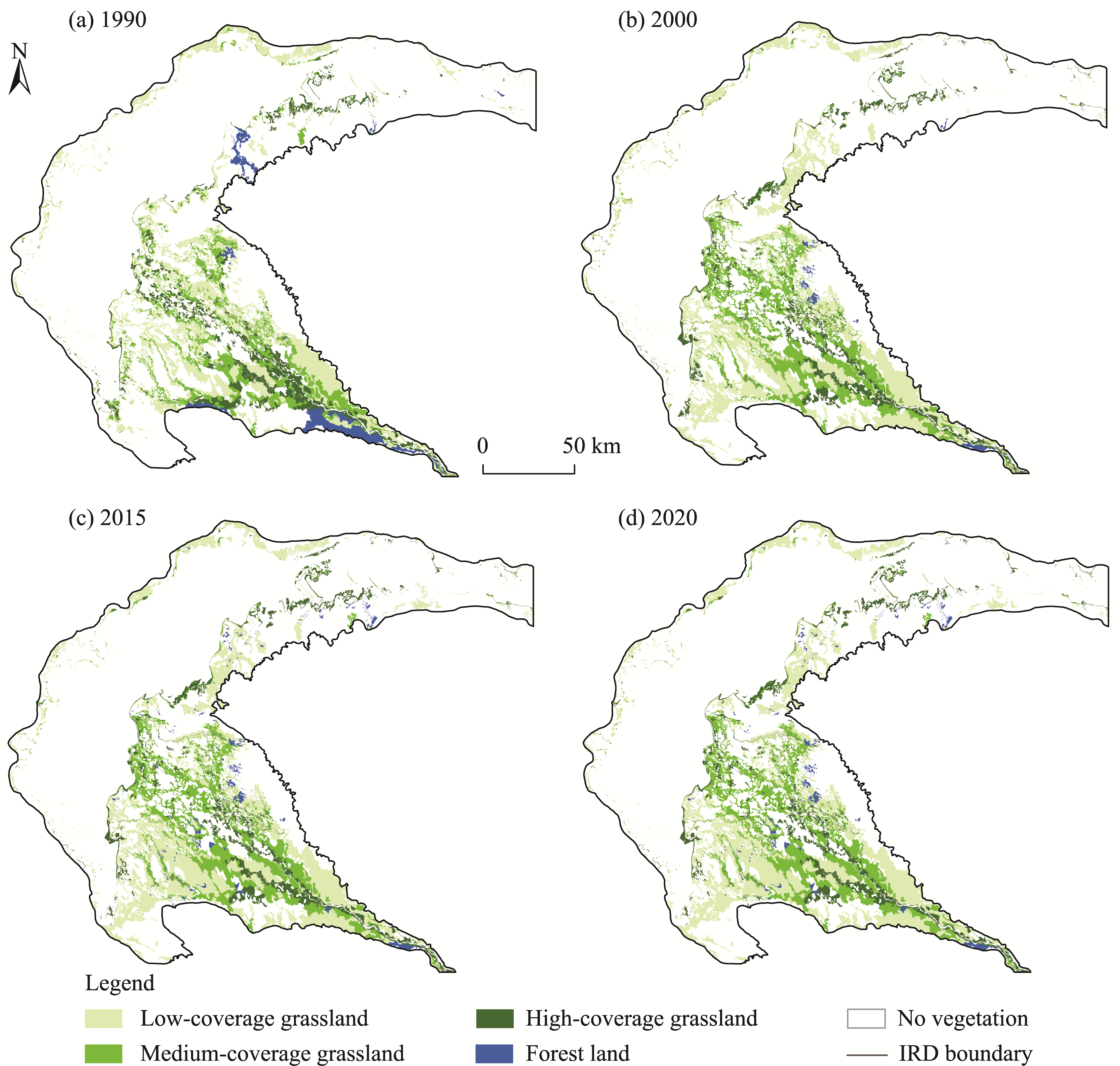
Abstract The Ili River Delta (IRD) is an ecological security barrier for the Lake Balkhash and an important water conservation area in Central Asia. In this study, we selected the IRD as a typical research area, and simulated the water yield and water conservation from 1975 to 2020 using the water yield module of the Integrated Valuation of Ecosystem Services and Tradeoffs (InVEST) model. We further analyzed the temporal and spatial variations in the water yield and water conservation in the IRD from 1975 to 2020, and investigated the main driving factors (precipitation, potential evapotranspiration, land use/land cover change, and inflow from the Ili River) of the water conservation variation based on the linear regression, piecewise linear regression, and Pearson's correlation coefficient analyses. The results indicated that from 1975 to 2020, the water yield and water conservation in the IRD showed a decreasing trend, and the spatial distribution pattern was "high in the east and low in the west"; overall, the water conservation of all land use types decreased slightly. The water conservation volume of grassland was the most reduced, although the area of grassland increased owing to the increased inflow from the Ili River. At the same time, the increased inflow has led to the expansion of wetland areas, the improvement of vegetation growth, and the increase of regional evapotranspiration, thus resulting in an overall reduction in the water conservation. The water conservation depth and precipitation had similar spatial distribution patterns; the change in climate factors was the main reason for the decline in the water conservation function in the delta. The reservoir in the upper reaches of the IRD regulated runoff into the Lake Balkhash, promoted vegetation restoration, and had a positive effect on the water conservation; however, this positive effect cannot offset the negative effect of enhanced evapotranspiration. These results provide a reference for the rational allocation of water resources and ecosystem protection in the IRD.
|
|
Received: 16 April 2023
Published: 31 December 2023
|
Corresponding Authors:
*MA Yonggang (E-mail: mayg@xju.edu.cn)
|
|
|
| [1] |
Bai Y, Chu D, Tian L, et al. 2014. Assessing the importance of water conservation function in Wuhan City Circle. Journal of Geo-information Science, 16(2): 233-241. (in Chinese)
|
|
|
| [2] |
Bao Y B, Li T, Liu H, et al. 2016. Spatial and temporal changes of water conservation of Loess Plateau in northern Shaanxi Province by InVEST model. Geographical Research, 35(4): 664-676. (in Chinese)
doi: 10.11821/dlyj201604006
|
|
|
| [3] |
Baral H, Keenan R J, Sharma S K, et al. 2014. Spatial assessment and mapping of biodiversity and conservation priorities in a heavily modified and fragmented production landscape in north-central Victoria, Australia. Ecological Indicators, 36: 552-562.
doi: 10.1016/j.ecolind.2013.09.022
|
|
|
| [4] |
Canadell J, Jackson R B, Ehleringer J B, et al. 1996. Maximum rooting depth of vegetation types at the global scale. Oecologia, 108(4): 583-595.
doi: 10.1007/BF00329030
pmid: 28307789
|
|
|
| [5] |
Cao Y J, Ma Y G, Liu T, et al. 2022. Analysis of spatial-temporal variations and driving factors of typical tail-reach wetlands in the Ili-Balkhash Basin, Central Asia. Remote Sensing, 14(16): 3986, doi: 10.3390/rs14163986.
|
|
|
| [6] |
Deng K M, Shi P L, Xie G D, 2002. Water conservation of forest ecosystem in the upper reaches of Yangtze River and its benefits. Resources Science, 24(6): 68-73. (in Chinese)
|
|
|
| [7] |
Deng M J, Wang Z J, Wang J Y, 2011. Analysis of Balkhash Lake ecological water level evolvement and its regulation strategy. Journal of Hydraulic Engineering, 42(4): 403-413.
|
|
|
| [8] |
Fan L Y, Cai T Y, Wen Q, et al. 2023. Scenario simulation of land use change and carbon storage response in Henan Province, China: 1990-2050. Ecological Indicators, 154: 110660, doi: 10.1016/j.ecolind.2023.110660.
|
|
|
| [9] |
Gao Y H, Wang H L, Zhou X, et al. 2016. Remote sensing monitoring and analyses of the dynamic change of Balkhash Lake in the last 30 years. Environment and Sustainable Development, 41(1): 102-106. (in Chinese)
|
|
|
| [10] |
Guo L D, Xia Z Q, Wang Z J, 2011. Comparisons of hydrological variations and environmental effects between Aral Sea and Lake Balkhash. Advances in Water Science, 22(6): 764-770. (in Chinese)
|
|
|
| [11] |
Guo L D, Xia Z Q. 2014. Temperature and precipitation long-term trends and variations in the Ili-Balkhash Basin. Theoretical and Applied Climatology, 115(1): 219-229.
doi: 10.1007/s00704-013-0883-3
|
|
|
| [12] |
Hong Y C, Bai L, Yu S L. 2018. Study on the change of water conservation function of Mu Chuan County. Technology Innovation and Application, (25): 91-92. (in Chinese)
|
|
|
| [13] |
Hu Y T, Zhang F, Luo Z Z, et al. 2023. Soil and water conservation effects of different types of vegetation cover on runoff and erosion driven by climate and underlying surface conditions. CATENA, 231: 107347, doi: 10.1016/j.catena.2023.107347.
|
|
|
| [14] |
Hu M, Sheng Y W. 2022. Study on variation characteristics of precipitation and water resources in Qingdao. Journal of China Hydrology, 42(1): 103-108, 28. (in Chinese)
|
|
|
| [15] |
Hu W M, Li G, Li Z N. 2021. Spatial and temporal evolution characteristics of the water conservation function and its driving factors in regional lake wetlands—Two types of homogeneous lakes as examples. Ecological Indicators, 130: 108069, doi: 10.1016/j.ecolind.2021.108069.
|
|
|
| [16] |
Jia G Y, Hu W M, Zhang B, et al. 2022. Assessing impacts of the ecological retreat project on water conservation in the Yellow River Basin. Science of the Total Environment, 828: 154483, doi: 10.1016/j.scitotenv.2022.154483.
|
|
|
| [17] |
Jin X. 2016. Study on the red line for water containment protection in typical semi-arid areas. MSc Thesis. Xi'an: Northwest University. (in Chinese)
|
|
|
| [18] |
Lee Rodgers J, Alan Nicewander W. 1988. Thirteen ways to look at the correlation coefficient. The American Statistician, 42(1): 59-66.
|
|
|
| [19] |
Li M Y, Liang D, Xia J, et al. 2021. Evaluation of water conservation function of Danjiang River Basin in Qinling Mountains, China based on InVEST model. Journal of Environmental Management, 286: 112212, doi: 10.1016/j.jenvman.2021.112212.
|
|
|
| [20] |
Li X, Cui X, He X F, et al. 2022a. Analyses of spatial and temporal characteristics of water conservation function in Qaidam Basin. Pratacultural Science, 39(4): 660-671. (in Chinese)
|
|
|
| [21] |
Li X, Zou C X, Chen Y M, et al. 2022b. Spatial-temporal pattern changes and driving factors of water conservation function in Beijing-Tianjin-Hebei region from 2000 to 2019. Bulletin of Soil and Water Conservation, 42(5): 265-274. (in Chinese)
|
|
|
| [22] |
Li Y Y, Ma X S, Qi G H, et al. 2022c. Studies on water retention function of Anhui Province based on InVEST model of parameter localization. Resources and Environment in the Yangtze Basin, 31(2): 313-325. (in Chinese)
|
|
|
| [23] |
Liu S. 2019. Wetland ecosystem services evaluation based on the InVEST model. MSc Thesis. Harbin: Harbin Normal University. (in Chinese)
|
|
|
| [24] |
Long A H, Deng M J, Xie L, et al. 2011. A study of the water balance of Lake Balkhash. Journal of Glaciology and Geocryology, 33(6): 1341-1352. (in Chinese)
|
|
|
| [25] |
Luo G P, Wang Y G, Zhu L, et al. 2012. Influence mechanism of landscape structure in River Ili Delta. Arid Land Geography, 35(6): 897-908. (in Chinese)
|
|
|
| [26] |
Marquès M, Bangash R F, Kumar V, et al. 2013. The impact of climate change on water provision under a low flow regime: A case study of the ecosystem services in the Francoli River basin. Journal of Hazardous Materials, 263: 224-232.
doi: 10.1016/j.jhazmat.2013.07.049
|
|
|
| [27] |
Nakayama Y, Tanaka S, Sugimura T, et al. 1997. Analysis of hydrological changes in lakes of Asian arid zone by satellite data. Earth Surface Remote Sensing, 3222: 201-210.
|
|
|
| [28] |
Nelson E, Mendoza G, Regetz J, et al. 2009. Modeling multiple ecosystem services, biodiversity conservation, commodity production, and tradeoffs at landscape scales. Frontiers in Ecology and the Environment, 7(1): 4-11.
doi: 10.1890/080023
|
|
|
| [29] |
Qiao X R, Li Z J, Lin J K, et al. 2023. Assessing current and future soil erosion under changing land use based on InVEST and FLUS models in the Yihe River Basin, North China. International Soil and Water Conservation Research, doi: 10.1016/j.iswcr.2023.07.001.
|
|
|
| [30] |
Sánchez-Canales M, López-Benito A, Passuello A, et al. 2012. Sensitivity analysis of ecosystem service valuation in a Mediterranean watershed. Science of the Total Environment, 440: 140-153.
doi: 10.1016/j.scitotenv.2012.07.071
|
|
|
| [31] |
Sharp R, Chaplin-Kramer R, Wood S, et al. 2018. InVEST User's Guide. The Natural Capital Project: Stanford University, University of Minnesota, the Nature Conservancy, and World Wildlife Fund. [2022-12-17]. https://www.researchgate.net/publication/323832082_InVEST_User's_Guide.
|
|
|
| [32] |
Su C H, Fu B J. 2013. Evolution of ecosystem services in the Chinese Loess Plateau under climatic and land use changes. Global and Planetary Change, 101: 119-128.
doi: 10.1016/j.gloplacha.2012.12.014
|
|
|
| [33] |
Tallis H, Polasky S. 2009. Mapping and valuing ecosystem services as an approach for conservation and natural-resource management. Annals of the New York Academy of Sciences, 1162: 265-283.
|
|
|
| [34] |
Wang H Y, Song J X, Wu Q. 2022a. Temporal and spatial variation characteristics of water conservation function of Qinling Mountains under the background of climate change. Journal of Soil and Water Conservation, 36(5): 212-219. (in Chinese)
|
|
|
| [35] |
Wang J F, Wu T L, Li Q, et al. 2021a. Quantifying the effect of environmental drivers on water conservation variation in the eastern Loess Plateau, China. Ecological Indicators, 125: 107493, doi: 10.1016/j.ecolind.2021.107493.
|
|
|
| [36] |
Wang J Y, Lu J Y. 2009. Hydrological and ecological impacts of water resources development in the Ili River Basin. Journal of Natural Resources, 24(7): 1297-1307. (in Chinese)
|
|
|
| [37] |
Wang N, Bi H X, Peng R D, et al. 2023. Disparities in soil and water conservation functions among different forest types and implications for afforestation on the Loess Plateau. Ecological Indicators, 155: 110935, doi: 10.1016/j.ecolind.2023.110935.
|
|
|
| [38] |
Wang X X, Shen H T, Li X Y, et al. 2013. Concepts, processes and quantification methods of the forest water conservation at the multiple scales. Acta Ecologica Sinica, 33(4): 1019-1030. (in Chinese)
doi: 10.5846/stxb
|
|
|
| [39] |
Wang Y F, Ye A Z, Peng D Z, et al. 2022b. Spatiotemporal variations in water conservation function of the Tibetan Plateau under climate change based on InVEST model. Journal of Hydrology: Regional Studies, 41: 101064, doi: 10.1016/j.ejrh.2022.101064.
|
|
|
| [40] |
Wang Z, Xue Z C, Wang L, et al. 2021b. Analysis of the spatio-temporal characteristics of the water retention function of the Wulie River Basin in Chengde City. Pratacultural Science, 38(6): 1047-1059. (in Chinese)
|
|
|
| [41] |
Wang Z, Huang Y, Liu T, et al. 2022c. Analysis of the water demand-supply gap and scarcity index in Lower Amu Darya River Basin, Central Asia. International Journal of Environmental Research and Public Health, 19(2): 743, doi: 10.3390/ijerph19020743.
|
|
|
| [42] |
Wen X, Théau J. 2020. Spatiotemporal analysis of water-related ecosystem services under ecological restoration scenarios: a case study in northern Shaanxi, China. Science of the Total Environment, 720: 137477, doi: 10.1016/j.scitotenv.2020.137477.
|
|
|
| [43] |
Wu D, Shao Q Q, Liu J Y, et al. 2016. Spatiotemporal dynamics of water regulation service of grassland ecosystem in China. Research of Soil and Water Conservation, 23(5): 256-260. (in Chinese)
|
|
|
| [44] |
Wu Q, Song J X, Sun H T, et al. 2023. Spatiotemporal variations of water conservation function based on EOF analysis at multi time scales under different ecosystems of Heihe River Basin. Journal of Environmental Management, 325: 116532, doi: 10.1016/j.jenvman.116532.
|
|
|
| [45] |
Xiao T T, Xia Z Q, Guo L D, et al. 2011. Temperature characteristics in the Balkhash Lake Basin from 1936 to 2005. Journal of Hohai University (Natural Sciences), 39(4): 391-396. (in Chinese)
|
|
|
| [46] |
Xie L, Long A H, Deng M J, et al. 2011. Study on ecological water consumption in delta of the lower reaches of Ili River. Journal of Glaciology and Geocryology, 33(6): 1330-1340. (in Chinese)
|
|
|
| [47] |
Xie Y C. 2015. Spatiotemporal change of ecosystem services based on InVEST Model in the Bailong River Watershed, Gansu. PhD Dissertation. Lanzhou: Lanzhou University. (in Chinese)
|
|
|
| [48] |
Xu F, Zhao L L, Jia Y W, et al. 2022. Evaluation of water conservation function of Beijiang River basin in Nanling Mountains, China, based on WEP-L model. Ecological Indicators, 134: 108383, doi: 10.1016/j.ecolind.2021.108383.
|
|
|
| [49] |
Xue J, Li Z S, Feng Q, et al. 2022a. Spatiotemporal variation characteristics of water conservation amount in the Qilian Mountains from 1980 to 2017. Journal of Glaciology and Geocryology, 44(1): 1-13. (in Chinese)
|
|
|
| [50] |
Xue J, Li Z X, Feng Q, et al. 2022b. Spatiotemporal variations of water conservation and its influencing factors in ecological barrier region, Qinghai-Tibet Plateau. Journal of Hydrology: Regional Studies, 42: 101164, doi: 10.1016/j.ejrh.2022.101164.
|
|
|
| [51] |
Yang C D. 1993. Changes in the water level of Lake Balkhash and its causes. Arid Land Geography, 16(1): 36-42. (in Chinese)
|
|
|
| [52] |
Yang D, Liu W, Tang L Y, et al. 2019. Estimation of water provision service for monsoon catchments of South China: Applicability of the InVEST model. Landscape and Urban Planning, 182: 133-143.
doi: 10.1016/j.landurbplan.2018.10.011
|
|
|
| [53] |
Yao J, Chen Q H, Li Q F, et al. 2022. Spatial and temporal variability of evapotranspiration and influencing factors in the Ili River-Balkhash Lake Basin. Arid Zone Research, 39(5): 1564-1575. (in Chinese)
|
|
|
| [54] |
Yin G D, Wang X, Zhang X, et al. 2020. InVEST Model based estimation of water yield in North China and its sensitivities to climate variables. Water, 12(6): 1692, doi: 10.3390/w12061692.
|
|
|
| [55] |
Yu X L, Wen J G, Yu J L, et al. 2010. Image correction algorithm of water quality remote sensing based on piecewise linear regression. Remote Sensing Information, 32(6): 39-43.
|
|
|
| [56] |
Zhang X N, Li X D, Ning L L, et al. 2022. A bibliometric evaluation of the status of the water conservation function of grassland ecosystems. Acta Prataculturae Sinica, 31(6): 35-49. (in Chinese)
|
|
|
| [57] |
Zheng Q H, Luo G P, Zhu L, et al. 2010. Prediction of landscape patterns in Ili River Delta based on CA_Markov model. Chinese Journal of Applied Ecology, 21(4): 873-882. (in Chinese)
|
|
|
| [58] |
Zhou W J, Xia Z Q, Huang F, et al. 2013. Variation characteristics of precipitation and its annual distribution in Balkhash Lake Basin. Water Resources and Power, 31(6): 10-13. (in Chinese)
|
|
|
|
Viewed |
|
|
|
Full text
|
|
|
|
|
Abstract
|
|
|
|
|
Cited |
|
|
|
|
| |
Shared |
|
|
|
|
| |
Discussed |
|
|
|
|