| Research article |
|


|
|
|
| Optimizing land-use structure in the Jinghe River Basin under the goal of efficient water resource utilization |
ZHENG Dan, PEI Tingting*( ), CHENG Hong, CHEN Ying, XIE Baopeng |
| College of Management, Gansu Agricultural University, Lanzhou 730070, China |
|
|
|
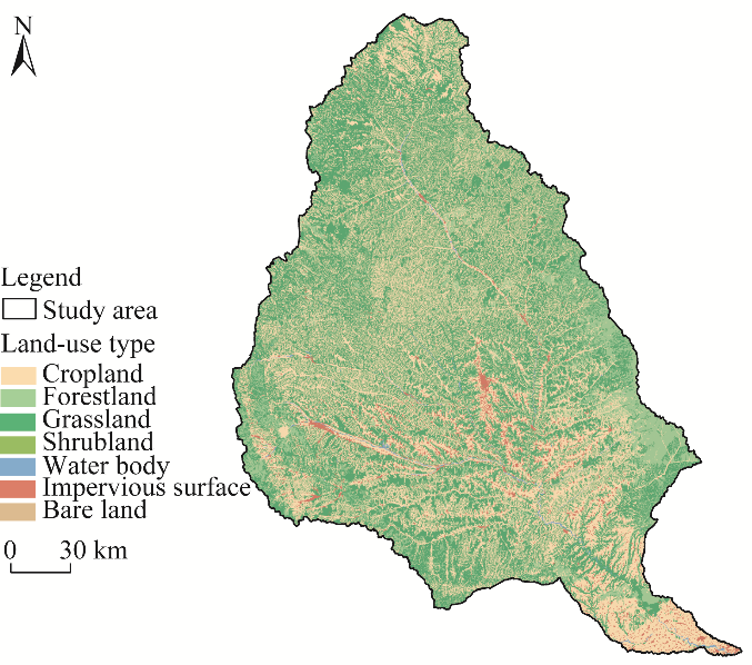
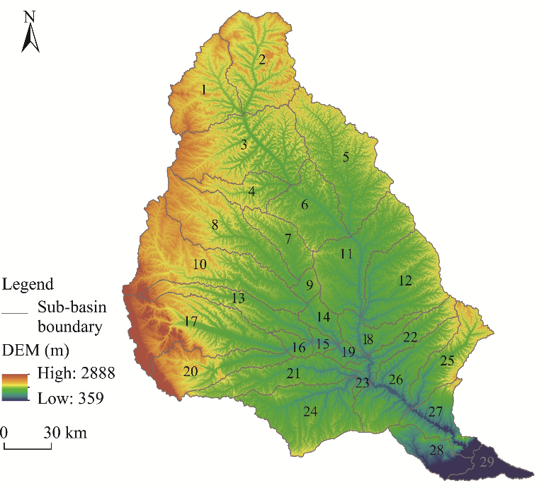
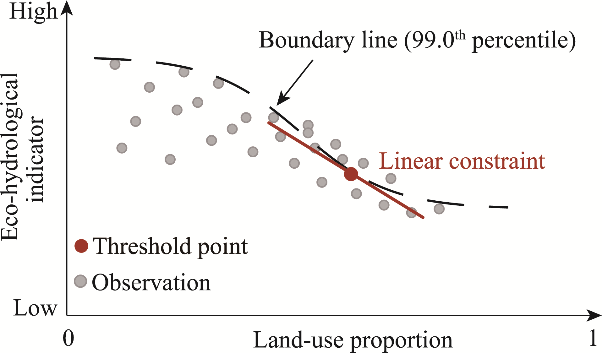
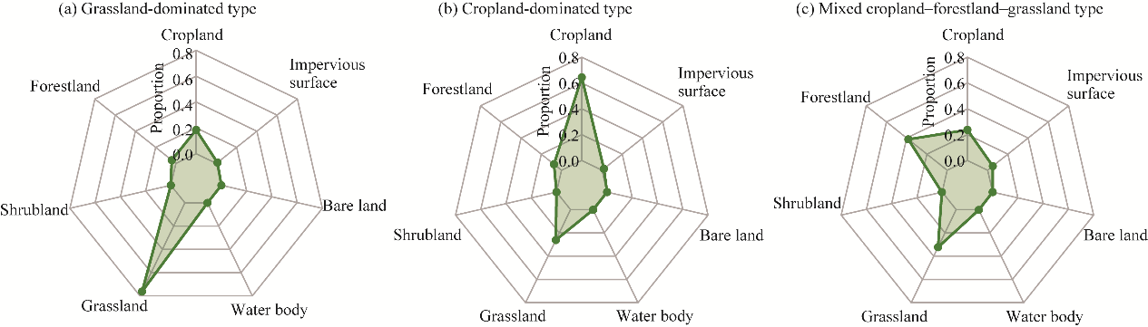
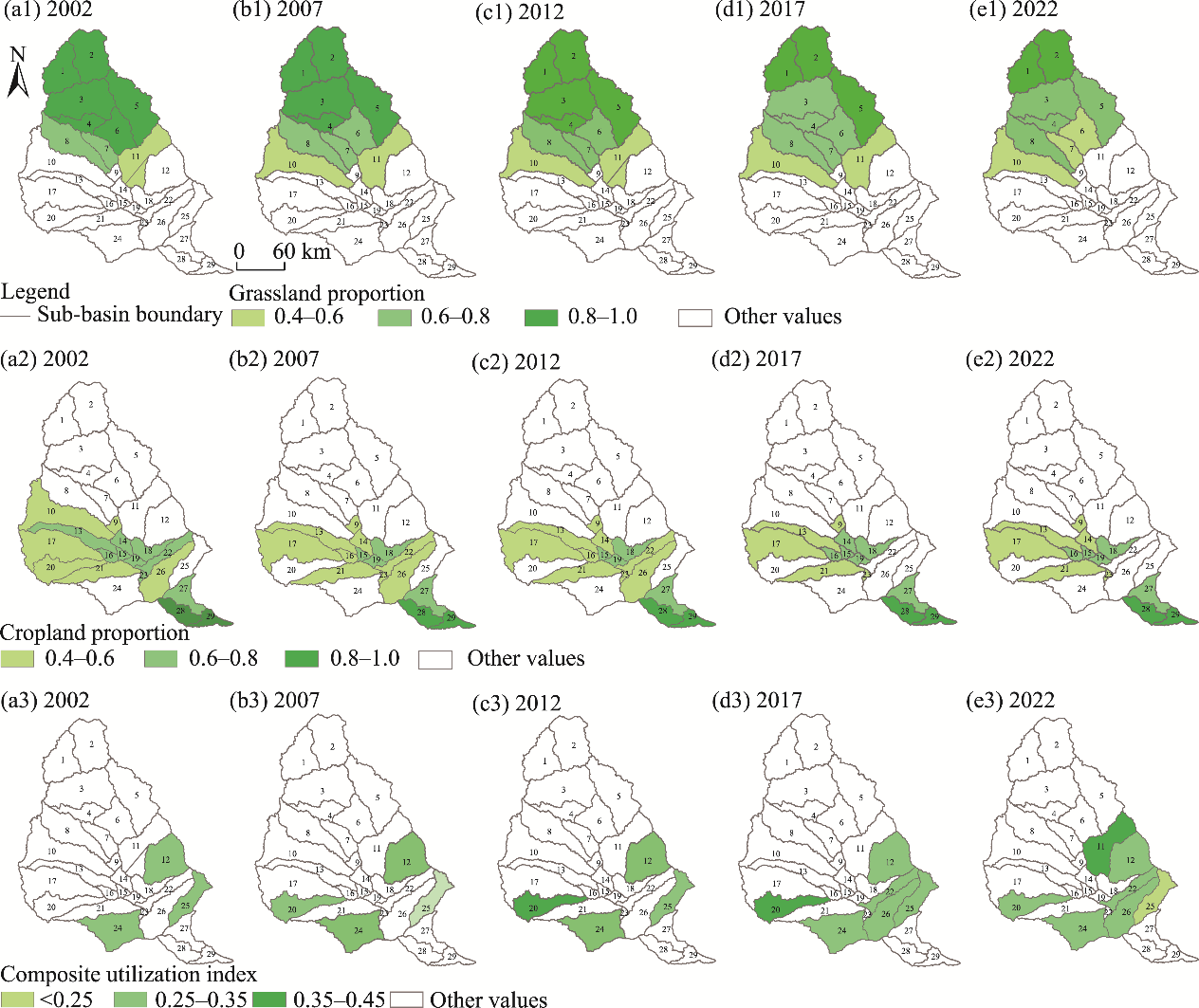
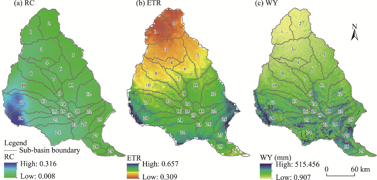
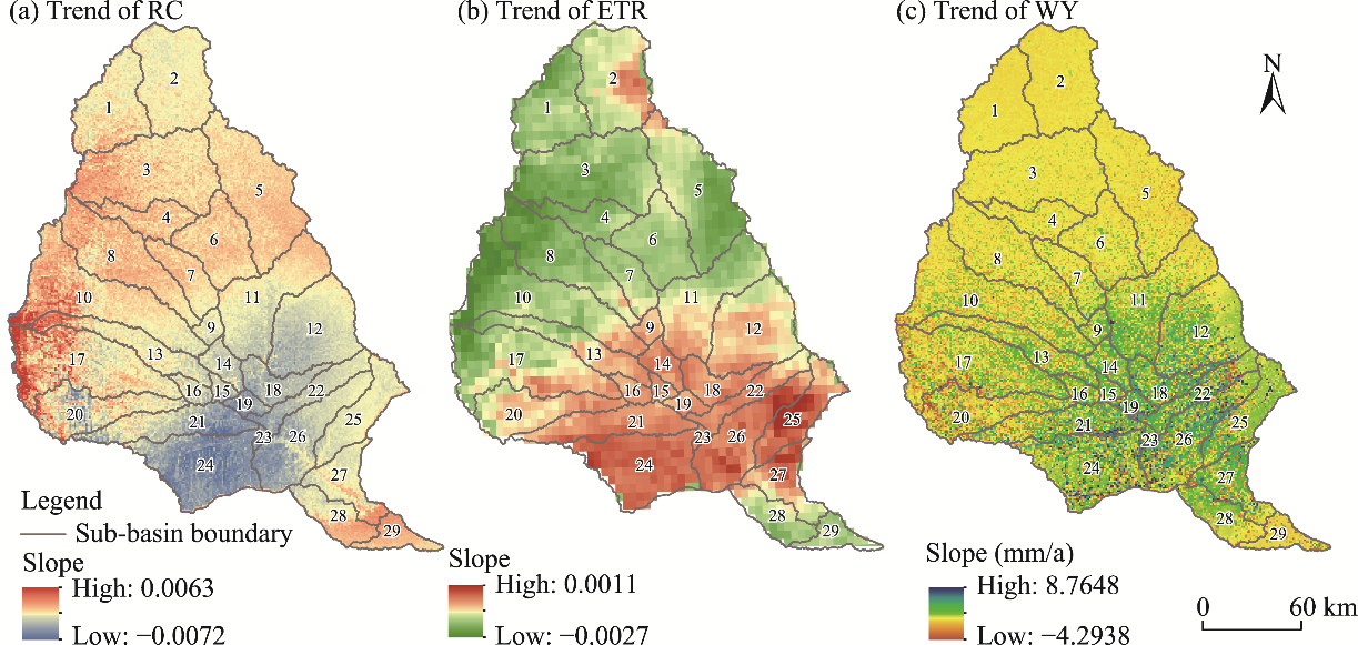
Abstract The efficient use of limited water resources remains a critical challenge in arid and semi-arid areas, where land-use structure exerts strong control over eco-hydrological processes. The Jinghe River Basin, located in the central Loess Plateau of China, is a typical semi-arid watershed that has undergone pronounced land-use transitions under the Grain-for-Green Program. This study developed a sub-basin- scale analytical framework to optimize the land-use structure in the Jinghe River Basin to improve water-use efficiency. Multi-source remote sensing data (2002-2022) were used to classify the dominant land-use structures based on K-means clustering, and to quantify the key hydrological indicators, including the runoff coefficient, evapotranspiration ratio, and water yield. The eco-hydrological thresholds and trade-off-synergy relationships were identified through boundary-line and correlation analyses, and were then incorporated into the land-use optimization model that was solved using LINGO and spatially simulated in R v.4.2.2 software. The results showed that the basin can be classified into grassland-dominated, cropland- dominated, and mixed cropland-forestland-grassland sub-basins with distinct hydrological responses. Moreover, the optimization results based on these boundary-line thresholds indicated structure-specific optimal land-use proportions for water-use efficiency: the grassland proportion was approximately 0.85 in grassland-dominated sub-basins, and the cropland proportion was approximately 0.63 in cropland-dominated sub-basins. In mixed cropland-forestland-grassland sub-basins, the optimal cropland and grassland proportions were approximately 0.33 and 0.41, respectively, with a composite utilization index of 0.35. These thresholds represented the balance points among the runoff regulation, evapotranspiration control, and water-yielding capacity under limited water resources in the region. By explicitly linking the land-use configuration with the hydrological efficiency through threshold-based constraints, this study provides a data-efficient operational framework for coordinated land-water management in the Loess Plateau, as well as other semi-arid river basins.
|
|
Received: 13 November 2025
Published: 30 November 2026
|
|
Corresponding Authors:
*PEI Tingting (E-mail: peitt@gsau.edu.cn)
|
| About author: Author contributions
Conceptualization: PEI Tingting; Data curation: ZHENG Dan, CHENG Hong, CHEN Ying, XIE Baopeng; Formal analysis: ZHENG Dan, CHENG Hong; Funding acquisition: PEI Tingting; Investigation: CHENG Hong; Methodology: ZHENG Dan, PEI Tingting; Project administration: PEI Tingting, CHEN Ying; Resources: PEI Tingting; Software: ZHENG Dan; Supervision: ZHENG Dan, CHENG Hong; Validation: ZHENG Dan, Visualization: ZHENG Dan, CHENG Hong, CHEN Ying, XIE Baopeng; Writing - original draft preparation: ZHENG Dan; Writing - review and editing: ZHENG Dan, PEI Tingting, CHEN Ying, XIE Baopeng. All authors approved the manuscript.
|
|
|
| [1] |
Anderson M C, Hain C, Wardlow B, et al. 2011. Evaluation of drought indices based on thermal remote sensing of evapotranspiration over the continental United States. Journal of Climate, 24(8): 2025-2044.
|
|
|
| [2] |
Banjara M, Bhusal A, Ghimire A B, et al. 2024. Impact of land use and land cover change on hydrological processes in urban watersheds: analysis and forecasting for flood risk management. Geosciences, 14(2): 40, doi: 10.3390/geosciences14020040.
|
|
|
| [3] |
Chawanda C J, Nkwasa A, Thiery W, et al. 2024. Combined impacts of climate and land-use change on future water resources in Africa. Hydrology and Earth System Sciences, 28(1): 117-138.
|
|
|
| [4] |
Chen N, Wang R. 2024. Spatial differences in the response of runoff to climate and land use changes in the Yiluo River Basin. Journal of Resources and Ecology, 15(5): 1299-1310.
|
|
|
| [5] |
Chong Y H, Zeng Q M. 2024. Long-term ground deformation monitoring and quantitative interpretation in Shanghai using multi-platform TS-InSAR, PCA, and K-means clustering. Remote Sensing, 16(22): 4188, doi: 10.3390/rs16224188.
|
|
|
| [6] |
Conrad A C, März M, Chakrabarti R. 2019. Adapted subsurface water solutions across continents. Journal of Water Security, 5: jws2019006, doi: 10.15544/jws.2019.006.
|
|
|
| [7] |
Das P C, Esraz-Ul-Zannat M. 2022. Assessing the impacts of land use-land cover changes on direct surface runoff: a remote sensing approach in Khulna City. Water Science and Technology, 85(10): 3122-3144.
|
|
|
| [8] |
de Fleury M, Kergoat L, Grippa M. 2023. Hydrological regime of Sahelian small waterbodies from combined Sentinel-2 MSI and Sentinel-3 Synthetic Aperture Radar Altimeter data. Hydrology and Earth System Sciences, 27(11): 2189-2204.
|
|
|
| [9] |
Deng L Z, Fei K, Sun T Y, et al. 2019. Characteristics of runoff processes and nitrogen loss via surface flow and interflow from weathered granite slopes of Southeast China. Journal of Mountain Science, 16(5): 1048-1064.
|
|
|
| [10] |
Dey P, Mishra A. 2017. Separating the impacts of climate change and human activities on streamflow: A review of methodologies and critical assumptions. Journal of Hydrology, 548: 278-290.
|
|
|
| [11] |
Ding Y, Feng H H, Zou B. 2022. Remote sensing-based estimation on hydrological response to land use and cover change. Forests, 13(11): 1749, doi: 10.3390/f13111749.
|
|
|
| [12] |
Dong K N, Wang H W, Luo K, et al. 2024. The use of an optimized grey multi-objective programming-PLUS model for multi-scenario simulation of land use in the Weigan-Kuche River Oasis, China. Land, 13(6): 802, doi: 10.3390/land13060802.
|
|
|
| [13] |
Gomes E, Inácio M, Bogdzevič K, et al. 2021. Future land-use changes and its impacts on terrestrial ecosystem services: a review. Science of The Total Environment, 781: 146716, doi: 10.1016/j.scitotenv.2021.146716.
|
|
|
| [14] |
Gu H L, Liu S X, Huan C Y, et al. 2025. Multi-objective land use optimization based on NSGA-II and PLUS models: balancing economic development and carbon neutrality goals. Land, 14(8): 1585, doi: 10.3390/land14081585.
|
|
|
| [15] |
Gu X H, Zhang Q, Li J F, et al. 2019. Impact of urbanization on nonstationarity of annual and seasonal precipitation extremes in China. Journal of Hydrology, 575: 638-655.
|
|
|
| [16] |
Guan R H, Huang W, Li Y, et al. 2023. Can land use/land cover optimization improve the environmental flow guarantee in regulated basins? Journal of Hydrology, 626: 130309, doi: 10.1016/j.jhydrol.2023.130309.
|
|
|
| [17] |
Guo S C, Tian L, Chen S Y, et al. 2024. Analysis of effects of vegetation cover and elevation on water yield in an alpine basin of the Qilian Mountains in Northwest China by integrating the WRF-Hydro and Budyko framework. Journal of Hydrology, 629: 130580, doi: 10.1016/j.jhydrol.2023.130580.
|
|
|
| [18] |
Gyamfi C, Ndambuki J M, Salim R W. 2016. Hydrological responses to land use/cover changes in the Olifants Basin, South Africa. Water, 8(12): 588, doi: 10.3390/w8120588.
|
|
|
| [19] |
Hao R F, Yu D Y, Wu J G, et al. 2016. Constraint line methods and the applications in ecology. Chinese Journal of Plant Ecology, 40(10): 1100-1109. (in Chinese)
|
|
|
| [20] |
Hu J Y, Wu Y P, Wang L J, et al. 2021. Impacts of land-use conversions on the water cycle in a typical watershed in the southern Chinese Loess Plateau. Journal of Hydrology, 593: 125741, doi: 10.1016/j.jhydrol.2020.125741.
|
|
|
| [21] |
Hwang H T, Park Y J, Berg S J, et al. 2025. A dynamic meshing scheme for integrated hydrologic modeling to represent evolving landscapes. Science of The Total Environment, 976: 179129, doi: 10.1016/j.scitotenv.2025.179129.
|
|
|
| [22] |
IPCC (Intergovernmental Panel on Climate Change). 2022. Climate Change 2022:Impacts, Adaptation and Vulnerability. Contribution of Working Group II to the Sixth Assessment Report of the Intergovernmental Panel on Climate Change. Cambridge and New York: Cambridge University Press.
|
|
|
| [23] |
Kang W D, Ni F Q, Deng Y, et al. 2023. Response of blue and green water to climate and land use changes: a study in the Wujiang River Basin, China. Transactions of the Chinese Society of Agricultural Engineering, 39(19): 131-140. (in Chinese)
|
|
|
| [24] |
Li G, Zhang F M, Jing Y S, et al. 2017. Response of evapotranspiration to changes in land use and land cover and climate in China during 2001-2013. Science of The Total Environment, 596-597: 256-265.
|
|
|
| [25] |
Li Z J, Huang B S, Qiu J, et al. 2021. Analysis on evolution characteristics of ecological flow of Hanjiang River under changing environment. Water Resources Protection, 37(5): 22-29. (in Chinese)
|
|
|
| [26] |
Liaqat M U, Mohamed M M, Chowdhury R, et al. 2021. Impact of land use/land cover changes on groundwater resources in Al Ain region of the United Arab Emirates using remote sensing and GIS techniques. Groundwater for Sustainable Development, 14: 100587, doi: 10.1016/j.gsd.2021.100587.
|
|
|
| [27] |
Lin R L, Zhuo W S, Gao Y K, et al. 2020. Assessment of ecohydrological regulation service in the Beijiang River Basin based on SWAT model. Water Resources Protection, 36(6): 131-136. (in Chinese)
|
|
|
| [28] |
Liu H F, Yan H C, Guan M F. 2025. Evaluating the effects of topography and land use change on hydrological signatures: a comparative study of two adjacent watersheds. Hydrology and Earth System Sciences, 29(8): 2109-2132.
|
|
|
| [29] |
Lü Y H, Zhang L W, Feng X M, et al. 2015. Recent ecological transitions in China: greening, browning and influential factors. Scientific Reports, 5: 8732, doi: 10.1038/srep08732.
|
|
|
| [30] |
Luan C X, Liu R Z. 2025. Integrated ecological and environmental spatial soft constraint mechanism: urban multi-objective land use optimization under multiple scenarios. Journal of Environmental Management, 385: 125661, doi: 10.1016/j.jenvman.2025.125661.
|
|
|
| [31] |
Luo Q, Zhang J, Bao Y J, et al. 2025. Multi-scenario simulation of land use optimization based on ecosystem services and ecological security patterns in the Liaohe River Basin. Frontiers in Environmental Science, 13: 1647039, doi: 10.3389/fenvs.2025.1647039.
|
|
|
| [32] |
Lyu J Q, Yang Y H, Yin S S, et al. 2024. Effects of environmental changes on flood patterns in the Jing River Basin: a case study from the Loess Plateau, China. Land, 13(12): 2053, doi: 10.3390/land13122053.
|
|
|
| [33] |
Maxwell C O, Oonge Z I, Odira P M A, et al. 2024. Water-energy nexus-based optimization of the water supply infrastructure in a dryland urban setting. Water, 16(21): 3073, doi: 10.3390/w16213073.
|
|
|
| [34] |
Omer A, Ma Z G, Zheng Z Y, et al. 2020. Natural and anthropogenic influences on the recent droughts in Yellow River Basin, China. Science of The Total Environment, 704: 135428, doi: 10.1016/j.scitotenv.2019.135428.
|
|
|
| [35] |
Otamendi U, Maiza M, Olaizola I G, et al. 2024. Integrated water resource management in the Segura Hydrographic Basin: an artificial intelligence approach. Journal of Environmental Management, 370: 122526, doi: 10.1016/j.jenvman.2024.122526.
|
|
|
| [36] |
Pearson K. 1895. VII. Note on regression and inheritance in the case of two parents. Proceedings of the Royal Society of London, 58(347-352): 240-242.
|
|
|
| [37] |
Shi X L, Yang Z Y, Yan D H, et al. 2014. On hydrological response to land-use/cover change in Luanhe River Basin. Advances in Water Science, 25(1): 21-27. (in Chinese)
|
|
|
| [38] |
Shiferaw N, Habte L, Waleed M. 2025. Land use dynamics and their impact on hydrology and water quality of a river catchment: A comprehensive analysis and future scenario. Environmental Science and Pollution Research, 32(7): 4124-4136.
|
|
|
| [39] |
Tajbakhsh S M, Memarian H, Kheyrkhah A. 2018. A GIS-based integrative approach for land use optimization in a semi-arid watershed. Global Journal of Environmental Science and Management, 4(1): 31-46.
|
|
|
| [40] |
Tang H, Halike A, Yao K X, et al. 2024. Ecosystem service valuation and multi-scenario simulation in the Ebinur Lake Basin using a coupled GMOP-PLUS model. Scientific Reports, 14: 5071, doi: 10.1038/s41598-024-55763-6.
|
|
|
| [41] |
Tang J, Song P H, Hu X J, et al. 2023. Coupled effects of land use and climate change on water supply in SSP-RCP scenarios: A case study of the Ganjiang River Basin, China. Ecological Indicators, 154: 110745, doi: 10.1016/j.ecolind.2023.110745.
|
|
|
| [42] |
Tang Z X, Zhou Z X, Wang D, et al. 2022. Impact of vegetation restoration on ecosystem services in the Loess Plateau, a case study in the Jinghe Watershed, China. Ecological Indicators, 142: 109183, doi: 10.1016/j.ecolind.2022.109183.
|
|
|
| [43] |
Teklay A, Dile Y T, Setegn S G, et al. 2019. Evaluation of static and dynamic land use data for watershed hydrologic process simulation: A case study in Gummara watershed, Ethiopia. CATENA, 172: 65-75.
|
|
|
| [44] |
Tezel A Ç, Akpınar A, Bor A, et al. 2025. Exploring hydrological response to land use/land cover change using the SWAT+ model in the İznik Lake Watershed, Türkiye. Water, 17(13): 1924, doi: 10.3390/w17131924.
|
|
|
| [45] |
Tong Y P, Wang Y Q, Zhou J X, et al. 2024. Dataset of soil hydraulic parameters in the Yellow River Basin based on in situ deep sampling. Scientific Data, 11: 740, doi: 10.1038/s41597-024-03576-7.
|
|
|
| [46] |
Toosi A S, Batelaan O, Shanafield M, et al. 2025. Land use‐land cover and hydrological modeling: A review. Wiley Interdisciplinary Reviews: Water, 12(2): e70013, doi: 10.1002/wat2.70013.
|
|
|
| [47] |
Verburg P H, Tabeau A, Hatna E. 2013. Assessing spatial uncertainties of land allocation using a scenario approach and sensitivity analysis: a study for land use in Europe. Journal of Environmental Management, 127: 132-144.
|
|
|
| [48] |
Wan Z G, Ding W G, Pu X T, et al. 2023. Analysis of the spatial-temporal variation and driving factors of water yield in Qilian Mountain National Park. Journal of Soil and Water Conservation, 37(6): 161-169. (in Chinese)
|
|
|
| [49] |
Wang B Y, Oguchi T, Zhang L. 2019a. Simulating impact of over-grazing on grassland degradation using GIS: a case study in the Heihe River Basin, China. Abstracts of the International Cartographic Association, 1: 15-20.
|
|
|
| [50] |
Wang S, Zhang Q, Yang T, et al. 2019b. River health assessment: Proposing a comprehensive model based on physical habitat, chemical condition and biotic structure. Ecological Indicators, 103: 446-460.
|
|
|
| [51] |
Wang Z, Zhong A Y, Li Q Z. 2024. Optimization of land use structure based on the coupling of GMOP and PLUS models: A case study of Lvliang City, China. Land, 13(8): 1335, doi: 10.3390/land13081335.
|
|
|
| [52] |
Wei X N, Long A H, Yin Z L, et al. 2022. Simulation of response of glacier runoff to climate change in the Hotan River Basin. Water Resources Protection, 38(4): 137-144. (in Chinese)
|
|
|
| [53] |
Worku T, Khare D, Tripathi S K. 2017. Modeling runoff-sediment response to land use/land cover changes using integrated GIS and SWAT model in the Beressa watershed. Environmental Earth Sciences, 76: 550, doi: 10.1007/s12665-017-6883-3.
|
|
|
| [54] |
Xin S J, Li Z G, Chen N, et al. 2024. The contribution of multi-objective land use optimization to reducing ecological risk: A case study of the Lanzhou-Xining urban agglomeration. Ecological Indicators, 168: 112604, doi: 10.1016/j.ecolind.2024.112604.
|
|
|
| [55] |
Xu C, Jiang Y N, Su Z H, et al. 2022. Assessing the impacts of Grain-for-Green Programme on ecosystem services in Jinghe River basin, China. Ecological Indicators, 137: 108757, doi: 10.1016/j.ecolind.2022.108757.
|
|
|
| [56] |
Yan F P, Shangguan W, Zhang J, et al. 2020. Depth-to-bedrock map of China at a spatial resolution of 100 meters. Scientific Data, 7: 2, doi: 10.1038/s41597-019-0345-6.
|
|
|
| [57] |
Yan R, Zhang X P, Yan S J, et al. 2018. Spatial patterns of hydrological responses to land use/cover change in a catchment on the Loess Plateau, China. Ecological Indicators, 92: 151-160.
|
|
|
| [58] |
Ye Z G, Yin S, Cao Y, et al. 2024. AI-driven optimization of agricultural water management for enhanced sustainability. Scientific Reports, 14: 25721, doi: 10.1038/s41598-024-76915-8.
|
|
|
| [59] |
Yellow River Conservancy Commission of the Ministry of Water Resources. 2020. Hydrological Yearbook of the Yellow River Basin (2006-2020). (in Chinese).
|
|
|
| [60] |
Yuan Z, Xu J J, Wang Y Q. 2019. Historical and future changes of blue water and green water resources in the Yangtze River source region, China. Theoretical and Applied Climatology, 138(1-2): 1035-1047.
|
|
|
| [61] |
Zang C F. 2017. Spatial and temporal variability of blue/green water flows in typical meteorological years in an inland river basin in China. Journal of Water and Climate Change, 8(1): 165-176.
|
|
|
| [62] |
Zhang H H, Zeng Y N, Jin X B, et al. 2016. Simulating multi-objective land use optimization allocation using Multi-agent system-A case study in Changsha, China. Ecological Modelling, 320: 334-347.
|
|
|
| [63] |
Zhang P P, Zhang L X, Hao Y, et al. 2024. Food-energy-water nexus optimization brings substantial reduction of urban resource consumption and greenhouse gas emissions. PNAS Nexus, 3(2): pgae028, doi: 10.1093/pnasnexus/pgae028.
|
|
|
| [64] |
Zhang S L, Wu G, Zhang H J, et al. 2021. Variation characteristics of runoff coefficients of Jinghe River Basin during 1966-2005. Water Resources and Power, 39(5): 33-36. (in Chinese)
|
|
|
| [65] |
Zhang X, Duan Y W, Duan J P, et al. 2022. A daily drought index based on evapotranspiration and its application in regional drought analyses. Science China Earth Sciences, 65(2): 317-336.
|
|
|
| [66] |
Zhang Y S, Habudula H. 2009. Study on land resource optimal allocation method based on LINGO 11.0. Environmental Science and Management, 34(4): 157-159. (in Chinese)
|
|
|
| [67] |
Zhao A Z, Zhu X F, Liu X F, et al. 2016. Impacts of land use change and climate variability on green and blue water resources in the Weihe River Basin of northwest China. CATENA, 137: 318-327.
|
|
|
| [68] |
Zhao X E, Fang K Y, Chen F, et al. 2023. Reconstructed Jing River streamflow from western China: A 399-year perspective for hydrological changes in the Loess Plateau. Journal of Hydrology, 621: 129573, doi: 10.1016/j.jhydrol.2023.129573.
|
|
|
| [69] |
Zheng Y W, Wang Z F, Li S J, et al. 2025. Analysis of spatiotemporal dynamic evolution characteristics and driving forces of land use/cover change in the Weihe River Basin in the past 30 years. Environmental Science, 46(11): 7106-7118. (in Chinese)
|
|
|
| [70] |
Zhou M, Cai Y L, Guan X L, et al. 2015. A hybrid inexact optimization model for land-use allocation of China. Chinese Geographical Science, 25(1): 62-73.
|
|
|
| [71] |
Zhou W Z. 2003. A study on available water capacity of main soil types in China based on GIS. MSc Thesis. Nanjing: Nanjing Agricultural University. (in Chinese)
|
|
|
|
Viewed |
|
|
|
Full text
|
|
|
|
|
Abstract
|
|
|
|
|
Cited |
|
|
|
|
| |
Shared |
|
|
|
|
| |
Discussed |
|
|
|
|