| Research article |
|


|
|
|
| Stable oxygen-hydrogen isotopes reveal water use strategies of Tamarix taklamakanensis in the Taklimakan Desert, China |
DONG Zhengwu1,2,3,4, LI Shengyu1,*( ), ZHAO Ying5, LEI Jiaqiang1, WANG Yongdong1, LI Congjuan1 ), ZHAO Ying5, LEI Jiaqiang1, WANG Yongdong1, LI Congjuan1 |
1 Xinjiang Institute of Ecology and Geography, Chinese Academy of Sciences, Urumqi 830011, China
2 College of Resources and Environment Science, Xinjiang University, Urumqi 830046, China
3 College of Life Science, Xinjiang Normal University, Urumqi 830054, China
4 University of Chinese Academy of Sciences, Beijing 100049, China
5 College of Resources and Environmental Engineering, Ludong University, Yantai 264025, China |
|
|
|
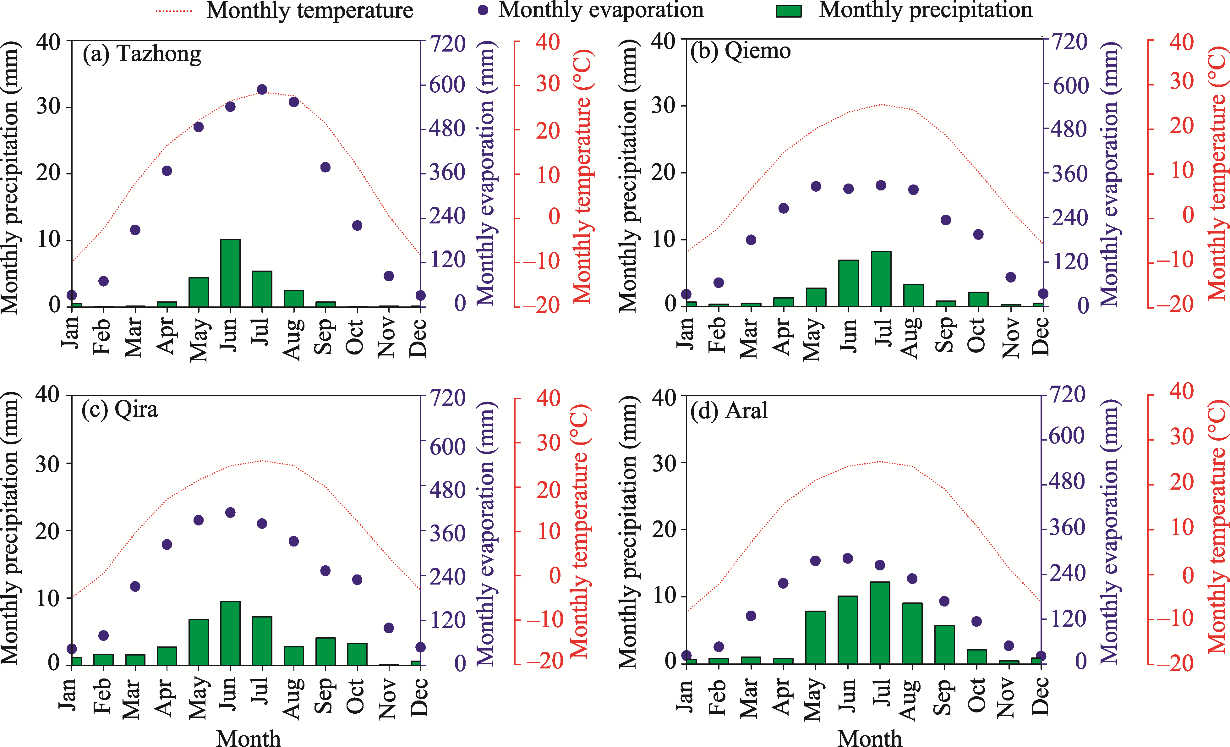
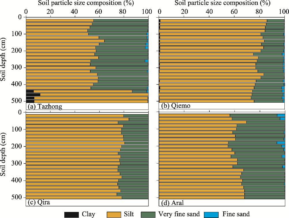
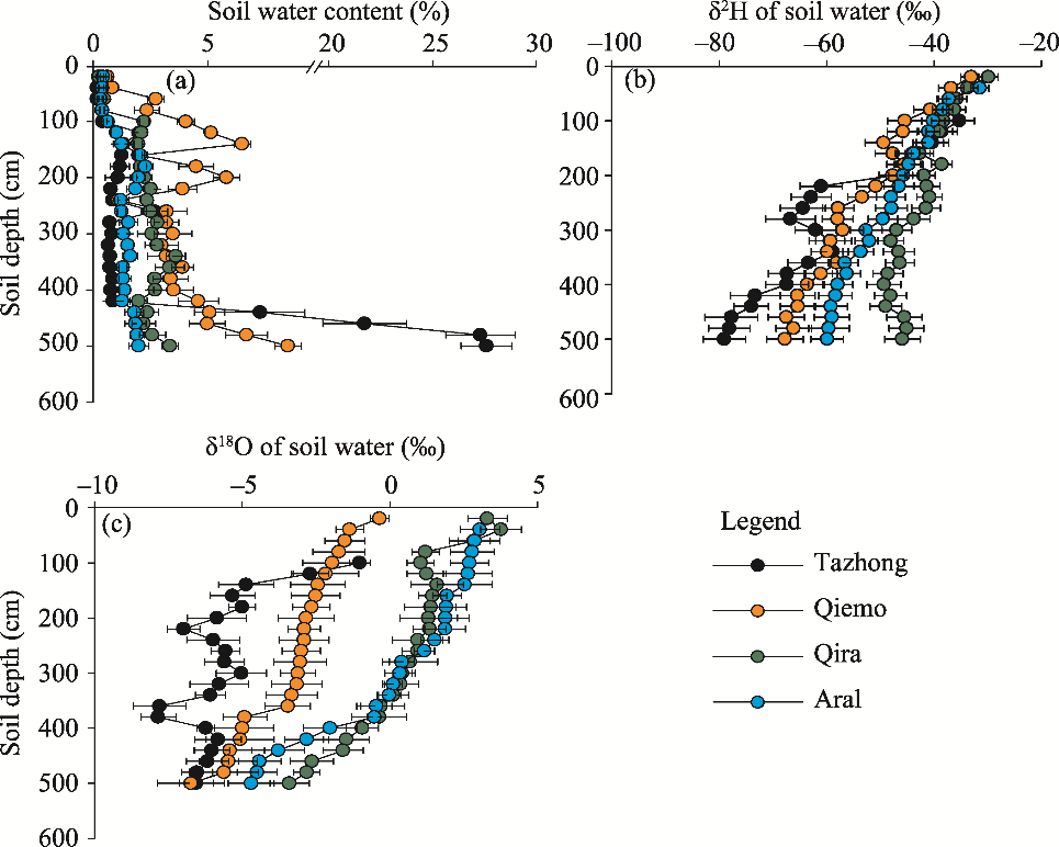
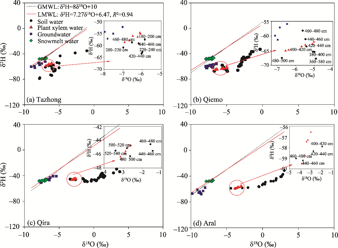
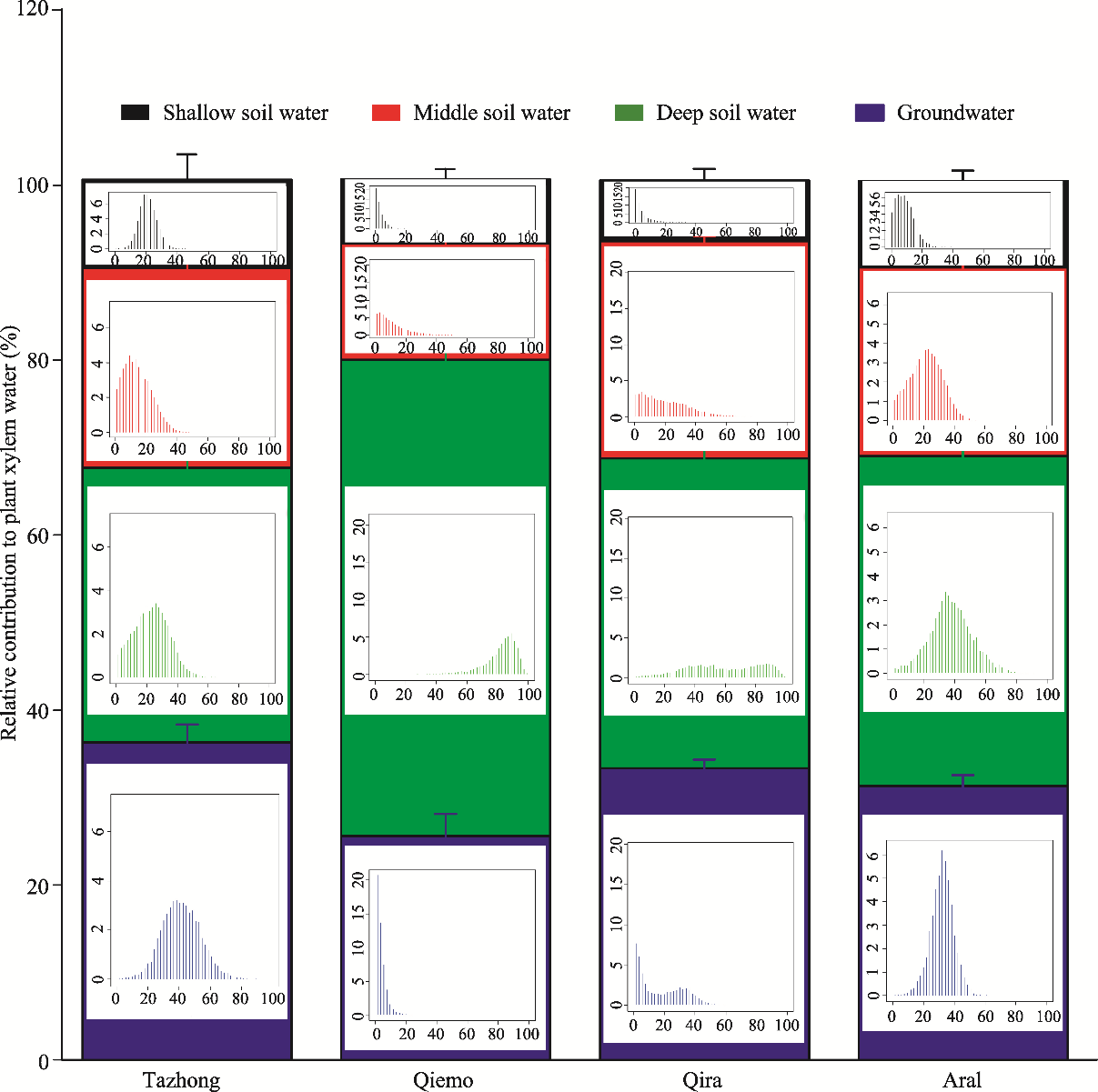
Abstract Tamarix taklamakanensis, a dominant species in the Taklimakan Desert of China, plays a crucial role in stabilizing sand dunes and maintaining regional ecosystem stability. This study aimed to determine the water use strategies of T. taklamakanensis in the Taklimakan Desert under a falling groundwater depth. Four typical T. taklamakanensis nabkha habitats (sandy desert of Tazhong site, saline desert-alluvial plain of Qiemo site, desert-oasis ecotone of Qira site and desert-oasis ecotone of Aral site) were selected with different climate, soil, groundwater and plant cover conditions. Stable isotope values of hydrogen and oxygen were measured for plant xylem water, soil water (soil depths within 0-500 cm), snowmelt water and groundwater in the different habitats. Four potential water sources for T. taklamakanensis, defined as shallow, middle and deep soil water, as well as groundwater, were investigated using a Bayesian isotope mixing model. It was found that groundwater in the Taklimakan Desert was not completely recharged by precipitation, but through the river runoff from snowmelt water in the nearby mountain ranges. The surface soil water content was quickly depleted by strong evaporation, groundwater depth was relatively shallow and the height of T. taklamakanensis nabkha was relatively low, thus T. taklamakanensis primarily utilized the middle (23%±1%) and deep (31%±5%) soil water and groundwater (36%±2%) within the sandy desert habitat. T. taklamakanensis mainly used the deep soil water (55%±4%) and a small amount of groundwater (25%±2%) within the saline desert-alluvial plain habitat, where the soil water content was relatively high and the groundwater depth was shallow. In contrast, within the desert-oasis ecotone in the Qira and Aral sites, T. taklamakanensis primarily utilized the deep soil water (35%±1% and 38%±2%, respectively) and may also use groundwater because the height of T. taklamakanensis nabkha was relatively high in these habitats and the soil water content was relatively low, which is associated with the reduced groundwater depth due to excessive water resource exploitation and utilization by surrounding cities. Consequently, T. taklamakanensis showed distinct water use strategies among the different habitats and primarily depended on the relatively stable water sources (deep soil water and groundwater), reflecting its adaptations to the different habitats in the arid desert environment. These findings improve our understanding on determining the water sources and water use strategies of T. taklamakanensis in the Taklimakan Desert.
|
|
Received: 08 May 2019
Published: 10 February 2020
|
|
Corresponding Authors:
|
| About author: *Corresponding author: LI Shengyu (E-mail: oasis@ms.xjb.ac.cn) |
|
|
| [1] |
Bruelheide H, Jandt U, Gries D, et al. 2003. Vegetation changes in a river oasis on the southern rim of the Taklamakan Desert in China between 1956 and 2000. Phytocoenologia, 33(4): 801-818.
|
|
|
| [2] |
Chen Y N, Cui W C, Li W H, et al. 2003. Utilization of water resources and ecological protection in the Tarim River. Acta Geographica Sinica, 58(2): 215-222. (in Chinese)
|
|
|
| [3] |
Cleverly J R, Dahm C N, Thibault J R, et al. 2002. Seasonal estimates of actual evapo-transpiration from Tamarix ramosissima stands using three-dimensional eddy covariance. Journal of Arid Environments, 52(2): 181-197.
|
|
|
| [4] |
Craig H. 1961. Isotopic variations in meteoric water. Science, 133(3465): 1702-1703.
|
|
|
| [5] |
Cui Y Q, Ma J Y, Sun W, et al. 2015. A preliminary study of water use strategy of desert plants in Dunhuang, China. Journal of Arid Land, 7(1): 73-81.
|
|
|
| [6] |
Dai Y, Zheng X J, Tang L Set al. 2015. Stable oxygen isotopes reveal distinct water use patterns of two Haloxylon species in the Gurbantonggut Desert. Plant and Soil, 389(1-2): 73-87.
|
|
|
| [7] |
Dawson T E, Mambelli S, Plamboeck A H. 2002. Stable isotopes in plant ecology. Annual Review of Ecology and Systematics, 33: 507-559.
|
|
|
| [8] |
Dong Z W, Zhao Y, Lei J Q, et al. 2018. Distribution pattern and influencing factors of soil salinity at Tamarix cones in the Taklimakan Desert. Chinese Journal of Plant Ecology, 42(8): 873-884. (in Chinese)
|
|
|
| [9] |
Ehleringer J R, Dawson T E. 1992. Water uptake by plants: perspectives from stable isotope composition. Plant Cell and Environment, 15(9): 1073-1082.
|
|
|
| [10] |
Evaristo J, McDonnell J J, Scholl M A, et al. 2016. Insights into plant water uptake from xylem-water isotope measurements in two tropical catchments with contrasting moisture conditions. Hydrological Processes, 30(18): 3210-3227.
|
|
|
| [11] |
Fan J L, Jin X J, Lei J Q, et al. 2013. Responses of ground water level to pumping water of the Tarim Desert Highway shelterbelt project. Chinese Agricultural Science Bulletin, 29(2): 114-119. (in Chinese)
|
|
|
| [12] |
Gat J R, Yakir D, Goodfriend G, et al. 2007. Stable isotope composition of water in desert plants. Plant and Soil, 298(1-2): 31-45.
|
|
|
| [13] |
Gong W H, Wang Y G, Gao Q Z, et al. 2011. Ecological comprehensive monitoring for Aral Station in Tarim River Basin. Arid Land Geography, 34(5): 762-771. (in Chinese)
|
|
|
| [14] |
Gries D, Zeng F, Foetzki A, et al. 2003. Growth and water relations of Tamarix ramosissima and Populus euphratica on Taklamakan desert dunes in relation to depth to a permanent water table. Plant Cell and Environment, 26(5): 725-736.
|
|
|
| [15] |
Horton J L, Clark J L. 2001. Water table decline alters growth and survival of Salix gooddingii and Tamarix chinensis seedlings. Forest Ecology and Management, 140(2-3): 239-247.
|
|
|
| [16] |
Li H S, Wang W F, Zhan H T, et al. 2010. New judgement on the source of soil water in extremely dry zone. Acta Ecologica Sinica, 30(1): 1-7.
|
|
|
| [17] |
Li S Y, Tang Q L, Lei J Q, et al. 2015. An overview of non-conventional water resource utilization technologies for biological sand control in Xinjiang, northwest China. Environment Earth Science, 73(2): 873-885.
|
|
|
| [18] |
Li X Y, Lin L S, Zhao Q. 2009. Distribution of dominant plant species and characteristic of its communities on the foreland of Cele oasis in relation to groundwater level. Arid Land Geography, 32(6): 906-911. (in Chinese)
|
|
|
| [19] |
Liu X P, Zhang T H, Zhao H L, et al. 2006. Infiltration and redistribution process of rainfall in desert mobile sand dune. Journal of Hydraulic Engineering, 37(2): 166-171. (in Chinese)
|
|
|
| [20] |
Liu X Y, Mao J T, Zhang F, et al. 2012. The analysis of water vapor distribution over Taklimakan Desert. Science China Earth Sciences, 55(3): 446-455. (in Chinese)
|
|
|
| [21] |
Mathieu R, Bariac T. 1996. An isotopic study (2H and 18O) of water movements in clayey soils under a semiarid climate. Water Resources Research, 32(4): 779-790.
|
|
|
| [22] |
Muhtar Q, Hiroki T, Mijit H. 2002. Formation and internal structure of Tamarix cones in the Taklimakan Desert. Journal of Arid Environments, 50(1): 81-97.
|
|
|
| [23] |
Parnell A C, Inger R, Bearhop S, et al. 2010. Source partitioning using stable isotopes: coping with too much variation. PloS ONE, 5: e9672.
|
|
|
| [24] |
Rosenthal D M, Ludwig F, Donovan L A. 2005. Plant responses to an edaphic gradient across an active sand dune/desert boundary in the Great Basin Desert. International Journal of Plant Sciences, 166(2): 247-255.
|
|
|
| [25] |
Schachtschneider K, February E C. 2010. The relationship between fog, floods, groundwater and tree growth along the lower Kuiseb River in the hyperarid Namib. Journal of Arid Environments, 74(12): 1632-1637.
|
|
|
| [26] |
Schultz N M, Griffis T J, Lee X H, et al. 2011. Identification and correction of spectral contamination in 2H/1H and 18O/16O measured in leaf, stem, and soil water. Rapid Communications in Mass Spectrometry, 25(21): 3360-3368.
|
|
|
| [27] |
Si J H, Feng Q, Cao S, et al. 2014. Water use sources of desert riparian Populus euphratica forests. Environmental Monitoring and Assessment, 186(9): 5469-5477.
|
|
|
| [28] |
Sun J M, Liu T S. 2006. The age of the Taklimakan Desert. Science, 312(5780): 1621, doi: 10.1126/science.1124616.
|
|
|
| [29] |
Sun Z Y, Long X, Ma R. 2016. Water uptake by saltcedar (Tamarix ramosissima) in a desert riparian forest: responses to intra-annual water table fluctuation. Hydrological Processes, 30(9): 1388-1402.
|
|
|
| [30] |
Thomas T W. 2008. Desert Meteorology. New York: Cambridge University Press, 136: 143-151.
|
|
|
| [31] |
Tiemuerbieke B, Min X J, Zang Y X, et al. 2018. Water use patterns of co-occurring C3 and C4 shrubs in the Gurbantonggut desert in northwestern China. Science of The Total Environment, 634: 341-354.
|
|
|
| [32] |
Wang S G, Wang J Y, Zhou Z J, et al. 2005. Regional characteristics of three kinds of dust storm events in China. Atmospheric Environment, 39(3): 509-520.
|
|
|
| [33] |
Wang Y Y, Chen Y P, Li W H, et al. 2017. Water sources of typical desert riparian plants in the lower reaches of Tarim River. Journal of Desert Research, 37(6): 1150-1157. (in Chinese)
|
|
|
| [34] |
Wu H W, Li X Y, Jiang Z Y, et al. 2016. Contrasting water use pattern of introduced and native plants in an alpine desert ecosystem, Northeast Qinghai-Tibet Plateau, China. Science of The Total Environment, 542: 182-191.
|
|
|
| [35] |
Wu Y, Zhou H, Zheng X J, et al. 2014. Seasonal changes in the water use strategies of three co-occurring desert shrubs. Hydrological Processes, 28(26): 6265-6275.
|
|
|
| [36] |
Xia X C, Zhao Y J, Wang F B. 2004. Stratification features of Tamarix cone and its possible age significance. Chinese Science Bulletin, 49(14): 1539-1540. (in Chinese)
|
|
|
| [37] |
Yakir D, Yechieli Y. 1995. Plant invasion of newly exposed hypersaline Dead Sea shores. Nature, 374: 803-805.
|
|
|
| [38] |
Zeng F J, Song C, Guo H, et al. 2013. Responses of root growth of Alhagi sparsifolia Shap. (Fabaceae) to different simulated groundwater depths in the southern fringe of the Taklimakan Desert, China. Journal of Arid Land, 5(2): 220-232.
|
|
|
| [39] |
Zhang D Y, Pan B R, Yin L K. 2003. The photo geographical studies of Tamarix (Tamaricaceae). Acta Botanica Yunnanica, 25: 415-427. (in Chinese)
|
|
|
| [40] |
Zhang J H, Wang N A, Niu Z M, et al. 2018. Stable isotope analysis of water sources for Tamarix laxa in the mega-dunes of the Badain Jaran Desert, China. Journal of Arid Land, 10(6): 821-832.
|
|
|
| [41] |
Zhao J B, Ma Y D, Xing S H, et al. 2010. Study on moisture content in sand layers of Tengger Desert in Zhongwei, Ningxia. Journal of Mountain Science, 28(6): 653-659. (in Chinese)
|
|
|
| [42] |
Zhou H, Zheng X J, Tang L S, et al. 2013. Differences and similarities between water sources of Tamarix ramosissima, Nitraria sibirica and Reaumuria soongorica in the southeastern Junggar Basin. Chinese Journal of Plant Ecology, 37(7): 665-673. (in Chinese)
|
|
|
| [43] |
Zhou T H, Zhao C Y, Wu G L, et al. 2017. Application of stable isotopes in analyzing the water source of Populus euphratica and Tamarix ramosissima in the upstream of Tarim River. Journa1 of Desert Research, 37(1): 124-131. (in Chinese)
|
|
|
|
Viewed |
|
|
|
Full text
|
|
|
|
|
Abstract
|
|
|
|
|
Cited |
|
|
|
|
| |
Shared |
|
|
|
|
| |
Discussed |
|
|
|
|