| Research article |
|

|
|
|
| Uncertainty assessment of potential evapotranspiration in arid areas, as estimated by the Penman-Monteith method |
HUA Ding1,2, HAO Xingming1,2,*( ), ZHANG Ying1,2, QIN Jingxiu1,2 ), ZHANG Ying1,2, QIN Jingxiu1,2 |
1 State Key Laboratory of Desert and Oasis Ecology, Xinjiang Institute of Ecology and Geography, Chinese Academy of Sciences, Urumqi 830011, China
2 University of Chinese Academy of Sciences Beijing 100049, China |
|
|
|
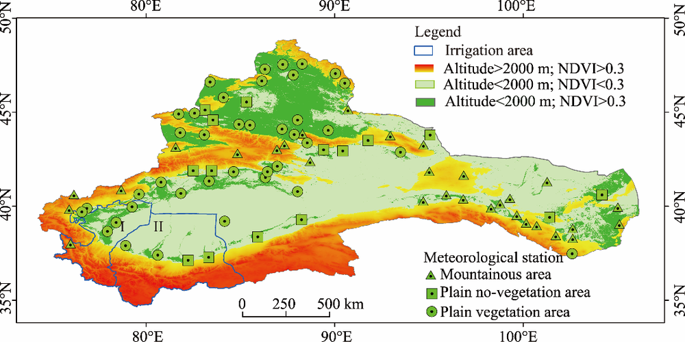
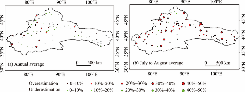
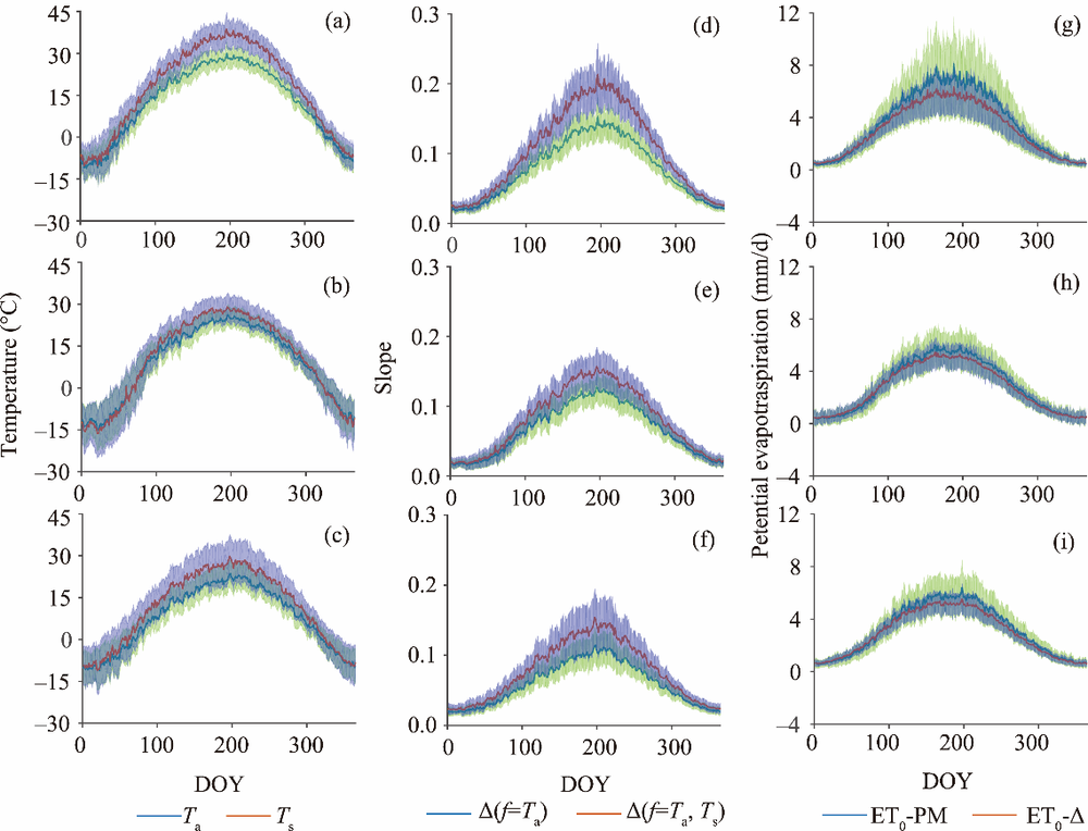
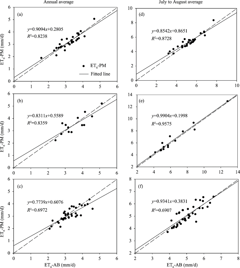
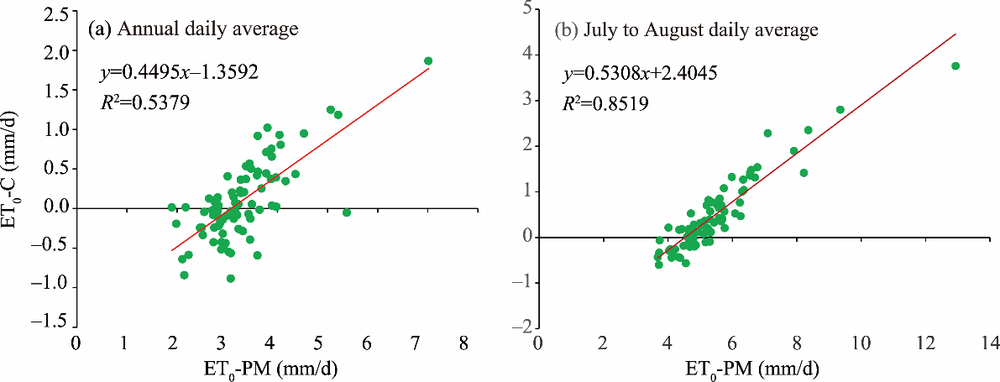
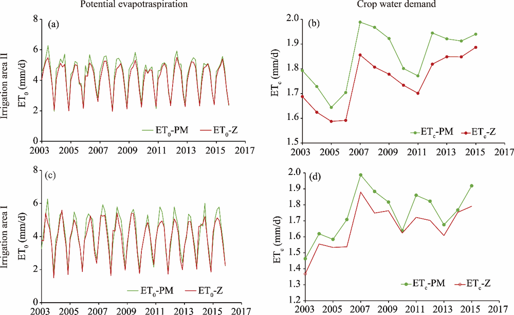
Abstract The Penman-Monteith (PM) method is the most widely used technique to estimate potential worldwide evapotranspiration. However, current research shows that there may be significant errors in the application of this method in arid areas, although questions remain as to the degree of this estimation error and how different surface conditions may affect the estimation error. To address these issues, we evaluated the uncertainty of the PM method under different underlying conditions in an arid area of Northwest China by analyzing data from 84 meteorological stations and various Moderate Resolution Imaging Spectroradiometer (MODIS) products, including land surface temperature and surface albedo. First, we found that when the PM method used air temperature to calculate the slope of the saturation vapor pressure curve, it significantly overestimated the potential evapotranspiration; the mean annual and July-August overestimation was 83.9 and 36.7 mm, respectively. Second, the PM method usually set the surface albedo to a fixed value, which led to the potential evapotranspiration being underestimated; the mean annual underestimation was 27.5 mm, while the overestimation for July to August was 5.3 mm. Third, the PM method significantly overestimated the potential evapotranspiration in the arid area. This difference in estimation was closely related to the underlying surface conditions. For the entire arid zone, the PM method overestimated the potential evapotranspiration by 33.7 mm per year, with an overestimation of 29.0 mm from July to August. The most significant overestimation was evident in the mountainous and plain non-vegetation areas, in which the annual mean overestimation reached 5% and 10%, respectively; during July, there was an estimation of 10% and 20%, respectively. Although the annual evapotranspiration of the plains with better vegetation coverage was slightly underestimated, overestimation still occurred in July and August, with a mean overestimation of approximately 5%. In order to estimate potential evapotranspiration in the arid zone, it is important that we identify a reasonable parameter with which to calibrate the PM formula, such as the slope of the saturation vapor pressure curve, and the surface albedo. We recommend that some parameters must be corrected when using PM in order to estimate potential evapotranspiration in arid regions.
|
|
Received: 13 May 2019
Published: 10 February 2020
|
|
Corresponding Authors:
|
| About author: *Corresponding author: HAO Xingming (E-mail: haoxm@ms.xjb.ac.cn) |
|
|
| [1] |
Ali M H, Adham A K M, Rahman M M, et al. 2009. Sensitivity of Penman-Monteith estimates of reference evapotranspiration to errors in input climatic data. Journal of Agrometeorology, 11(1): 1-8.
|
|
|
| [2] |
Allen R G, Pereira L G, Raes S M. 1998. Crop evapotranspiraion guidelines for computing crop water requirements. FAO Irrigation and Drainage Paper No.56. FAO. Rome, Italy.
|
|
|
| [3] |
Allen R G, Pruitt W O, Wright J L, et al. 2006. A recommendation on standardized surface resistance for hourly calculation of reference ET0 by the FAO56 Penman-Monteith method. Agricultural Water Management, 81(1-2): 1-22.
|
|
|
| [4] |
Anabalón A, Sharma A. 2017. On the divergence of potential and actual evapotranspiration trends: An assessment across alternate global datasets. Earth Future, 5(9): 905-917.
|
|
|
| [5] |
Chen J E, Zuo H C, Wang Y, et al. 2014. Parameterization scheme about albedo changing with solar altitude angle over different underlying surface in arid areas of Northwest China. Plateau Meteorology, 33(1): 80-88. (in Chinese)
|
|
|
| [6] |
Chen N N, Zhang Y S, Jin C J, et al. 2018. Intercomparison of three methods to estimate evapotranspiration over temperate meadow in Inner Mongolia: Penman-Monteith, Makkink and Priestley-Taylor equation. Water and Environment, 32(4): 500-507.
|
|
|
| [7] |
Chen Y, Li Z, Fan Y T, et al. 2015. Progress and prospects of climate change impacts on hydrology in the arid region of Northwest China. Environmental Research, 139: 11-19.
|
|
|
| [8] |
Chen Y, Li B F, Li Z, et al. 2016. Water resource formation and conversion and water security in arid region of Northwest China. Journal of Geographical Sciences, 26(7): 939-952.
|
|
|
| [9] |
Ci J H, Feng Q, Zhang X Y, et al. 2005. Research progress on surveying and calculation of evapotranspiration of plants and its prospects. Advances in Water Science, 16(3): 450-459.
|
|
|
| [10] |
Dhungel R, Allen R G, Trezza R, et al. 2014. Comparison of latent heat flux using aerodynamic methods and using the penman-monteith method with satellite-based surface energy balance. Remote Sensing, 6(9): 8844-8877.
|
|
|
| [11] |
Ficklin D L, Letsinger S L, Ghoilzadeh H, et al. 2014. Incorporation of the Penman-Monteith potential evapotranspiration method into a Palmer Drought Severity Index Tool. Computers & Geosciences, 85: 136-141.
|
|
|
| [12] |
Fugazza D, Senese A, Azzoni R S, et al. 2016. Spatial distribution of surface albedo at the Forni Glacier (Stelvio National Park, Central Italian Alps). Cold Regions Science and Technology, 125: 128-137.
|
|
|
| [13] |
Hao X M, Zhang S H, Li W H, et al. 2018. The uncertainty of Penman-Monteith method and the energy balance closure problem. Journal of Geophysical Research-Atmospheres, 123(14): 7433-7443.
|
|
|
| [14] |
Heidi W, Thomas G, Roelof O, et al. 2016. Uncertainty in future irrigation water demand and risk of crop failure for maize in Europe. Environmental Research Letters, 11(7): 074007, doi:10.1088/1748-9326/11/7/074007.
|
|
|
| [15] |
Koffi D, Michael O, Curtis O, et al. 2018. Crop evapotranspiration, irrigation water requirement and water productivity of maize from meteorological data under semiarid climate. Water, 10(4): 405, doi: 10.3390/w10040405.
|
|
|
| [16] |
Li L, Chi D C, Zhang Z L, et al. 2007. Analysis of the change characteristics and effect factors of reference evapotranspiration in Taizi River Basin. Transactions of the Chinese Society of Agricultural Engineering, 23(9): 34-38. (in Chinese)
|
|
|
| [17] |
Li W L, Lu S H, Fu S M, et al. 2011. Numerical simulation of fluxes generated by inhomogeneities of the underlying surface over the Jinta Oasis in Northwestern China. Advances in Atmospheric Sciences, 28(4): 887-906.
|
|
|
| [18] |
Li X G, Bi H X, Liu S, et al. 2005. Penman-Monteith evapotranspiration model and calculations of its parameters in forest underlying surface. Research of Soil and Water Conservation, 12(5): 257-261. (in Chinese)
|
|
|
| [19] |
Li Z, Chen Y, Shen Y, et al. 2013. Analysis of changing pan evaporation in the arid region of Northwest China. Water Resources Research, 49(4): 2205-2212.
|
|
|
| [20] |
Liu B, Hu J C, Zhao X L, et al. 2015. Error analysis on evapotranspiration estimation of paddy rice field by Penman-Monteith model. Chinese Journal of Agrometeorology, 36(1): 24-32. (in Chinese)
|
|
|
| [21] |
Mallick K, Andrew J, Eva B, et al. 2014. A Surface Temperature Initiated Closure (STIC) for surface energy balance fluxes. Remote Sensing of Environment, 141: 243-261.
|
|
|
| [22] |
Otles Z, Gutowski W. 2005. Atmospheric stability effects on Penman-Monteith evapotranspiration estimates. Pure and Applied Geophysics, 162(11): 2239-2254.
|
|
|
| [23] |
Oudin L, Perrin C, Mathevet T, et al. 2006. Impact of biased and randomly corrupted inputs on the efficiency and the parameters of watershed models. Journal of Hydrology, 320(1-2): 62-83.
|
|
|
| [24] |
Parajuli P B, Jayakody P, Ouyang Y. 2018. Evaluation of using remote sensing evapotranspiration data in swat. Water Resources Management, 32(3): 985-996.
|
|
|
| [25] |
Peng H, Jia Y W, Qiu Y Q, et al. 2013. Assessing climate change impacts on the ecohydrology of the Jinghe River basin in the Loess Plateau, China. Hydrological Sciences Journal, 68(3): 651-670.
|
|
|
| [26] |
Penman H L. 1948. Nature evaporation from open water, bare soil and grass. Proceedings of the Royal A, 193(1032): 120-145.
|
|
|
| [27] |
Raoufi R, Beighley E. 2017. Estimating daily global evapotranspiration using Penman-Monteith equation and remotely sensed land surface temperature. Remote Sensing, 9(11): 1138, doi: 10.3390/rs9111138.
|
|
|
| [28] |
Samain B, Pauwels V R N. 2013. Impact of potential and (scintillometer-based) actual evapotranspiration estimates on the performance of a lumped rainfall-runoff model. Hydrology and Earth System Sciences, 17(11): 4525-4540.
|
|
|
| [29] |
Shen S H, Leptoukh G G. 2011. Estimation of surface air temperature over central and eastern Eurasia from Modis land surface temperature. Environmental Research Letters, 6(4): 045206, doi:10.1088/1748-9326/6/4/045206.
|
|
|
| [30] |
Shen Y J, Chen Y N, Qi Y Q, et al. 2013. Estimation of regional irrigation water requirement and water supply risk in the arid region of Northwestern China 1989-2010. Agricultural Water Management, 128(1): 55-64.
|
|
|
| [31] |
Sun L, Liang S L, Yuan W P, et al. 2013. Improving a Penman-Monteith evapotranspiration model by incorporating soil moisture control on soil evaporation in semiarid areas. International Journal of Digital Earth, 6(S1): 134-156.
|
|
|
| [32] |
Tegos A, Malamos N, Efstratiadis A.et al. 2017. Parametric modelling of potential evapotranspiration: a global survey. Water, 9(10): 795, .
|
|
|
| [33] |
Temesgen B, Eching S, Davidoff B. 2005. Comparison of some reference evapotranspiration equations for California. Journal of Irrigation and Drainage Engineering, 131(1): 73-84.
|
|
|
| [34] |
Tirivarombo S, Osupile D, Eliasson P. 2018. Drought monitoring and analysis: Standardised Precipitation Evapotranspiration Index (SPEI) and Standardised Precipitation Index (SPI). Physics and Chemistry of the Earth, Parts A/B/C, 106: 1-10.
|
|
|
| [35] |
Wan Z, Li Z L. 2008. Radiance-based validation of the V5 MODIS land-surface temperature product. International Journal of Remote Sensing, 29(17-18): 5373-5395.
|
|
|
| [36] |
Wang H B, Ma M G. 2014. Estimation of transpiration and evaporation of different ecosystems in an inland river basin using remote sensing data and the Penman-Monteith equation. Acta Ecologica Sinica, 34(19): 5617-5626. (in Chinese)
|
|
|
| [37] |
Wei X, Wei Z W, Wen X F. 2018. Evapotranspiration partitioning at the ecosystem scale using the stable isotope method-A review. Agricultural and Forest Meteorology, 263: 346-361.
|
|
|
| [38] |
Westerhoff R S. 2015. Using uncertainty of Penman and Penman-Monteith methods in combined satellite and ground-based evapotranspiration estimates. Remote Sensing of Environment, 169: 102-112.
|
|
|
| [39] |
Xu C Y, Singh V P. 2001. Evaluation and generalization of temperature-based methods for calculating evaporation. Hydrological Processes, 15(2): 305-319.
|
|
|
| [40] |
Zhang F H. 2003. Oasis agriculture characters and development in arid area of Northewestern China. Journal of Arid Land Resources & Environment, 17(4): 19-23. (in Chinese)
|
|
|
| [41] |
Zhang J, Sun F, Xu J. 2015. Dependence of trends in and sensitivity of drought over China (1961-2013) on potential evaporation model. Geophysical Research Letters, 43(1): 206-213.
|
|
|
| [42] |
Zhang R H, Du J P, Sun R. 2012. Review of estimation and validation of regional evapotranspiration based on remote sensing. Advance in Earth Sciences, 27(12): 1295-1307. (in Chinese)
|
|
|
| [43] |
Zhao L L, Xia J, Xu C Y, et al. 2013. A review of evapotranspiration estimation methodsin hydrological Models. Journal of Geographical Sciences, 68(1): 127-136.
|
|
|
| [44] |
Zhao W Z, Ji X B, Kang E S, et al. 2010. Evaluation of Penman-Monteith model applied to a maize field in the arid area of Northwest China. Hydrology and Earth System Sciences, 14(7): 1353-1364.
|
|
|
|
Viewed |
|
|
|
Full text
|
|
|
|
|
Abstract
|
|
|
|
|
Cited |
|
|
|
|
| |
Shared |
|
|
|
|
| |
Discussed |
|
|
|
|