Region-wide glacier area and mass budgets for the Shaksgam River Basin, Karakoram Mountains, during 2000-2016
WANG Panpan1, LI Zhongqin1,2,*(), XU Chunhai2, WANG Puyu2
1College of Geography and Environmental Science, Northwest Normal University, Lanzhou 730070, China 2State Key Laboratory of Cryospheric Sciences/Tianshan Glaciological Station, Northwest Institute of Eco-Environment and Resources, Chinese Academy of Sciences, Lanzhou 730000, China
The Karakoram Mountains are well known for their widespread surge-type glaciers and slight glacier mass gains. On the one hand, glaciers are one of the sensitive indicators of climate change, their area and thickness will adjust with climate change. On the other hand, glaciers provide freshwater resources for agricultural irrigation and hydroelectric generation in the downstream areas of the Shaksgam River Basin (SRB) in western China. The shrinkage of glaciers caused by climate change can significantly affect the security and sustainable development of regional water resources. In this study, we analyzed the changes in glacier area from 2000 to 2016 in the SRB using Landsat TM (Thematic Mapper)/ETM+ (Enhanced Mapper Plus)/OLI (Operational Land Imager) images. It is shown that the SRB contained 472 glaciers, with an area of 1840.3 km 2, in 2016. The glacier area decreased by 0.14%/a since 2000, and the shrinkage of glacier in the southeast, east and south directions were the most, while the northeast, north directions were the least. Debris-covered area accounted for 8.0% of the total glacier area. We estimated elevation and mass changes using the 1 arc-second SRTM (Shuttle Radar Topography Mission) DEM (Digital Elevation Model) (2000) and the resolution of 8 m HMA (High Mountain Asia) DEM (2016). An average thickness of 0.08 (±0.03) m/a, or a slight mass increase of 0.06 (±0.02) m w.e./a has been obtained since 2000. We found thinning was significantly lesser on the clean ice than the debris-covered ice. In addition, the elevation of glacier surface is spatially heterogeneous, showing that the accumulation of mass is dominant in high altitude regions, and the main mass loss is in low altitude regions, excluding the surge-type glacier. For surge-type glaciers, the mass may transfer from the reservoir to the receiving area rapidly when surges, then resulting in an advance of glacier terminus. The main surge mechanism is still unclear, it is worth noting that the surge did not increase the glacier mass in this study.
WANG Panpan, LI Zhongqin, XU Chunhai, WANG Puyu. Region-wide glacier area and mass budgets for the Shaksgam River Basin, Karakoram Mountains, during 2000-2016. Journal of Arid Land, 2021, 13(2): 175-188.
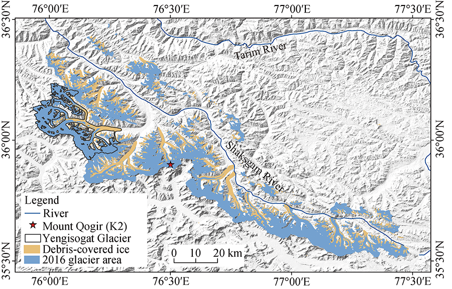
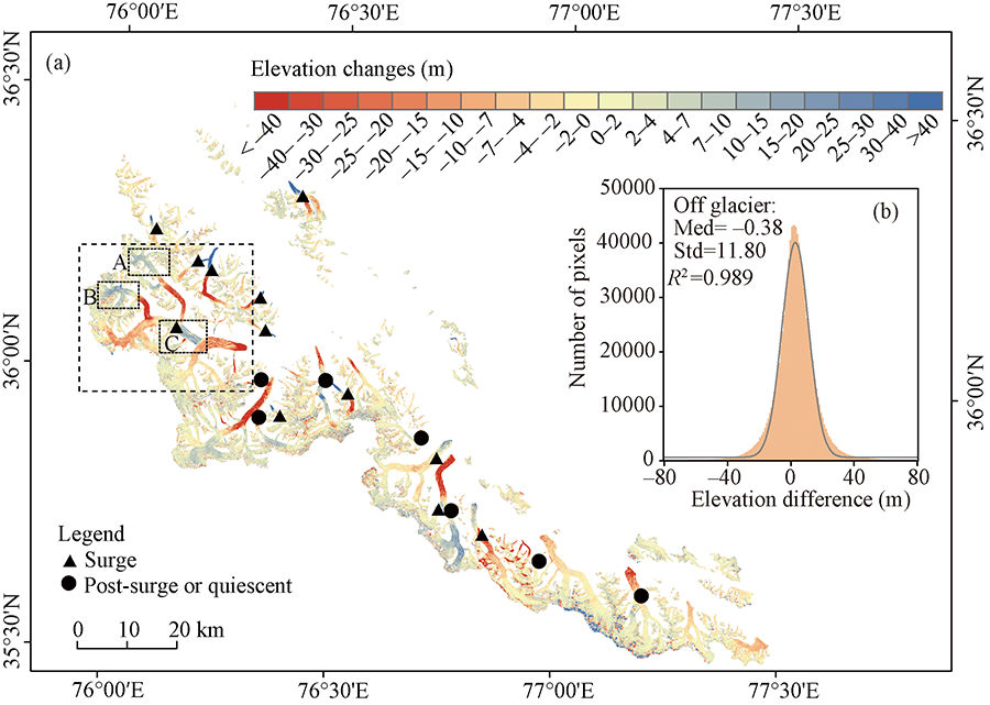
Fig. 1Location of the study area and distribution of glaciers in 2016. The background map is hillshade of SRTM (Shuttle Radar Topography Mission) DEM (Digital Elevation Model). The debris-covered ice was from Nico et al. (2018).
Satellite sensor
Period of data
Path/Row
Cloud (%)
Spatial resolution (m)
Landsat TM
29 Aug 1998
148/35
4
30
Landsat TM
4 Sep 2000
148/35
8
30
Landsat ETM+
16 Jul 1999
148/35
13
15/30
Landsat ETM+
16 Jun 2000
148/35
2
15/30
Landsat ETM+
21 Jul 2001
148/35
6
15/30
Landsat ETM+
22 Jun 2002
148/35
3
15/30
Landsat OLI
4 Jul 2015
148/35
3
15/30
Landsat OLI
24 Sep 2016
148/35
6
15/30
Table 1 Remote sensing images used in this study
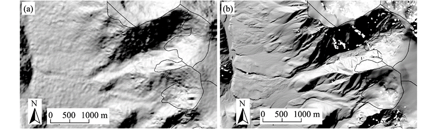
Fig. 2Resolution comparison of the two DEMs. (a), the 1 arc-second SRTM DEM from 2000; (b), the 8 m HMA (High Mountain Asia) DEM from 2015. The white spots in (b) are voids. The black line cycled areas were glaciers and both pictures were from Paul et al. (2019).
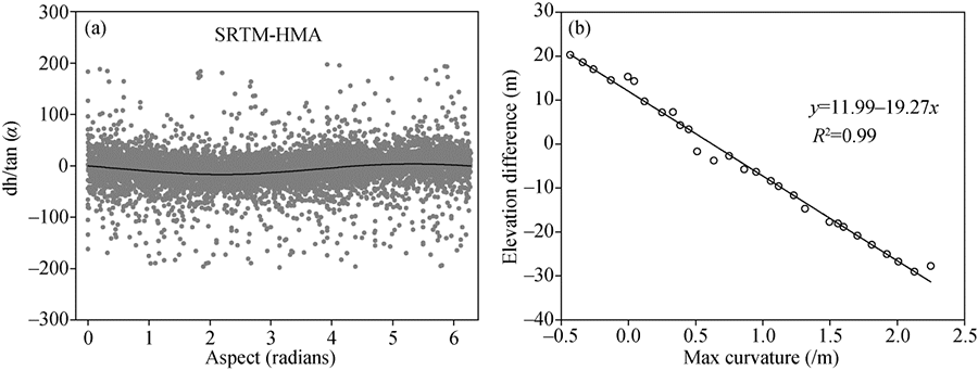
Fig. 3(a) Scatter plot of aspect vs slope for the standardized elevation differences for non-glacier areas. (b) Relationship between elevation difference and maximum curvature in the non-glacier areas of SRB (Shaksgam River Basin).
Before co-registration
After co-registration
N
Eσ(m)
E(m)
Em(m)
SDno glac(m)
Em(m)
SDno glac
-19.83
14.91
-0.38
11.80
6960
0.14
0.41
Table 2 Statistical results of the vertical error before and after the adjustment of the HMA (High Mountain Asia) and SRTM (Shuttle Radar Topography Mission) DEMs (Digital Elevation Models) in non-glacier areas
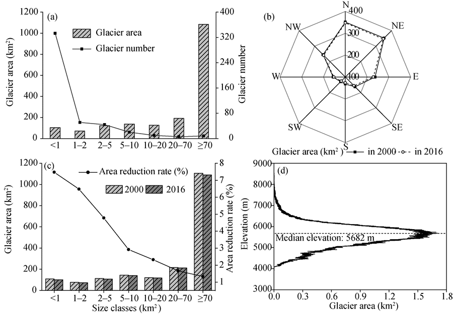
Fig. 4Glacier distribution and change in the SRB. (a), area and number of 2016 glaciers in different size classes; (b), distribution of glacier area in different slope directions in 2000 and 2016; (c), the change of glacier area and area reduction rate under different size classes from 2000 to 2016; (d), the distribution of glacier area with elevation in 2016.
Fig. 5Changes in glacier surface elevation in the SRB from 2000 to 2016. The glacier boundaries are based on the union of the 2000 and 2016 glacier area. These surge-type glacier and post-surge or quiescent during 1999-2011 were reported by Gardelle et al. (2012a, 2013).
Region
Study period
Elevation change (m/a)
Mass balance (m w.e./a)
Reference
Karakoram Mountains
2003-2008
-0.07 (±0.04)
-0.06 (±0.04)
K??b et al. (2012)
Karakoram Mountains
2003-2009
-0.12 (±0.15)
-
Gardner et al. (2013)
Central Karakoram
2000-2010
0.12 (±0.19)
0.10 (±0.16)
Gardelle et al. (2013)
Central Karakoram
2000-2012
-0.09 (±0.12)
-0.08 (±0.10)
Rankl and Braun (2016)
Central Karakoram
1999-2008
-
0.11 (±0.22)
Gardelle et al. (2012a)
SRB
2000-2016
0.08 (±0.03)
0.06 (±0.02)
This study
Table 3 Comparison of mass balance budgets in this study and others
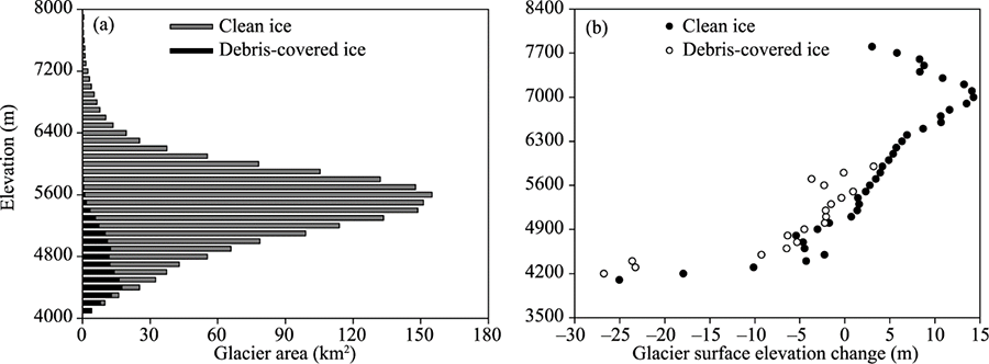
Fig. 6Distribution of glacier area in 2016 (a) and glacier surface elevation changes during 2000-2016 (b) at 100-m intervals by elevation in the SRB for debris-covered ice and clean ice
[1]
Albert T H. 2002. Evaluation of remote sensing techniques for ice-area classification applied to the tropical Quelccaya Ice Cap, Peru. Polar Geography, 26(3):210-226.
[2]
Archer D R, Fowler H J. 2004. Spatial and temporal variations in precipitation in the Upper Indus Basin, global teleconnections and hydrological implications. Hydrology and Earth System Sciences, 8(1):47-61.
[3]
Bader H. 1954. Sorge's law of densification of snow on high polar glaciers. Journal of Glaciology, 2(15):319-323.
[4]
Bashir F, Zeng X B, Gupta H, et al. 2017. A hydrometeorological perspective on the Karakoram anomaly using unique valley-based synoptic weather observations. Geophysical Research Letters, 44(20):10470-10478.
[5]
Benn D I, Lehmkuhl F. 2000. Mass balance and equilibrium-line altitudes of glaciers in high-mountain environments. Quaternary International, 65- 66:15-29.
[6]
Berthier E, Brun F. 2019. Karakoram geodetic glacier mass balances between 2008 and 2016: persistence of the anomaly and influence of a large rock avalanche on Siachen Glacier. Journal of Glaciology, 65(251):494-507.
[7]
Bhambri R, Hewitt K, Kawishwar P, et al. 2017. Surge-type and surge-modified glaciers in the Karakoram. Scientific Reports, 7(1):15391, doi: 10.1038/s41598-017-15473-8.
doi: 10.1038/s41598-017-15473-8
pmid: 29133812
[8]
Bolch T, Menounos B, Wheate R, et al. 2010. Landsat-based inventory of glaciers in western Canada, 1985-2005. Remote Sensing of Environment, 114(1):127-137.
[9]
Bolch T, Pieczonka T, Benn D I. 2011. Multi-decadal mass loss of glaciers in the Everest area (Nepal Himalaya) derived from stereo imagery. The Cryosphere, 5:349-358.
[10]
Bolch T, Kulkarni A, Kääb A, et al. 2012. The state and fate of Himalayan glaciers. Science, 336(6079):310-314.
pmid: 22517852
[11]
Brun F, Berthier E, Wagnon P, et al. 2017. A spatially resolved estimate of High Mountain Asia glacier mass balances from 2000 to 2016. Nature Geoscience, 10(9):668-658.
doi: 10.1038/NGEO2999
pmid: 28890734
[12]
Cannon F, Carvalho L M V, Jones C, et al. 2015. Multi-annual variations in winter westerly disturbance activity affecting the Himalaya. Climate Dynamics, 44(1-2):441-455.
[13]
Chen A A, Li Zhe, He J Q, et al. 2018. Study of penetration depth for the SRTM C-band DEM in the glacier area over the High Mountain Asia. Journal of Glaciology and Geocryology, 40(1):26-37.
[14]
Cogley G J. 2011. Present and future states of Himalaya and Karakoram glaciers. Annals of Glaciology, 52(59):69-73.
[15]
Elsberg D H, Harrison W D, Echelmeyer K A, et al. 2001. Quantifying the effects of climate and surface change on glacier mass balance. Journal of Glaciology, 47(159):649-658.
[16]
Farr T G, Rosen P A, Caro E, et al. 2007. The shuttle radar topography mission. Reviews of Geophysics, 45(2):361.
[17]
Fischer A. 2011. Comparision of direct and geodetic mass balances on a multi-annual time scale. Cryosphere Discussions, 5(1):565-604.
[18]
Forsythe N, Hardy A J, Fowler H J, et al. 2015. A detailed cloud fraction climatology of the upper indus basin and its implications for near-surface air temperature. Journal of Climate, 28(9), 3537-3556.
[19]
Forsythe N, Fowler H J, Li X F, et al. 2017. Karakoram temperature and glacial melt driven by regional atmospheric circulation variability. Nature Climate Change, 7:664-670.
[20]
Fowler H J, Archer D R. 2010. Conflicting signals of climatic change in the Upper Indus Basin. Journal of Climate, 19(17):4276-4293.
[21]
Gardelle J, Berthier E, Arnaud Y. 2012a. Slight mass gain of Karakoram glaciers in the early twenty-first century. Nature Geoscience, 5(5):322-325.
[22]
Gardelle J, Berthier E, Arnaud Y. 2012b. Impact of resolution and radar penetration on glacier elevation changes computed from DEM differencing. Journal of Glaciology, 58(208):419-422.
[23]
Gardelle J, Berthier E, Arnaud Y, et al. 2013. Region-wide glacier mass balances over the Pamir-Karakoram-Himalaya during 1999-2011. The Cryosphere, 7(4):1263-1286.
[24]
Gardner A S, Moholdt G, Cogley J G, et al. 2013. A reconciled estimate of glacier contributions to sea level rise: 2003 to 2009. Science, 340(6134):852-857.
pmid: 23687045
[25]
He Y, Yang T. 2014. Climate variation and glacier response in the Bogda region, Tianshan Mountains. Progress in Geography, 33(10):1387-1396. (in Chinese)
[26]
Hewitt K. 2005. The Karakoram Anomaly? Glacier expansion and the 'Elevation Effect', Karakoram Himalaya. Mountain Research Development, 25(4):332-340.
[27]
Huss M. 2013. Density assumptions for converting geodetic glacier volume change to mass change. The Cryosphere, 7(7):877-887.
[28]
IPCC (ntergovernmental Panel on Climate Change). 2013. Climate Change 2013: The Physical Science Basis. Contribution of Working Group I to the Fifth Assessment Report of the Intergovernmental Panel on Climate Change. Cambridge: Cambridge University Press, 1535.
[29]
Janes T J, Bush A B G. 2012. The role of atmospheric dynamics and climate change on the possible fate of glaciers in the Karakoram. Journal of Climate, 25(23):8308-8327.
[30]
Jiang Z L, Wang L, Zhang Z, et al. 2020. Surface elevation changes of Yengisogat Glacier between 2000 and 2014. Arid Land Geography, 43(1):12-19. (in Chinese)
[31]
Jin R, Li X, Che T, et al. 2005. Glacier area changes in the Pumqu river basin, Tibetan Plateau, between the 1970s and 2001. Journal of Glaciology, 51(175):607-610.
[32]
Kääb A. 2005. Remote Sensing of Mountain Glaciers and Permafrost Creep. Switzerland: Schriftenreihe Physische Geographie, 48:266.
[33]
Kääb A, Berthier E, Nuth C, et al. 2012. Contrasting patterns of early twenty-first-century glacier mass change in the Himalayas. Nature, 488(7412):495-498.
doi: 10.1038/nature11324
pmid: 22914167
[34]
Kääb A, Treichler D, Nuth C, et al. 2015. Brief communication: contending estimates of 2003-2008 glacier mass balance over the Pamir-Karakoram-Himalaya. Cryosphere, 9:557-564.
[35]
Kapnick S B, Delworth T L, Ashfaq M, et al. 2014. Snowfall less sensitive to warming in Karakoram than in Himalayas due to a unique seasonal cycle. Nature Geoscience, 7(11):834-840.
[36]
Koblet T, Gartner-Roer I, Zemp M, et al. 2010. Reanalysis of multi-temporal aerial images of Storglaciären, Sweden (1959-99)-Part 1: determination of length, area, and volume changes. The Cryosphere, 4:333-343.
[37]
Lin H, Li G, Cuo L, et al. 2017. A decreasing glacier mass balance gradient from the edge of the Upper Tarim Basin to the Karakoram during 2000-2014. Scientific Reports, 7(1):6712, doi: 10.1038/s41598-017-07133-8
[38]
Liu S Y, Yao X J, Guo W Q, et al. 2015. The contemporary glaciers in China based on the Second Chinese Glacier Inventory. Acta Geographica Sinica, 70(1):3-16. (in Chinese)
[39]
Nico M, Tobias B, Philipp R., et al. 2018. A consistent glacier inventory for Karakoram and Pamir derived from Landsat data: distribution of debris cover and mapping challenges. Earth System Science Data, 10(4):1807-1827.
[40]
Norris J, Carvalho L M V, Jones C, et al. 2019. Deciphering the contrasting climatic trends between the central Himalaya and Karakoram with 36 years of WRF simulations. Climate Dynamics, 52(1-2):159-180.
[41]
Nuth C, Kääb A. 2011. Co-registration and bias corrections of satellite elevation data sets for quantifying glacier thickness change. The Cryosphere, 5(1):271-290.
[42]
Pan B T, Zhang G L, Wang J, et al. 2012. Glacier changes from 1966-2009 in the Gongga Mountains, on the south-eastern margin of the Qinghai-Tibetan Plateau and their climatic forcing. The Cryosphere, 6(5):1087-1101.
[43]
Paul F. 2002. Changes in glacier area in Tyrol, Austria, between 1969 and 1992 derived from Landsat 5 Thematic Mapper and Austrian Glacier Inventory data. International Journal of Remote Sensing, 23(4):787-799.
[44]
Paul F. 2015. Revealing glacier flow and surge dynamics from animated satellite image sequences: Examples from the Karakoram. The Cryosphere, 9(2):2597-2623.
[45]
Paul F, Bolch T, Kääb A, et al. 2015. The glaciers climate change initiative: Methods for creating glacier area, elevation change and velocity products. Remote Sensing of Environment, 162:408-426.
[46]
Paul F. 2019. Repeat glacier collapses and surges in the Amney Machen Mountain Range, Tibet, possibly triggered by a developing rock-slope instability. Remote Sensing, 11(6):708-725.
[47]
Pellicciotti F, Stephan C, Miles E, et al. 2015. Mass-balance changes of the debris-covered glaciers in the Langtang Himal, Nepal, between 1974 to 1999. Journal of Glaciology, 61(226):373-386.
[48]
Pieczonka T, Bolch T, Wei J, et al. 2013. Heterogeneous mass loss of glaciers in the Aksu-Tarim Catchment (Central Tien Shan) revealed by 1976 KH-9 Hexagon and 2009 SPOT-5 stereo imagery. Remote Sensing of Environment, 130:233-244.
[49]
Pieczonka T, Bolch T. 2015. Region-wide glacier mass budgets and area changes for the Central Tien Shan between ~1975 and 1999 using Hexagon KH-9 imagery. Global and Planetary Change, 128:1-13.
[50]
Pu J, Yao T, Yang M, et al. 2008. Rapid decrease of mass balance observed in the Xiao (Lesser) Dongkemadi Glacier, in the central Tibetan Plateau. Hydrological Process, 22:2953-2958.
[51]
Quincey D J, Glasser N F, Cook S J, et al. 2015. Heterogeneity in Karakoram glacier surges. Journal of Geophysical Research: Earth Surface, 120(7):1288-1300.
[52]
Radić V, Hock R. 2011. Regionally differentiated contribution of mountain glaciers and ice caps to future sea-level rise. Nature Geoscience, 4(2):91-94.
[53]
Rankl M, Kienholz C, Braun M. 2014. Glacier changes in the Karakoram region mapped by multimission satellite imagery. The Cryosphere, 8(3):977-989.
[54]
Rankl M, Braun M H. 2016. Glacier elevation and mass changes over the central Karakoram region estimated from TanDEM-X and SRTM/X-SAR digital elevation models. Annals of Glaciology, 57(71):273-281.
[55]
Rignot E, Echelmeyer K, Krabill W. 2001. Penetration depth of interferometric synthetic-aperture radar signals in snow and ice. Geophysical Research Letters, 28(18):3501-3504.
[56]
Shangguan D H, Bolch T, Ding Y J, et al. 2015. Mass changes of Southern and Northern Inylchek Glacier, Central Tian Shan, Kyrgyzstan, during ∼1975 and 2007 derived from remote sensing data. The Cryosphere, 9(2):703-717.
[57]
Shi Y. 2000. Glacier and their Environments in China: The Present, Past And Future. Beijing: Science Press, 35-37. (in Chinese)
[58]
Thibert E, Blanc R, Vincent C, et al. 2008. Instruments and methods glaciological and volumetric mass-balance measurements: Error analysis over 51 years for Glacier de Sarennes, French Alps. Journal of Glaciology, 54(186):522-532.
[59]
Ulaby F T, Moore R K, Fung A K. 1986. Microwave Remote Sensing Active and Passive Volume III: from Theory to Applications. Norwood: Artech House, 22(5):1223-1227.
[60]
Wang N, He J, Pu J, et al. 2010. Variations in equilibrium line altitude of the Qiyi Glacier, Qilian Mountains, over the past 50 years (SCI). Chinese Science Bulletin, 55(33):3810-3817. (in Chinese)
[61]
Wang P, Li Z, Wang W, et al. 2013. Changes of six selected glaciers in the Tomor region, Tian Shan, Central Asia, over the past ∼50 years, using high-resolution remote sensing images and field surveying. Quaternary International, 311(17):123-131.
[62]
Wang P, Li Z Q, Li H L, et al. 2020. Glaciers in Xinjiang, China: Past changes and current status. Water, 12(9):2367.
[63]
Wang Z C, Chen Y N. 1989. Glacial geology and geomorphology in Shaksgam Valley. Arid Land Geography, 12(4):26-31. (in Chinese)
[64]
Wu K P, Liu S Y, Jiang Z L, et al. 2019. Glacier mass balance over the central Nyainqentanglha Range during recent decades derived from remote-sensing data. Journal of Glaciology, 65(251):422-439.
[65]
Xu A, Yang T, Wang C, et al. 2016. Variation of glaciers in the Shaksgam River Basin, Karakoram Mountains during 1978-2015. Progress in Geography, 35(7):878-888. (in Chinese)
[66]
Yao T D, Xu B Q, Yu W S, et al. 2012. Different glacier status with atmospheric circulations in Tibetan Plateau and surroundings. Nature Climate Change, 2(9):663-667.
[67]
Ye Q, Bolch T, Naruse R, et al. 2015. Glacier mass changes in Rongbuk catchment on Mt. Qomolangma from 1974 to 2006 based on topographic maps and ALOS PRISM data. Journal of Hydrology, 530:273-280.
[68]
Zhang Z, Liu S Y, Wei J F, et al. 2016. Mass change of glaciers in Muztag Ata-Kongur Tagh, eastern Pamir, China from 1971/76 to 2013/14 as derived from remote sensing data. PLoS ONE, 11(1):e0147327, doi: 10.1371/journal.pone.0147327.
doi: 10.1371/journal.pone.0147327
pmid: 26789404
[69]
Zhou Y S, Li Z W, Li J. 2017. Slight glacier mass loss in the Karakoram region during the 1970s to 2000 revealed by KH-9 images and SRTM DEM. Journal of Glaciology, 63(238):331-342.
[70]
Zyl J J V. 2001. The Shuttle Radar Topography Mission (SRTM): A breakthrough in remote sensing of topography. Acta Astronautica, 48(5-12):559-565.