| Research article |
|


|
|
|
| Ecological environment quality evaluation of the Sahel region in Africa based on remote sensing ecological index |
WU Shupu1,2, GAO Xin1,2,*( ), LEI Jiaqiang1,2, ZHOU Na1,2, GUO Zengkun1,2, SHANG Baijun1,2 ), LEI Jiaqiang1,2, ZHOU Na1,2, GUO Zengkun1,2, SHANG Baijun1,2 |
1State Key Laboratory of Desert and Oasis Ecology, Xinjiang Institute of Ecology and Geography, Chinese Academy of Sciences, Urumqi 830011, China
2University of Chinese Academy of Sciences, Beijing 100049, China |
|
|
|
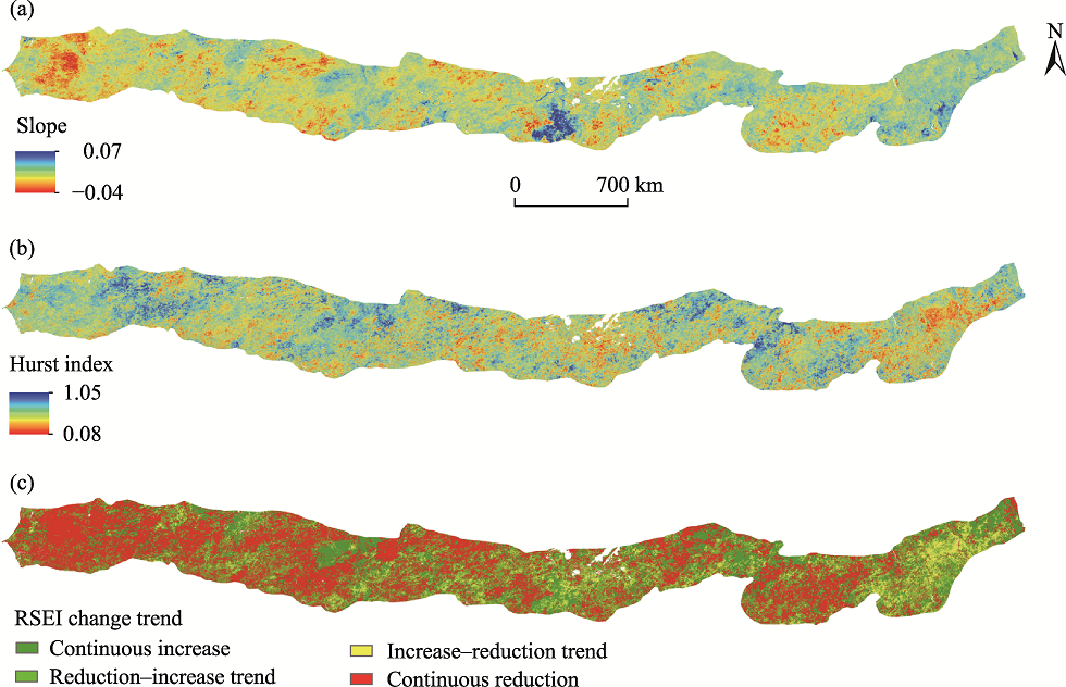
Abstract Long-term monitoring of the ecological environment changes is helpful for the protection of the ecological environment. Based on the ecological environment of the Sahel region in Africa, we established a remote sensing ecological index (RSEI) model for this region by combining dryness, moisture, greenness, and desertification indicators. Using the Moderate-resolution Imaging Spectroradiometer (MODIS) data in Google Earth Engine (GEE) platform, this study analyzed the ecological environment quality of the Sahel region during the period of 2001-2020. We used liner regression and fluctuation analysis methods to study the trend and fluctuation of RSEI, and utilized the stepwise regression approach to analyze the contribution of each indicator to the RSEI. Further, the correlation analysis was used to analyze the correlation between RSEI and precipitation, and Hurst index was applied to evaluate the change trend of RSEI in the future. The results show that RSEI of the Sahel region exhibited spatial heterogeneity. Specifically, it exhibited a decrease in gradient from south to north of the Sahel region. Moreover, RSEI in parts of the Sahel region presented non-zonal features. Different land-cover types demonstrated different RSEI values and changing trends. We found that RSEI and precipitation were positively correlated, suggesting that precipitation is the controlling factor of RSEI. The areas where RSEI values presented an increasing trend were slightly less than the areas where RSEI values presented a decreasing trend. In the Sahel region, the areas with the ecological environment characterized by continuous deterioration and continuous improvement accounted for 44.02% and 28.29% of the total study area, respectively, and the areas in which the ecological environment was changing from improvement to deterioration and from deterioration to improvement accounted for 12.42% and 15.26% of the whole area, respectively. In the face of the current ecological environment and future change trends of RSEI in the Sahel region, the research results provide a reference for the construction of the ''Green Great Wall'' (GGW) ecological environment project in Africa.
|
|
Received: 16 April 2021
Published: 31 January 2022
|
|
Corresponding Authors:
* GAO Xin (E-mail: gaoxin@ms.xjb.ac.cn)
|
|
|
| [1] |
Abiodun B J, Salami A T, Matthew O J, et al. 2013. Potential impacts of afforestation on climate change and extreme events in Nigeria. Climate Dynamics, 41(2):277-293.
doi: 10.1007/s00382-012-1523-9
|
|
|
| [2] |
Ackerman S A, Strabala K I, Menzel W P, et al. 1998. Discriminating clear sky from clouds with MODIS. Journal of Geophysical Research Atmospheres, 103(24):32141-32157.
doi: 10.1029/1998JD200032
|
|
|
| [3] |
Adams M D, DeLuca P F, Corr D, et al. 2012. Mobile air monitoring: measuring change in air quality in the city of Hamilton, 2005-2010. Social Indicators Research, 108(2):351-364.
doi: 10.1007/s11205-012-0061-5
|
|
|
| [4] |
Bashir B, Cao C X, Naeem S, et al. 2020. Spatio-temporal vegetation dynamic and persistence under climatic and anthropogenic factors. Remote Sensing, 12(16):2612.
doi: 10.3390/rs12162612
|
|
|
| [5] |
Birth G S. 1985. Evaluation of correlation coefficients obtained with a stepwise regression analysis. Applied Spectroscopy, 39(4):729-732.
doi: 10.1366/0003702854250031
|
|
|
| [6] |
Biswal S S, Gorai A K. 2020. Change detection analysis in coverage area of coal fire from 2009 to 2019 in Jharia coalfield using remote sensing data. International Journal of Remote Sensing, 41(24):9545-9564.
doi: 10.1080/01431161.2020.1800128
|
|
|
| [7] |
Carlson T N, Ripley D A. 1997. On the relation between NDVI, fractional vegetation cover, and leaf area index. Remote Sensing of Environment, 62(3):241-252.
doi: 10.1016/S0034-4257(97)00104-1
|
|
|
| [8] |
Dai A G. 2011. Drought under global warming: a review. Wiley Interdisciplinary Reviews: Climate Change, 2(1):45-65.
doi: 10.1002/wcc.v2.1
|
|
|
| [9] |
Dardel C, Kergoat L, Hiernaux P, et al. 2014. Re-greening Sahel: 30 years of remote sensing data and field observations (Mali, Niger). Remote Sensing of Environment, 140:350-364.
doi: 10.1016/j.rse.2013.09.011
|
|
|
| [10] |
Diedhiou A, Bichet A, Wartenburger R, et al. 2018. Changes in climate extremes over west and central Africa at 1.5°C and 2°C global warming. Environmental Research Letters, 13(6):065020, doi: 0000-0003-4470-5080.
doi: 0000-0003-4470-5080
|
|
|
| [11] |
Ebrahimi A, Asadi E, Ebrahimi A,, et al. 2020. Prediction of future grassland vegetation cover fluctuation under climate change scenarios. Ecological Indicators, 116:106858, doi: 10.1016/j.ecolind.2020.106858.
doi: 10.1016/j.ecolind.2020.106858
|
|
|
| [12] |
Epule E T, Peng C H, Lepage L, et al. 2014. The causes, effects and challenges of Sahelian droughts: a critical review. Regional Environmental Change, 14(1):145-156.
doi: 10.1007/s10113-013-0473-z
|
|
|
| [13] |
Estel S, Kuemmerle T, Alcantara C, et al. 2015. Mapping farmland abandonment and recultivation across Europe using MODIS NDVI time series. Remote Sensing of Environment, 163:312-325.
doi: 10.1016/j.rse.2015.03.028
|
|
|
| [14] |
Fan C, Gui F, Wang L Z, et al. 2020. Evaluation of environmental quality based on remote sensing data in the coastal lands of eastern China. Journal of Coastal Research, 36(6):1229-1236.
|
|
|
| [15] |
FAO. 2010. Food and Agriculture Organization of the United Nations. Retrieved, 3(13):2012.
|
|
|
| [16] |
Fensholt R, Langanke T, Rasmussen K, et al. 2012. Greenness in semi-arid areas across the globe 1981-2007—an earth observing satellite based analysis of trends and drivers. Remote Sensing of Environment, 121:144-158.
doi: 10.1016/j.rse.2012.01.017
|
|
|
| [17] |
Fensholt R, Rasmussen K, Kaspersen P, et al. 2013. Assessing land degradation/recovery in the African Sahel from long-term Earth observation based primary productivity and precipitation relationships. Remote Sensing, 5(2):664-686.
doi: 10.3390/rs5020664
|
|
|
| [18] |
Firth L B, Schofield M, White F J, et al. 2014. Biodiversity in intertidal rock pools: Informing engineering criteria for artificial habitat enhancement in the built environment. Marine Environmental Research, 102:122-130.
doi: 10.1016/j.marenvres.2014.03.016
|
|
|
| [19] |
Foley J A, Coe M T, Scheffer M, et al. 2003. Regime shifts in the Sahara and Sahel: interactions between ecological and climatic systems in northern Africa. Ecosystems, 6(6):524-539.
doi: 10.1007/s10021-002-0227-0
|
|
|
| [20] |
Gao P W, Kasimu A, Zhao Y Y, et al. 2020. Evaluation of the temporal and spatial changes of ecological quality in the Hami Oasis based on RSEI. Sustainability, 12(18):7716, doi: 10.3390/su12187716.
doi: 10.3390/su12187716
|
|
|
| [21] |
Giannini A, Biasutti M, Verstraete M. 2008. A climate model-based review of drought in the Sahel: Desertification, the re-greening and climate change. Global and Planetary Change, 64(3-4):119-128.
doi: 10.1016/j.gloplacha.2008.05.004
|
|
|
| [22] |
Goffner D, Sinare H, Gordon L J. 2019. The Great Green Wall for the Sahara and the Sahel initiative as an opportunity to enhance resilience in Sahelian landscapes and livelihoods. Regional Environmental Change, 19(5):1417-1428.
doi: 10.1007/s10113-019-01481-z
|
|
|
| [23] |
Gou R, Zhao J. 2020. Eco-environmental quality monitoring in Beijing, China, using an RSEI-based approach combined with random forest algorithms. IEEE Access, 8:196657-196666.
doi: 10.1109/Access.6287639
|
|
|
| [24] |
Gu J, Grybas H, Congalton R G. 2020. Individual tree crown delineation from UAS imagery based on region growing and growth space considerations. Remote Sensing, 12(15):2363, doi: 10.3390/rs12152363.
doi: 10.3390/rs12152363
|
|
|
| [25] |
Gu X H, Zhang Q, Li J F, et al. 2019. Intensification and expansion of soil moisture drying in warm season over Eurasia under global warming. Journal of Geophysical Research: Atmospheres, 124:3765-3782.
doi: 10.1029/2018JD029776
|
|
|
| [26] |
Hang X, Li Y C, Luo X C, et al. 2020. Assessing the ecological quality of Nanjing during its urbanization process by using satellite, meteorological, and socioeconomic data. Journal of Meteorological Research, 34(2):280-293.
doi: 10.1007/s13351-020-9150-6
|
|
|
| [27] |
Held I M, Delworth T L, Lu J, et al. 2005. Simulation of Sahel drought in the 20th and 21st centuries. Proceedings of the National Academy of Sciences, 102(50):17891-17896.
|
|
|
| [28] |
Huber S, Fensholt R, Rasmussen K. 2011. Water availability as the driver of vegetation dynamics in the African Sahel from 1982 to 2007. Global and Planetary Change, 76(3-4):186-195.
doi: 10.1016/j.gloplacha.2011.01.006
|
|
|
| [29] |
IPCC. 2014. Mitigation of Climate Change. Working Group III Contribution to the Fifth Assessment Report of the Intergovernmental Panel on Climate Change. In: Edenhofer O, Pichs-Madruga R, Sokona Y, et al. Cambridge and New York: Cambridge University Press, 151-207.
|
|
|
| [30] |
Issa O, Jürgen R, Joachim E, et al. 2014. The re-greening of the Sahel: natural cyclicity or human-induced change? Land, 3(3):1075-1090.
doi: 10.3390/land3031075
|
|
|
| [31] |
Ji J W, Wang S X, Zhou Y, et al. 2020. Spatiotemporal change and landscape pattern variation of eco-environmental quality in Jing-Jin-Ji urban agglomeration from 2001 to 2015. IEEE Access, 8:125534-125548.
doi: 10.1109/Access.6287639
|
|
|
| [32] |
Jing Y Q, Zhang F, He Y F, et al. 2020. Assessment of spatial and temporal variation of ecological environment quality in Ebinur lake wetland national nature reserve, Xinjiang, China. Ecological Indicators, 110:105874, doi: 10.1016/j.ecolind.2019.105874.
doi: 10.1016/j.ecolind.2019.105874
|
|
|
| [33] |
Jolliffe I T, Cadima J. 2016. Principal component analysis: a review and recent developments. Philosophical Transactions of the Royal Society A: Mathematical Physical and Engineering Sciences, 374(2065):20150202, doi: 10.1098/rsta.2015.0202.
doi: 10.1098/rsta.2015.0202
|
|
|
| [34] |
Kesteven G L. 1946. The coefficient of variation. Nature, 158(4015):520-521.
|
|
|
| [35] |
Knauer K, Gessner U, Fensholt R, et al. 2017. Monitoring agricultural expansion in Burkina Faso over 14 years with 30 m resolution time series: The role of population growth and implications for the environment. Remote Sensing, 9(2):132, doi: 10.3390/rs9020132.
doi: 10.3390/rs9020132
|
|
|
| [36] |
Kusserow H. 2017. Desertification, resilience, and re-greening in the African Sahel -a matter of the observation period? Earth System Dynamics Discussions, 8(4):1141-1170.
|
|
|
| [37] |
Le H, Henri N. 1989. The grazing land ecosystems of the African Sahel. Springer Berlin Heidelberg, 44(6), doi: 10.1007/978-3-642-74457-0.
doi: 10.1007/978-3-642-74457-0
|
|
|
| [38] |
Leblanc M, Lemoalle J, Bader J C, et al. 2011. Thermal remote sensing of water under flooded vegetation: New observations of inundation patterns for the 'small' lake Chad. Journal of Hydrology, 404(1-2):87-98.
doi: 10.1016/j.jhydrol.2011.04.023
|
|
|
| [39] |
Lee E, He Y Q, Zhou M, et al. 2015. Potential feedback of recent vegetation changes on summer rainfall in the Sahel. Physical Geography, 36(6):449-470.
doi: 10.1080/02723646.2015.1120139
|
|
|
| [40] |
Leroux L, Bégué A, Lo S D, et al. 2017. Driving forces of recent vegetation changes in the Sahel: Lessons learned from regional and local level analyses. Remote Sensing of Environment, 191:38-54.
doi: 10.1016/j.rse.2017.01.014
|
|
|
| [41] |
Liao W H, Jiang W G. 2020. Evaluation of the spatiotemporal variations in the eco-environmental quality in China based on the remote sensing ecological index. Remote Sensing, 12(15):2462, doi: 10.3390/rs12152462.
doi: 10.3390/rs12152462
|
|
|
| [42] |
Liu Q, Yang Z P, Han F, et al. 2019. Ecological environment assessment in world natural heritage site based on remote-sensing data. A case study from the Bayinbuluke. Sustainability, 11(22):6385, doi: 10.3390/su11226385.
doi: 10.3390/su11226385
|
|
|
| [43] |
Liu S L, Cheng F Y, Dong S K, et al. 2017. Spatiotemporal dynamics of grassland aboveground biomass on the Qinghai-Tibet Plateau based on validated MODIS NDVI. Scientific Reports, 7(1):1-10.
doi: 10.1038/s41598-016-0028-x
|
|
|
| [44] |
Lobser S E, Cohen W B. 2007. MODIS tasselled cap: land cover characteristics expressed through transformed MODIS data. International Journal of Remote Sensing, 28(22):5079-5101.
doi: 10.1080/01431160701253303
|
|
|
| [45] |
Ma Z Y, Xie Y W, Jiao J Z, et al. 2011. The construction and application of an Aledo-NDVI based desertification monitoring model. Procedia Environmental Sciences, 10:2029-2035.
doi: 10.1016/j.proenv.2011.09.318
|
|
|
| [46] |
Mainali K P. 2006. Grazing causes desertification in Sahel. Frontiers in Ecology and the Environment, 4(5):232, doi: 10.2307/3868780.
doi: 10.2307/3868780
|
|
|
| [47] |
Mark Z. 2019. China's tree-planting drive could falter in a warming world. Nature, 573(7775):474-475.
doi: 10.1038/d41586-019-02789-w
|
|
|
| [48] |
Miao C L, Sun L Y, Yang L. 2016. The studies of ecological environmental quality assessment in Anhui Province based on ecological footprint. Ecological Indicators, 60:879-883.
doi: 10.1016/j.ecolind.2015.08.040
|
|
|
| [49] |
Monerie P A, Sanchez G E, Gaetani M, et al. 2020. Future evolution of the Sahel precipitation zonal contrast in CESM1. Climate Dynamics, 55(9):2801-2821.
doi: 10.1007/s00382-020-05417-w
|
|
|
| [50] |
Moser L, Voigt S, Schoepfer E, et al. 2014. Multitemporal wetland monitoring in Sub-Saharan West-Africa using medium resolution optical satellite data. IEEE Journal of Selected Topics in Applied Earth Observations and Remote Sensing, 7(8):3402-3415.
doi: 10.1109/JSTARS.4609443
|
|
|
| [51] |
Moss R H, Edmonds J A, Hibbard K A, et al. 2010. The next generation of scenarios for climate change research and assessment. Nature, 463(7282):747-756.
doi: 10.1038/nature08823
|
|
|
| [52] |
Mutti P R, Lucio P S, Dubreuil V, et al. 2020. NDVI time series stochastic models for the forecast of vegetation dynamics over desertification hotspots. International Journal of Remote Sensing, 41:2759-2788.
doi: 10.1080/01431161.2019.1697008
|
|
|
| [53] |
Ning L, Wang J Y, Fen Q. 2020. The improvement of ecological environment index model RSEI. Arabian Journal of Geosciences, 13:1-14.
doi: 10.1007/s12517-019-5007-7
|
|
|
| [54] |
Pope P T. 1970. Thoughts on stepwise regression analysis. Industrial and Engineering Chemistry, 62(7):35-36.
|
|
|
| [55] |
Qureshi S, Alavipanah S K, Konyushkova M, et al. 2020. A remotely sensed assessment of surface ecological change over the Gomishan Wetland, Iran. Remote Sensing, 12(18):2989, doi: 10.3390/rs12182989.
doi: 10.3390/rs12182989
|
|
|
| [56] |
Rey S J, Stephens P, Laura J. 2017. An evaluation of sampling and full enumeration strategies for Fisher Jenks classification in big data settings. Transactions in GIS, 21(4):796-810.
doi: 10.1111/tgis.2017.21.issue-4
|
|
|
| [57] |
Rikimaru A, Roy P S, Miyatake S. 2002. Tropical forest cover density mapping. Tropical Ecology, 43(1):39-47.
|
|
|
| [58] |
Scheffer M, Carpenter S, Foley J A, et al. 2001. Catastrophic shifts in ecosystems. Nature, 413(6856):591-596.
doi: 10.1038/35098000
|
|
|
| [59] |
Shao Z F, Ding L, Li D R, et al. 2020. Exploring the relationship between urbanization and ecological environment using remote sensing images and statistical data: A case study in the Yangtze River Delta, China. Sustainability, 12(14):5620.
doi: 10.3390/su12145620
|
|
|
| [60] |
Sih A, Ferrari M C O, Harris D J. 2011. Evolution and behavioural responses to human-induced rapid environmental change. Evolutionary Applications, 4(2):367-387.
doi: 10.1111/j.1752-4571.2010.00166.x
|
|
|
| [61] |
Singh R B, Kumar A, Kumar R, et al. 2014. Ecosystem Services in Changing Environment. Tokyo: Springer, 139-153.
|
|
|
| [62] |
Thakur J K, Srivastava P K, Singh S K, et al. 2012. Ecological monitoring of wetlands in semi-arid region of Konya closed Basin, Turkey. Regional Environmental Change, 12(1):133-144.
doi: 10.1007/s10113-011-0241-x
|
|
|
| [63] |
Tong S Q, Zhang J Q, Bao Y H, et al. 2018. Analyzing vegetation dynamic trend on the Mongolian Plateau based on the Hurst exponent and influencing factors from 1982-2013. Journal of Geographical Sciences, 28(5):595-610.
doi: 10.1007/s11442-018-1493-x
|
|
|
| [64] |
Toure A A, Tidjani A D, Rajot J L, et al. 2019. Dynamics of wind erosion and impact of vegetation cover and land use in the Sahel: A case study on sandy dunes in Southeastern Niger. CATENA, 177:272-285.
doi: 10.1016/j.catena.2019.02.011
|
|
|
| [65] |
Tucker C J, Vanpraet C L, Sharman M J, et al. 1985. Satellite remote sensing of total herbaceous biomass production in the Senegalese Sahel: 1980-1984. Remote Sensing of Environment, 17(3):233-249.
doi: 10.1016/0034-4257(85)90097-5
|
|
|
| [66] |
van keulen H, Breman H. 1990. Agricultural development in the West African Sahelian region: a cure against land hunger? Agriculture, Ecosystems & Environment, 32(3-4):177-197.
|
|
|
| [67] |
Vitousek P M. 1994. Beyond global warming: ecology and global change. Ecology, 75(7):1861-1876.
doi: 10.2307/1941591
|
|
|
| [68] |
Wade T I, Ndiaye O, Mauclaire M, et al. 2018. Biodiversity field trials to inform reforestation and natural resource management strategies along the African Great Green Wall in Senegal. New Forests, 49(3):341-362.
doi: 10.1007/s11056-017-9623-3
|
|
|
| [69] |
Walther G R, Post E, Convey P, et al. 2002. Ecological responses to recent climate change. Nature, 416(6879):389-395.
doi: 10.1038/416389a
|
|
|
| [70] |
Wang S D, Si J J, Wang Y. 2021. Study on evaluation of ecological environment quality and temporal-spatial evolution of Danjiang River Basin (Henan Section). Polish Journal of Environmental Studies, 30(3):2353-2367.
doi: 10.15244/pjoes/128110
|
|
|
| [71] |
Wen X L, Ming Y L, Gao Y G, et al. 2020. Dynamic monitoring and analysis of ecological quality of Pingtan comprehensive experimental zone, a new type of sea island city, based on RSEI. Sustainability, 12(1):21, doi: 10.3390/su12010021.
doi: 10.3390/su12010021
|
|
|
| [72] |
Wu S P, Gao X, Lei J Q, et al. 2020. Spatial and temporal changes in the normalized difference vegetation index and their driving factors in the desert/grassland biome transition zone of the Sahel region of Africa. Remote Sensing, 12(24):4119, doi: 10.3390/rs12244119.
doi: 10.3390/rs12244119
|
|
|
| [73] |
Xiong Y, Xu W H, Huang S D, et al. 2020. Ecological environment quality assessment of Xishuangbanna rubber plantations expansion (1995-2018) based on Multi-temporal Landsat imagery and RSEI. Geocarto International, doi: 10.1080/10106049.2020.1861663.
doi: 10.1080/10106049.2020.1861663
|
|
|
| [74] |
Xu H Q. 2008. A new index for delineating built-up land features in satellite imagery. International Journal of Remote Sensing, 29(14):4269-4276.
doi: 10.1080/01431160802039957
|
|
|
| [75] |
Xu H Q. 2013. A remote sensing urban ecological index and its application. Acta Ecologica Sinica, 33(24):7853-7862. (in Chinese)
|
|
|
| [76] |
Xu H Q, Wang Y F, Guan H D, et al. 2019. Detecting ecological changes with a remote sensing based ecological index (RSEI) produced time series and change vector analysis. Remote Sensing, 11(20):2345, doi: 10.3390/rs11202345.
doi: 10.3390/rs11202345
|
|
|
| [77] |
Xu L, Zheng C L, Ma Y. 2021. Variations in precipitation extremes in the arid and semi-arid regions of China. International Journal of Climatology, 41(3):1542-1554.
doi: 10.1002/joc.v41.3
|
|
|
| [78] |
Yim S H L. 2020. Development of a 3D real-time atmospheric monitoring system (3DREAMS) using doppler LiDARs and applications for long-term analysis and hot-and-polluted episodes. Remote Sensing, 12(6):1036, doi: 10.3390/rs12061036.
doi: 10.3390/rs12061036
|
|
|
| [79] |
You Y, Ren H J, Zhou N, et al. 2019. The Pan-African Great Green Wall Initiative and its development of agriculture, animal husbandry & forestry. World Forestry Research, 32(5):85-90.
|
|
|
| [80] |
Zhang X, Wang H, Che H Z, et al. 2020. Improvement of snow/haze confusion data gaps in MODIS dark target aerosol retrievals in east China. Atmospheric Research, 245:105063, doi: 10.1016/j.atmosres.2020.105063.
doi: 10.1016/j.atmosres.2020.105063
|
|
|
| [81] |
Zheng Z, Wu Z, Chen Y, et al. 2020. Exploration of eco-environment and urbanization changes in coastal zones: A case study in China over the past 20 years. Ecological Indicators, 119:106847, doi: 10.1016/j.ecolind.2020.106847.
doi: 10.1016/j.ecolind.2020.106847
|
|
|
| [82] |
Zhou G Y, Xia J, Zhou P, et al. 2020. Not vegetation itself but mis-revegetation reduces water resources. Science China Earth Science, 64(3):404-411.
doi: 10.1007/s11430-020-9670-x
|
|
|
| [83] |
Zhou H R. 2000. Study on ecological environmental quality as assessment index system of Xinjiang. China Environmental Science, 20(2):150-153. (in Chinese)
|
|
|
| [84] |
Zika M, Erb K H. 2017. The global loss of net primary production resulting from human-induced soil degradation in drylands. Ecological Economics, 69(2):310-318.
doi: 10.1016/j.ecolecon.2009.06.014
|
|
|
| [85] |
Zoffoli M L, Kandus P, Madanes N, et al. 2008. Seasonal and interannual analysis of wetlands in South America using NOAA-AVHRR NDVI time series: the case of the Parana Delta Region. Landscape Ecology, 23(7):833-848.
doi: 10.1007/s10980-008-9240-9
|
|
|
|
Viewed |
|
|
|
Full text
|
|
|
|
|
Abstract
|
|
|
|
|
Cited |
|
|
|
|
| |
Shared |
|
|
|
|
| |
Discussed |
|
|
|
|