| Research article |
|


|
|
|
| Efficient soil moisture estimation on the Qinghai- Xizang Plateau via machine learning and optimized feature selection |
JIA Shichao1,2, SUN Wen3,*( ), WEI Sihao4, SUN Rui1 ), WEI Sihao4, SUN Rui1 |
1School of Geomatics, Anhui University of Science and Technology, Huainan 232001, China
2Institute of Land Surveying and Spatial Geographic Information, Anhui University of Science and Technology, Huainan 232001, China
3Institute of Tibetan Plateau Research, Chinese Academy of Sciences, Beijing 100101, China
4School of Atmospheric Sciences, Sun Yat-sen University, and Key Laboratory of Tropical Atmosphere-Ocean System, Ministry of Education, Zhuhai 519082, China |
|
|
|
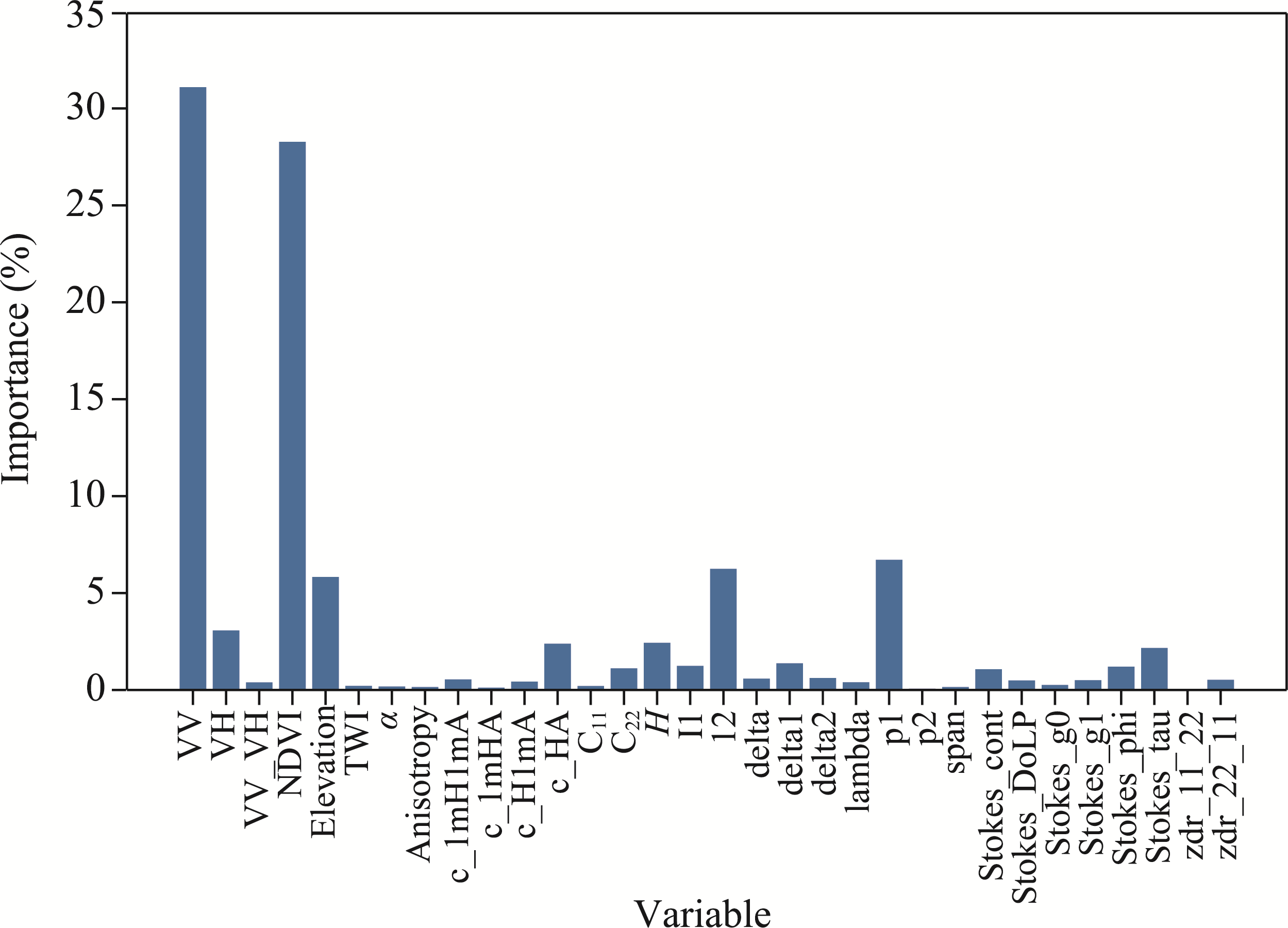
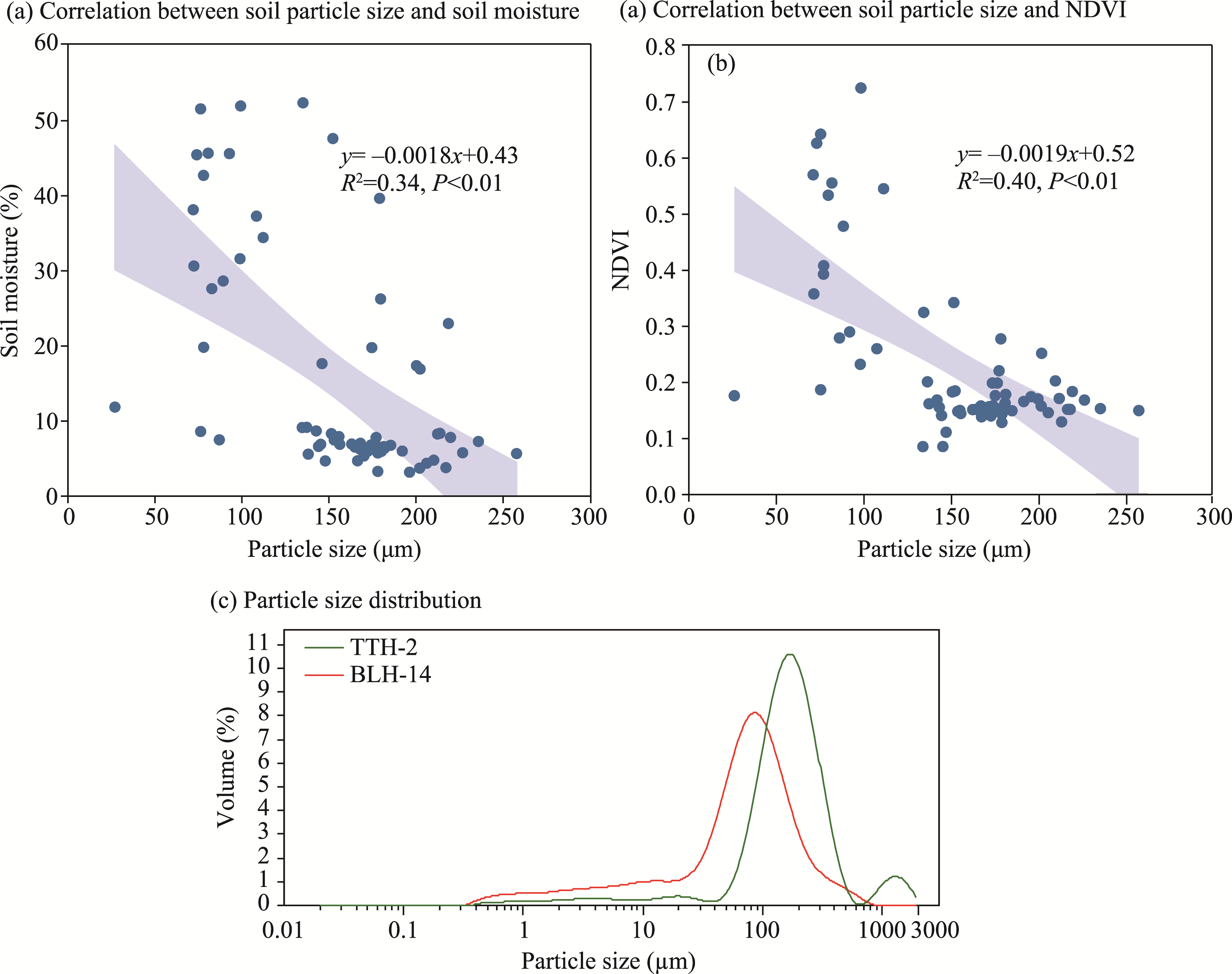
Abstract Soil moisture is a key parameter in the exchange of energy and water between the land surface and the atmosphere. This parameter plays an important role in the dynamics of permafrost on the Qinghai-Xizang Plateau, China, as well as in the related ecological and hydrological processes. However, the region's complex terrain and extreme climatic conditions result in low-accuracy soil moisture estimations using traditional remote sensing techniques. Thus, this study considered parameters of the backscatter coefficient of Sentinel-1A ground range detected (GRD) data, the polarization decomposition parameters of Sentinel-1A single-look complex (SLC) data, the normalized difference vegetation index (NDVI) based on Sentinel-2B data, and the topographic factors based on digital elevation model (DEM) data. By combining these parameters with a machine learning model, we established a feature selection rule. A cumulative importance threshold was derived for feature variables, and those variables that failed to meet the threshold were eliminated based on variations in the coefficient of determination (R2) and the unbiased root mean square error (ubRMSE). The eight most influential variables were selected and combined with the CatBoost model for soil moisture inversion, and the SHapley Additive exPlanations (SHAP) method was used to analyze the importance of these variables. The results demonstrated that the optimized model significantly improved the accuracy of soil moisture inversion. Compared to the unfiltered model, the optimal feature combination led to a 0.09 increase in R2 and a 0.7% reduction in ubRMSE. Ultimately, the optimized model achieved a R² of 0.87 and an ubRMSE of 5.6%. Analysis revealed that soil particle size had significant impact on soil water retention capacity. The impact of vegetation on the estimated soil moisture on the Qinghai-Xizang Plateau was considerable, demonstrating a significant positive correlation. Moreover, the microtopographical features of hummocks interfered with soil moisture estimation, indicating that such terrain effects warrant increased attention in future studies within the permafrost regions. The developed method not only enhances the accuracy of soil moisture retrieval in the complex terrain of the Qinghai-Xizang Plateau, but also exhibits high computational efficiency (with a relative time reduction of 18.5%), striking an excellent balance between accuracy and efficiency. This approach provides a robust framework for efficient soil moisture monitoring in remote areas with limited ground data, offering critical insights for ecological conservation, water resource management, and climate change adaptation on the Qinghai-Xizang Plateau.
|
|
Received: 17 December 2024
Published: 31 August 2025
|
|
Corresponding Authors:
*SUN Wen (E-mail: wensun@itpcas.ac.cn)
|
|
|
| [1] |
Acar E, Özerdem M S. 2020. On a yearly basis prediction of soil water content utilizing SAR data: a machine learning and feature selection approach. Turkish Journal of Electrical Engineering and Computer Sciences, 28(4): 2316-2330.
|
|
|
| [2] |
Ahmad S, Kalra A, Stephen H. 2010. Estimating soil moisture using remote sensing data: A machine learning approach. Advances in Water Resources, 33(1): 69-80.
|
|
|
| [3] |
Arora V. 2002. Modeling vegetation as a dynamic component in soil-vegetation-atmosphere transfer schemes and hydrological models. Reviews of Geophysics, 40(2): 3-1-3-26.
|
|
|
| [4] |
Ayehu G, Tadesse T, Gessesse B, et al. 2020. Combined use of Sentinel-1 SAR and Landsat sensors products for residual soil moisture retrieval over agricultural fields in the Upper Blue Nile basin, Ethiopia. Sensors, 20(11): 3282, doi: 10.3390/s20113282.
|
|
|
| [5] |
Baghdadi N, Dubois-Fernandez P, Dupuis X, et al. 2012. Sensitivity of main polarimetric parameters of multifrequency polarimetric SAR data to soil moisture and surface roughness over bare agricultural soils. IEEE Geoscience and Remote Sensing Letters, 10(4): 731-735.
|
|
|
| [6] |
Banerjee K S, Carr R N. 1971. A comment on Ridge Regression. Biased estimation for non-orthogonal problems. Technometrics, 13(4): 895-898.
|
|
|
| [7] |
Biau G. 2012. Analysis of a random forests model. The Journal of Machine Learning Research, 13(1): 1063-1095.
|
|
|
| [8] |
Bourgeau-Chavez L L, Leblon B, Charbonneau F, et al. 2013. Evaluation of polarimetric Radarsat-2 SAR data for development of soil moisture retrieval algorithms over a chronosequence of black spruce boreal forests. Remote Sensing of Environment, 132: 71-85.
|
|
|
| [9] |
Breiman L, Friedman J, Olshen R, et al. 1984. Classification and regression trees. Belmont, CA: Wadsworth International Group, 37(15): 237-251.
|
|
|
| [10] |
Breiman L. 2001. Random forests. Machine Learning, 45: 5-32.
|
|
|
| [11] |
Brekke C, Anfinsen S N. 2010. Ship detection in ice-infested waters based on dual-polarization SAR imagery. IEEE Geoscience and Remote Sensing Letters, 8(3): 391-395.
|
|
|
| [12] |
Cao B, Gruber S, Zhang T J, et al. 2017a. Spatial variability of active layer thickness detected by ground-penetrating radar in the Qilian Mountains, western China. Journal of Geophysical Research: Earth Surface, 122(3): 574-591.
|
|
|
| [13] |
Cao B, Quan X J, Brown N, et al. 2019a. GlobSim (v1.0): deriving meteorological time series for point locations from multiple global reanalyses. Geoscientific Model Development, 12(11): 4661-4679.
|
|
|
| [14] |
Cao B, Zhang T J, Wu Q B, et al. 2019b. Permafrost zonation index map and statistics over the Qinghai-Tibet Plateau based on field evidence. Permafrost and Periglacial Processes, 30(3): 178-194.
|
|
|
| [15] |
Cao B, Gruber S, Zheng D H, et al. 2020. The ERA5-Land soil temperature bias in permafrost regions. The Cryosphere, 14(8): 2581-2595.
|
|
|
| [16] |
Cao W, Sheng Y, Wu J C, et al. 2017b. Spatial variability and its main controlling factors of the permafrost soil-moisture on the northern-slope of Bayan Har Mountains in Qinghai-Tibet Plateau. Journal of Mountain Science, 14(12): 2406-2419.
|
|
|
| [17] |
Chen Y Y, Yang K, Qin J, et al. 2017. Evaluation of SMAP, SMOS, and AMSR2 soil moisture retrievals against observations from two networks on the Tibetan Plateau. Journal of Geophysical Research: Atmospheres, 122(11): 5780-5792.
|
|
|
| [18] |
Cloude S R, Pottier E. 1997. An entropy based classification scheme for land applications of polarimetric SAR. IEEE transactions on geoscience and remote sensing, 35(1): 68-78.
|
|
|
| [19] |
Cortes C, Vapnik V. 1995. Support-vector networks. Machine Learning, 20(3): 273-297.
|
|
|
| [20] |
Cover T, Hart P. 1967. Nearest neighbor pattern classification. IEEE Transactions on Information Theory, 13(1): 21-27.
|
|
|
| [21] |
Dente L, Vekerdy Z, Wen J, et al. 2012. Maqu network for validation of satellite-derived soil moisture products. International Journal of Applied Earth Observation and Geoinformation, 17: 55-65.
|
|
|
| [22] |
Dramsch J S. 2020. 70 years of machine learning in geoscience in review. Advances in geophysics, 61: 1-55.
|
|
|
| [23] |
Drucker H, Burges C J, Kaufman L, et al. 1997. Support vector regression machines. Advances in Neural Information Processing Systems, 9: 155-161.
|
|
|
| [24] |
Feng W, Lu H W, Yao T C, et al. 2020. Drought characteristics and its elevation dependence in the Qinghai-Tibet plateau during the last half-century. Scientific Reports, 10(1): 14323, doi: 10.1038/s41598-020-71295-1.
pmid: 32868800
|
|
|
| [25] |
Freitas A A. 2014. Comprehensible classification models: a position paper. ACM SIGKDD Explorations Newsletter, 15(1): 1-10.
|
|
|
| [26] |
Gao T G, Zhang T J, Wan X D, et al. 2016. Influence of microtopography on active layer thaw depths in Qilian Mountain, northeastern Tibetan Plateau. Environmental Earth Sciences, 75: 1-12.
|
|
|
| [27] |
Guyon I, Elisseeff A. 2003. An introduction to variable and feature selection. Journal of Machine Learning Research, 3: 1157-1182.
|
|
|
| [28] |
Günther M, Kasirzadeh A. 2022. Algorithmic and human decision making: for a double standard of transparency. AI & SOCIETY, 37(1): 375-381.
|
|
|
| [29] |
He L, Cheng Y, Li Y X, et al. 2021. An improved method for soil moisture monitoring with ensemble learning methods over the Tibetan plateau. IEEE Journal of Selected Topics in Applied Earth Observations and Remote Sensing, 14: 2833-2844.
|
|
|
| [30] |
Huang Z T, Petrovic A M. 1994. Physical properties of sand as affected by clinoptilolite zeolite particle size and quantity. Journal of Turfgrass Management, 1(1): 1-15.
|
|
|
| [31] |
Ibrahim H M, Alghamdi A G. 2021. Effect of the particle size of clinoptilolite zeolite on water content and soil water storage in a loamy sand soil. Water, 13(5): 607, doi: 10.3390/w13050607.
|
|
|
| [32] |
Jia S C, Zhang T J, Hao J S, et al. 2022. Spatial variability of active layer thickness along the Qinghai-Tibet Engineering Corridor resolved using ground-penetrating Radar. Remote Sensing, 14(21): 5606, doi: 10.3390/rs14215606.
|
|
|
| [33] |
Kopecký M, Macek M, Wild J. 2021. Topographic Wetness Index calculation guidelines based on measured soil moisture and plant species composition. Science of the Total Environment, 757: 143785, doi: 10.1016/j.scitotenv.2020.143785.
|
|
|
| [34] |
Kornelsen K C, Coulibaly P. 2013. Advances in soil moisture retrieval from synthetic aperture radar and hydrological applications. Journal of Hydrology, 476: 460-489.
|
|
|
| [35] |
Lee J S, Pottier E. 2017. Polarimetric Radar Imaging:from Basics to Applications. Boca Raton: CRC Press.
|
|
|
| [36] |
Li J C, Chen W W, Liu Z P. 2018. The Qinghai-Tibet Railway Geological Environment. In: Geological Line Selection for the Qinghai-Tibet Railway Engineering. Berlin, Heidelberg: Springer, 11-71.
|
|
|
| [37] |
Li Z B, Zhao L, Liu G Y, et al. 2022a. Analysis of soil moisture content in the active layer in the permafrost region of the Tuotuo River source in frozen season. Journal of Glaciology and Geocryology, 44(1): 56-68. (in Chinese)
|
|
|
| [38] |
Li Z B, Zhao L, Wang L X, et al. 2022b. Retrieving soil moisture in the permafrost environment by Sentinel-1/ 2 temporal data on the Qinghai-Tibet Plateau. Remote Sensing, 14(23): 5966, doi: 10.3390/rs14235966.
|
|
|
| [39] |
Li Z L, Leng P, Zhou C H, et al. 2021. Soil moisture retrieval from remote sensing measurements: Current knowledge and directions for the future. Earth-Science Reviews, 218: 103673, doi: 10.1016/j.earscirev.2021.103673.
|
|
|
| [40] |
Liu J, Chai L N, Lu Z, et al. 2019. Evaluation of SMAP, SMOS-IC, FY3B, JAXA, and LPRM soil moisture products over the Qinghai-Tibet Plateau and its surrounding areas. Remote Sensing, 11(7): 792, doi: 10.3390/rs11070792.
|
|
|
| [41] |
Liu L, Schaefer K, Zhang T J, et al. 2012. Estimating 1992-2000 average active layer thickness on the Alaskan North Slope from remotely sensed surface subsidence. Journal of Geophysical Research: Earth Surface, 117(F1): 2011JF002041, doi: 10.1029/2011JF002041.
|
|
|
| [42] |
Liu Y X Y, Yang Y P. 2022. Advances in the quality of global soil moisture products: a review. Remote Sensing, 14(15): 3741, doi: 10.3390/rs14153741.
|
|
|
| [43] |
Lundberg S M, Lee S I. 2017. A unified approach to interpreting model predictions. Proceedings of the 31st International Conference on Neural Information Processing Systems. Long Beach: Curran Associates Inc., 4768-4777.
|
|
|
| [44] |
Luo S, Ren H R, Zhang Y Q. 2023. Estimation of Grassland green biomass using Sentinel-1A SLC image spectral characteristics. Spectroscopy and Spectral Analysis, 43(3): 955-961. (in Chinese)
|
|
|
| [45] |
Ma C F, Li X, McCabe M F. 2020. Retrieval of high-resolution soil moisture through combination of Sentinel-1 and Sentinel-2 data. Remote Sensing, 12(14): 2303, doi: 10.3390/rs12142303.
|
|
|
| [46] |
Ma Y J, Li X Y, Liu L, et al. 2019. Evapotranspiration and its dominant controls along an elevation gradient in the Qinghai Lake watershed, northeast Qinghai-Tibet Plateau. Journal of Hydrology, 575: 257-268.
|
|
|
| [47] |
Ma Y T, Hou P, Zhang L J, et al. 2023. High-resolution quantitative retrieval of soil moisture based on multisource data fusion with random forests: A case study in the Zoige region of the Tibetan Plateau. Remote Sensing, 15(6): 1531, doi: 10.3390/rs15061531.
|
|
|
| [48] |
Mohamed S A, Metwaly M M, Metwalli M R, et al. 2023. Integrating active and passive remote sensing data for mapping soil salinity using machine learning and feature selection approaches in arid regions. Remote Sensing, 15(7): 1751, doi: 10.3390/rs15071751.
|
|
|
| [49] |
Neelam M, Colliander A, Mohanty B P, et al. 2020. Multiscale surface roughness for improved soil moisture estimation. IEEE Transactions on Geoscience and Remote Sensing, 58(8): 5264-5276.
|
|
|
| [50] |
Nguyen T T, Ngo H H, Guo W, et al. 2022. A low-cost approach for soil moisture prediction using multi-sensor data and machine learning algorithm. Science of the Total Environment, 833: 155066, doi: 10.1016/j.scitotenv.2022.155066.
|
|
|
| [51] |
Niu F J, Gao Z Y, Lin Z J, et al. 2019. Vegetation influence on the soil hydrological regime in permafrost regions of the Qinghai-Tibet Plateau, China. Geoderma, 354: 113892, doi: 10.1016/j.geoderma.2019.113892.
|
|
|
| [52] |
Oh Y, Sarabandi K, Ulaby F T. 1992. An empirical model and an inversion technique for radar scattering from bare soil surfaces. IEEE Transactions on Geoscience and Remote Sensing, 30(2): 370-381.
|
|
|
| [53] |
Peng C C, Zeng J Y, Chen K S, et al. 2023. Global spatiotemporal trend of satellite-based soil moisture and its influencing factors in the early 21st century. Remote Sensing of Environment, 291: 113569, doi: 10.1016/j.rse.2023.113569.
|
|
|
| [54] |
Pouyanfar S, Sadiq S, Yan Y L, et al. 2018. A survey on Deep Learning: Algorithms, Techniques, and Applications. ACM Computing Surveys, 51(5): 1-36.
|
|
|
| [55] |
Pradhan S N, Anjum M, Jena P. 2018. Estimation of soil moisture content by remote sensing methods: A review. Journal of Pharmacognosy and Phytochemistry, 7(1S): 1786-1792.
|
|
|
| [56] |
Prokhorenkova L, Gusev G, Vorobev A, et al. 2018. CatBoost: unbiased boosting with categorical features. NIPS'18: Proceedings of the 32nd International Conference on Neural Information Processing Systems. New York: Curran Associates Inc., 6639-6649.
|
|
|
| [57] |
Qu Y Q, Zhu Z L, Montzka C, et al. 2021. Inter-comparison of several soil moisture downscaling methods over the Qinghai-Tibet Plateau, China. Journal of hydrology, 592: 125616, doi: 10.1016/j.jhydrol.2020.125616.
|
|
|
| [58] |
Rani A, Kumar N, Kumar J, et al. 2022. Machine learning for soil moisture assessment. In: Poonia R C, Singh V, Nayak S R. Deep Learning for Sustainable Agriculture. New York: Academic Press, 143-168.
|
|
|
| [59] |
Reading A M, Cracknell M J, Bombardieri D J, et al. 2015. Combining machine learning and geophysical inversion for applied geophysics. ASEG Extended Abstracts, 2015(1): 1-5.
|
|
|
| [60] |
Senanayake I P, Pathira Arachchilage K R L, Yeo I Y, et al. 2024. Spatial downscaling of satellite-based soil moisture products using machine learning techniques: A review. Remote Sensing, 16(12): 2067, doi: 10.3390/rs16122067.
|
|
|
| [61] |
Seneviratne S I, Corti T, Davin E L, et al. 2010. Investigating soil moisture-climate interactions in a changing climate: A review. Earth-Science Reviews, 99(3-4): 125-161.
|
|
|
| [62] |
Singh A, Gaurav K, Sonkar G K, et al. 2023. Strategies to measure soil moisture using traditional methods, automated sensors, remote sensing, and machine learning techniques: review, bibliometric analysis, applications, research findings, and future directions. IEEE Access, 11: 13605-13635.
|
|
|
| [63] |
Srivastava H S, Patel P, Navalgund R R, et al. 2008. Retrieval of surface roughness using multi-polarized Envisat-1 ASAR data. Geocarto International, 23(1): 67-77.
|
|
|
| [64] |
Taghavi-Bayat A, Gerke M, Riedel B. 2024. Soil moisture retrieval at high spatial resolution over alpine ecosystems on Nagqu-Tibetan plateau: A comparative study on semiempirical and machine learning approaches. Science of Remote Sensing, 9: 100135, doi: 10.1016/j.srs.2024.100135.
|
|
|
| [65] |
Tibshirani R. 1996. Regression shrinkage and selection via the lasso. Journal of the Royal Statistical Society: Series B (Methodological), 58(1): 267-288.
|
|
|
| [66] |
Ulaby F T, Moore R K, Fung A K. 1986. Microwave Remote Sensing: Active and Passive, Volume I: Microwave Remote Sensing Fundamentals and Radiometry. Norwood: Artech House Publishers, 1-456.
|
|
|
| [67] |
Veihmeyer F J, Hendrickson A H. 1950. Soil moisture in relation to plant growth. Annual Review of Plant Physiology, 1(1): 285-304.
|
|
|
| [68] |
Wang C, Zhang Z J, Paloscia S, et al. 2018. Permafrost soil moisture monitoring using multi-temporal TerraSAR-X data in Beiluhe of Northern Tibet, China. Remote Sensing, 10(10): 1577, doi: 10.3390/rs10101577.
|
|
|
| [69] |
Wang L X, Wang S G, Ran Y H. 2014. Data sharing and data set application of watershed allied telemetry experimental research. IEEE Geoscience and Remote Sensing Letters, 11(11): 2020-2024.
|
|
|
| [70] |
Wang Z W, Wang Q, Zhao L, et al. 2016. Mapping the vegetation distribution of the permafrost zone on the Qinghai-Tibet Plateau. Journal of Mountain Science, 13: 1035-1046.
|
|
|
| [71] |
Wu G L, Liu Y, Yang Z, et al. 2017. Root channels to indicate the increase in soil matrix water infiltration capacity of arid reclaimed mine soils. Journal of Hydrology, 546: 133-139.
|
|
|
| [72] |
Wu G L, Li X L, Gao J. 2021. The evolution of hummock-depression micro-topography in an alpine marshy wetland in Sanjiangyuan as inferred from vegetation and soil characteristics. Ecology and Evolution, 11(9): 3901-3916.
doi: 10.1002/ece3.7278
pmid: 33976783
|
|
|
| [73] |
Wu W F, Huang X, Shao Z F, et al. 2022. SAR-DRDNet: A SAR image despeckling network with detail recovery. Neurocomputing, 493: 253-267.
|
|
|
| [74] |
Wu Y B, Zhang J, Deng Y C, et al. 2014. Effects of warming on root diameter, distribution, and longevity in an alpine meadow. Plant Ecology, 215: 1057-1066.
|
|
|
| [75] |
Xu L, Abbaszadeh P, Moradkhani H, et al. 2020. Continental drought monitoring using satellite soil moisture, data assimilation and an integrated drought index. Remote Sensing of Environment, 250: 112028, doi: 10.1016/j.rse.2020.112028.
|
|
|
| [76] |
Yao T D, Piao S L, Shen M G, et al. 2017. Chained impacts on modern environment of interaction between Westerlies and Indian Monsoon on Tibetan Plateau. Bulletin of Chinese Academy of Sciences (Chinese Version), 32(9): 976-984. (in Chinese)
|
|
|
| [77] |
Yin G A, Niu F J, Lin Z J, et al. 2017. Effects of local factors and climate on permafrost conditions and distribution in Beiluhe basin, Qinghai-Tibet Plateau, China. Science of the Total Environment, 581-582: 472-485.
|
|
|
| [78] |
Zeng J Y, Li Z, Chen Q, et al. 2015. Evaluation of remotely sensed and reanalysis soil moisture products over the Tibetan Plateau using in-situ observations. Remote Sensing of Environment, 163: 91-110.
|
|
|
| [79] |
Zeng J Y, Shi P F, Chen K S, et al. 2021. Assessment and error analysis of satellite soil moisture products over the third pole. IEEE Transactions on Geoscience and Remote Sensing, 60: 1-18.
|
|
|
| [80] |
Zhang K, Li X, Zheng D H, et al. 2022. Estimation of global irrigation water use by the integration of multiple satellite observations. Water Resources Research, 58(3): e2021WR030031, doi: 10.1029/2021WR030031.
|
|
|
| [81] |
Zhang L, Xue Z H, Liu H, et al. 2023. Enhanced generalized regression neural network with backward sequential feature selection for machine-learning-driven soil moisture estimation: A case study over the Qinghai-Tibet Plateau. IEEE Journal of Selected Topics in Applied Earth Observations and Remote Sensing, 16: 7173-7185.
|
|
|
| [82] |
Zhang T J, Frauenfeld O W, Serreze M C, et al. 2005. Spatial and temporal variability in active layer thickness over the Russian Arctic drainage basin. Journal of Geophysical Research: Atmospheres, 110(D16): 2004JD005642, doi: 10.1029/2004JD005642.
|
|
|
| [83] |
Zhang X F, Zhang H, Wang C, et al. 2021. Soil moisture estimation based on the distributed scatterers adaptive filter over the QTP permafrost region using sentinel-1 and high-resolution TerraSAR-X data. International Journal of Remote Sensing, 42(3): 902-928.
|
|
|
| [84] |
Zhao H F, Li J, Yuan Q Q, et al. 2022. Downscaling of soil moisture products using deep learning: Comparison and analysis on Tibetan Plateau. Journal of Hydrology, 607: 127570, doi: 10.1016/j.jhydrol.2022.127570.
|
|
|
| [85] |
Zhou F J, Yao M M, Fan X W, et al. 2022. Evidence of warming from long-term records of climate and permafrost in the hinterland of the Qinghai-Tibet Plateau. Frontiers in Environmental Science, 10: 836085, doi: 10.3389/fenvs.2022.836085.
|
|
|
| [86] |
Zwieback S, Berg A A. 2019. Fine-scale SAR soil moisture estimation in the subarctic tundra. IEEE Transactions on Geoscience and Remote Sensing, 57(7): 4898-4912.
|
|
|
|
Viewed |
|
|
|
Full text
|
|
|
|
|
Abstract
|
|
|
|
|
Cited |
|
|
|
|
| |
Shared |
|
|
|
|
| |
Discussed |
|
|
|
|