Dynamic spatio-temporal ecological sensitivity evolution in the Hexi region, China
YANG Junhao1, MI Xiaolong1,*(), Joseph AWANGE1, FAN Meiyi2, HUANG Yutong1
1Department of Land Surveying and Geospatial Science, The Hong Kong Polytechnic University, Hong Kong, China 2School of Geographical Sciences, Southwest University, Chongqing 400700, China
The Hexi region is highly vulnerable to ecological degradation, but quantitative assessments of its ecological sensitivity remain limited. This study developed an integrated assessment framework that combines an Albedo-normalized difference vegetation index (NDVI) feature space desertification index with ecological indicators, and analyzed spatio-temporal patterns and drivers of variation in the Hexi region, China during 2003-2020 using analytic hierarchy process (AHP)-entropy weighting and Geographical detector. Ecological sensitivity showed a clear west-east gradient, with highly sensitive areas concentrated in the northern deserts and the southern Qilian Mountains. The average sensitivity increased from 0.4838 in 2003 to 0.5169 in 2020, with a temporary decline to 0.4891 in 2015 due to reduced desertification sensitivity (DS). Habitat sensitivity (HS; q=0.376) and DS (q=0.321) were the dominant drivers, and the interaction between DS and terrain produced the strongest effect (q=0.757). During 2003-2020, barren land decreased by 3.38%, while cropland and grassland increased by 13.76% and 7.21%, respectively. However, rising ecological sensitivity indicates persistent vulnerability despite land-cover improvement. These findings support ecological conservation and sustainable land management in arid regions.
Received: 06 March 2026
Published: 30 September 2026
Conceptualization: YANG Junhao, MI Xiaolong; Methodology: YANG Junhao; Data curation: FAN Meiyi, HUANG Yutong; Formal analysis: YANG Junhao; Writing - original draft preparation: YANG Junhao; Writing - review and editing: YANG Junhao, MI Xiaolong, Joseph AWANGE, FAN Meiyi, HUANG Yutong; Funding acquisition: MI Xiaolong; Supervision: MI Xiaolong, Joseph AWANGE. All authors approved the manuscript.
YANG Junhao, MI Xiaolong, Joseph AWANGE, FAN Meiyi, HUANG Yutong. Dynamic spatio-temporal ecological sensitivity evolution in the Hexi region, China. Journal of Arid Land, 2026, 18(9): 1481-1505.
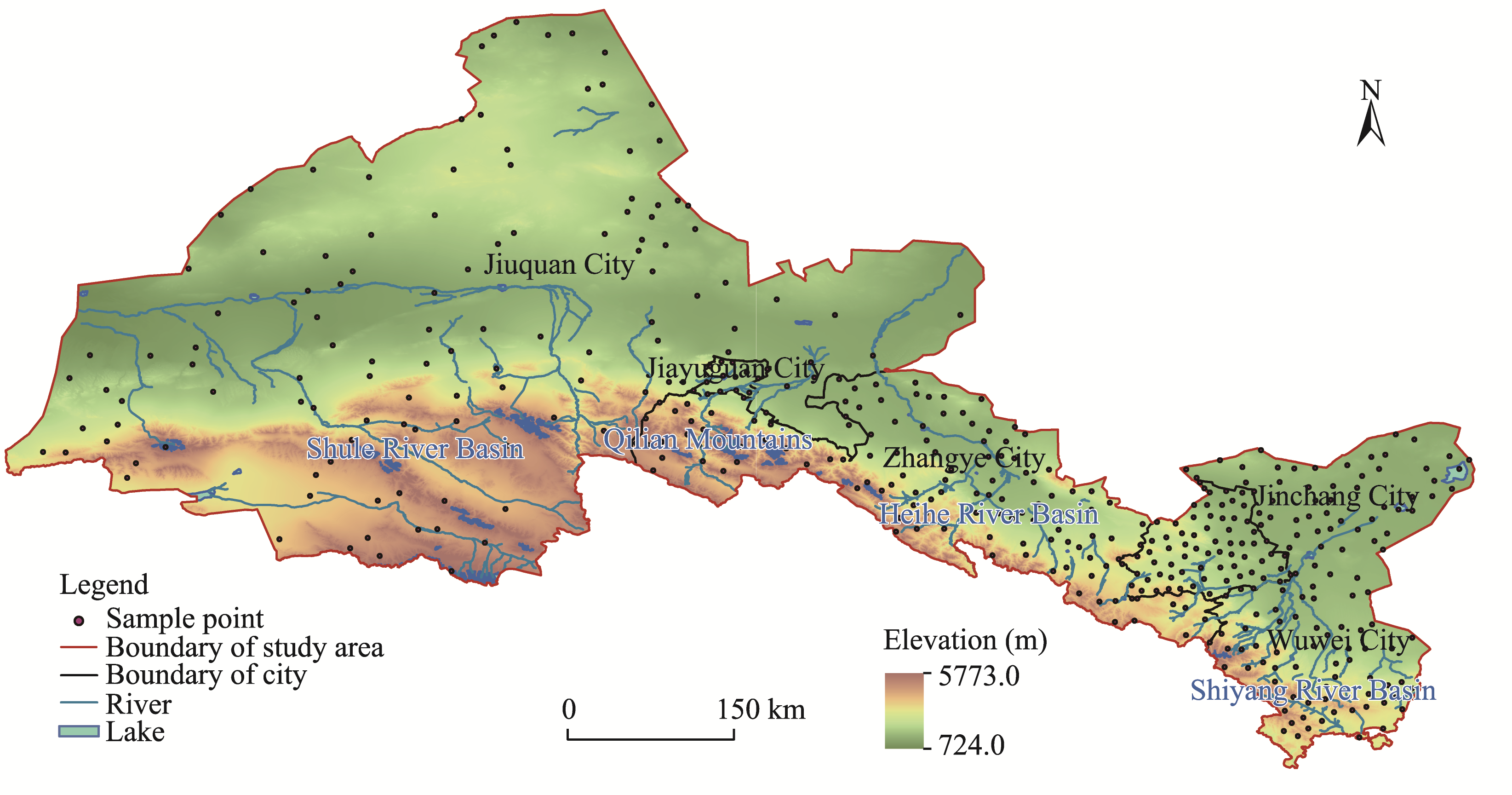
Unconstrained individual countries 2000-2020 (https://hub.worldpop.org)
Chen et al. (2024)
Table 1 Overview of the datasets used in this study
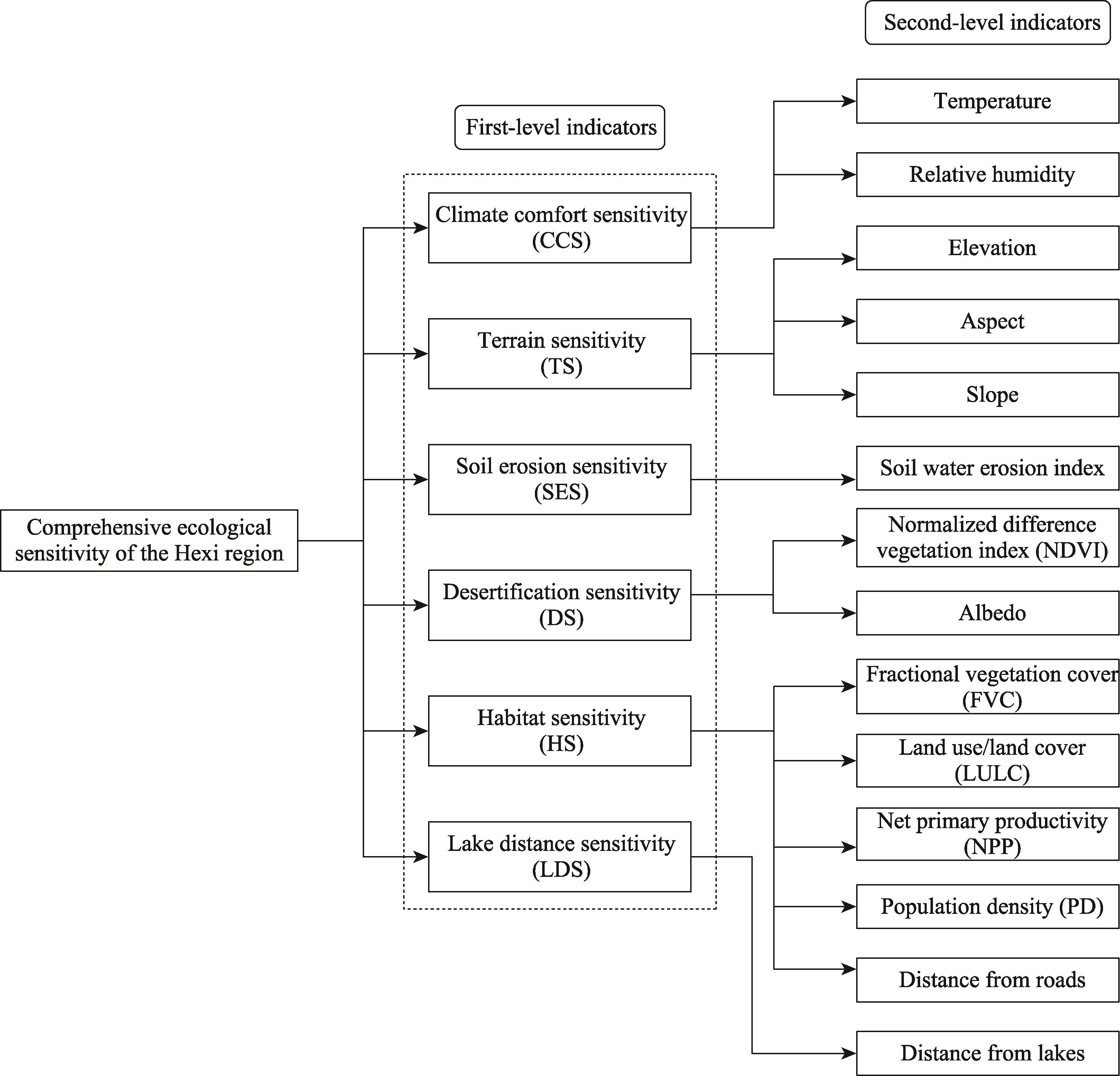
Fig. 2Hierarchical structure of comprehensive ecological sensitivity in the Hexi region
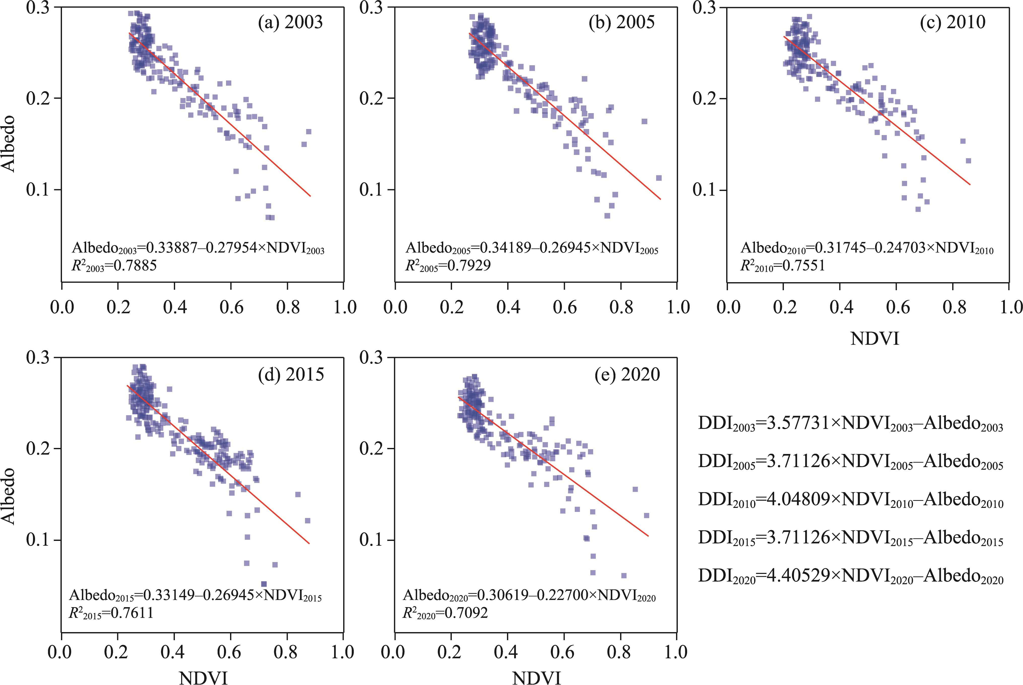
Fig. 3Linear regressions between albedo and NDVI in the Hexi region in 2003 (a), 2005 (b), 2010 (c), 2015 (d), and 2020 (e)
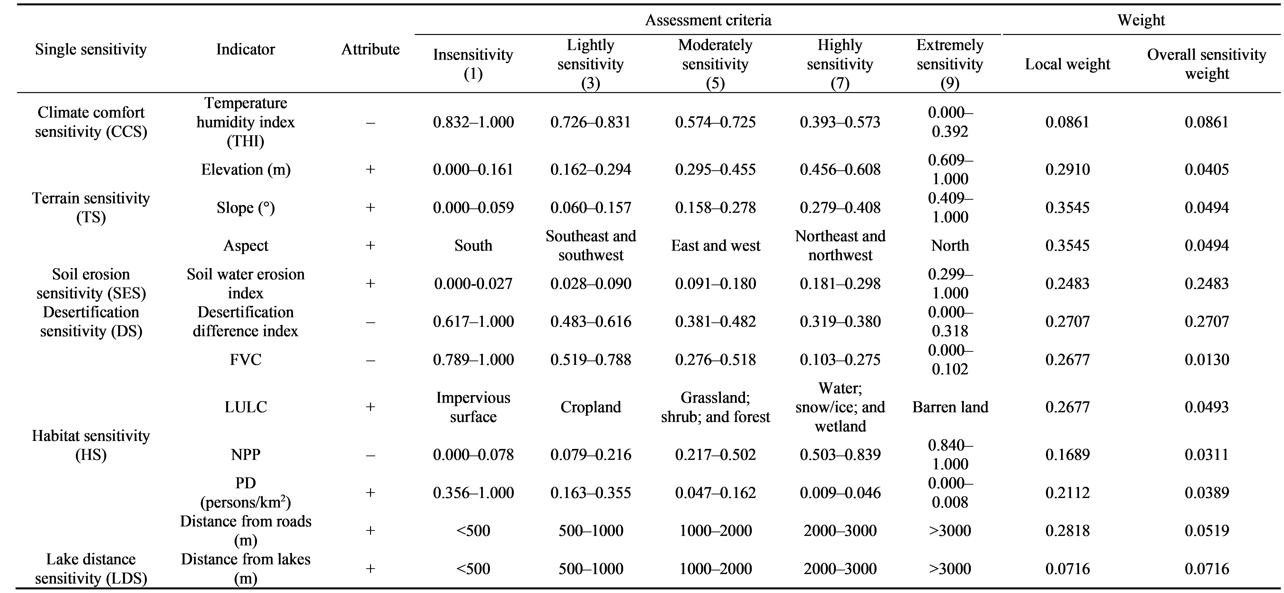
Table 2 Ecological sensitivity evaluation system in the Hexi region from 2003 to 2020
Interaction type
Relationship
Bi-linear enhancement
q(X1∩X2)>max(q(X1), q(X2))
Non-linear enhancement
q(X1∩X2)>q(X1)+q(X2)
Non-linear attenuation
q(X1∩X2)<min(q(X1), q(X2))
Mutual independence
q(X1∩X2)=q(X1)+q(X2)
Single-linear weakening
min(q(X1), q(X2))<q(X1∩X2)<max(q(X1), q(X2))
Table 3 Interaction types and corresponding relationships in Geographical detector
Fig. 4Spatio-temporal distribution of land-use types in the Hexi region in 2003 (a), 2005 (b), 2010 (c), 2015 (d), and 2020 (e). The pie charts show the area proportions of different land-use types.
Land classification
Area (km2)
2003
2005
2010
2015
2020
Cropland
12,476.01
12,538.47
12,996.04
13,808.57
14,192.30
Forest
2250.06
2260.49
2332.04
2457.25
2524.77
Shrub
227.04
199.78
116.22
141.49
240.29
Grassland
52,398.36
52,570.73
56,088.44
56,804.51
56,178.09
Water body
281.24
326.96
328.34
336.24
394.82
Snow/ice
1095.26
1274.09
1348.03
1251.33
1175.12
Barren land
178,514.18
178,064.06
174,008.24
172,409.52
172,486.40
Impervious surface
42.16
49.73
66.96
75.21
91.95
Wetland
0.04
0.05
0.05
0.24
0.61
Table 4 Statistical area of land-use classifications in the Hexi region from 2003 to 2020
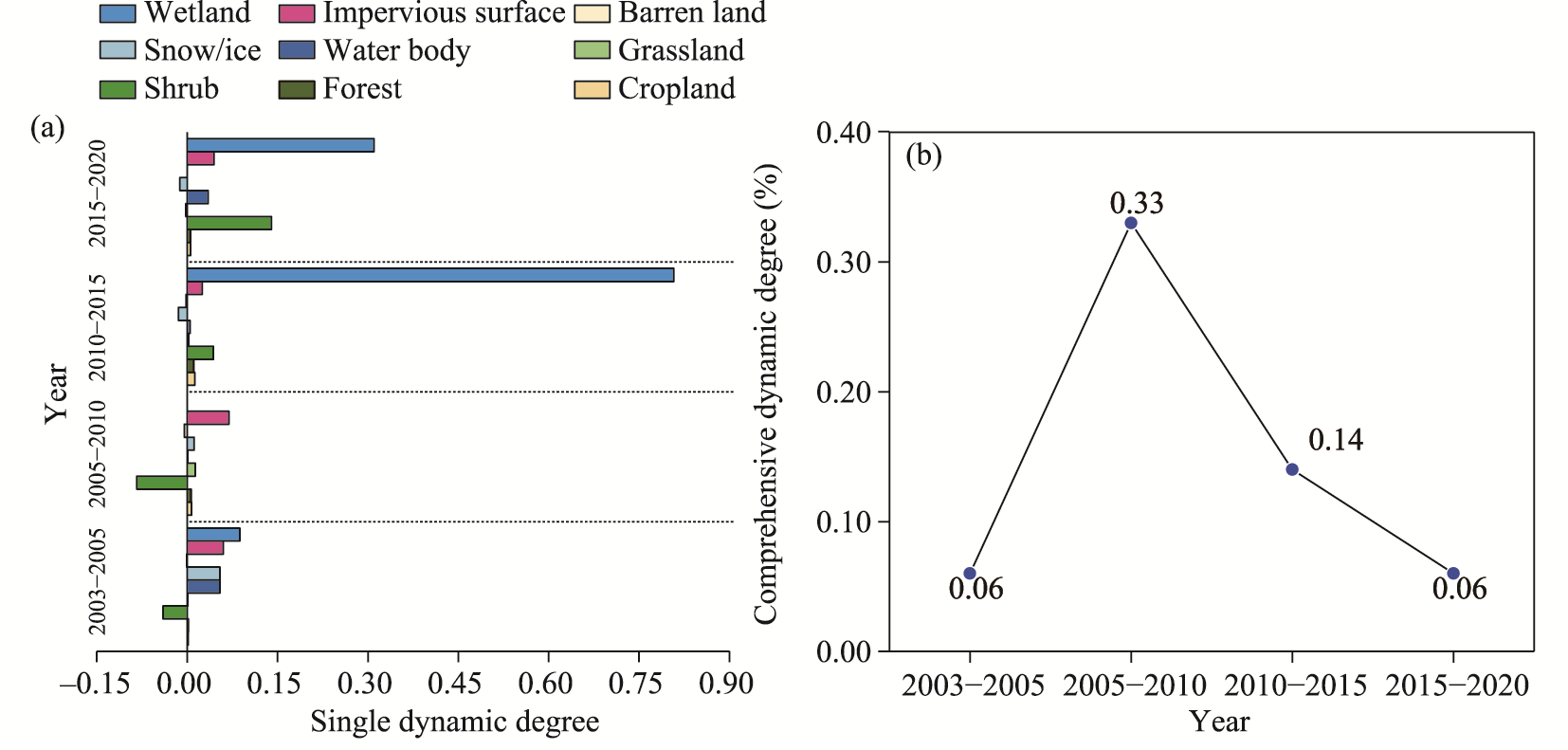
Fig. 5Dynamic degree of land-use in the Hexi region from 2003 to 2020. (a), single dynamic degree; (b), comprehensive dynamic degree.
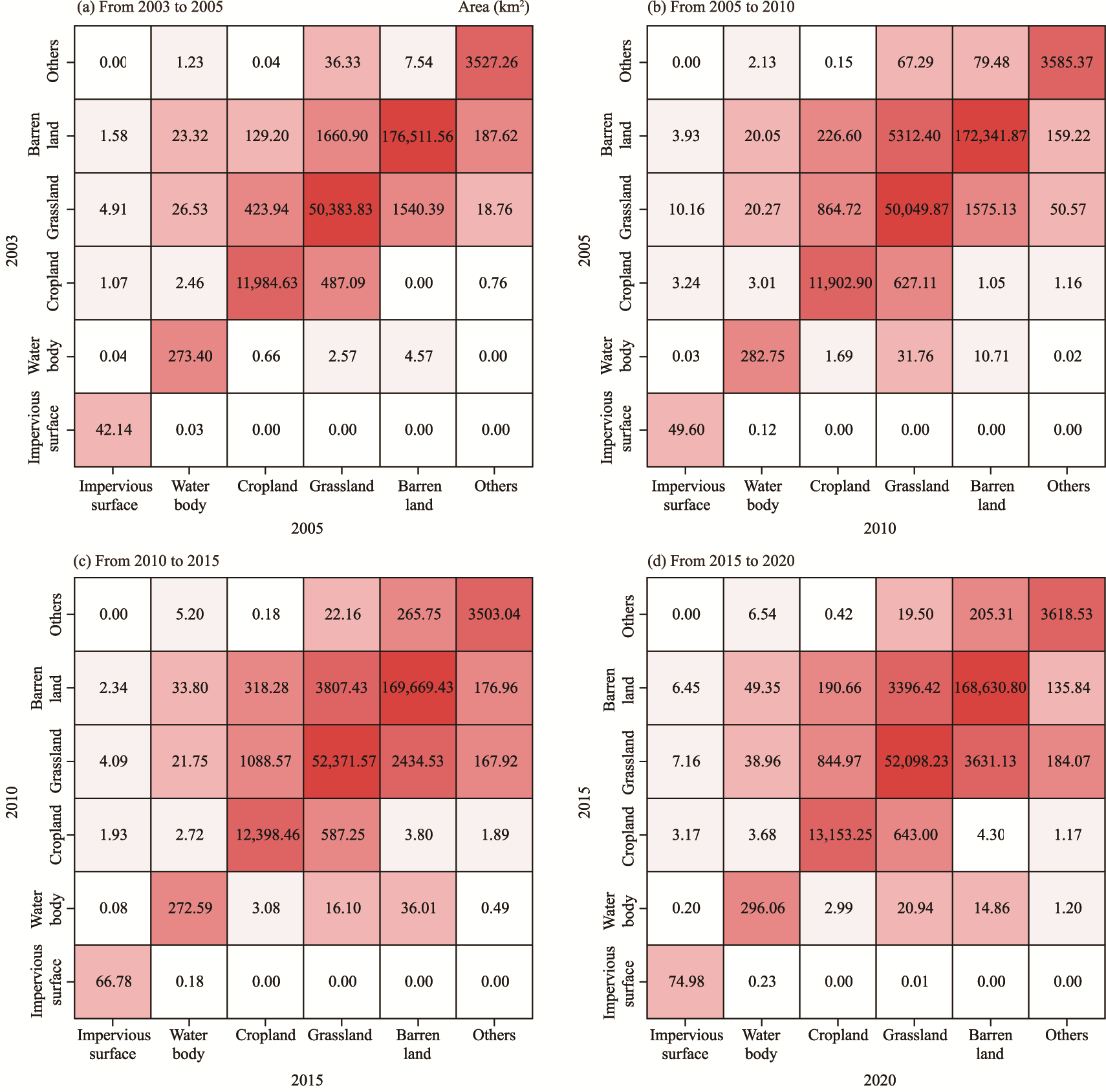
Fig. 6Land-use transition matrices of the Hexi region from 2003 to 2020. (a), 2003-2005; (b), 2005-2010; (c), 2010-2015; (d), 2015-2020. The rows represent the land-use types in the initial year (from), while the columns represent those in the subsequent year.
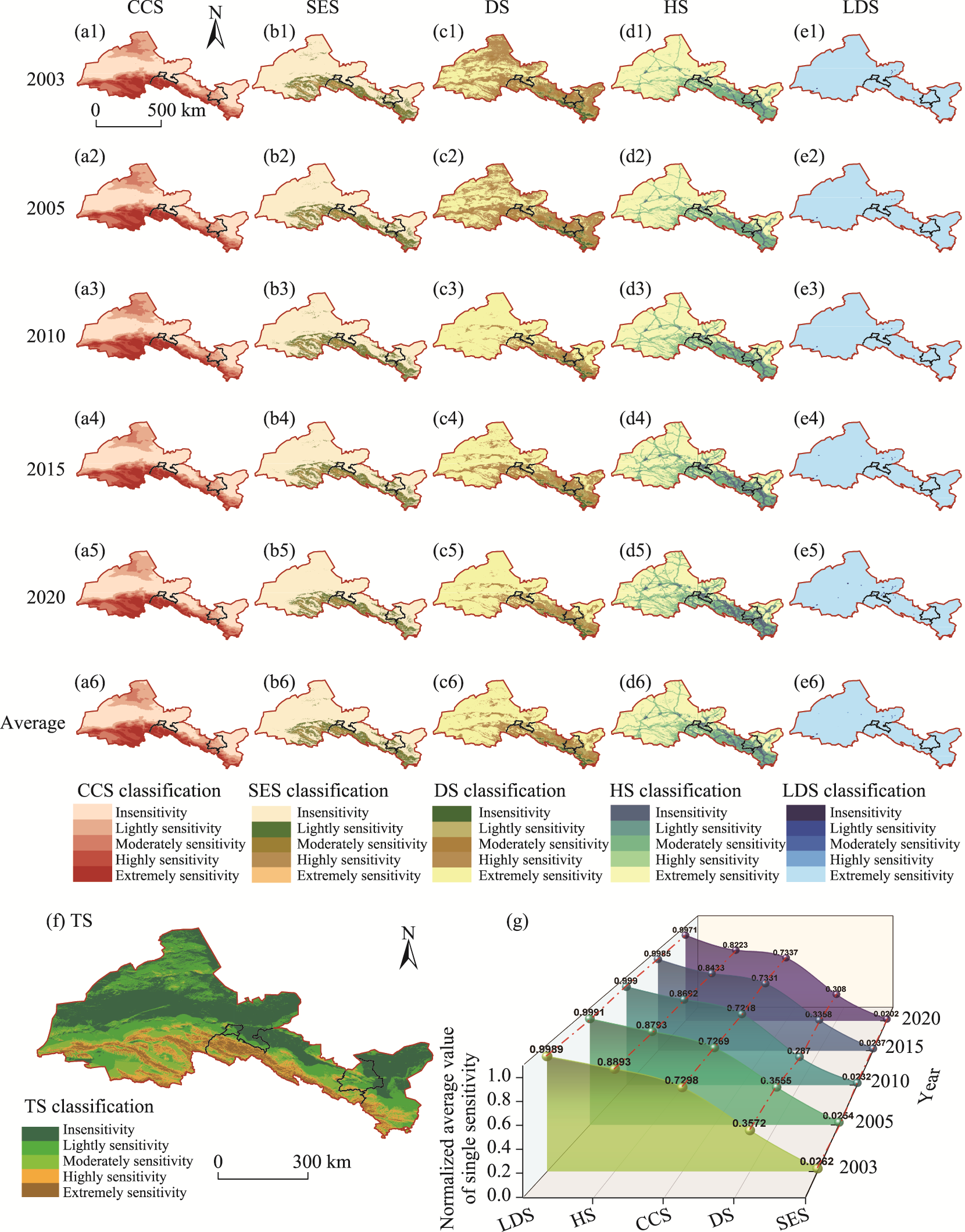
Fig. 7Spatial distribution (a-f) and temporal variation (g) of single sensitivity factors in the Hexi region from 2003 to 2020
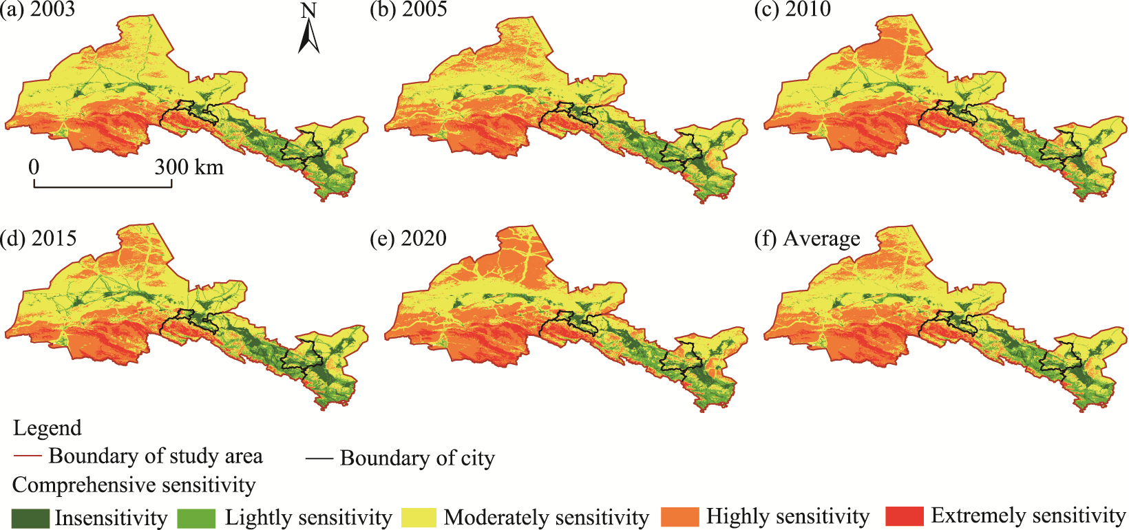
Fig. 8Spatio-temporal distribution of comprehensive ecological sensitivity in the Hexi region in 2003 (a), 2005 (b), 2010 (c), 2015 (d), 2020 (e), and average distribution during 2003-2020 (f)
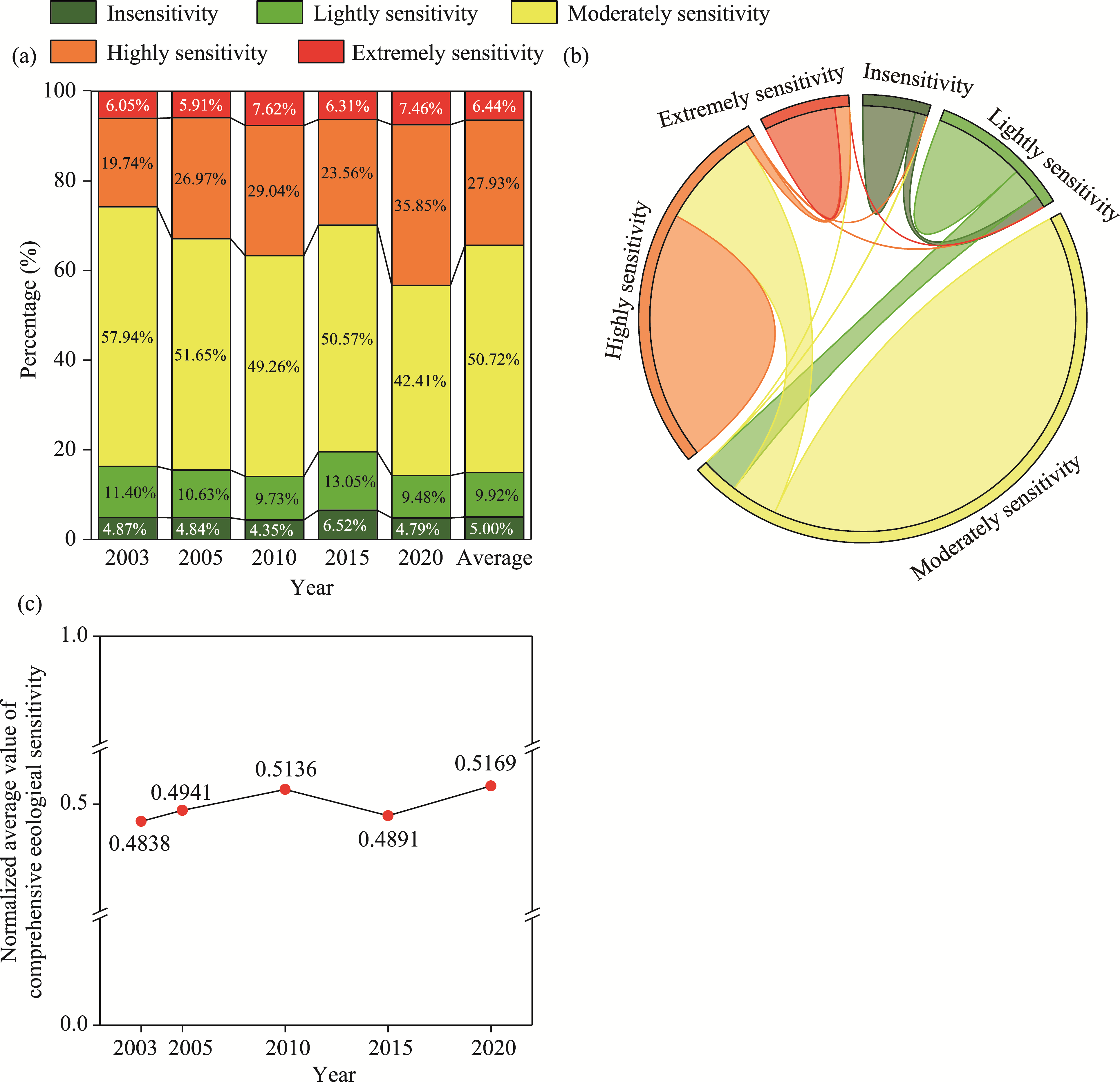
Fig. 9Comprehensive ecological sensitivity in the Hexi region from 2003 to 2020. (a), area proportions of comprehensive ecological sensitivity classifications; (b), chord diagram of cumulative transitions among ecological sensitivity levels across the four study intervals during 2003-2020; (c), annual average values variation.
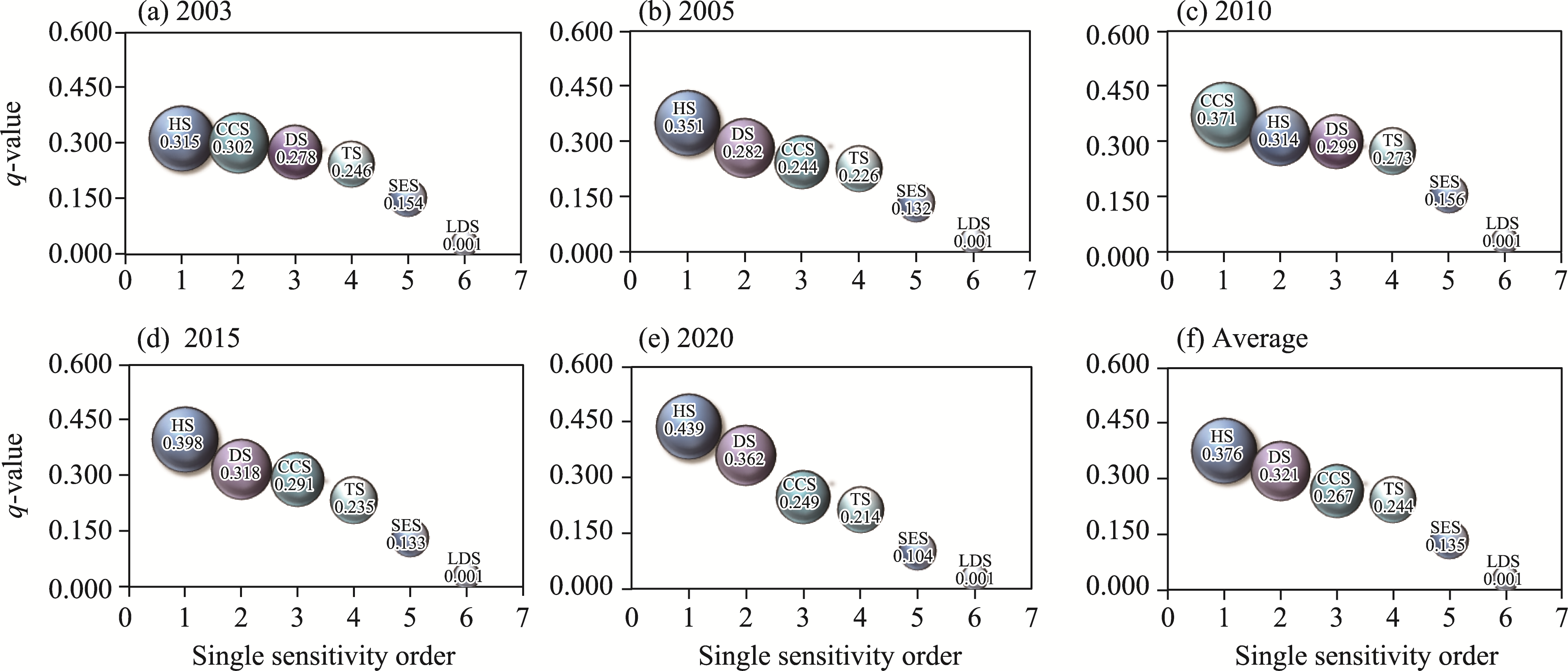
Fig. 10Temporal variation in the explanatory power of single sensitivity factors in the Hexi region in 2003 (a), 2005 (b), 2010 (c), 2015 (d), 2020 (e), and during 2003-2020 (f). The x-axis indicates the single sensitivity rank in descending order of q values for each period.
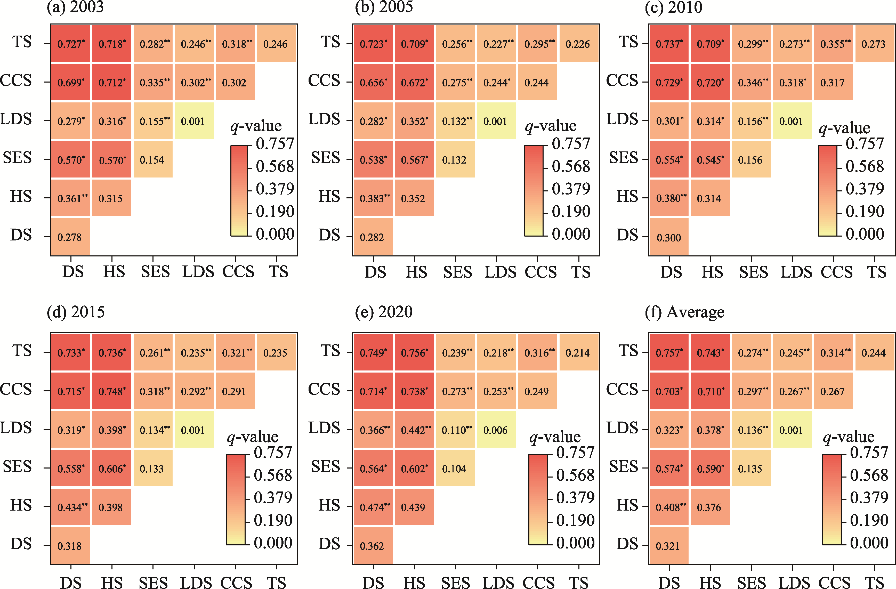
Fig. 11Interaction sensitivity analysis of ecological factors in the Hexi region in 2003 (a), 2005 (b), 2010 (c), 2015 (d), 2020 (e), and during 2003-2020 (f). * denotes non-linear enhancement, while ** denotes bi-linear enhancement.
[1]
Abson D J, Dougill A J, Stringer L C. 2012. Using principal component analysis for information-rich socio-ecological vulnerability mapping in Southern Africa. Applied Geography, 35(1-2): 515-524.
[2]
Becerril-Piña R, Díaz-Delgado C, Mastachi-Loza C A, et al. 2016. Integration of remote sensing techniques for monitoring desertification in Mexico. Human and Ecological Risk Assessment: An International Journal, 22(6): 1323-1340.
[3]
Chen Y, Zhang T B, Zhou X B, et al. 2024. Ecological sensitivity and its driving factors in the area along the Sichuan-Tibet Railway. Environment, Development and Sustainability, 26(8): 20189-20208.
[4]
Chen Y L, Lu D S, Luo L F, et al. 2018. Detecting irrigation extent, frequency, and timing in a heterogeneous arid agricultural region using MODIS time series, Landsat imagery, and ancillary data. Remote Sensing of Environment, 204: 197-211.
[5]
Dai X A, Gao Y, He X W, et al. 2021. Spatial-temporal pattern evolution and driving force analysis of ecological environment vulnerability in Panzhihua City. Environmental Science and Pollution Research, 28(6): 7151-7166.
[6]
Deng X H, Song Y L, Li Z X, et al. 2023. Evolution pattern of terrestrial ecological sensitivity in the Hexi region and its zoning governance. Journal of Desert Research, 43(5): 232-240. (in Chinese)
[7]
Dey C J, Tuononen E I, Hodgson E E, et al. 2024. What is habitat sensitivity? A quantitative definition relating resistance, resilience, and recoverability to environmental impacts. FACETS, 9: 1-9.
[8]
Ding Y T, Zhang M, Qian X Y, et al. 2019. Using the geographical detector technique to explore the impact of socioeconomic factors on PM2.5 concentrations in China. Journal of Cleaner Production, 211: 1480-1490.
[9]
Dossou J F, Li X X, Sadek M, et al. 2021. Hybrid model for ecological vulnerability assessment in Benin. Scientific Reports, 11(1): 2449, doi: 10.1038/s41598-021-81742-2.
[10]
Eggermont H, Verschuren D, Audenaert L, et al. 2010. Limnological and ecological sensitivity of Rwenzori mountain lakes to climate warming. Hydrobiologia, 648: 123-142.
[11]
Feng Q, Li Z X, Liu W, et al. 2016. Relationship between large scale atmospheric circulation, temperature and precipitation in the Extensive Hexi region, China, 1960-2011. Quaternary International, 392: 187-196.
[12]
Fraser R H, Olthof I, Pouliot D. 2009. Monitoring land cover change and ecological integrity in Canada's national parks. Remote Sensing of Environment, 113(7): 1397-1409.
[13]
Gibon F, Mialon A, Richaume P, et al. 2024. Estimating the uncertainties of satellite derived soil moisture at global scale. Science of Remote Sensing, 10: 100147, doi: 10.1016/j.srs.2024.100147.
[14]
Gómez Giménez M, de Jong R, Della Peruta R, et al. 2017. Determination of grassland use intensity based on multi-temporal remote sensing data and ecological indicators. Remote Sensing of Environment, 198: 126-139.
[15]
Gong J, Jin T T, Cao E J, et al. 2022. Is ecological vulnerability assessment based on the VSD model and AHP-Entropy method useful for loessial forest landscape protection and adaptative management? A case study of Ziwuling Mountain Region, China. Ecological Indicators, 143: 109379, doi: 10.1016/j.ecolind.2022.109379.
[16]
Gong W F, Wang H B, Wang X F, et al. 2017. Effect of terrain on landscape patterns and ecological effects by a gradient-based RS and GIS analysis. Journal of Forestry Research, 28(5): 1061-1072.
[17]
Han L Y, Zhang Z C, Zhang Q, et al. 2015. Desertification assessments in the Hexi corridor of northern China's Gansu Province by remote sensing. Natural Hazards, 75(3): 2715-2731.
[18]
He Y R, Chen Y H, Zhong L, et al. 2025. Spatiotemporal evolution of ecological environment quality and its drivers in the Helan Mountain, China. Journal of Arid Land, 17(2): 224-244.
[19]
Huang S, Feng Q, Lu Z X, et al. 2017. Trend analysis of water poverty index for assessment of water stress and water management polices: a case study in the Hexi Corridor, China. Sustainability, 9(5): 756, doi: 10.3390/su9050756.
[20]
Khosravi Mashizi A, Sharafatmandrad M. 2023. Dry forests conservation: A comprehensive approach linking ecosystem services to ecological drivers and sustainable management. Global Ecology and Conservation, 47: e02652, doi: 10.1016/j.gecco.2023.e02652.
[21]
Krishna B, Achari V S. 2023. Groundwater chemistry and entropy weighted water quality index of tsunami affected and ecologically sensitive coastal region of India. Heliyon, 9(10): e20431, doi: 10.1016/j.heliyon.2023.e20431.
[22]
Kumar S, Radhakrishnan N, Mathew S. 2014. Land use change modelling using a Markov model and remote sensing. Geomatics, Natural Hazards and Risk, 5(2): 145-156.
[23]
Lamchin M, Lee J Y, Lee W K, et al. 2016. Assessment of land cover change and desertification using remote sensing technology in a local region of Mongolia. Advances in Space Research, 57(1): 64-77.
[24]
Li X H, Zhang X B, Feng H Y, et al. 2024. Dynamic evolution and simulation of habitat quality in arid regions: A case study of the Hexi region, China. Ecological Modelling, 493: 110726, doi: 10.1016/j.ecolmodel.2024.110726.
[25]
Li Y G, Liu W, Feng Q, et al. 2023. The role of land use change in affecting ecosystem services and the ecological security pattern of the Hexi Regions, Northwest China. Science of The Total Environment, 855: 158940, doi: 10.1016/j.scitotenv.2022.158940.
[26]
Lin J K, Guan Q Y, Tian J, et al. 2020. Assessing temporal trends of soil erosion and sediment redistribution in the Hexi Corridor region using the integrated RUSLE-TLSD model. CATENA, 195: 104756, doi: 10.1016/j.catena.2020.104756.
[27]
Lü L T, Jiang R F, Zheng D F, et al. 2025. Impact of climate change and land use/cover change on water yield in the Liaohe River Basin, Northeast China. Journal of Arid Land, 17(2): 182-199.
[28]
Lü R F, Clarke K C, Zhang J M, et al. 2019. Spatial correlations among ecosystem services and their socio-ecological driving factors: A case study in the city belt along the Yellow River in Ningxia, China. Applied Geography, 108: 64-73.
[29]
Luo Q Y, Bao Y, Wang Z T, et al. 2023. Vulnerability assessment of urban remnant mountain ecosystems based on ecological sensitivity and ecosystem services. Ecological Indicators, 151: 110314, doi: 10.1016/j.ecolind.2023.110314.
[30]
Ma Z Y, Xie Y W, Jiao J Z, et al. 2011. The construction and application of an Albedo-NDVI based desertification monitoring model. Procedia Environmental Sciences, 10: 2029-2035.
[31]
Malczewski J. 2000. On the use of weighted linear combination method in GIS: Common and best practice approaches. Transactions in GIS, 4(1): 5-22.
[32]
Manolaki P, Zotos S, Vogiatzakis I N. 2020. An integrated ecological and cultural framework for landscape sensitivity assessment in Cyprus. Land Use Policy, 92: 104336, doi: 10.1016/j.landusepol.2019.104336.
[33]
McCluney K E, Poff N L, Palmer M A, et al. 2014. Riverine macrosystems ecology: sensitivity, resistance, and resilience of whole river basins with human alterations. Frontiers in Ecology and the Environment, 12(1): 48-58.
[34]
Mengist W, Soromessa T, Feyisa G L. 2021. Landscape change effects on habitat quality in a forest biosphere reserve: Implications for the conservation of native habitats. Journal of Cleaner Production, 329: 129778, doi: 10.1016/j.jclepro.2021.129778.
[35]
Pontius Jr R G, Huang J L, Jiang W L, et al. 2017. Rules to write mathematics to clarify metrics such as the land use dynamic degrees. Landscape Ecology, 32: 2249-2260.
[36]
Prince S D. 2019. Challenges for remote sensing of the Sustainable Development Goal SDG 15.3.1 productivity indicator. Remote Sensing of Environment, 234: 111428, doi: 10.1016/j.rse.2019.111428.
[37]
Qu W, Tan Y M, Li Z T, et al. 2020. Agricultural water use efficiency-A case study of inland-river basins in Northwest China. Sustainability, 12(23): 10192, doi: 10.3390/su122310192.
[38]
Quan B, Bai Y J, Römkens M J M, et al. 2015. Urban land expansion in Quanzhou City, China, 1995-2010. Habitat International, 48: 131-139.
[39]
Raj A, Sharma L K. 2023. Spatial E-PSR modelling for ecological sensitivity assessment for arid rangeland resilience and management. Ecological Modelling, 478: 110283, doi: 10.1016/j.ecolmodel.2023.110283.
[40]
Ramachandra T V, Bharath S, Subash Chandran M D, et al. 2018. Salient ecological sensitive regions of central Western Ghats, India. Earth Systems and Environment, 2: 15-34.
[41]
Ran Y H, Liu J P, Tian F, et al. 2017. Mapping mountain torrent hazards in the Hexi Corridor using an evidential reasoning approach. IOP Conference Series: Earth and Environmental Science, 57(1): 012014, doi: 10.1088/1755-1315/57/1/012014.
[42]
Rietkerk M, Dekker S C, de Ruiter P C, et al. 2004. Self-organized patchiness and catastrophic shifts in ecosystems. Science, 305(5692): 1926-1929.
[43]
Rossi P, Pecci A, Amadio V, et al. 2008. Coupling indicators of ecological value and ecological sensitivity with indicators of demographic pressure in the demarcation of new areas to be protected: The case of the Oltrepò Pavese and the Ligurian-Emilian Apennine area (Italy). Landscape and Urban Planning, 85(1): 12-26.
[44]
Schlesinger W H, Reynolds J F, Cunningham G L, et al. 1990. Biological feedbacks in global desertification. Science, 247(4946): 1043-1048.
[45]
Segnalini M, Bernabucci U, Vitali A, et al. 2013. Temperature humidity index scenarios in the Mediterranean basin. International Journal of Biometeorology, 57: 451-458.
[46]
Shan R, Tian P, Lu A, et al. 2025. Soil erosion and sediment connectivity variations in the Hantaichuan Watershed, northern Loess Plateau, China from 1995 to 2020. Journal of Arid Land, 17(12): 1761-1784.
[47]
Shao W Y, Wang Q Z, Guan Q Y, et al. 2023. Environmental sensitivity assessment of land desertification in the Hexi Corridor, China. CATENA, 220: 106728, doi: 10.1016/j.catena.2022.106728.
[48]
Shen Z Y, Wang Y F, Su H, et al. 2022. A bi-directional strategy to detect land use function change using time-series Landsat imagery on Google Earth Engine: A case study of Huangshui River Basin in China. Science of Remote Sensing, 5: 100039, doi: 10.1016/j.srs.2022.100039.
[49]
Sun D Y, Ji Z H, Wang Y K, et al. 2024. Assessment and forecasting of water ecological security and obstacle factor diagnosis in the Hexi Corridor of Northwest China. Scientific Reports, 14(1): 23507, doi: 10.1038/s41598-024-74925-0.
[50]
Takada T, Miyamoto A, Hasegawa S F. 2010. Derivation of a yearly transition probability matrix for land-use dynamics and its applications. Landscape Ecology, 25: 561-572.
[51]
Tarantino C, De Lucia M, Zollo L, et al. 2025. Combination of GEOBIA and data-driven approach for grassland habitat mapping in the Alta Murgia National Park. Science of Remote Sensing, 11: 100214, doi: 10.1016/j.srs.2025.100214.
[52]
Taylor C M, Lambin E F, Stephenne N, et al. 2002. The influence of land use change on climate in the Sahel. Journal of Climate, 15(24): 3615-3629.
[53]
Thomas J, Joseph S, Thrivikramji K P. 2018. Assessment of soil erosion in a tropical mountain river basin of the southern Western Ghats, India using RUSLE and GIS. Geoscience Frontiers, 9(3): 893-906.
[54]
Vorovencii I. 2017. Applying the change vector analysis technique to assess the desertification risk in the south-west of Romania in the period 1984-2011. Environmental Monitoring and Assessment, 189(10): 524, doi: 10.1007/s10661-017-6234-6.
[55]
Walters D, Kotze D C, Rebelo A, et al. 2021. Validation of a rapid wetland ecosystem services assessment technique using the Delphi method. Ecological Indicators, 125: 107511, doi: 10.1016/j.ecolind.2021.107511.
[56]
Wang W, Yang J, Yang G S. 2024. Coordination characteristics and influencing mechanisms of habitat quality, ecological sensitivity and net primary production: A case study on Yangtze River Economic Belt in China. Environmental Development, 49: 100969, doi: 10.1016/j.envdev.2024.100969.
[57]
Wei W, Li Z Y, Xie B B, et al. 2020. Spatial distance-based integrated evaluation of environmentally sensitivity for ecological management in Northwest China. Ecological Indicators, 118: 106753, doi: 10.1016/j.ecolind.2020.106753.
[58]
Wei Y B, Tao H, Kundzewicz Z W, et al. 2025. Natural and anthropogenic contributions to desertification in Central Asia. CATENA, 257: 109154, doi: 10.1016/j.catena.2025.109154.
[59]
Wu C Y, Chen B W, Huang X J, et al. 2020. Effect of land-use change and optimization on the ecosystem service values of Jiangsu Province, China. Ecological Indicators, 117: 106507, doi: 10.1016/j.ecolind.2020.106507.
[60]
Wu J R, Chen X L, Lu J Z. 2022. Assessment of long and short-term flood risk using the multi-criteria analysis model with the AHP-Entropy method in Poyang Lake basin. International Journal of Disaster Risk Reduction, 75: 102968, doi: 10.1016/j.ijdrr.2022.102968.
[61]
Xiao H, Shao H Y, Long J M, et al. 2023. Spatial-temporal pattern evolution and geological influence factors analysis of ecological vulnerability in Western Sichuan mountain region. Ecological Indicators, 155: 110980, doi: 10.1016/j.ecolind.2023.110980.
[62]
Xiao S J, Xia H N, Zhai J, et al. 2024. Trade-off and synergy relationships and driving factor analysis of ecosystem services in the Hexi Region. Remote Sensing, 16(17): 3147, doi: 10.3390/rs16173147.
[63]
Yan J N, Wang S, Feng J X, et al. 2025. New 30-m resolution dataset reveals declining soil erosion with regional increases across Chinese mainland (1990-2022). Remote Sensing of Environment, 323: 114681, doi: 10.1016/j.rse.2025.114681.
[64]
Yang L Q, Guan Q Y, Lin J K, et al. 2021. Evolution of NDVI secular trends and responses to climate change: A perspective from nonlinearity and nonstationarity characteristics. Remote Sensing of Environment, 254: 112247, doi: 10.1016/j.rse.2020.112247.
[65]
Yilmaz F C, Zengin M, Tekin Cure C. 2020. Determination of ecologically sensitive areas in Denizli Province using geographic information systems (GIS) and analytical hierarchy process (AHP). Environmental Monitoring and Assessment, 192(9): 589, doi: 10.1007/s10661-020-08514-9.
[66]
Zeng Y N, Xiang N P, Feng Z D, et al. 2006. Albedo-NDVI space and remote sensing synthesis index models for desertification monitoring. Scientia Geographica Sinica, 26(1): 75-81. (in Chinese)
[67]
Zhang B T, Feng Q, Li Z X, et al. 2024a. Land use/cover-related ecosystem service value in fragile ecological environments: A case study in Hexi Region, China. Remote Sensing, 16(3): 563, doi: 10.3390/rs16030563.
[68]
Zhang J, Guan Q Y, Du Q Q, et al. 2022. Spatial and temporal dynamics of desertification and its driving mechanism in Hexi region. Land Degradation & Development, 33(17): 3539-3556.
[69]
Zhang J, Guan Q Y, Zhang Z P, et al. 2024b. Characteristics of spatial and temporal dynamics of vegetation and its response to climate extremes in ecologically fragile and climate change sensitive areas-A case study of Hexi region. CATENA, 239: 107910, doi: 10.1016/j.catena.2024.107910.
[70]
Zhang Z F, Wang C M, Lü B H. 2024c. Comparative analysis of ecological sensitivity assessment using the coefficient of variation method and machine learning. Environmental Monitoring and Assessment, 196(10): 1000, doi: 10.1007/s10661-024-13195-9.
[71]
Zhang Z J, Song X X. 2026. Landscape ecological risk assessment and multi-scenario simulation of land use based on the Markov-FLUS model: A case study of the Hexi Corridor. Sustainability, 18(8): 3892, doi: 10.3390/su18083892.
[72]
Zhao J C, Ji G X, Tian Y, et al. 2018. Environmental vulnerability assessment for mainland China based on entropy method. Ecological Indicators, 91: 410-422.
[73]
Zhao Y B, Wang J, Zhang G L, et al. 2023. Divergent trends in grassland degradation and desertification under land use and climate change in Central Asia from 2000 to 2020. Ecological Indicators, 154: 110737, doi: 10.1016/j.ecolind.2023.110737.
[74]
Zhu H S, Zhai J, Hou P, et al. 2022. Divergent trends of ecosystem status and services in the Hexi Corridor. Frontiers in Environmental Science, 10: 1008441, doi: 10.3389/fenvs.2022.1008441.