| Research article |
|

|
|
|
| Adaptability of machine learning methods and hydrological models to discharge simulations in data-sparse glaciated watersheds |
JI Huiping1,2, CHEN Yaning1,2,*( ), FANG Gonghuan1,2, LI Zhi1,2, DUAN Weili1,2, ZHANG Qifei1,2 ), FANG Gonghuan1,2, LI Zhi1,2, DUAN Weili1,2, ZHANG Qifei1,2 |
1State Key Laboratory of Desert and Oasis Ecology, Xinjiang Institute of Ecology and Geography, Chinese Academy of Sciences, Urumqi 830011, China
2University of Chinese Academy of Sciences, Beijing 100049, China |
|
|
|
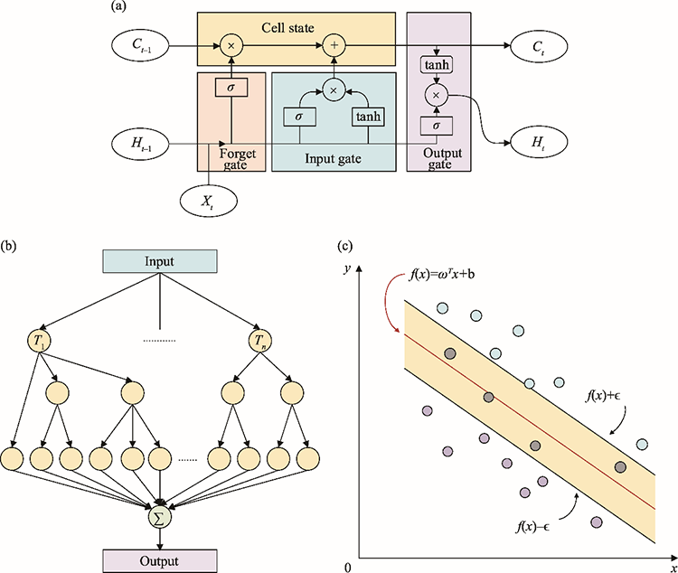
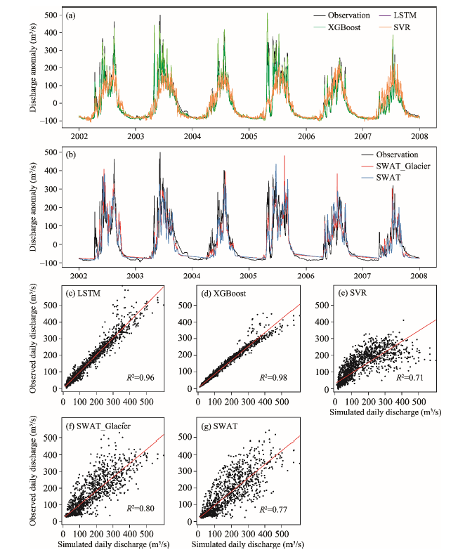
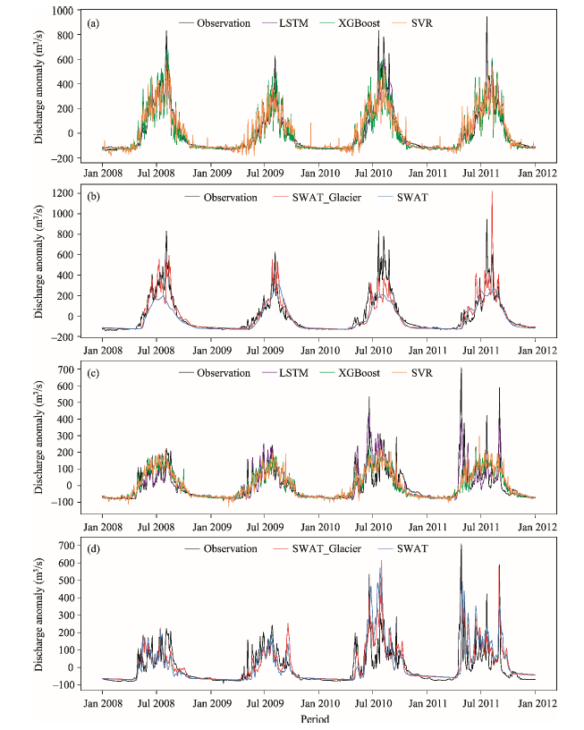
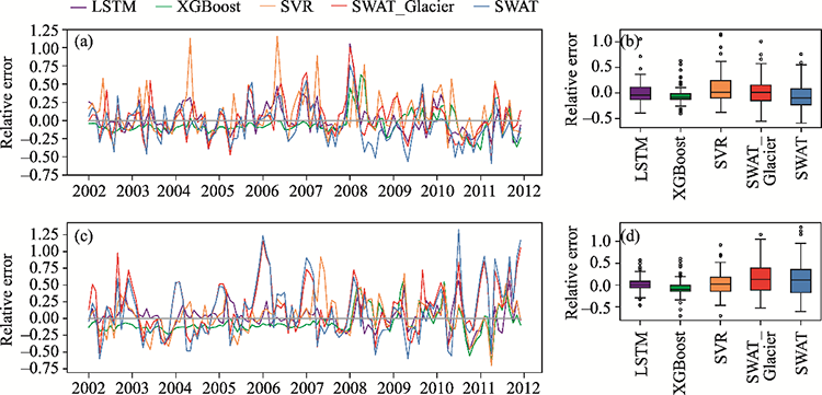
Abstract The accurate simulation and prediction of runoff in alpine glaciated watersheds is of increasing importance for the comprehensive management and utilization of water resources. In this study, long short-term memory (LSTM), a state-of-the-art artificial neural network algorithm, is applied to simulate the daily discharge of two data-sparse glaciated watersheds in the Tianshan Mountains in Central Asia. Two other classic machine learning methods, namely extreme gradient boosting (XGBoost) and support vector regression (SVR), along with a distributed hydrological model (Soil and Water Assessment Tool (SWAT) and an extended SWAT model (SWAT_Glacier) are also employed for comparison. This paper aims to provide an efficient and reliable method for simulating discharge in glaciated alpine regions that have insufficient observed meteorological data. The two typical basins in this study are the main tributaries (the Kumaric and Toxkan rivers) of the Aksu River in the south Tianshan Mountains, which are dominated by snow and glacier meltwater and precipitation. Our comparative analysis indicates that simulations from the LSTM shows the best agreement with the observations. The performance metrics Nash-Sutcliffe efficiency coefficient (NS) and correlation coefficient (R2) of LSTM are higher than 0.90 in both the training and testing periods in the Kumaric River Basin, and NS and R 2 are also higher than 0.70 in the Toxkan River Basin. Compared to classic machine learning algorithms, LSTM shows significant advantages over most evaluating indices. XGBoost also has high NS value in the training period, but is prone to overfitting the discharge. Compared with the widely used hydrological models, LSTM has advantages in predicting accuracy, despite having fewer data inputs. Moreover, LSTM only requires meteorological data rather than physical characteristics of underlying data. As an extension of SWAT, the SWAT_Glacier model shows good adaptability in discharge simulation, outperforming the original SWAT model, but at the cost of increasing the complexity of the model. Compared with the oftentimes complex semi-distributed physical hydrological models, the LSTM method not only eliminates the tedious calibration process of hydrological parameters, but also significantly reduces the calculation time and costs. Overall, LSTM shows immense promise in dealing with scarce meteorological data in glaciated catchments.
|
|
Received: 07 April 2021
Published: 10 June 2021
|
|
Corresponding Authors:
|
About author: CHEN Yaning (E-mail: chenyn@ms.xjb.ac.cn)
|
|
|
| [1] |
Aggarwal S K, Goel A, Singh V P. 2012. Stage and discharge forecasting by SVM and ANN techniques. Water Resources Management, 26:3705-3724.
doi: 10.1007/s11269-012-0098-x
|
|
|
| [2] |
Ajami N, Gupta H, Wagener T, et al. 2004. Calibration of a semi-distributed hydrologic model for streamflow estimation along a river system. Journal of Hydrology, 298:112-135.
doi: 10.1016/j.jhydrol.2004.03.033
|
|
|
| [3] |
Arnold J G, Srinivasan R, Muttiah R S, et al. 1998. Large area hydrologic modeling and assessment—Part 1: Model development. JAWRA Journal of the American Water Resources Association, 34:73-89.
doi: 10.1111/jawr.1998.34.issue-1
|
|
|
| [4] |
Bengio Y, Simard P, Frasconi P. 1994. Learning Long-Term dependencies with gradient descent is difficult. IEEE Transactions on Neural Networks, 5:157-166.
pmid: 18267787
|
|
|
| [5] |
Chen T Q, Guestrin C. 2016. XGBoost: A scalable tree boosting system. In: Proceedings of the 22nd ACM SIGKDD International Conference on Knowledge Discovery and Data Mining. San Francisco: Special Interest Group on Management of Data, 785-794.
|
|
|
| [6] |
Chen X, Long D, Hong Y, et al. 2017. Improved modeling of snow and glacier melting by a progressive two-stage calibration strategy with GRACE and multisource data: How snow and glacier meltwater contributes to the runoff of the Upper Brahmaputra River basin? Water Resources Research, 53:2431-2466.
doi: 10.1002/2016WR019656
|
|
|
| [7] |
Chen Y N, Takeuchi K, Xu C C, et al. 2006. Regional climate change and its effects on river runoff in the Tarim Basin, China. Hydrological Processes, 20:2207-2216.
doi: 10.1002/(ISSN)1099-1085
|
|
|
| [8] |
Chen Y N, Li W H, Deng H J, et al. 2016. Changes in Central Asia's water tower: past, present and future. Scientific Reports, 6:35458, doi: 10.1038/srep35458.
doi: 10.1038/srep35458
|
|
|
| [9] |
Chen Y N, Li W H, Fang G H, et al. 2017. Review article: Hydrological modeling in glacierized catchments of Central Asia - status and challenges. Hydrology and Earth System Sciences, 21:669-684.
doi: 10.5194/hess-21-669-2017
|
|
|
| [10] |
Cheng C T, Feng Z K, Niu W J, et al. 2015. Heuristic methods for reservoir monthly inflow forecasting: A case study of Xinfengjiang Reservoir in Pearl River, China. Water, 7:4477-4495.
doi: 10.3390/w7084477
|
|
|
| [11] |
Duethmann D, Bolch T, Farinotti D, et al. 2015. Attribution of streamflow trends in snow and glacier melt-dominated catchments of the Tarim River, Central Asia. Water Resources Research, 51:4727-4750.
doi: 10.1002/2014WR016716
|
|
|
| [12] |
Duethmann D, Menz C, Jiang T, et al. 2016. Projections for headwater catchments of the Tarim River reveal glacier retreat and decreasing surface water availability but uncertainties are large. Environmental Research Letters, 11:054024, doi: 10.1088/1748-9326/11/5/054024.
doi: 10.1088/1748-9326/11/5/054024
|
|
|
| [13] |
Fan Y T, Chen Y N, Li W H. 2014. Increasing precipitation and baseflow in Aksu River since the 1950s. Quaternary International, 336:26-34.
doi: 10.1016/j.quaint.2013.09.037
|
|
|
| [14] |
Fang K, Shen C P, Kifer D, et al. 2017. Prolongation of SMAP to spatiotemporally seamless coverage of continental U.S. using a deep learning neural network. Geophysical Research Letters, 44, doi: 10.1002/2017gl075619.
doi: 10.1002/2017gl075619
|
|
|
| [15] |
Fang K, Shen C P. 2019. Near-real-time forecast of satellite-based soil moisture using long short-term memory with an adaptive data integration kernel. Journal of Hydrometeorology, 21:399-413.
doi: 10.1175/JHM-D-19-0169.1
|
|
|
| [16] |
Feng D P, Fang K, Shen C P. 2020. Enhancing streamflow forecast and extracting insights using Long-Short Term Memory networks with data integration at continental scales. Water Resources Research, 56:e2019WR026793, doi: 10.1029/2019WR026793.
doi: 10.1029/2019WR026793
|
|
|
| [17] |
Finger D, Vis M, Huss M, et al. 2015. The value of multiple data set calibration versus model complexity for improving the performance of hydrological models in mountain catchments. Water Resources Research, 51:1939-1958.
doi: 10.1002/wrcr.v51.4
|
|
|
| [18] |
Fu M L, Fan T C, Ding Z A, et al. 2020. Deep learning data-intelligence model based on adjusted forecasting window scale: Application in daily streamflow simulation. IEEE Access, 8:32632-32651.
doi: 10.1109/Access.6287639
|
|
|
| [19] |
Gao S, Huang Y F, Zhang S, et al. 2020. Short-term runoff prediction with GRU and LSTM networks without requiring time step optimization during sample generation. Journal of Hydrology, 589:125188, doi: 10.1016/j.jhydrol.2020.125188.
doi: 10.1016/j.jhydrol.2020.125188
|
|
|
| [20] |
Greff K, Srivastava R K, Koutník J, et al. 2017. LSTM: A search space odyssey. IEEE Transactions on Neural Networks and Learning Systems, 28:2222-2232.
doi: 10.1109/TNNLS.2016.2582924
|
|
|
| [21] |
Greve P, Burek P, Wada Y. 2020. Using the Budyko framework for calibrating a global hydrological model. Water Resources Research, 56:e2019WR026280, doi: 10.1029/2019WR026280.
doi: 10.1029/2019WR026280
|
|
|
| [22] |
Hochreiter S, Schmidhuber J. 1997. Long short-term memory. Neural Computation, 9:1735-1780.
pmid: 9377276
|
|
|
| [23] |
Hsu K, Gupta H V, Sorooshia S. 1995. Artificial neural network modeling of the rainfall-runoff process. Water Resources Research, 31:2517-2530.
doi: 10.1029/95WR01955
|
|
|
| [24] |
Hu C H, Wu Q, Li H, et al. 2018. Deep learning with a Long Short-Term Memory networks approach for rainfall-runoff simulation. Water, 10:1543, doi: 10.3390/w10111543.
doi: 10.3390/w10111543
|
|
|
| [25] |
Hu Y C, Yan L, Hang T, et al. 2020. Stream-flow forecasting of small rivers based on LSTM. arXiv e-prints. arXiv:2001.05681. https://arxiv.org/abs/2001.05681.
|
|
|
| [26] |
Immerzeel WW, van Beek L, Bierkens M. 2010. Climate change will affect the Asian water towers. Science, 328:1382-1385.
doi: 10.1126/science.1183188
pmid: 20538947
|
|
|
| [27] |
Immerzeel W W, Lutz A F, Andrade M, et al. 2020. Importance and vulnerability of the world's water towers. Nature, 577:364-369.
doi: 10.1038/s41586-019-1822-y
|
|
|
| [28] |
Ji H P, Fang G H, Yang J, et al. 2019. Multi-objective calibration of a distributed hydrological model in a highly glacierized watershed in Central Asia. Water, 11:554, doi: 10.3390/w11030554.
doi: 10.3390/w11030554
|
|
|
| [29] |
Jodar J, Carpintero E, Martos-Rosillo S, et al. 2018. Combination of lumped hydrological and remote-sensing models to evaluate water resources in a semi-arid high altitude ungauged watershed of Sierra Nevada (Southern Spain). Science of the Total Environment, 625:285-300.
doi: 10.1016/j.scitotenv.2017.12.300
|
|
|
| [30] |
Kingma D, Ba J. 2015. Adam: A Method for Stochastic Optimization. In: Proceedings of the 3rd International Conference on Learning Representations. San Diego: Computational and Biological Learning Society.
|
|
|
| [31] |
Kratzert F, Klotz D, Brenner C, et al. 2018. Rainfall-runoff modelling using Long Short-Term Memory (LSTM) networks. Hydrology and Earth System Sciences, 22:6005-6022.
doi: 10.5194/hess-22-6005-2018
|
|
|
| [32] |
Kratzert F, Klotz D, Herrnegger M, et al. 2019a. Toward improved predictions in ungauged basins: Exploiting the power of machine learning. Water Resources Research, 55:11344-11354.
doi: 10.1029/2019WR026065
|
|
|
| [33] |
Kratzert F, Klotz D, Shalev G, et al. 2019b. Towards learning universal, regional, and local hydrological behaviors via machine learning applied to large-sample datasets. Hydrology and Earth System Sciences, 23:5089-5110.
doi: 10.5194/hess-23-5089-2019
|
|
|
| [34] |
Kratzert F, Klotz D, Hochreiter S, et al. 2020. A note on leveraging synergy in multiple meteorological datasets with deep learning for rainfall-runoff modeling. Hydrology and Earth System Sciences Discussion. [Preprint]. https://doi.org/10.5194/hess-2020-221, in review.
|
|
|
| [35] |
Li W, Kiaghadi A, Dawson C. 2021. High temporal resolution rainfall-runoff modeling using long-short-term-memory (LSTM) networks. Neural Computing and Applications, 33:1261-1278.
doi: 10.1007/s00521-020-05010-6
|
|
|
| [36] |
Li Z L, Shao Q X, Xu Z X, et al. 2010. Analysis of parameter uncertainty in semi-distributed hydrological models using bootstrap method: A case study of SWAT model applied to Yingluoxia watershed in northwest China. Journal of Hydrology, 385:76-83.
doi: 10.1016/j.jhydrol.2010.01.025
|
|
|
| [37] |
Luo X G, Yuan X H, Zhu S, et al. 2019. A hybrid support vector regression framework for streamflow forecast. Journal of Hydrology, 568:184-193.
doi: 10.1016/j.jhydrol.2018.10.064
|
|
|
| [38] |
Maier H R, Jain A, Dandy G C, et al. 2010. Methods used for the development of neural networks for the prediction of water resource variables in river systems: Current status and future directions. Environmental Modelling & Software, 25:891-909.
|
|
|
| [39] |
Michaud J, Sorooshian S. 1994. Comparison of simple versus complex distributed runoff models on a midsized semiarid watershed. Water Resources Research, 30:593-605.
doi: 10.1029/93WR03218
|
|
|
| [40] |
Ni L L, Wang D, Wu J F, et al. 2020. Streamflow forecasting using extreme gradient boosting model coupled with Gaussian mixture model. Journal of Hydrology, 586:124901, doi: 10.1016/j.jhydrol.2020.124901.
doi: 10.1016/j.jhydrol.2020.124901
|
|
|
| [41] |
Qin J, Yang K, Liang S L, et al. 2009. The altitudinal dependence of recent rapid warming over the Tibetan Plateau. Climatic Change, 97:321, doi: 10.1007/s10584-009-9733-9.
doi: 10.1007/s10584-009-9733-9
|
|
|
| [42] |
Razavi T, Coulibaly P. 2013. Streamflow prediction in ungauged basins: Review of regionalization methods. Journal of Hydrologic Engineering, 18:958-975.
doi: 10.1061/(ASCE)HE.1943-5584.0000690
|
|
|
| [43] |
Reichstein M, Camps-Valls G, Stevens B, et al. 2019. Deep learning and process understanding for data-driven earth system science. Nature, 566:195-204.
doi: 10.1038/s41586-019-0912-1
|
|
|
| [44] |
Rudin C. 2019. Stop explaining black box machine learning models for high stakes decisions and use interpretable models instead. Nature Machine Intelligence, 1:206-215.
doi: 10.1038/s42256-019-0048-x
|
|
|
| [45] |
Shen C P. 2018. A transdisciplinary review of deep learning research and its relevance for water resources scientists. Water Resources Research, 54:8558-8593.
doi: 10.1029/2018WR022643
|
|
|
| [46] |
Shen C P, Laloy E, Elshorbagy A, et al. 2018. HESS Opinions: Incubating deep-learning-powered hydrologic science advances as a community. Hydrology and Earth System Sciences, 22:5639-5656.
doi: 10.5194/hess-22-5639-2018
|
|
|
| [47] |
Shen Y J, Shen Y J, Fink M, et al. 2018a. Unraveling the hydrology of the glacierized Kaidu Basin by integrating multisource data in the Tianshan Mountains, Northwestern China. Water Resources Research, 54:557-580.
doi: 10.1002/wrcr.v54.1
|
|
|
| [48] |
Shen Y J, Shen Y J, Fink M, et al. 2018b. Trends and variability in streamflow and snowmelt runoff timing in the southern Tianshan Mountains. Journal of Hydrology, 557:173-181.
doi: 10.1016/j.jhydrol.2017.12.035
|
|
|
| [49] |
Tarasova L, Knoche M, Dietrich J, et al. 2016. Effects of input discretization, model complexity, and calibration strategy on model performance in a data-scarce glacierized catchment in Central Asia. Water Resources Research, 52:4674-4699.
doi: 10.1002/2015WR018551
|
|
|
| [50] |
Viviroli D, Kummu M, Meybeck M, et al. 2020. Increasing dependence of lowland populations on mountain water resources. Nature Sustainability, 3:917-928.
doi: 10.1038/s41893-020-0559-9
|
|
|
| [51] |
Xiang Z R, Yan J, Demir I. 2020. A rainfall-runoff model with LSTM-based sequence-to-sequence learning. Water Resources Research, 56, doi: 10.1029/2019wr025326.
doi: 10.1029/2019wr025326
|
|
|
| [52] |
Yang T, Sun F B, Gentine P, et al. 2019. Evaluation and machine learning improvement of global hydrological model-based flood simulations. Environmental Research Letters, 14:114027, doi: 10.1088/1748-9326/ab4d5e.
doi: 10.1088/1748-9326/ab4d5e
|
|
|
| [53] |
Yang T T, Asanjan A A, Welles E, et al. 2017. Developing reservoir monthly inflow forecasts using artificial intelligence and climate phenomenon information. Water Resources Research, 53:2786-2812.
doi: 10.1002/wrcr.v53.4
|
|
|
| [54] |
Zheng Z S, Ma Q, Jin S C, et al. 2019. Canopy and terrain interactions affecting snowpack spatial patterns in the Sierra Nevada of California. Water Resources Research, 55:8721-8739.
doi: 10.1029/2018WR023758
|
|
|
|
Viewed |
|
|
|
Full text
|
|
|
|
|
Abstract
|
|
|
|
|
Cited |
|
|
|
|
| |
Shared |
|
|
|
|
| |
Discussed |
|
|
|
|