| Research article |
|


|
|
|
| Spatiotemporal changes of eco-environmental quality based on remote sensing-based ecological index in the Hotan Oasis, Xinjiang |
YAO Kaixuan1,2, Abudureheman HALIKE1,2,3,*( ), CHEN Limei1,2, WEI Qianqian1,2 ), CHEN Limei1,2, WEI Qianqian1,2 |
1College of Geographical Science, Xinjiang University, Urumqi 830017, China
2Xinjiang Key Laboratory of Oasis Ecology, Xinjiang University, Urumqi 830017, China
3Key Laboratory of Smart City and Environment Modelling of Higher Education Institute, Xinjiang University, Urumqi 830017, China |
|
|
|
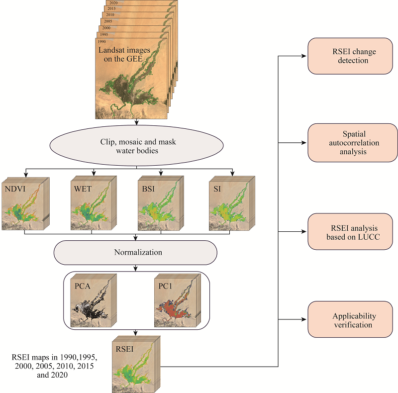
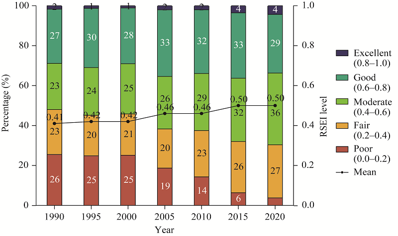
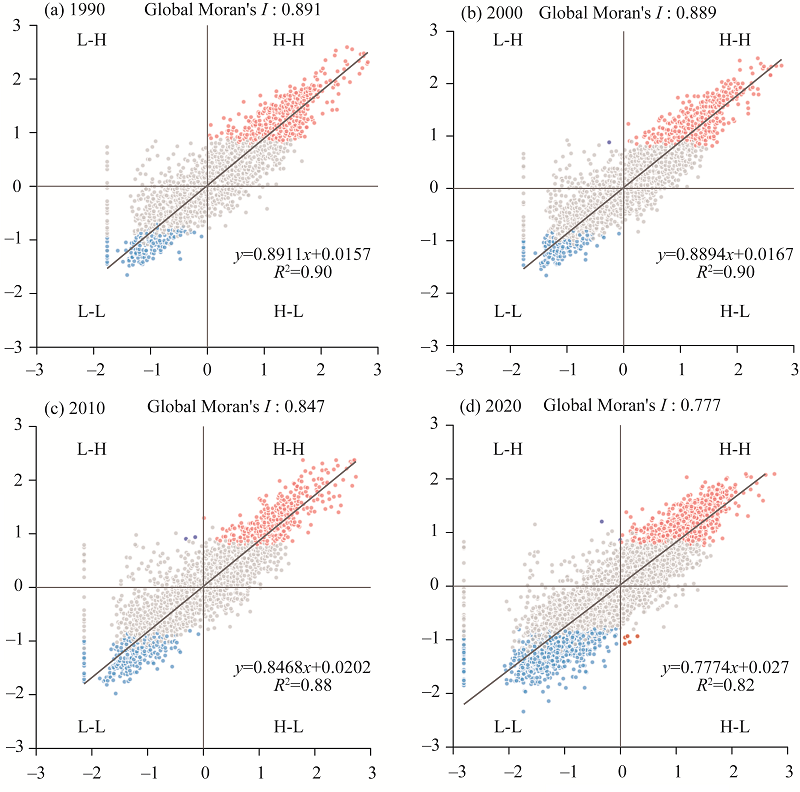
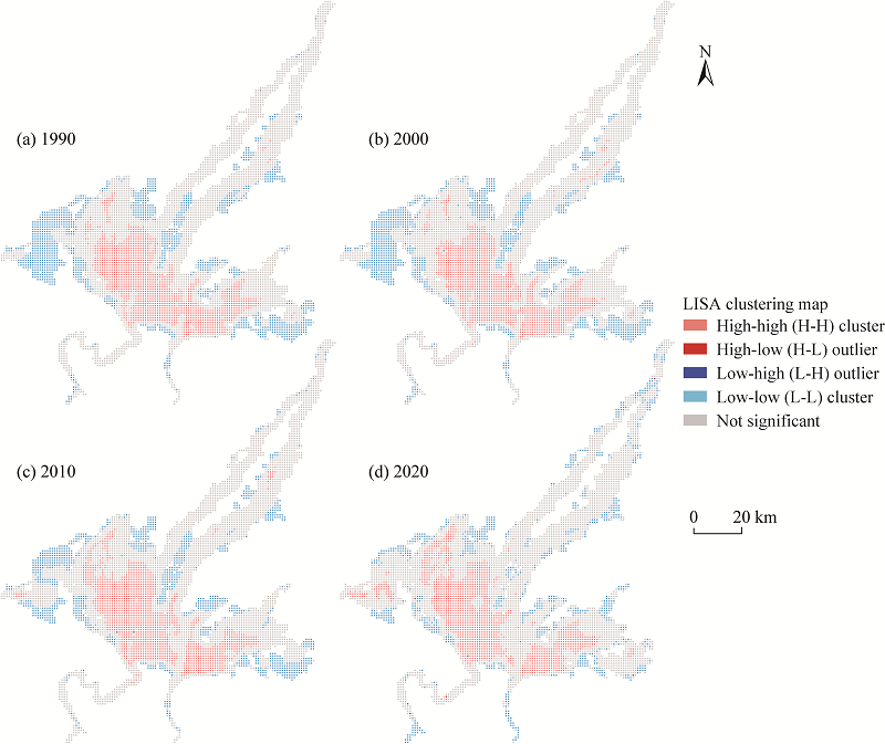
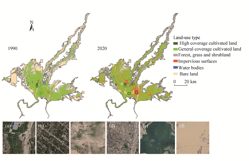
Abstract The rapid economic development that the Hotan Oasis in Xinjiang Uygur Autonomous Region, China has undergone in recent years may face some challenges in its ecological environment. Therefore, an analysis of the spatiotemporal changes in ecological environment of the Hotan Oasis is important for its sustainable development. First, we constructed an improved remote sensing-based ecological index (RSEI) in 1990, 1995, 2000, 2005, 2010, 2015 and 2020 on the Google Earth Engine (GEE) platform and implemented change detection for their spatial distribution. Second, we performed a spatial autocorrelation analysis on RSEI distribution map and used land-use and land-cover change (LUCC) data to analyze the reasons of RSEI changes. Finally, we investigated the applicability of improved RSEI to arid area. The results showed that mean of RSEI rose from 0.41 to 0.50, showing a slight upward trend. During the 30-a period, 2.66% of the regions improved significantly, 10.74% improved moderately and 32.21% improved slightly, respectively. The global Moran's I were 0.891, 0.889, 0.847 and 0.777 for 1990, 2000, 2010 and 2020, respectively, and the local indicators of spatial autocorrelation (LISA) distribution map showed that the high-high cluster was mainly distributed in the central part of the Hotan Oasis, and the low-low cluster was mainly distributed in the outer edge of the oasis. RSEI at the periphery of the oasis changes from low to high with time, with the fragmentation of RSEI distribution within the oasis increasing. Its distribution and changes are predominantly driven by anthropologic factors, including the expansion of artificial oasis into the desert, the replacement of desert ecosystems by farmland ecosystems, and the increase in the distribution of impervious surfaces. The improved RSEI can reflect the eco-environmental quality effectively of the oasis in arid area with relatively high applicability. The high efficiency exhibited with this approach makes it convenient for rapid, high frequency and macroscopic monitoring of eco-environmental quality in study area.
|
|
Received: 25 October 2021
Published: 31 March 2022
|
|
Corresponding Authors:
*Abudureheman HALIKE (E-mail: ah@xju.edu.cn)
|
|
|
| [1] |
Alexander C. 2020. Normalised difference spectral indices and urban land cover as indicators of land surface temperature (LST). International Journal of Applied Earth Observation and Geoinformation, 86: 102013, doi: 10.1016/j.jag.2019.102013.
doi: 10.1016/j.jag.2019.102013
|
|
|
| [2] |
Anselin L. 1995. Local indicators of spatial association-LISA. Geographical Analysis, 27(2): 93-115.
doi: 10.1111/gean.1995.27.issue-2
|
|
|
| [3] |
Baig M H A, Zhang L F, Shuai T, et al. 2014. Derivation of a tasselled cap transformation based on Landsat 8 at-satellite reflectance. Remote Sensing Letters, 5(5): 423-431.
doi: 10.1080/2150704X.2014.915434
|
|
|
| [4] |
Cao R, Chen Y, Shen M G, et al. 2018. A simple method to improve the quality of NDVI time-series data by integrating spatiotemporal information with the Savitzky-Golay filter. Remote Sensing of Environment, 217: 244-257.
doi: 10.1016/j.rse.2018.08.022
|
|
|
| [5] |
Chen J, Shen M G, Zhu X L, et al. 2009. Indicator of flower status derived from in situ hyperspectral measurement in an alpine meadow on the Tibetan Plateau. Ecological Indicators, 9(4): 818-823.
doi: 10.1016/j.ecolind.2008.09.009
|
|
|
| [6] |
Chen M X, Ye C, Lu D D, et al. 2019. Cognition and construction of the theoretical connotations of new urbanization with Chinese characteristics. Journal of Geographical Sciences, 29(10): 1681-1698.
doi: 10.1007/s11442-019-1685-z
|
|
|
| [7] |
Chu H S, Venevsky S, Wu C, et al. 2019. NDVI-based vegetation dynamics and its response to climate changes at Amur-Heilongjiang River Basin from 1982 to 2015. Science of the Total Environment, 650: 2051-2062.
doi: 10.1016/j.scitotenv.2018.09.115
|
|
|
| [8] |
Cook M, Schott J R, Mandel J, et al. 2014. Development of an operational calibration methodology for the Landsat thermal data archive and initial testing of the atmospheric compensation component of a land surface temperature (LST) product from the archive. Remote Sensing, 6(11): 11244-11266.
doi: 10.3390/rs61111244
|
|
|
| [9] |
Deng X Z, Huang J K, Rozelle S, et al. 2015. Impact of urbanization on cultivated land changes in China. Land Use Policy, 45: 1-7.
doi: 10.1016/j.landusepol.2015.01.007
|
|
|
| [10] |
Ding Y, Abdirahman H, Chen X Y, et al. 2020. Spatial-temporal changes in vegetation characteristics and climate in Hotan Prefecture. Acta Ecologica Sinica, 40(4): 1258-1268. (in Chinese)
|
|
|
| [11] |
Dong D W, Abdirahman H, Wang D D, et al. 2019. Spatio-temporal variations in vegetation cover in Hotan Oasis from 1994 to 2016. Acta Ecologica Sinica, 39(10): 3710-3719. (in Chinese)
|
|
|
| [12] |
Fang H L, Zhang Y G, Wei S S, et al. 2019. Validation of global moderate resolution leaf area index (LAI) products over croplands in northeastern China. Remote Sensing of Environment, 233: 111377, doi: 10.1016/j.rse.2019.111377.
doi: 10.1016/j.rse.2019.111377
|
|
|
| [13] |
Feidas H, Karagiannidis A, Keppas S, et al. 2014. Modeling and mapping temperature and precipitation climate data in Greece using topographical and geographical parameters. Theoretical and Applied Climatology, 118(1): 133-146.
doi: 10.1007/s00704-013-1052-4
|
|
|
| [14] |
Fung T, Siu W. 2000. Environmental quality and its changes, an analysis using NDVI. International Journal of Remote Sensing, 21(5): 1011-1024.
doi: 10.1080/014311600210407
|
|
|
| [15] |
Getis A. 2007. Reflections on spatial autocorrelation. Regional Science and Urban Economics, 37(4): 491-496.
doi: 10.1016/j.regsciurbeco.2007.04.005
|
|
|
| [16] |
Guo H, Bao A M, Liu AT, et al. 2019. Determining variable weights for an Optimal Scaled Drought Condition Index (OSDCI): Evaluation in Central Asia. Remote Sensing of Environment, 231: 111220, doi: 10.1016/j.rse.2019.111220.
doi: 10.1016/j.rse.2019.111220
|
|
|
| [17] |
Guo H W, Ling H B, Xu H L, et al. 2016. Study of suitable oasis scales based on water resource availability in an arid region of China: a case study of Hotan River Basin. Environmental Earth Sciences, 75(11): 1-14.
doi: 10.1007/s12665-015-4873-x
|
|
|
| [18] |
Guo Y H, Abdirahman H, Wei T B, et al. 2021. The ecosystem service value evaluation of Hotan area based on land use changes. Acta Ecologica Sinica, 41(16): 6363-6372. (in Chinese)
|
|
|
| [19] |
Hao L N, Su X L, Singh V P, et al. 2019. Suitable oasis and cultivated land scales in arid regions based on ecological health. Ecological Indicators, 102: 33-42.
doi: 10.1016/j.ecolind.2019.01.053
|
|
|
| [20] |
Hassan M A, Yang M J, Rasheed A, et al. 2019. A rapid monitoring of NDVI across the wheat growth cycle for grain yield prediction using a multi-spectral UAV platform. Plant Science, 282: 95-103.
doi: 10.1016/j.plantsci.2018.10.022
|
|
|
| [21] |
Huang C, Wylie B, Yang L, et al. 2002. Derivation of a tasselled cap transformation based on Landsat 7 at-satellite reflectance. Remote Sensing Letters, 23(8): 1741-1748.
|
|
|
| [22] |
Jia H W, Yan C Z, Xing X G, et al. 2021. Evaluation of ecological environment in the Dulan County based on the modified remote sensing ecological index model. Journal of Desert Research, 41(2): 181-190. (in Chinese)
|
|
|
| [23] |
Jiang C L, Wu L, Liu D, et al. 2019. Dynamic monitoring of eco-environmental quality in arid desert area by remote sensing: Taking the Gurbantunggut Desert China as an example. Chinese Journal of Applied Ecology, 30(3): 877-883. (in Chinese)
|
|
|
| [24] |
Jiang L L, Jiapaer G, Bao A M, et al. 2019. Assessing land degradation and quantifying its drivers in the Amudarya River delta. Ecological Indicators, 107: 105595, doi: 10.1016/j.ecolind.2019.105595.
doi: 10.1016/j.ecolind.2019.105595
|
|
|
| [25] |
Jing Y Q, Zhang F, He Y F, et al. 2020. Assessment of spatial and temporal variation of ecological environment quality in Ebinur Lake Wetland National Nature Reserve, Xinjiang, China. Ecological Indicators, 110: 105874, doi: 10.1016/j.ecolind.2019.105874.
doi: 10.1016/j.ecolind.2019.105874
|
|
|
| [26] |
Joshi P P, Wynne R H, Thomas V A, et al. 2019. Cloud detection algorithm using SVM with SWIR2 and tasseled cap applied to Landsat 8. International Journal of Applied Earth Observation and Geoinformation, 82: 101898, doi: 10.1016/j.jag.2019.101898.
doi: 10.1016/j.jag.2019.101898
|
|
|
| [27] |
Kganyago M, Mhangara P, Alexandridis T, et al. 2020. Validation of sentinel-2 leaf area index (LAI) product derived from SNAP toolbox and its comparison with global LAI products in an African semi-arid agricultural landscape. Remote Sensing Letters, 11(10): 883-892.
doi: 10.1080/2150704X.2020.1767823
|
|
|
| [28] |
Khan N M, Rastoskuev V V, Sato Y, et al. 2005. Assessment of hydrosaline land degradation by using a simple approach of remote sensing indicators. Agricultural Water Management, 77(1-3): 96-109.
doi: 10.1016/j.agwat.2004.09.038
|
|
|
| [29] |
Legendre P. 1993. Spatial autocorrelation: trouble or new paradigm?. Ecology, 74(6): 1659-1673.
doi: 10.2307/1939924
|
|
|
| [30] |
Li R H, Chen N C, Zhang X, et al. 2020. Quantitative analysis of agricultural drought propagation process in the Yangtze River Basin by using cross wavelet analysis and spatial autocorrelation. Agricultural and Forest Meteorology, 280: 107809, doi: 10.1016/j.agrformet.2019.107809.
doi: 10.1016/j.agrformet.2019.107809
|
|
|
| [31] |
Li Z Y, Han Y, Hao T Y. 2020. Assessing the consistency of remotely sensed multiple drought indices for monitoring drought phenomena in continental China. IEEE Transactions on Geoscience and Remote Sensing, 58(8): 5490-5502.
doi: 10.1109/TGRS.36
|
|
|
| [32] |
Liu C, Yang M H, Hou Y T, et al. 2021. Spatiotemporal evolution of island ecological quality under different urban densities: A comparative analysis of Xiamen and Kinmen Islands, southeast China. Ecological Indicators, 124: 107438, doi: 10.1016/j.ecolind.2021.107438.
doi: 10.1016/j.ecolind.2021.107438
|
|
|
| [33] |
Liu Y, Xue J, Gui D W, et al. 2018. Agricultural oasis expansion and its impact on oasis landscape patterns in the southern margin of Tarim Basin, Northwest China. Sustainability, 10(6): 1957.
doi: 10.3390/su10061957
|
|
|
| [34] |
Mildrexler D J, Zhao M S, Running S W. 2009. Testing a MODIS global disturbance index across North America. Remote Sensing of Environment, 113(10): 2103-2117.
doi: 10.1016/j.rse.2009.05.016
|
|
|
| [35] |
Moran P A P. 1948. The interpretation of statistical maps. Journal of the Royal Statistical Society: Series B (Methodological), 10(2): 243-251.
|
|
|
| [36] |
Mutanga O, Kumar L. 2019. Google earth engine applications. Remote Sensing, 11(5): 591.
doi: 10.3390/rs11050591
|
|
|
| [37] |
Pekel J F, Cottam A, Gorelick N, et al. 2016. High-resolution mapping of global surface water and its long-term changes. Nature, 540(7633): 418-422.
doi: 10.1038/nature20584
|
|
|
| [38] |
Rhee J, Im J, Carbone G J. 2010. Monitoring agricultural drought for arid and humid regions using multi-sensor remote sensing data. Remote Sensing of Environment, 114(12): 2875-2887.
doi: 10.1016/j.rse.2010.07.005
|
|
|
| [39] |
Sokal R R, Oden N L. 1978. Spatial autocorrelation in biology: Methodology. Biological Journal of the Linnean Society, 10(2): 199-228.
doi: 10.1111/bij.1978.10.issue-2
|
|
|
| [40] |
Wang J, Ma J L, Xie F F, et al. 2020. Improvement of remote sensing ecological index in arid regions: Taking Ulan Buh Desert as an example. Chinese Journal of Applied Ecology, 31(11): 3795-3804. (in Chinese)
|
|
|
| [41] |
Wang J, Liu D W, Ma J L, et al. 2021. Development of a large-scale remote sensing ecological index in arid areas and its application in the Aral Sea Basin. Journal of Arid Land, 13(1): 40-55.
doi: 10.1007/s40333-021-0052-y
|
|
|
| [42] |
Wang L C, Jiao L, Lai F B, et al. 2019. Evaluation of ecological changes based on a remote sensing ecological index in a Manas Lake wetland. Acta Ecologica Sinica, 39(8): 2963-2972. (in Chinese)
|
|
|
| [43] |
Wang L P, Wang S F, Zhang L D, et al. 2020. Assessing the spatial pattern of irrigation demand under climate change in arid area. ISPRS International Journal of Geo-Information, 9(9): 506.
doi: 10.3390/ijgi9090506
|
|
|
| [44] |
Wang Y G. 2021. Evaluation of lake wetland ecotourism resources based on remote sensing ecological index. Arabian Journal of Geosciences, 14(7): 1-8.
doi: 10.1007/s12517-020-06304-8
|
|
|
| [45] |
Wang Z X, Liu C, Alfredo H. 2003. From AVHRR-NDVI to MODIS-EVI: Advances in vegetation index research. Acta Ecologica Sinica, 23(5): 979-987. (in Chinese)
|
|
|
| [46] |
Whitney K, Scudiero E, El-Askary H M, et al. 2018. Validating the use of MODIS time series for salinity assessment over agricultural soils in California, USA. Ecological Indicators, 93: 889-898.
doi: 10.1016/j.ecolind.2018.05.069
|
|
|
| [47] |
Xiong Y, Xu W H, Lu N, et al. 2021. Assessment of spatial-temporal changes of ecological environment quality based on RSEI and GEE: A case study in Erhai Lake Basin, Yunnan Province, China. Ecological Indicators, 125: 107518, doi: 10.1016/j.ecolind.2021.107518.
doi: 10.1016/j.ecolind.2021.107518
|
|
|
| [48] |
Xu H Q. 2005. A study on information extraction of water body with the modified normalized difference water index (MNDWI). Journal of Remote Sensing, 9(5): 589-595. (in Chinese)
|
|
|
| [49] |
Xu H Q. 2013. A remote sensing urban ecological index and its application. Acta Ecologica Sinica, 33(24): 7853-7862. (in Chinese)
|
|
|
| [50] |
Xu H Q, Wang M Y, Shi T T, et al. 2018. Prediction of ecological effects of potential population and impervious surface increases using a remote sensing based ecological index (RSEI). Ecological Indicators, 93: 730-740.
doi: 10.1016/j.ecolind.2018.05.055
|
|
|
| [51] |
Xu H Q, Wang Y F, Guan H, et al. 2019. Detecting ecological changes with a remote sensing based ecological index (RSEI) produced time series and change vector analysis. Remote Sensing, 11(20): 2345.
doi: 10.3390/rs11202345
|
|
|
| [52] |
Xue D P, Xue J, Dai H, et al. 2021. Analysis of spatial and temporal pattern changes and driving factors of Hotan Oasis. Journal of Desert Research, 41(4): 59-69. (in Chinese)
|
|
|
| [53] |
Xue J, Su B F. 2017. Significant remote sensing vegetation indices: A review of developments and applications. Journal of Sensors, 2017: 1-17, doi: 10.1155/2017/1353691.
|
|
|
| [54] |
Yang Q Q, Xu G L, Li A J, et al. 2021. Evaluation and trade-off of ecosystem services in the Qingyijiang River Basin. Acta Ecologica Sinica, 41(23): 9315-9327. (in Chinese)
|
|
|
| [55] |
Yu G M, Zhang S, Yu Q W, et al. 2014. Assessing ecological security at the watershed scale based on RS/GIS: A case study from the Hanjiang River Basin. Stochastic Environmental Research and Risk Assessment, 28(2): 307-318.
doi: 10.1007/s00477-013-0750-x
|
|
|
| [56] |
Yu R H, Liu T X, Xu Y P, et al. 2010. Analysis of salinization dynamics by remote sensing in Hetao Irrigation District of North China. Agricultural Water Management, 97(12): 1952-1960.
doi: 10.1016/j.agwat.2010.03.009
|
|
|
| [57] |
Yu T, Jiapaer G, Bao A M, et al. 2021. Using synthetic remote sensing indicators to monitor the land degradation in a salinized area. Remote Sensing, 13(15): 2581, doi: 10.3390/rs13152851.
doi: 10.3390/rs13132581
|
|
|
| [58] |
Zhang T Y, Wang L, Wang H, et al. 2017. Assessment of soil salinization ecological environment change in the Manas river basin using remote sensing technology. Acta Ecologica Sinica, 37(9): 3009-3018. (in Chinese)
|
|
|
| [59] |
Zhao G, Gao H L, Cai X M, 2020. Estimating lake temperature profile and evaporation losses by leveraging MODIS LST data. Remote Sensing of Environment, 251: 112104, doi: 10.1016/j.rse.2020.112104.
doi: 10.1016/j.rse.2020.112104
|
|
|
| [60] |
Zheng Z H, Wu Z F, Chen Y B, et al. 2020. Exploration of eco-environment and urbanization changes in coastal zones: A case study in China over the past 20 years. Ecological Indicators, 119: 106847, doi: 10.1016/j.ecolind.2020.106847.
|
|
|
| [61] |
Zhu J W, Xie X T, Li X H. 2017. A solution to the problem of ecological environmental carrying capacity evaluation: A case study of Henan Province. Acta Ecologica Sinica, 37(21): 7039-7047. (in Chinese)
|
|
|
|
Viewed |
|
|
|
Full text
|
|
|
|
|
Abstract
|
|
|
|
|
Cited |
|
|
|
|
| |
Shared |
|
|
|
|
| |
Discussed |
|
|
|
|