| Research article |
|


|
|
|
| Spatiotemporal variation in vegetation net primary productivity and its relationship with meteorological factors in the Tarim River Basin of China from 2001 to 2020 based on the Google Earth Engine |
CHEN Limei1,2,3, Abudureheman HALIKE1,2,3,*( ), YAO Kaixuan1,2, WEI Qianqian1,3 ), YAO Kaixuan1,2, WEI Qianqian1,3 |
1College of Geography and Remote Sensing Sciences, Xinjiang University, Urumqi 830017, China
2Xinjiang Key Laboratory of Oasis Ecology, Xinjiang University, Urumqi 830017, China
3Key Laboratory of Smart City and Environment Modelling of Higher Education Institute, Xinjiang University, Urumqi 830017, China |
|
|
|
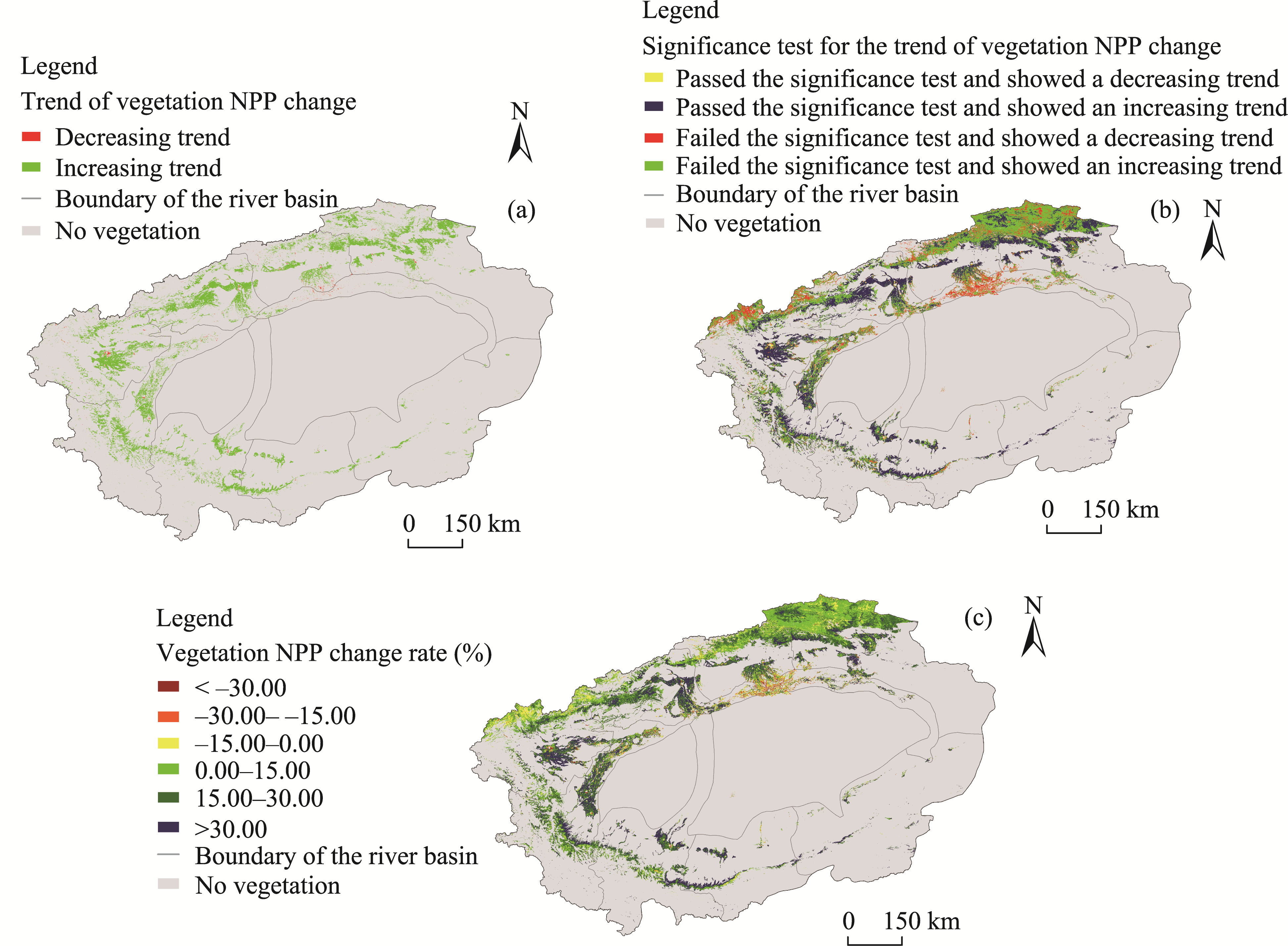
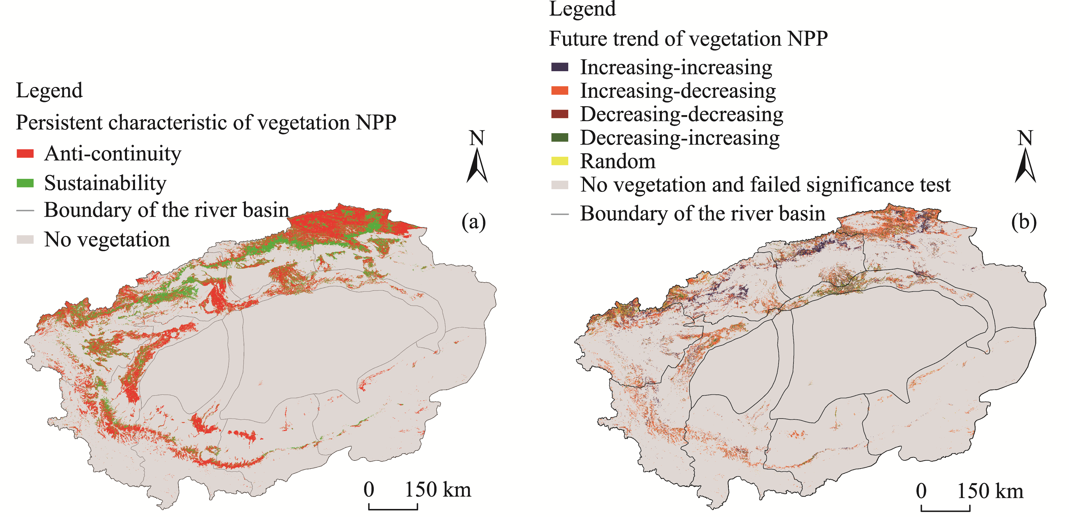
Abstract Vegetation growth status is an important indicator of ecological security. The Tarim River Basin is located in the inland arid region of Northwest China and has a highly fragile ecological environment. Assessing the vegetation net primary productivity (NPP) of the Tarim River Basin can provide insights into the vegetation growth variations in the region. Therefore, based on the Google Earth Engine (GEE) cloud platform, we studied the spatiotemporal variation of vegetation NPP in the Tarim River Basin (except for the eastern Gobi and Kumutag deserts) from 2001 to 2020 and analyzed the correlations between vegetation NPP and meteorological factors (air temperature and precipitation) using the Sen slope estimation method, coefficient of variation, and rescaled range analysis method. In terms of temporal characteristics, vegetation NPP in the Tarim River Basin showed an overall fluctuating upward trend from 2001 to 2020, with the smallest value of 118.99 g C/(m2?a) in 2001 and the largest value of 155.07 g C/(m2?a) in 2017. Regarding the spatial characteristics, vegetation NPP in the Tarim River Basin showed a downward trend from northwest to southeast along the outer edge of the study area. The annual average value of vegetation NPP was 133.35 g C/(m2?a), and the area with annual average vegetation NPP values greater than 100.00 g C/(m2?a) was 82,638.75 km2, accounting for 57.76% of the basin. The future trend of vegetation NPP was dominated by anti-continuity characteristic; the percentage of the area with anti-continuity characteristic was 63.57%. The area with a significant positive correlation between vegetation NPP and air temperature accounted for 53.74% of the regions that passed the significance test, while the area with a significant positive correlation between vegetation NPP and precipitation occupied 98.68% of the regions that passed the significance test. Hence, the effect of precipitation on vegetation NPP was greater than that of air temperature. The results of this study improve the understanding on the spatiotemporal variation of vegetation NPP in the Tarim River Basin and the impact of meteorological factors on vegetation NPP.
|
|
Received: 28 February 2022
Published: 31 December 2022
|
|
Corresponding Authors:
*Abudureheman HALIKE (E-mail: ah@xju.edu.cn)
|
|
|
| [1] |
Amani M, Ghorbanian A, Ahmadi S A, et al. 2020. Google Earth Engine cloud computing platform for remote sensing big data applications: a comprehensive review. IEEE Journal of Selected Topics in Applied Earth Observations and Remote Sensing, 13: 5326-5350.
doi: 10.1109/JSTARS.2020.3021052
|
|
|
| [2] |
Bai Y F, Xu H L, Wang X Y, et al. 2015. A primary investigation on net primary productivity model of herbaceous plant in the lower reaches of Tarim River, Xinjiang. Journal of Arid Land Resources and Environment, 29(9): 92-96. (in Chinese)
|
|
|
| [3] |
Bondeau A, Kicklighter D W, Kaduk J. 1999. Comparing global models of terrestrial net primary productivity (NPP): Importance of vegetation structure on seasonal NPP estimates. Global Change Biology, 5(Suppl. 1): 35-45.
doi: 10.1046/j.1365-2486.1999.00005.x
|
|
|
| [4] |
Cao B, Zhang B, Ma B, et al. 2018. Spatial and temporal variations of NDVI in Gansu, China from 2000 to 2014. Journal of Desert Research, 38(2): 418-427. (in Chinese)
|
|
|
| [5] |
Choudhury B J. 2000. Carbon use efficiency, and net primary productivity of terrestrial vegetation. Advances in Space Research, 26(7): 1105-1108.
doi: 10.1016/S0273-1177(99)01126-6
|
|
|
| [6] |
Chu Z, Xu C C, Luo Y X, et al. 2021. Land use simulation and ecological benefit evaluation in the Tarim River basin based on ecological protection red line management. Acta Ecologica Sinica, 41(18):7380- 7392. (in Chinese)
|
|
|
| [7] |
Cui B C, Zheng J H, Tuerxun H, et al. 2020. Spatial-temporal Characteristics of grassland net primary product (NPP) in the Tarim River Basin. Acta Prataculturae Sinica, 29(6): 1-13. (in Chinese)
|
|
|
| [8] |
Dai S P, Zhang B, Wang H J, et al. 2010. Analysis on the spatio-temporal variation of grassland cover using SPOT NDVI in Qilian Mountains. Progress in Geography, 29(9): 1075-1080. (in Chinese)
doi: 10.11820/dlkxjz.2010.09.008
|
|
|
| [9] |
Dawood M, Rahman A, Ullah S, et al. 2018. Spatio-temporal analysis of temperature variability, trend, and magnitude in the Hindu Kush region using Monte Carlo and Sen's slope approaches. Arabian Journal of Geosciences, 11(16): 1-15.
doi: 10.1007/s12517-017-3236-1
|
|
|
| [10] |
Deng M J. 2009. Theory and Practice of Water Management in Tarim River, China. Beijing: Science Press,1-3. (in Chinese)
|
|
|
| [11] |
Dong J, Xiao X, Menarguez M A, et al. 2016. Mapping paddy rice planting area in northeastern Asia with Landsat 8 images, phenology-based algorithm and Google Earth Engine. Remote Sensing of Environment, 18(5): 142-154.
|
|
|
| [12] |
Gao J. 2019. Temporal and spatial distribution characteristics and influencing factors of vegetation net primary productivity in the northern slope of Tianshan Mountains. MSc Thesis. Shihezi: Shihezi University, 11-13. (in Chinese)
|
|
|
| [13] |
Gorelick N, Hancher M, Dixon M, et al. 2017. Google Earth Engine: Planetary-scale geospatial analysis for everyone. Remote Sensing of Environment, 202: 18-27.
doi: 10.1016/j.rse.2017.06.031
|
|
|
| [14] |
Gu L, Yue C R, Zhang G F, et al. 2021. Temporal and spatial analysis of vegetation NPP in the Greater Mekong Subregion based on Google Earth Engine platform from 2001 to 2019. Journal of West China Forestry Science, 50(2): 132-139. (in Chinese)
|
|
|
| [15] |
Guo L F, Lai Q, Yin B L, et al. 2017. Spatial temporal changes of net primary production of river wetland and its driving factors in Hulun Buir Sandy Land in 2000-2014. Research of Soil and Water Conservation, 24(6): 267-272. (in Chinese)
|
|
|
| [16] |
Huang H B, Chen Y L, Clinton N, et al. 2017. Mapping major land cover dynamics in Beijing using all Landsat images in Google Earth Engine. Remote Sensing of Environment, 202: 166-176.
doi: 10.1016/j.rse.2017.02.021
|
|
|
| [17] |
Huang Y Y. 2020. Spatial-temporal distribution and driving factors of vegetation net primary productivity in North China Plain from 2000 to 2018. MSc Thesis. Lanzhou: Northwest Normal University, 29-31. (in Chinese)
|
|
|
| [18] |
Jassal R S, Black T A, Cai T, et al. 2007. Components of ecosystem respiration and an estimate of net primary productivity of an intermediate-aged Douglas-fir stand. Agricultural and Forest Meteorology, 144(1-2): 44-57.
doi: 10.1016/j.agrformet.2007.01.011
|
|
|
| [19] |
Jiang P, Ding W G, Xiao J, et al. 2021. Altitudinal difference of vegetation NPP and its response to climate change in Xinjiang. Arid Land Geogeaphy, 44(3): 849-857. (in Chinese)
|
|
|
| [20] |
Jiao W, Chen Y N, Li Z. 2017. Remote sensing estimation and the reasons for temporal-spatial differences of vegetation net primary productivity in arid region of Northwest China. Chinese Journal of Ecology, 36(1): 181-189. (in Chinese)
|
|
|
| [21] |
Jiao W, Chen Y N, Li W H, et al. 2018. Estimation of net primary productivity and its driving factors in the Ili River Valley, China. Journal of Arid Land, 10(5): 781-793.
doi: 10.1007/s40333-018-0022-1
|
|
|
| [22] |
Kendall M G. 1948. Rank Correlation Methods. London: Charles Griffin Press,12-17.
|
|
|
| [23] |
Kumar L, Mutanga O. 2018. Google Earth Engine applications since inception: Usage, trends, and potential. Remote Sensing, 10(10): 1509, doi: 10.3390/rs10101509.
doi: 10.3390/rs10101509
|
|
|
| [24] |
Li L. 2019. Influence of climate change and human activities on vegetation NPP changes in Northwest China. MSc Thesis. Xi'an: Shaanxi Normal University. (in Chinese)
|
|
|
| [25] |
Li S, Yan J, Wan J. 2012. The spatial-temporal changes of vegetation restoration on Loess Plateau in Shaanxi-Gansu-Ningxia Region. Acta Geographica Sinica, 67(7): 960-970. (in Chinese)
doi: 10.11821/xb201207009
|
|
|
| [26] |
Li S B, He S Y. 2022. The variation of net primary productivity and underlying mechanisms vary under different drought stress in Central Asia from 1990 to 2020. Agricultural and Forest Meteorology, 314: 108767, doi: 10.1016/j.agrformet.2021.108767.
doi: 10.1016/j.agrformet.2021.108767
|
|
|
| [27] |
Lobell D B, Thau D, Seifert C, et al. 2015. A scalable satellite-based crop yield mapper. Remote Sensing of Environment, 164: 324-333.
doi: 10.1016/j.rse.2015.04.021
|
|
|
| [28] |
Merchant K. 2021. Brief discussion on ecological restoration and management in the middle reaches of the main stream of the Tarim River Basin. Engineering and Construction, 35(1): 15-16. (in Chinese)
|
|
|
| [29] |
Michaletz S T, Cheng D, Kerkhoff A J, et al. 2014. Convergence of terrestrial plant production across global climate gradients. Nature, 512(1): 39-43.
doi: 10.1038/nature13470
|
|
|
| [30] |
Mutanga O, Kumar L. 2019. Google Earth Engine Applications. Remote Sensing, 11(5): 11-14.
doi: 10.3390/rs11010011
|
|
|
| [31] |
Pan J H, Huang K J, Li Z. 2018. Spatio-temporal variation in vegetation net primary productivity and its relationship with climatic factors in the Shule River basin from 2001 to 2010. Human and Ecological Risk Assessment, 24(3): 797-818. (in Chinese)
doi: 10.1080/10807039.2017.1400373
|
|
|
| [32] |
Pekel J F, Cottam A, Gorelick N, et al. 2016. High-resolution mapping of global surface water and its long-term changes. Nature, 540(7633): 418-422.
doi: 10.1038/nature20584
|
|
|
| [33] |
Piao S L, Fang J Y, Chen A P. 2003. Seasonal dynamics of terrestrial net primary production in response to climate changes in China. Acta Botanica Sinica, 45: 269-275.
|
|
|
| [34] |
Qin J X, Hao X M, Zhang Y, et al. 2020. Effects of climate change and human activities on vegetation productivity in arid areas. Arid Land Geography, 43(1): 117-125. (in Chinese)
|
|
|
| [35] |
Sen P K. 1968. Estimates of the regression coefficient based on Kendall's Tau. Journal of the American Statistical Association, 63(324): 137-139.
|
|
|
| [36] |
Tamiminia H, Salehi B, Mahdianpari M, et al. 2020. Google Earth Engine for geo-big data applications: A meta-analysis and systematic review. ISPRS Journal of Photogrammetry and Remote Sensing, 164: 152-170.
doi: 10.1016/j.isprsjprs.2020.04.001
|
|
|
| [37] |
Tong L J, Liu Y Y, Wang Q. 2019. Patial and temporal dynamics of net primary productivity and its driving factors in Northwest China. Research of Soil and Water Conservation, 26(4): 367-374. (in Chinese)
|
|
|
| [38] |
Tong S Q, Zhang J Q, Bao Y H, et al. 2018. Analyzing vegetation dynamic trend on the Mongolian Plateau based on the Hurst exponent and influencing factors from 1982-2013. Journal of Geographical Sciences, 28(5): 595-610.
doi: 10.1007/s11442-018-1493-x
|
|
|
| [39] |
Turner D P, Ritts W D, Cohen W B, et al. 2006. Evaluation of MODIS NPP and GPP products across multiple biomes. Remote Sensing of Environment, 102(3-4): 282-292.
doi: 10.1016/j.rse.2006.02.017
|
|
|
| [40] |
Wang J J, Li B X, Gao Z Y, et al. 2021. Trend and attribution analysis of extreme wave intensity in the China Sea. Chinese Science Bulletin, 66(19): 2455-2467. (in Chinese)
|
|
|
| [41] |
Wang L, Liu P, Wang Y. 2015. Spatial and temporal variations of NDVI and its influencing factors in Qaidam Basin in the last 14 years. Chinese Journal of Ecology, 34(6): 1713-1722. (in Chinese)
|
|
|
| [42] |
Wang Y D, Li Z W, Zeng C, et al. 2020. An urban water extraction method combining deep learning and Google Earth Engine. IEEE Journal of Selected Topics in Applied Earth Observations and Remote Sensing, 13: 768-781.
|
|
|
| [43] |
Xiong Y F. 2018. Research on water resources management in Tarim River Basin. Journal of Green Science and Technology, 42(14): 98-100. (in Chinese)
|
|
|
| [44] |
Ye M, Xu H L, Song Y D, et al. 2006. Some problems and challenges about water resources utilization in the Tarim River Basin. Arid Zone Research, 23(3): 388-392. (in Chinese)
|
|
|
| [45] |
Yin S Y, Wu W J, Zhao X J, et al. 2020. Understanding spatiotemporal patterns of global forest NPP using a data-driven method based on GEE. PloS ONE, 15(3): e0230098, doi: 10.1371/journal.pone.0230098
doi: 10.1371/journal.pone.0230098
|
|
|
| [46] |
Yuan L H, Jiang W G, Shen W M, et al. 2013. The spatio-temporal variations of vegetation cover in the Yellow River Basin from 2000 to 2010. Acta Ecologica Sinica, 33(24): 7798-7806. (in Chinese)
|
|
|
| [47] |
Zhang J X. 2021. The spatial and temporal distribution pattern of vegetation net primary productivity in Xinjiang and its climate and anthropogenic contribution. MSc Thesis. Urumqi: Xinjiang University. (in Chinese)
|
|
|
| [48] |
Zhang X L, Wang Y C, Xiao W H, et al. 2018. Responses of net primary productivity of natural vegetation to climate change in the Shiyang River Basin. Chinese Journal of Ecology, 37(10): 3110-3118. (in Chinese)
|
|
|
| [49] |
Zhang Y, Hu Q H, Zou F Z. 2021. Spatio-temporal changes of vegetation net primary productivity and its driving factors on the Qinghai-Tibetan plateau from 2001 to 2017. Remote Sensing, 13(8): 1566, doi: 10.3390/rs13081566.
doi: 10.3390/rs13081566
|
|
|
| [50] |
Zhao P, Yu R D, Chen T, et al. 2019. Variation of vegetation net primary productivity in Bortala-Jinghe River Basin of Xinjiang and its relationship with main climatic factors. Journal of Plant Resources and Environment, 28(1): 79-84. (in Chinese)
|
|
|
| [51] |
Zhao P, Wang D J, He S T, et al. 2020. Driving forces of NPP change in debris flow prone area: A case study of a typical region in SW China. Ecological Indicators, 119: 106811, doi: 10.1016/j.ecolind.2020.106811.
doi: 10.1016/j.ecolind.2020.106811
|
|
|
| [52] |
Zhao Y X, Xie P, Sang Y F, et al. 2017. Principle of correlation coefficient-based classification of hydrological trend and its verification. Chinese Science Bulletin, 62(26): 3089-3097. (in Chinese)
|
|
|
| [53] |
Zhu H, Ji C C. 2011. Fractal Theory and Its Applications. Beijing: Science Press,2-6. (in Chinese)
|
|
|
| [54] |
Zhu Y Y. 2019. Remote sensing estimation of vegetation net primary productivity and its response to climate change in the Yellow River Basin from 1992 to 2015. MSc Thesis. Xi'an: Chang'an University, 35-36. (in Chinese)
|
|
|
| [55] |
Zhu Y Y, Han L, Zhao Y H, et al. 2019. Simulation and spatio-temporal pattern of vegetation NPP in northwest China. Chinese Journal of Ecology, 38(6): 1861-1871. (in Chinese)
|
|
|
|
Viewed |
|
|
|
Full text
|
|
|
|
|
Abstract
|
|
|
|
|
Cited |
|
|
|
|
| |
Shared |
|
|
|
|
| |
Discussed |
|
|
|
|