| Research article |
|


|
|
|
| Assessment of ecological quality in Northwest China (2000-2020) using the Google Earth Engine platform: Climate factors and land use/land cover contribute to ecological quality |
WANG Jinjie1,2,3, DING Jianli1,2,3,*( ), GE Xiangyu1,2,3, QIN Shaofeng1,2,3, ZHANG Zhe1,2,3 ), GE Xiangyu1,2,3, QIN Shaofeng1,2,3, ZHANG Zhe1,2,3 |
1College of Geography and Remote Sensing Science, Xinjiang University, Urumqi 800046, China
2Xinjiang Key Laboratory of Oasis Ecology, Xinjiang University, Urumqi 830046, China
3Key Laboratory of Smart City and Environment Modelling of Higher Education Institute, Xinjiang University, Urumqi 830046, China |
|
|
|
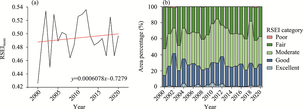
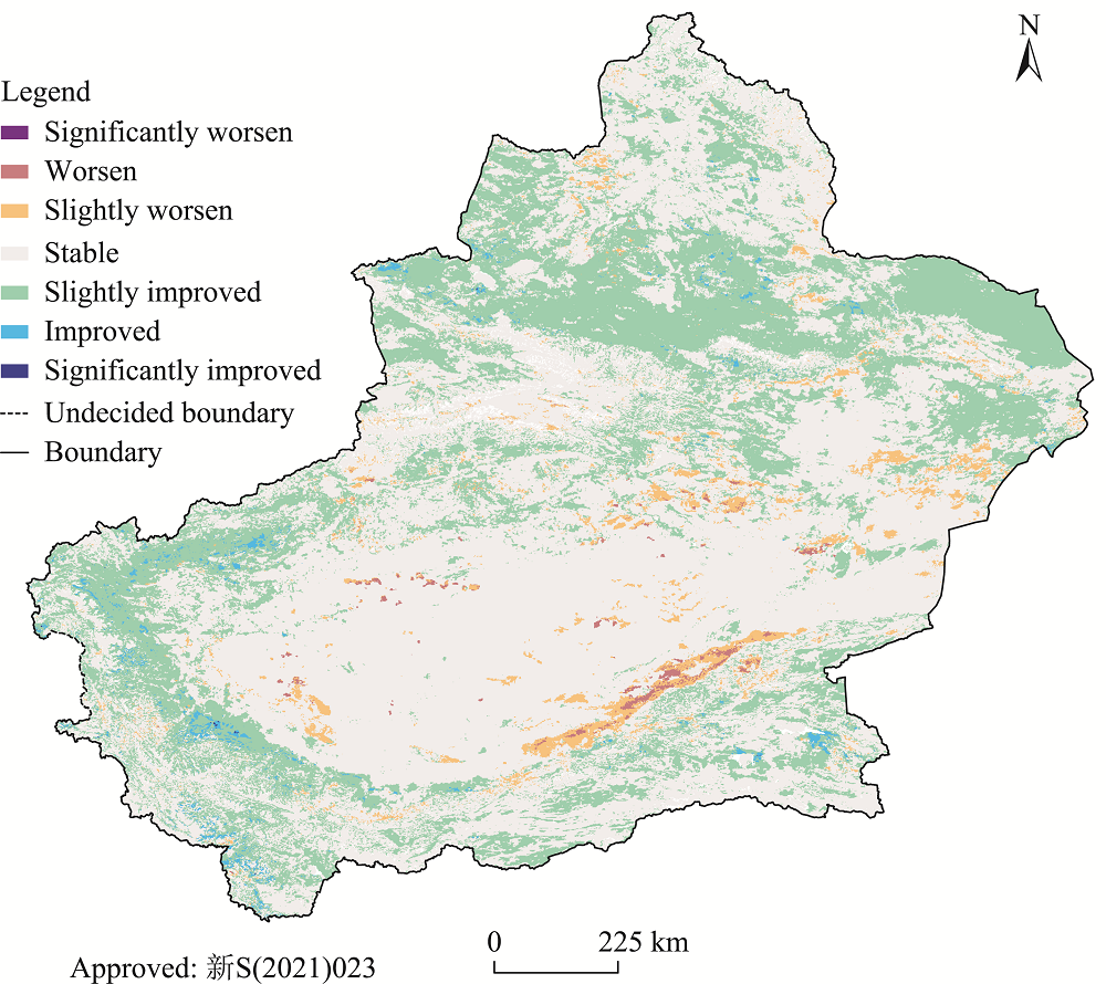
Abstract The ecological quality of inland areas is an important aspect of the United Nations Sustainable Development Goals (UN SDGs). The ecological environment of Northwest China is vulnerable to changes in climate and land use/land cover, and the changes in ecological quality in this arid region over the last two decades are not well understood. This makes it more difficult to advance the UN SDGs and develop appropriate measures at the regional level. In this study, we used the Moderate Resolution Imaging Spectroradiometer (MODIS) products to generate remote sensing ecological index (RSEI) on the Google Earth Engine (GEE) platform to examine the relationship between ecological quality and environment in Xinjiang during the last two decades (from 2000 to 2020). We analyzed a 21-year time series of the trends and spatial characteristics of ecological quality. We further assessed the importance of different environmental factors affecting ecological quality through the random forest algorithm using data from statistical yearbooks and land use products. Our results show that the RSEI constructed using the GEE platform can accurately reflect the ecological quality information in Xinjiang because the contribution of the first principal component was higher than 90.00%. The ecological quality in Xinjiang has increased significantly over the last two decades, with the northern part of this region having a better ecological quality than the southern part. The areas with slightly improved ecological quality accounted for 31.26% of the total land area of Xinjiang, whereas only 3.55% of the land area was classified as having a slightly worsen (3.16%) or worsen (0.39%) ecological quality. The vast majority of the deterioration in ecological quality mainly occurred in the barren areas Temperature, precipitation, closed shrublands, grasslands and savannas were the top five environmental factors affecting the changes in RSEI. Environmental factors were allocated different weights for different RSEI categories. In general, the recovery of ecological quality in Xinjiang has been controlled by climate and land use/land cover during the last two decades and policy-driven ecological restoration is therefore crucial. Rapid monitoring of inland ecological quality using the GEE platform is projected to aid in the advancement of the comprehensive assessment of the UN SDGs.
|
|
Received: 10 July 2022
Published: 30 November 2022
|
|
Corresponding Authors:
*DING Jianli (E-mail: watarid@xju.edu.cn)
|
|
|
| [1] |
Bian J, Li A, Lei G, et al. 2020. Global high-resolution mountain green cover index mapping based on Landsat images and Google Earth Engine. ISPRS Journal of Photogrammetry and Remote Sensing, 162: 63-76.
doi: 10.1016/j.isprsjprs.2020.02.011
|
|
|
| [2] |
Boori M S, Choudhary K, Paringer R, et al. 2021. Spatiotemporal ecological vulnerability analysis with statistical correlation based on satellite remote sensing in Samara, Russia. Journal of Environmental Management, 285: 112138, doi: 10.1016/j.jenvman.2021.112138
doi: 10.1016/j.jenvman.2021.112138
|
|
|
| [3] |
Bradford J B, Schlaepfer D R, Lauenroth W K, et al. 2020. Robust ecological drought projections for drylands in the 21st century. Global Change Biology, 26(7): 3906-3919.
doi: 10.1111/gcb.15075
pmid: 32342577
|
|
|
| [4] |
Bryan B A, Gao L, Ye Y, et al. 2018. China's response to a national land-system sustainability emergency. Nature, 559(7713): 193-204.
doi: 10.1038/s41586-018-0280-2
|
|
|
| [5] |
Chen C, Park T, Wang X, et al. 2019. China and India lead in greening of the world through land-use management. Nature Sustainability, 2: 122-129.
doi: 10.1038/s41893-019-0220-7
pmid: 30778399
|
|
|
| [6] |
Chen W J, Lu Y Q, Liu G L. 2021. Balancing cropland gain and desert vegetation loss: The key to rural revitalization in Xinjiang, China. Growth and Change, 53(3): 1122-1145.
doi: 10.1111/grow.12568
|
|
|
| [7] |
Deng L, Yan W, Zhang Y, et al. 2016. Severe depletion of soil moisture following land-use changes for ecological restoration: Evidence from northern China. Forest Ecology and Management, 366: 1-10.
doi: 10.1016/j.foreco.2016.01.026
|
|
|
| [8] |
Deng Y, Jiang W, Wu Z, et al. 2022. Assessing surface water losses and gains under rapid urbanization for SDG 6.6.1 using long-term Landsat imagery in the Guangdong-Hong Kong-Macao Greater Bay Area, China. Remote Sensing, 14(4): 881, doi: 10.3390/rs14040881
doi: 10.3390/rs14040881
|
|
|
| [9] |
Feng L, Chi B J, Dong H Z. 2022. Cotton cultivation technology with Chinese characteristics has driven the 70-year development of cotton production in China. Journal of Integrative Agriculture, 21(3): 597-609.
doi: 10.1016/S2095-3119(20)63457-8
|
|
|
| [10] |
Feng X, Fu B, Piao S, et al. 2016. Revegetation in China's Loess Plateau is approaching sustainable water resource limits. Nature Climate Change, 6: 1019-1022.
doi: 10.1038/nclimate3092
|
|
|
| [11] |
Gang C, Gao X, Peng S, et al. 2019. Satellite observations of the recovery of forests and grasslands in Western China. Journal of Geophysical Research: Biogeosciences, 124(7): 1905-1922.
doi: 10.1029/2019JG005198
|
|
|
| [12] |
Gao W, Zhang S, Rao X, et al. 2021. Landsat TM/OLI-based ecological and environmental quality survey of Yellow River Basin, Inner Mongolia Section. Remote Sensing, 13(21): 4477, doi: 10.3390/rs13214477.
doi: 10.3390/rs13214477
|
|
|
| [13] |
Ge X, Ding J, Jin X, et al. 2021. Estimating agricultural soil moisture content through UAV-based hyperspectral images in the arid region. Remote Sensing, 13(8): 1562, doi: 10.3390/rs13081562.
doi: 10.3390/rs13081562
|
|
|
| [14] |
Ge X, Ding J, Teng D, et al. 2022a. Exploring the capability of Gaofen-5 hyperspectral data for assessing soil salinity risks. International Journal of Applied Earth Observation and Geoinformation, 112: 102969, doi: 10.1016/j.jag.2022.102969.
doi: 10.1016/j.jag.2022.102969
|
|
|
| [15] |
Ge X, Ding J, Teng D, et al. 2022b. Updated soil salinity with fine spatial resolution and high accuracy: The synergy of Sentinel-2 MSI, environmental covariates and hybrid machine learning approaches. CATENA, 212: 106054, doi: 10.1016/j.catena.2022.106054.
doi: 10.1016/j.catena.2022.106054
|
|
|
| [16] |
Ge Y, Abuduwaili J, Ma L, et al. 2016. Potential transport pathways of dust emanating from the playa of Ebinur Lake, Xinjiang, in arid northwest China. Atmospheric Research, 178-179: 196-206.
|
|
|
| [17] |
Gorelick N, Hancher M, Dixon M, et al. 2017. Google Earth Engine: Planetary-scale geospatial analysis for everyone. Remote Sensing of Environment, 202: 18-27.
doi: 10.1016/j.rse.2017.06.031
|
|
|
| [18] |
Guan J, Yao J, Li M, et al. 2021. Assessing the spatiotemporal evolution of anthropogenic impacts on remotely sensed vegetation dynamics in Xinjiang, China. Remote Sensing, 13(22): 4651, doi: 10.3390/rs13224651.
doi: 10.3390/rs13224651
|
|
|
| [19] |
Guo B, Zang W, Yang F, et al. 2020. Spatial and temporal change patterns of net primary productivity and its response to climate change in the Qinghai-Tibet Plateau of China from 2000 to 2015. Journal of Arid Land, 12(1): 1-17.
doi: 10.1007/s40333-019-0070-1
|
|
|
| [20] |
Guo B, Wei C, Yu Y, et al. 2022a. The dominant influencing factors of desertification changes in the source region of Yellow River: Climate change or human activity? Science of the Total Environment, 813: 152512, doi: 10.1016/j.scitotenv.2021.152512.
doi: 10.1016/j.scitotenv.2021.152512
|
|
|
| [21] |
Guo B, Yang F, Fan J, et al. 2022b. The changes of spatiotemporal pattern of rocky desertification and its dominant driving factors in typical karst mountainous areas under the background of global change. Remote Sensing, 14(10): 2351, doi: 10.3390/rs14102351.
doi: 10.3390/rs14102351
|
|
|
| [22] |
Healey S P, Cohen W B, Yang Z Q, et al. 2005. Comparison of tasseled cap-based Landsat data structures for use in forest disturbance detection. Remote Sensing of Environment, 97(3): 301-310.
doi: 10.1016/j.rse.2005.05.009
|
|
|
| [23] |
Hill M J, Senarath U, Lee A, et al. 2006. Assessment of the MODIS LAI product for Australian ecosystems. Remote Sensing of Environment, 101(4): 495-518.
doi: 10.1016/j.rse.2006.01.010
|
|
|
| [24] |
Jiang L, Jiapaer G, Bao A, et al. 2019. Monitoring the long-term desertification process and assessing the relative roles of its drivers in Central Asia. Ecological Indicators, 104: 195-208.
doi: 10.1016/j.ecolind.2019.04.067
|
|
|
| [25] |
Jiang L, Liu Y, Wu S, et al. 2021. Analyzing ecological environment change and associated driving factors in China based on NDVI time series data. Ecological Indicators, 129: 107933, doi: 10.1016/j.ecolind.2021.107933.
doi: 10.1016/j.ecolind.2021.107933
|
|
|
| [26] |
Li J, Pei Y, Zhao S, et al. 2020a. A review of remote sensing for environmental monitoring in China. Remote Sensing, 12(7): 1130, doi: 10.3390/rs12071130.
doi: 10.3390/rs12071130
|
|
|
| [27] |
Li J, Shi X, Wu H, et al. 2020b. Trade-off between economic development and environmental governance in China: An analysis based on the effect of river chief system. China Economic Review, 60: 101403, doi: 10.1016/j.chieco.2019.101403.
doi: 10.1016/j.chieco.2019.101403
|
|
|
| [28] |
Li M M, Liu A, Zou C, et al. 2012. An overview of the "Three-North" Shelterbelt project in China. Forestry Studies in China, 14: 70-79.
doi: 10.1007/s11632-012-0108-3
|
|
|
| [29] |
Li Y, Zhang C, Wang N, et al. 2017. Substantial inorganic carbon sink in closed drainage basins globally. Nature Geoscience, 10: 501-506.
doi: 10.1038/NGEO2972
|
|
|
| [30] |
Liu J, Ding J, Rexiding M, et al. 2021. Characteristics of dust aerosols and identification of dust sources in Xinjiang, China. Atmospheric Environment, 262: 118651, doi: 10.1016/j.atmosenv.2021.118651.
doi: 10.1016/j.atmosenv.2021.118651
|
|
|
| [31] |
Liu Y, Li Y. 2017. Revitalize the world's countryside. Nature, 548: 275-277.
doi: 10.1038/548275a
|
|
|
| [32] |
Liu Y, Zang Y, Yang Y. 2020. China's rural revitalization and development: Theory, technology and management. Journal of Geographical Sciences, 30: 1923-1942.
doi: 10.1007/s11442-020-1819-3
|
|
|
| [33] |
Lu C, Zhao T, Shi X, et al. 2018. Ecological restoration by afforestation may increase groundwater depth and create potentially large ecological and water opportunity costs in arid and semiarid China. Journal of Cleaner Production, 176: 1213-1222.
doi: 10.1016/j.jclepro.2016.03.046
|
|
|
| [34] |
Luo M, Liu T, Meng F, et al. 2019. Identifying climate change impacts on water resources in Xinjiang, China. Science of the Total Environment, 676: 613-626.
doi: 10.1016/j.scitotenv.2019.04.297
|
|
|
| [35] |
Ma X, Zhu J, Yan W, et al. 2021. Projections of desertification trends in Central Asia under global warming scenarios. Science of the Total Environment, 781: 146777, doi: 10.1016/j.scitotenv.2021.146777.
doi: 10.1016/j.scitotenv.2021.146777
|
|
|
| [36] |
Malhi Y, Franklin J, Seddon N, et al. 2020. Climate change and ecosystems: threats, opportunities and solutions. Philosophical Transactions of the Royal Society B: Biological Sciences, 375(1794): 20190104, doi: 10.1098/rstb.2019.0104.
doi: 10.1098/rstb.2019.0104
|
|
|
| [37] |
Mildrexler D J, Zhao M, Running S W. 2009. Testing a MODIS global disturbance index across North America. Remote Sensing of Environment, 113(10): 2103-2117.
doi: 10.1016/j.rse.2009.05.016
|
|
|
| [38] |
Peng J, Jia J, Liu Y, et al. 2018. Seasonal contrast of the dominant factors for spatial distribution of land surface temperature in urban areas. Remote Sensing of Environment, 215: 255-267.
doi: 10.1016/j.rse.2018.06.010
|
|
|
| [39] |
Pettorelli N, Vik J O, Mysterud A, et al. 2005. Using the satellite-derived NDVI to assess ecological responses to environmental change. Trends in Ecology & Evolution, 20(9): 503-510.
doi: 10.1016/j.tree.2005.05.011
|
|
|
| [40] |
Rodell M, Famiglietti J S, Wiese D N, et al. 2018. Emerging trends in global freshwater availability. Nature, 557: 651-659.
doi: 10.1038/s41586-018-0123-1
|
|
|
| [41] |
Statistic Bureau of Xinjiang Uygur Autonomous Region. 2001-2020. Xinjiang Statistical Yearbook. Beijing: China Statistics Press. (in Chinese)
|
|
|
| [42] |
Tamiminia H, Salehi B, Mahdianpari M, et al. 2020. Google Earth Engine for geo-big data applications: A meta-analysis and systematic review. ISPRS Journal of Photogrammetry and Remote Sensing, 164: 152-170.
doi: 10.1016/j.isprsjprs.2020.04.001
|
|
|
| [43] |
Tang L, Ke X, Chen Y, et al. 2021. Which impacts more seriously on natural habitat loss and degradation? Cropland expansion or urban expansion? Land Degradation & Development, 32(2): 946-964.
|
|
|
| [44] |
Tian Y, Jim C Y, Tao Y, et al. 2011. Landscape ecological assessment of green space fragmentation in Hong Kong. Urban Forestry & Urban Greening, 10(2): 79-86.
|
|
|
| [45] |
Vlassova L, Perez-Cabello F, Nieto H, et al. 2014. Assessment of methods for land surface temperature retrieval from Landsat-5 TM images applicable to multiscale tree-grass Ecosystem modeling. Remote Sensing, 6(5): 4345-4368.
doi: 10.3390/rs6054345
|
|
|
| [46] |
Wu B, Tian F, Zhang M, et al. 2020. Cloud services with big data provide a solution for monitoring and tracking sustainable development goals. Geography and Sustainability, 1(1): 25-32.
doi: 10.1016/j.geosus.2020.03.006
|
|
|
| [47] |
Wu C C, Chen X W, Tao Y C, et al. 2005. Research on the application mode of spatial information technology for precision agriculture in Xinjiang. Proceedings. 2005 IEEE International Geoscience and Remote Sensing Symposium, 2005. IGARSS '05. Seoul:IEEE.
|
|
|
| [48] |
Wu H, Guo B, Fan J, et al. 2021. A novel remote sensing ecological vulnerability index on large scale: A case study of the China-Pakistan Economic Corridor region. Ecological Indicators, 129: 107955, doi: 10.1016/j.ecolind.2021.107955.
doi: 10.1016/j.ecolind.2021.107955
|
|
|
| [49] |
Wu R, Zhang S, Yu D W, et al. 2011. Effectiveness of China's nature reserves in representing ecological diversity. Frontiers in Ecology and the Environment, 9(7): 383-389.
doi: 10.1890/100093
|
|
|
| [50] |
Xie X, Li A, Jin H, et al. 2019. Assessment of five satellite-derived LAI datasets for GPP estimations through ecosystem models. Science of the Total Environment, 690: 1120-1130.
doi: 10.1016/j.scitotenv.2019.06.516
|
|
|
| [51] |
Xiong Y, Xu W, Lu N, et al. 2021. Assessment of spatial-temporal changes of ecological environment quality based on RSEI and GEE: A case study in Erhai Lake Basin, Yunnan province, China. Ecological Indicators, 125: 107518, doi: 10.1016/j.ecolind.2021.107518.
doi: 10.1016/j.ecolind.2021.107518
|
|
|
| [52] |
Xu D, Yang F, Yu L, et al. 2021. Quantization of the coupling mechanism between eco-environmental quality and urbanization from multisource remote sensing data. Journal of Cleaner Production, 321: 128948, doi: 10.1016/j.jclepro.2021.128948.
doi: 10.1016/j.jclepro.2021.128948
|
|
|
| [53] |
Xu H, Wang M, Shi T, et al. 2018. Prediction of ecological effects of potential population and impervious surface increases using a remote sensing based ecological index (RSEI). Ecological Indicators, 93: 730-740.
doi: 10.1016/j.ecolind.2018.05.055
|
|
|
| [54] |
Xu H, Wang Y, Guan H, et al. 2019. Detecting ecological changes with a remote sensing based ecological index (RSEI) produced time series and change vector analysis. Remote Sensing, 11(20): 2345, doi: 10.3390/rs11202345.
doi: 10.3390/rs11202345
|
|
|
| [55] |
Xu W, Yang W, Chen S, et al. 2020. Establishing a model to predict the single boll weight of cotton in northern Xinjiang by using high resolution UAV remote sensing data. Computers and Electronics in Agriculture, 179: 105762, doi: 10.1016/j.compag.2020.105762.
doi: 10.1016/j.compag.2020.105762
|
|
|
| [56] |
Xu Z, Chau S N, Chen X, et al. 2020. Assessing progress towards sustainable development over space and time. Nature, 577: 74-78.
doi: 10.1038/s41586-019-1846-3
|
|
|
| [57] |
Xue L, Wang J, Zhang L, et al. 2019. Spatiotemporal analysis of ecological vulnerability and management in the Tarim River Basin, China. Science of the Total Environment, 649: 876-888.
doi: 10.1016/j.scitotenv.2018.08.321
|
|
|
| [58] |
Xue Y, Li J, Zhang Y, et al. 2021. Assessing the vulnerability and adaptation strategies of wild camel to climate change in the Kumtag Desert of China. Global Ecology and Conservation, 29: e01725, doi: 10.1016/j.gecco.2021.e01725.
doi: 10.1016/j.gecco.2021.e01725
|
|
|
| [59] |
Yang X, Meng F, Fu P, et al. 2021. Spatiotemporal change and driving factors of the eco-environment quality in the Yangtze River Basin from 2001 to 2019. Ecological Indicators, 131: 108214, doi: 10.1016/j.gecco.2021.e01725.
doi: 10.1016/j.gecco.2021.e01725
|
|
|
| [60] |
Yang Z, Chen Y, Wu Z, et al. 2019. Spatial heterogeneity of the thermal environment based on the urban expansion of natural cities using open data in Guangzhou, China. Ecological Indicators, 104: 524-534.
doi: 10.1016/j.ecolind.2019.05.032
|
|
|
| [61] |
Yao J, Hu W, Chen Y, et al. 2019. Hydro-climatic changes and their impacts on vegetation in Xinjiang, Central Asia. Science of the Total Environment, 660: 724-732.
doi: 10.1016/j.scitotenv.2019.01.084
|
|
|
| [62] |
Yao J, Mao W, Chen J, et al. 2021. Recent signal and impact of wet-to-dry climatic shift in Xinjiang, China. Journal of Geographical Sciences, 31: 1283-1298.
doi: 10.1007/s11442-021-1898-9
|
|
|
| [63] |
Yuan B, Fu L, Zou Y, et al. 2021. Spatiotemporal change detection of ecological quality and the associated affecting factors in Dongting Lake Basin, based on RSEI. Journal of Cleaner Production, 302: 126995, doi: 10.1016/j.jclepro.2021.126995.
doi: 10.1016/j.jclepro.2021.126995
|
|
|
| [64] |
Yue H, Liu Y, Li Y, et al. 2019. Eco-environmental quality assessment in China's 35 major cities based on remote sensing ecological index. IEEE Access, 7: 51295-51311.
doi: 10.1109/ACCESS.2019.2911627
|
|
|
| [65] |
Zhang Y, Peng C, Li W, et al. 2016. Multiple afforestation programs accelerate the greenness in the 'Three North' region of China from 1982 to 2013. Ecological Indicators, 61: 404-412.
doi: 10.1016/j.ecolind.2015.09.041
|
|
|
| [66] |
Zhang Z, Xia F, Yang D, et al. 2020. Spatiotemporal characteristics in ecosystem service value and its interaction with human activities in Xinjiang, China. Ecological Indicators, 110: 105826, doi: 10.1016/j.ecolind.2019.105826.
doi: 10.1016/j.ecolind.2019.105826
|
|
|
| [67] |
Zheng Z, Wu Z, Chen Y, et al. 2020. Exploration of eco-environment and urbanization changes in coastal zones: A case study in China over the past 20 years. Ecological Indicators, 119: 106847, doi: 10.1016/j.ecolind.2020.106847.
doi: 10.1016/j.ecolind.2020.106847
|
|
|
| [68] |
Zheng Z, Wu Z, Chen Y, et al. 2022. Instability of remote sensing based ecological index (RSEI) and its improvement for time series analysis. Science of the Total Environment, 814: 152595, doi: 10.1016/j.scitotenv.2021.152595.
doi: 10.1016/j.scitotenv.2021.152595
|
|
|
| [69] |
Zhuang Q, Shao Z, Huang X, et al. 2021. Evolution of soil salinization under the background of landscape patterns in the irrigated northern slopes of Tianshan Mountains, Xinjiang, China. CATENA, 206: 105561, doi: 10.1016/j.catena.2021.105561.
doi: 10.1016/j.catena.2021.105561
|
|
|
| [70] |
Zuo L, Zhang Z, Carlson K M, et al. 2018. Progress towards sustainable intensification in China challenged by land-use change. Nature Sustainability, 1: 304-313.
doi: 10.1038/s41893-018-0076-2
|
|
|
|
Viewed |
|
|
|
Full text
|
|
|
|
|
Abstract
|
|
|
|
|
Cited |
|
|
|
|
| |
Shared |
|
|
|
|
| |
Discussed |
|
|
|
|