| Research article |
|

|
|
|
| Improving land cover classification in drylands with MSAVI: Evidence from the South Aral Seabed |
Shahzoda ALIKHANOVA1,*( ), Cristina TARANTINO2, Joseph William BULL1 ), Cristina TARANTINO2, Joseph William BULL1 |
1 Department of Biology, University of Oxford, Oxford OX1 3RB, United Kingdom
2 National Research Council of Italy, Institute of Atmospheric Pollution Research, Bari 70126, Italy |
|
|
|
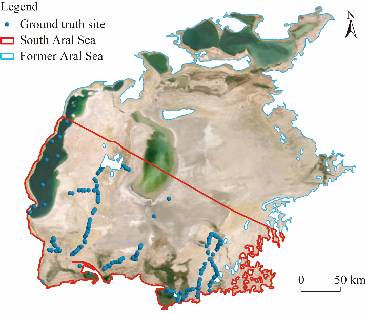
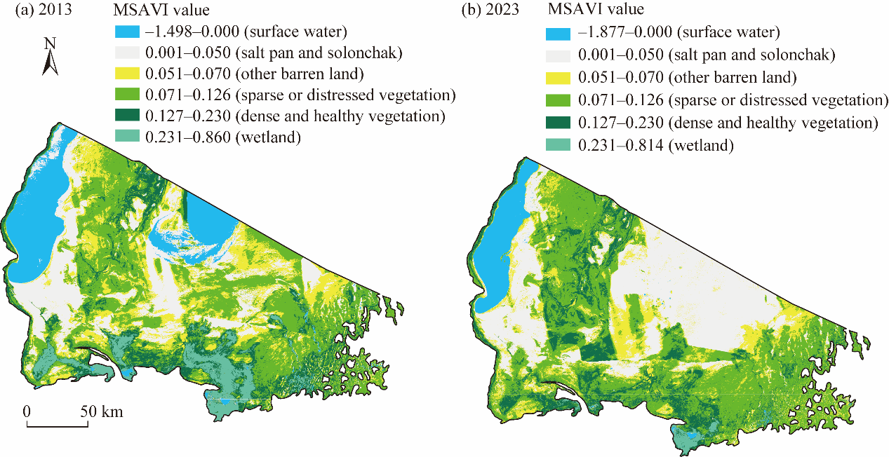
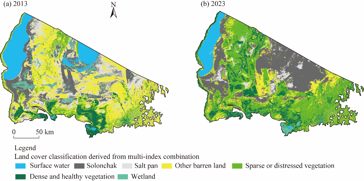
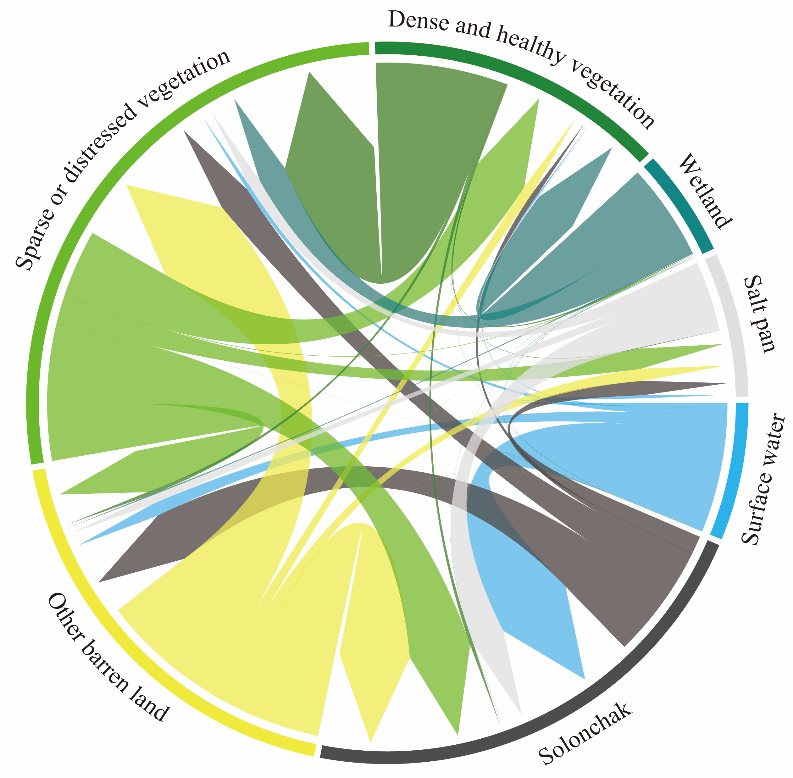
Abstract The South Aral Seabed is an extreme dryland ecosystem undergoing rapid transformation yet remains misrepresented or absent in global land cover datasets. Conventional vegetation indices, specifically the Normalized Difference Vegetation Index (NDVI), perform poorly in such environments due to their limited ability to distinguish sparse vegetation from highly reflective saline and sandy soils. This study evaluated the effectiveness of the Modified Soil Adjusted Vegetation Index (MSAVI) for improving land cover classification in the South Aral Seabed and conducted a decadal analysis of land cover change between 2013 and 2023 using Landsat 8 imagery (30 m resolution). A spectral index-based classification framework was developed, combining MSAVI with the Normalized Difference Water Index (NDWI) and Salinity Index 1 (SI1) to reduce spectral confusion between vegetation, saline soils, and surface water. The MSAVI-based classification achieved an overall accuracy of 77.96% (Kappa coefficient=0.71), supported by 313 field-collected validation points from 2023. While the multi-index approach enabled finer discrimination of ecologically important classes, particularly separating salt pans from solonchak soils, it resulted in a lower overall accuracy (73.80%), highlighting a trade-off between class separability and classification performance. Land cover change analysis revealed a highly dynamic landscape, with 52.96% of the study area transitioning between classes over the decade. Transformed areas (16,893 km2) exceeded stable zones (15,004 km2), driven primarily by rapid desiccation and salinization. Solonchak soils increased at an annual rate of 5.58%, while surface water bodies declined by 4.83% per year. Concurrently, sparse or distressed vegetation increased by 1.43% annually, reflecting ongoing afforestation efforts. This study provides the first MSAVI-based and medium-resolution land cover baseline for the South Aral Seabed and demonstrates that soil-adjusted vegetation indices are essential for reliable dryland classification where conventional indices fail. The proposed spectral index framework offers a replicable methodology applicable to other global drylands facing similar land degradation and restoration challenges.
|
|
Received: 22 October 2025
Published: 28 February 2026
|
|
Corresponding Authors:
*Shahzoda ALIKHANOVA (E-mail: shahzoda.alikhanova@biology.ox.ac.uk)
|
|
|
| [1] |
Abuelgasim A, Ammad R. 2019. Mapping soil salinity in arid and semi-arid regions using Landsat 8 OLI satellite data. Remote Sensing Applications: Society and Environment, 13: 415-425.
doi: 10.1016/j.rsase.2018.12.010
|
|
|
| [2] |
Ali U, Esau T J, Farooque A A, et al. 2022. Limiting the collection of ground truth data for land use and land cover maps with machine learning algorithms. ISPRS International Journal of Geo-Information, 11(6): 333, doi: 10.3390/IJGI11060333.
|
|
|
| [3] |
Alikhanova S, Bull J W. 2023. Review of nature-based solutions in dryland ecosystems: the Aral Sea case study. Environmental Management, 72(3): 457-472.
doi: 10.1007/s00267-023-01822-z
pmid: 37115238
|
|
|
| [4] |
Alikhanova S, Tarantino C, Bull J W. 2025. Tracking vegetation dynamics in drylands with MSAVI: Insights from the South Aral Sea. Earth Systems and Environment, doi: 10.1007/s41748-025-00705-z.
|
|
|
| [5] |
Andries A, Morse S, Murphy R J, et al. 2022. Using data from earth observation to support sustainable development indicators: An analysis of the literature and challenges for the future. Sustainability, 14(3): 1191, doi: 10.3390/SU14031191/S1.
|
|
|
| [6] |
Banks J R, Heinold B, Schepanski K. 2024. Dust aerosol from the Aralkum Desert influences the radiation budget and atmospheric dynamics of Central Asia. Atmospheric Chemistry and Physics, 24(20): 11451-11475.
|
|
|
| [7] |
Bao A M, Yu T, Xu W Q, et al. 2024. Ecological problems and ecological restoration zoning of the Aral Sea. Journal of Arid Land, 16(3): 315-330.
doi: 10.1007/s40333-024-0055-6
|
|
|
| [8] |
Barsi J A, Lee K, Kvaran G, et al. 2014. The spectral response of the Landsat-8 Operational Land Imager. Remote Sensing, 6(10): 10232-10251.
doi: 10.3390/rs61010232
|
|
|
| [9] |
Batsaikhan B, Lkhamjav O, Batsaikhan G, et al. 2020. Carbon stock estimation using remote sensing data and field measurement in Haloxylon ammodendron dominant winter cold desert region of Mongolia. ISPRS Annals of the Photogrammetry, Remote Sensing and Spatial Information Sciences, V-3-2020: 9-17.
|
|
|
| [10] |
Bedareva O M. 2009. Ecosystems of the middle deserts of Kazakhstan and their inventory using remote sensing methods. PhD Dissertation. Kaliningrad: Kaliningrad State University. (in Russian)
|
|
|
| [11] |
Belhadj A, Boulghobra N, Demnati Allache F. 2023. Multi-temporal Landsat imagery and MSAVI index for monitoring rangeland degradation in arid ecosystem, case study of Biskra (southeast Algeria). Environmental Monitoring and Assessment, 195(6): 656, doi: 10.1007/s10661-023-11191-z.
pmid: 37165277
|
|
|
| [12] |
Berdimbetov T, Ilyas S, Ma Z, et al. 2021a. Climatic change and human activities link to vegetation dynamics in the Aral Sea Basin using NDVI. Earth Systems and Environment, 5(2): 303-318.
doi: 10.1007/s41748-021-00224-7
|
|
|
| [13] |
Berdimbetov T, Ma Z G, Shelton S, et al. 2021b. Identifying land degradation and its driving factors in the Aral Sea Basin from 1982 to 2015. Frontiers in Earth Science, 9: 690000, doi: 10.3389/FEART.2021.690000.
|
|
|
| [14] |
Bestelmeyer B T, Okin G S, Duniway M C, et al. 2015. Desertification, land use, and the transformation of global drylands. Frontiers in Ecology and the Environment, 1(13): 28-36.
|
|
|
| [15] |
Bojinski S, Verstraete M, Peterson T C, et al. 2014. The concept of essential climate variables in support of climate research, applications, and policy. Bulletin of the American Meteorological Society, 95(9): 1431-1443.
doi: 10.1175/BAMS-D-13-00047.1
|
|
|
| [16] |
Breckle S W, Wucherer W. 2012. The Aralkum, a Man-Made Desert on the Desiccated Floor of the Aral Sea (Central Asia):General Introduction and Aims of the Book. Berlin and Heidelberg: Springer, 1-9.
|
|
|
| [17] |
Buchhorn M, Smets B, Bertels L, et al. 2020. Copernicus Global Land Service: Land Cover 100m: collection 3: epoch 2019: Globe. Zenodo. Version V3.0.1. [2025-08-10]. https://zenodo.org/records/3939050.
|
|
|
| [18] |
Cai T Y, Chang C C, Zhao Y B, et al. 2024. Within-season estimates of 10 m aboveground biomass based on Landsat, Sentinel-2 and PlanetScope data. Scientific Data, 11: 1276, doi: 10.1038/s41597-024-04120-3.
|
|
|
| [19] |
Cheţan M A, Dornik A, Urdea P. 2017. Comparison of object and pixel-based land cover classification through three supervised methods. Fachbeitrag, 142(4): 265-270.
|
|
|
| [20] |
Congalton R G, Green K. 2019. Assessing the Accuracy of Remotely Sensed Data: Principles and Practices (3rd ed.). Boca Raton: CRC Press, 55-74.
|
|
|
| [21] |
Duan Z H, Wang X L, Sun L. 2022. Monitoring and mapping of soil salinity on the exposed seabed of the Aral Sea, Central Asia. Water, 14(9): 1438, doi: 10.3390/w14091438.
|
|
|
| [22] |
Foody G M. 2020. Explaining the unsuitability of the kappa coefficient in the assessment and comparison of the accuracy of thematic maps obtained by image classification. Remote Sensing of Environment, 239: 111630, doi: 10.1016/j.rse.2019.111630.
|
|
|
| [23] |
Forestry Agency of the Ministry of Ecology Environmental Protection and Climate Change of the Republic of Uzbekistan. 2023. Information on Afforested Areas in the Aral Seabed from 1988-2023 (Unpublished data). Tashkent, Uzbekistan.
|
|
|
| [24] |
Friedl M A, McIver D K, Hodges J C F, et al. 2002. Global land cover mapping from MODIS: Algorithms and early results. Remote Sensing of Environment, 83(1-2): 287-302.
doi: 10.1016/S0034-4257(02)00078-0
|
|
|
| [25] |
Gilić F, Gašparović M, Baučić M. 2023. Current state and challenges in producing large-scale land cover maps: Review based on recent land cover products. Geocarto International, 38(1): 2242693, doi: 10.1080/10106049.2023.2242693.
|
|
|
| [26] |
Gorji T, Sertel E, Tanik A. 2017. Monitoring soil salinity via remote sensing technology under data scarce conditions: A case study from Turkey. Ecological Indicators, 74: 384-391.
doi: 10.1016/j.ecolind.2016.11.043
|
|
|
| [27] |
Gregorio A D, Jansen L J M. 2000. Land Cover Classification System (LCCS): Classification Concepts and User Manual for Software Version 1.0. Rome: Food and Agriculture Organization of the United Nations (FAO).
|
|
|
| [28] |
IUSS (International Union of Soil Sciences) Working Group. 2015. World Reference Base for Soil Resources 2014, Update 2015: International Soil Classification System for Naming Soils and Creating Legends for Soil Maps. World Soil Resources Reports No. 106. IUSS. Rome, Italy.
|
|
|
| [29] |
Khatami R, Mountrakis G, Stehman S V. 2016. A meta-analysis of remote sensing research on supervised pixel-based land-cover image classification processes: General guidelines for practitioners and future research. Remote Sensing of Environment, 177: 89-100.
doi: 10.1016/j.rse.2016.02.028
|
|
|
| [30] |
Khorram S, Koch F H, van der Wiele C F, et al. 2012. Remote Sensing. New York: Springer, 63-78.
|
|
|
| [31] |
Kim J, Song C, Lee S, et al. 2020. Identifying potential vegetation establishment areas on the dried Aral Sea floor using satellite images. Land Degradation and Development, 31(18): 2749-2762.
doi: 10.1002/ldr.v31.18
|
|
|
| [32] |
Kundu R. 2022. F1 Score in Machine Learning: Intro & Calculation. [2024-12-16]. https://www.v7labs.com/blog/f1-score-guide.
|
|
|
| [33] |
Liu L Y, Zhang X, Gao Y, et al. 2021. Finer-resolution mapping of global land cover: Recent developments, consistency analysis, and prospects. Journal of Remote Sensing, 2021: 5289697, doi: 10.34133/2021/5289697.
|
|
|
| [34] |
Liu S S, Xu G Q, Chen T Q, et al. 2023. Quantifying the effects of precipitation exclusion and groundwater drawdown on functional traits of Haloxylon ammodendron-How does this xeric shrub survive the drought? Science of The Total Environment, 904: 166945, doi: 10.1016/j.scitotenv.2023.166945.
|
|
|
| [35] |
Löw F, Dimov D, Kenjabaev S, et al. 2022. Land cover change detection in the Aralkum with multi-source satellite datasets. GIScience and Remote Sensing, 59(1): 17-35.
doi: 10.1080/15481603.2021.2009232
|
|
|
| [36] |
Ma Q L, Wang X Y, Chen F, et al. 2021. Carbon sequestration of sand-fixing plantation of Haloxylon ammodendron in Shiyang River Basin: Storage, rate and potential. Global Ecology and Conservation, 28: e01607, doi: 10.1016/j.gecco.2021.e01607.
|
|
|
| [37] |
Martín-López B, Church A, Başak Dessane E, et al. 2018. The IPBES Regional Assessment Report on Biodiversity and Ecosystem Services for Europe and Central Asia. Secretariat of the Intergovernmental Science-Policy Platform on Biodiversity and Ecosystem Services. Bonn, Germany.
|
|
|
| [38] |
Miura Y, Shamsudduha M, Suppasri A, et al. 2025. A global multi-sensor dataset of surface water indices from Landsat-8 and Sentinel-2 satellite measurements. Scientific Data, 12(1): 1253, doi: 10.1038/s41597-025-05562-z.
|
|
|
| [39] |
Nishonov B E, Kholmatjanov B M, Labzovskii L D, et al. 2023. Study of the strongest dust storm occurred in Uzbekistan in November 2021. Scientific Reports, 13(1): 20042, doi: 10.1038/s41598-023-42256-1.
|
|
|
| [40] |
Polat N, Kaya Y. 2021. Investigation of the performance of different pixel-based classification methods in land use/land cover (LULC) determination. Türkiye İnsansız Hava Araçları Dergisi, 3(1): 1-6.
doi: 10.51534/tiha.829656
|
|
|
| [41] |
Qi J, Chehbouni A, Huete A R, et al. 1994. A modified soil adjusted vegetation index. Remote Sensing of Environment, 48(2): 119-126.
doi: 10.1016/0034-4257(94)90134-1
|
|
|
| [42] |
Rawat D, Garg V, Thakur P K, et al. 2025. Tracing the impact of irrigation development on Aral Sea desiccation and land use dynamics using remote sensing. Journal of the Indian Society of Remote Sensing, doi: 10.1007/s12524-025-02308-7.
|
|
|
| [43] |
Safaei M, Bashari H, Kleinebecker T, et al. 2022. Mapping terrestrial ecosystem health in drylands: Comparison of field-based information with remotely sensed data at watershed level. Landscape Ecology, 38(3): 705-724.
doi: 10.1007/s10980-022-01454-4
|
|
|
| [44] |
Shamsutdinova E, Shamsutdinov Z. 2022. Biological features and forage performance of black saxaul (Haloxylon aphyllum (Minkw) Iljin) in the Central Asian desert. BIO Web of Conferences, 43: 01023, doi: 10.1051/bioconf/20224301023.
|
|
|
| [45] |
Shen H, Abuduwaili J, Ma L, et al. 2019. Remote sensing-based land surface change identification and prediction in the Aral Sea bed, Central Asia. International Journal of Environmental Science and Technology, 16(5): 2031-2046.
doi: 10.1007/s13762-018-1801-0
|
|
|
| [46] |
Sims N C, Barger N N, Metternicht G I, et al. 2020. A land degradation interpretation matrix for reporting on UN SDG indicator 15.3.1 and land degradation neutrality. Environmental Science and Policy, 114: 1-6.
doi: 10.1016/j.envsci.2020.07.015
|
|
|
| [47] |
Sims N C, Green C, Newnham G, et al. 2021. Good Practice Guidance:SDG Indicator 15.3.1, Proportion of Land That is Degraded Over Total Land Area (Version 2.0). In: United Nations Convention to Combat Desertification. United Nations. Bonn, Germany.
|
|
|
| [48] |
Smith W K, Dannenberg M P, Yan D, et al. 2019. Remote sensing of dryland ecosystem structure and function: Progress, challenges, and opportunities. Remote Sensing of Environment, 233: 111401, doi: 10.1016/j.rse.2019.111401.
|
|
|
| [49] |
Sokolova M, Lapalme G. 2009. A systematic analysis of performance measures for classification tasks. Information Process and Management, 45(4): 427-437.
|
|
|
| [50] |
Stulina G, Idirisov K. 2024. Soil cover in the eastern part of the dried bed of the Aral Sea. Journal of Geoscience and Environment Protection, 12(6): 30-37.
|
|
|
| [51] |
Su Y, Li X, Feng M, et al. 2021. High agricultural water consumption led to the continued shrinkage of the Aral Sea during 1992-2015. Science of The Total Environment, 777: 145993, doi: 10.1016/j.scitotenv.2021.145993.
|
|
|
| [52] |
Venter Z S, Barton D N, Chakraborty T, et al. 2022. Global 10 m land use land cover datasets: A comparison of dynamic world, world cover and Esri land cover. Remote Sensing, 14(16): 4101, doi: 10.3390/rs14164101.
|
|
|
| [53] |
Verma P, Raghubanshi A, Srivastava P K, et al. 2020. Appraisal of kappa-based metrics and disagreement indices of accuracy assessment for parametric and nonparametric techniques used in LULC classification and change detection. Modelling Earth Systems and Environment, 6(2): 1045-1059.
|
|
|
| [54] |
Wang H, Liu Y X, Wang Y J, et al. 2023. Land cover change in global drylands: A review. Science of The Total Environment, 863: 160943, doi: 10.1016/j.scitotenv.2022.160943.
|
|
|
| [55] |
Wang W, Samat A, Abuduwaili J, et al. 2022. Temporal characterization of sand and dust storm activity and its climatic and terrestrial drivers in the Aral Sea region. Atmospheric Research, 275: 106242, doi: 10.1016/j.atmosres.2022.106242.
|
|
|
| [56] |
Weih R C, Riggan N D. 2010. Object-based classification vs. pixel-based classification: Comparative importance of multi-resolution imagery. The International Archives of the Photogrammetry, Remote Sensing and Spatial Information Sciences, 38(Part 4): C7.
|
|
|
| [57] |
WMO (World Meteorological Organization). 2022. The 2022 GCOS Implementation Plan. GCOS-244, GOOS-272. Geneva: WMO.
|
|
|
| [58] |
WMO, UNEP (United Nations Environment Programme), ISC (International Science Council), et al. 2022. The 2022 GCOS ECVs Requirements. GCOS-245. Geneva: WMO.
|
|
|
| [59] |
Xu P P, Tsendbazar N E, Herold M, et al. 2024. Comparative validation of recent 10 m-resolution global land cover maps. Remote Sensing of Environment, 311: 114316, doi: 10.1016/j.rse.2024.114316.
|
|
|
| [60] |
Xu S X, Wang J L, Altansukh O, et al. 2023. Spatial-temporal pattern of desertification in the Selenge River Basin of Mongolia from 1990 to 2020. Frontiers in Environmental Science, 11: 1125583, doi: 10.3389/fenvs.2023.1125583.
|
|
|
| [61] |
Yang X F. 2025. Mapping desert shrub aboveground biomass in the Junggar Basin, Xinjiang, China using quantile regression forest (QRF). PeerJ, 13: e19099, doi: 10.7717/peerj.19099.
|
|
|
| [62] |
Zandler H, Faryabi S P, Ostrowski S. 2022. Contributions to satellite-based land cover classification, vegetation quantification and grassland monitoring in Central Asian highlands using Sentinel-2 and MODIS data. Frontiers in Environmental Science, 10: 684589, doi: 10.3389/fenvs.2022.684589.
|
|
|
| [63] |
Zhang R P, Zhou J H, Guo J, et al. 2023. Inversion models of aboveground grassland biomass in Xinjiang based on multisource data. Frontiers in Plant Science, 14: 1152432, doi: 10.3389/fpls.2023.1152432.
|
|
|
| [64] |
Zhang X Y, Liu H L, Chen H. 2021. Changes of vegetation and its forces driving in the Aral Sea Basin of Central Asia. E3S Web of Conferences, 269: 01013, doi: 10.1051/e3sconf/202126901013.
|
|
|
|
Viewed |
|
|
|
Full text
|
|
|
|
|
Abstract
|
|
|
|
|
Cited |
|
|
|
|
| |
Shared |
|
|
|
|
| |
Discussed |
|
|
|
|