| Research article |
|


|
|
|
| Assessing vegetation-terrain relationships based on the fusion of high-resolution ULS and SfM data for a topographically complex catchment in the semi-arid area, China |
YAN Lu1, GAO Jianjian2, TANG Bingzhe1, GUO Tong1, HU Jinfei1, DANG Tianmin3, LI Pengfei1,*( ) |
1 College of Geomatics, Xi'an University of Science and Technology, Xi'an 710054, China
2 Suide Test Station of Soil and Water Conservation, Yellow River Conservancy Committee of Ministry of Water Resources, Yulin 719000, China
3 Yellow River Basin Monitoring of Centre of Water-Soil Conservation and Eco-Environment, Xi'an 712100, China |
|
|
|
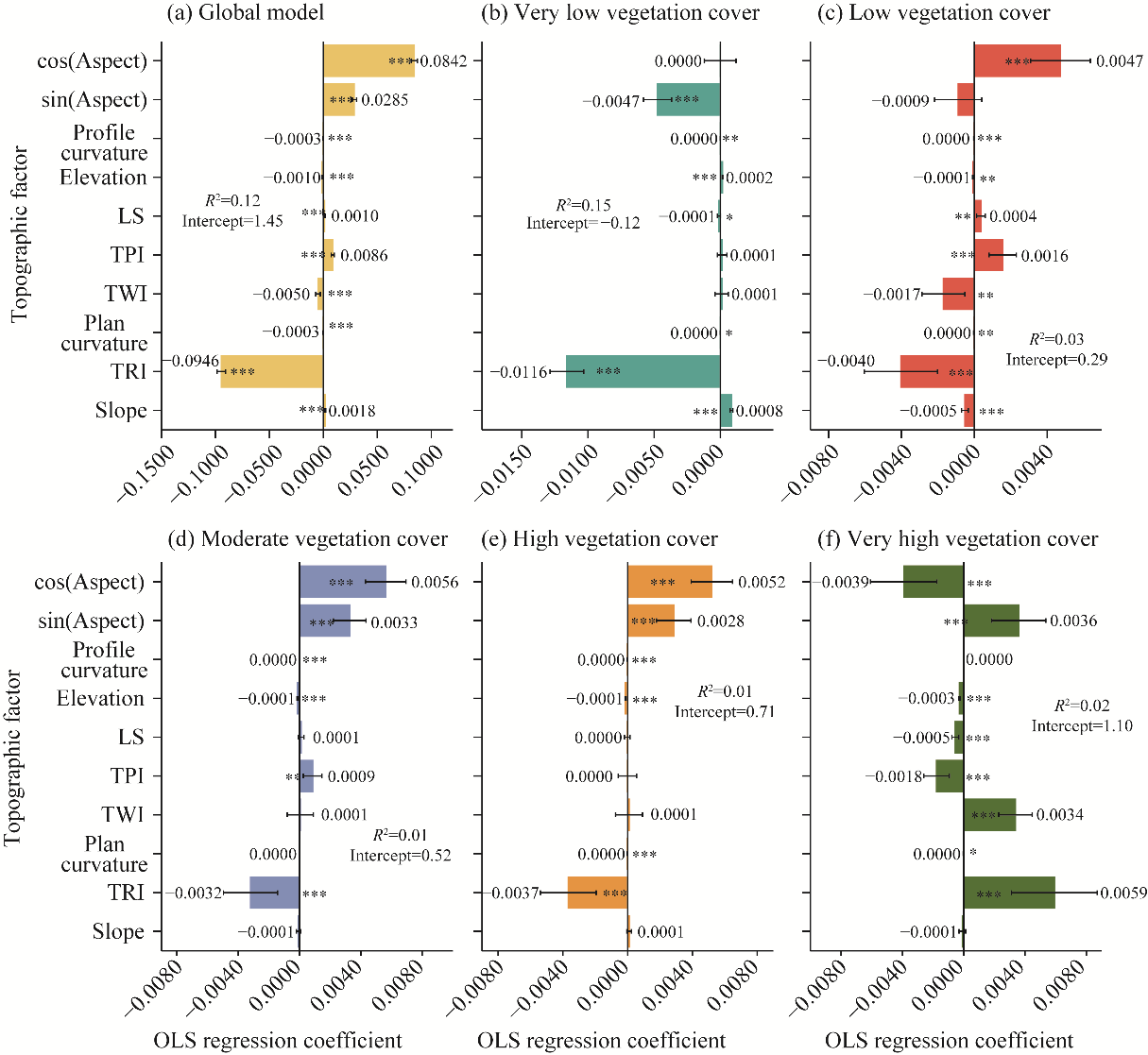
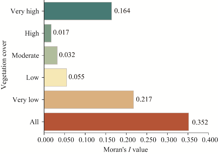
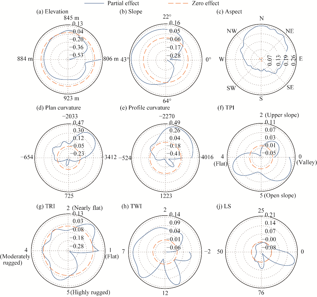
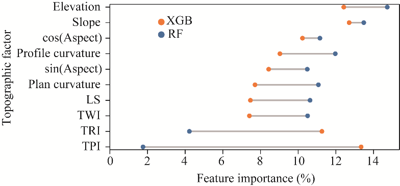
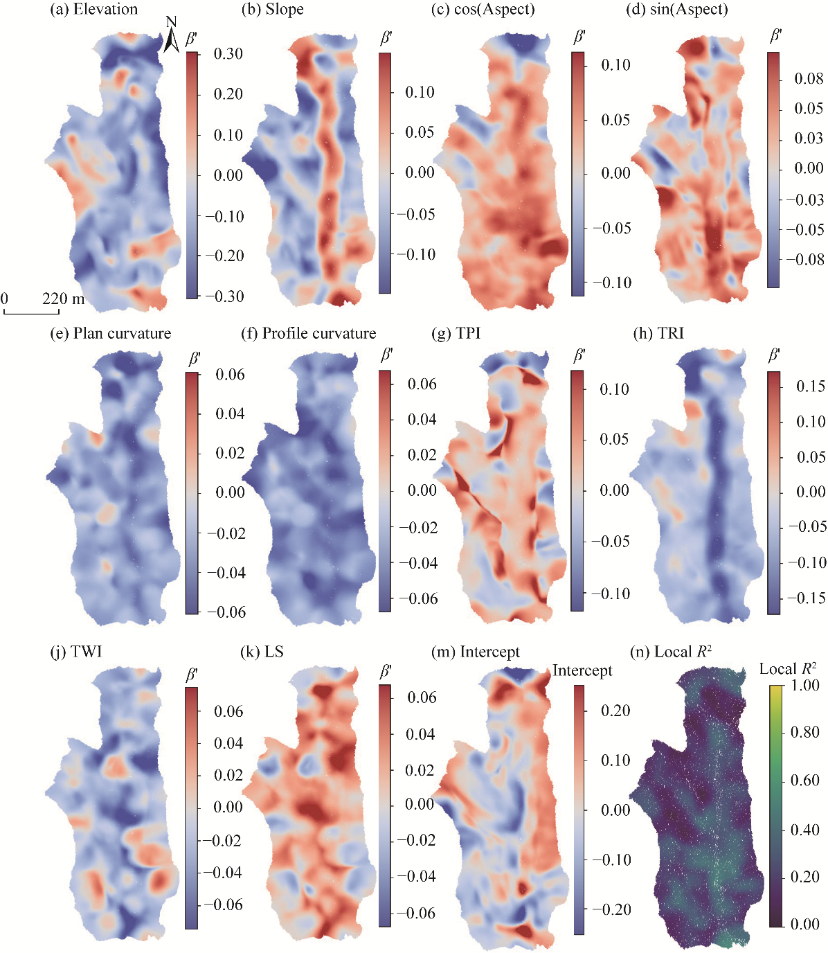
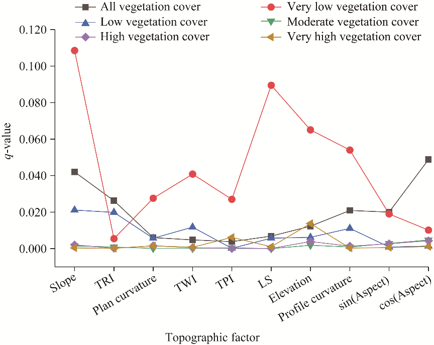
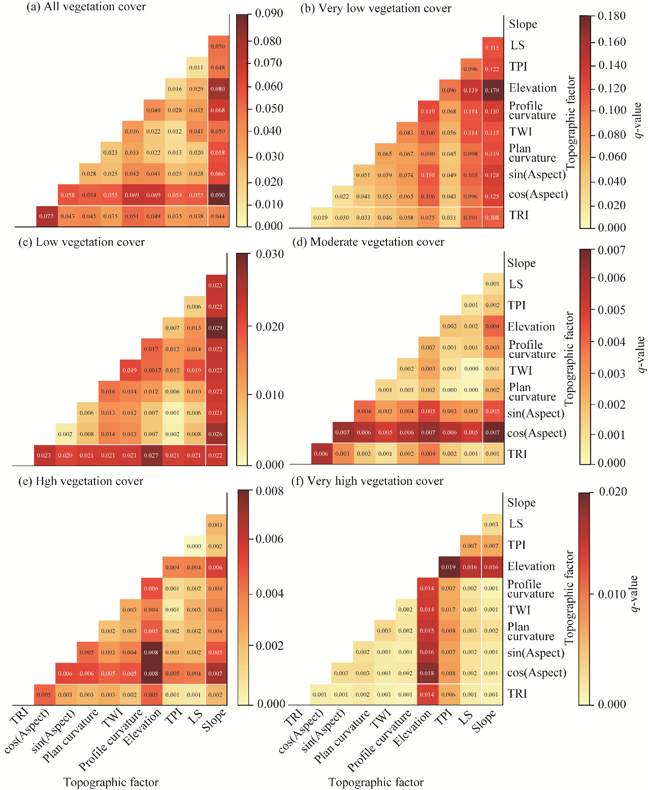
Abstract Topography plays a crucial role in regulating vegetation distribution through its control over solar radiation, soil moisture, and erosion-deposition dynamics. However, fine-scale vegetation-terrain relationships remain insufficiently understood because previous studies have relied on coarse- or single-source data and lacked an integrated analytical framework. This study integrated unmanned aerial vehicle laser scanning (ULS) and structure-from-motion (SfM) photogrammetry by mapping SfM orthophoto texture onto the ULS point cloud, to generate a unified high-resolution vegetation-terrain dataset for the Qiaogou catchment in the hilly and gully Loess Plateau, China. Nine topographic factors were derived from ULS digital elevation models (DEMs), while texture and vegetation indices were extracted from SfM imagery. The vegetation-terrain relationship was quantified using a hierarchical framework that sequentially evaluated the linear effects using ordinary least squares (OLS), nonlinear effects using generalized additive models (GAM), random forest (RF), and extreme gradient boosting (XGB), spatial non-stationarity using geographically weighted regression (GWR), and interaction among explanatory factors using Geodetector. Results showed that vegetation cover exhibited pronounced spatial heterogeneity, with dense vegetation primarily located on moist valley floors and sparse cover on steep and rugged slopes. Elevation and slope imposed the primary topographic constraints on vegetation cover, while terrain roughness index (TRI), topographic position index (TPI), topographic wetness index (TWI), and slope length factor (LS) provided complementary descriptors of local terrain variability and moisture conditions. Nonlinear models found that slope (45°) and wetness thresholds determined ecological stability limits, while spatial models revealed a significant non-stationarity (Moran's I=0.352) in topographic influence. Geodetector interaction analysis indicated that terrain effects were expressed mainly though factor combinations, with several slope-related pairs providing additional explanatory power beyond individual factor, while the single-factor explanatory power for overall vegetation cover remained modest. By fusing ULS and SfM data and integrating multi-level analytical models, this study provided a process-based and scale-consistent understanding of how geomorphic structure and hydrological connectivity co-regulated vegetation heterogeneity. The proposed framework offered a robust reference for high-resolution vegetation monitoring, eco-geomorphic modeling, and restoration planning in complex loess landscapes.
|
|
Received: 26 April 2026
Published: 30 November 2026
|
|
Corresponding Authors:
*LI Pengfei (E-mail: pengfeili@xust.edu.cn)
|
| About author: Author contributions
Conceptualization, data curation, formal analysis, investigation, methodology, validation, visualization, writing - original draft preparation, and funding acquisition: YAN Lu; Data curation, investigation, funding acquisition, and resources: GAO Jianjian; Funding acquisition, investigation, and software: TANG Bingzhe; Software and visualization: GUO Tong; Funding acquisition and validation: HU Jinfei; Resources and supervision: DANG Tianmin; Conceptualization, funding acquisition, project administration, supervision, and writing - review and editing: LI Pengfei. All authors approved the manuscript.
|
|
|
| [1] |
Bandai T, Ghezzehei T A. 2022. Forward and inverse modeling of water flow in unsaturated soils with discontinuous hydraulic conductivities using physics-informed neural networks with domain decomposition. Hydrology and Earth System Sciences, 26(16): 4469-4495.
|
|
|
| [2] |
Beven K J, Kirkby M J. 1979. A physically based, variable contributing area model of basin hydrology. Hydrological Sciences Bulletin, 24(1): 43-69.
|
|
|
| [3] |
Bueso D, Piles M, Ciais P, et al. 2023. Soil and vegetation water content identify the main terrestrial ecosystem changes. National Science Review, 10(5): nwad026, doi: 10.1093/nsr/nwad026.
|
|
|
| [4] |
Burnett B N, Meyer G A, McFadden L D. 2008. Aspect-related microclimatic influences on slope forms and processes, northeastern Arizona. Journal of Geophysical Research: Earth Surface, 113(F3): F03002, doi: 10.1029/2007JF000789.
|
|
|
| [5] |
Cantón Y, Del Barrio G, Solé-Benet A, et al. 2004. Topographic controls on the spatial distribution of ground cover in the Tabernas badlands of SE Spain. CATENA, 55(3): 341-365.
|
|
|
| [6] |
Cheng H, Zou X Y, Wu Y Q, et al. 2007. Morphology parameters of ephemeral gully in characteristics hillslopes on the Loess Plateau of China. Soil and Tillage Research, 94(1): 4-14.
|
|
|
| [7] |
Das A, Nagendra H, Anand M, et al. 2015. Topographic and bioclimatic determinants of the occurrence of forest and grassland in tropical montane forest-grassland mosaics of the Western Ghats, India. PLoS ONE, 10(6): e0130566, doi: 10.1371/journal.pone.0130566.
|
|
|
| [8] |
De Reu J, Bourgeois J, Bats M, et al. 2013. Application of the topographic position index to heterogeneous landscapes. Geomorphology, 186: 39-49.
|
|
|
| [9] |
Dearborn K D, Danby R K. 2017. Aspect and slope influence plant community composition more than elevation across forest-tundra ecotones in subarctic Canada. Journal of Vegetation Science, 28(3): 595-604.
|
|
|
| [10] |
Di Gregorio A. 2005. Land Cover Classification System: Classification Concepts and User Manual, Software Version 2. Rome: Food and Agriculture Organization of the United Nations.
|
|
|
| [11] |
Dietmaier A, McDermid G J, Rahman M M, et al. 2019. Comparison of LiDAR and digital aerial photogrammetry for characterizing canopy openings in the boreal forest of northern Alberta. Remote Sensing, 11(16): 1919, doi: 10.3390/rs11161919.
|
|
|
| [12] |
Fadl M A, Al-Yasi H M, Alsherif E A. 2021. Impact of elevation and slope aspect on floristic composition in Wadi Elkor, Sarawat Mountain, Saudi Arabia. Scientific Reports, 11: 16160, doi: 10.1038/s41598-021-95450-4.
|
|
|
| [13] |
Fan L, Wei T X, Zhang X M, et al. 2024. Spatiotemporal variation of land use in counties of the upper reaches of the Beiluo River and its impact on runoff and sediment. Journal of Beijing Forestry University, 46(2): 95-104. (in Chinese)
|
|
|
| [14] |
Filippelli S K, Lefsky M A, Rocca M E. 2019. Comparison and integration of liDAR and photogrammetric point clouds for mapping pre-fire forest structure. Remote Sensing of Environment, 224: 154-166.
|
|
|
| [15] |
Foley J A, Costa M H, Delire C, et al. 2003. Green surprise? How terrestrial ecosystems could affect Earth's climate. Frontiers in Ecology and the Environment, 1(1): 38-44.
|
|
|
| [16] |
Fotheringham A S. 2009. Geographically weighted regression. In: Fotheringham A S, Rogerson P A. The SAGE Handbook of Spatial Analysis. London: Sage, 243-253.
|
|
|
| [17] |
Gallant J C, Dowling T I. 2003. A multiresolution index of valley bottom flatness for mapping depositional areas. Water Resources Research, 39(12): 1347, doi: 10.1029/2002WR001426.
|
|
|
| [18] |
Gonçalves J A, Henriques R. 2015. UAV photogrammetry for topographic monitoring of coastal areas. ISPRS Journal of Photogrammetry and Remote Sensing, 104: 101-111.
|
|
|
| [19] |
He J, Shi X Y, Fu Y J. 2021. Identifying vegetation restoration effectiveness and driving factors on different micro-topographic types of hilly Loess Plateau: from the perspective of ecological resilience. Journal of Environmental Management, 289: 112562, doi: 10.1016/j.jenvman.2021.112562.
|
|
|
| [20] |
Iglhaut J, Cabo C, Puliti S, et al. 2019. Structure from motion photogrammetry in forestry: a review. Current Forestry Reports, 5: 155-168, doi: 10.1007/s40725-019-00094-3.
|
|
|
| [21] |
Jenness J. 2006. Topographic Position Index (tpi_jen.avx) extension for ArcView 3.x, v. 1.3a. Jenness Enterprises. [2026-01-12]. http://www.jennessent.com/arcview/tpi.htm.
|
|
|
| [22] |
Klaar M J, Kidd C, Malone E T, et al. 2015. Vegetation succession in deglaciated landscapes: implications for sediment and landscape stability. Earth Surface Processes and Landforms, 40(8): 1088-1100.
|
|
|
| [23] |
Körner C. 2007. The use of 'altitude' in ecological research. Trends in Ecology & Evolution, 22(11): 569-574.
|
|
|
| [24] |
Kutiel P, Lavee H, Ackermann O. 1998. Spatial distribution of soil surface coverage on north- and south-facing hillslopes along a Mediterranean to extreme arid climatic gradient. Geomorphology, 23(2-4): 245-256.
|
|
|
| [25] |
Li D, Li P F, Mu X M, et al. 2021. Accuracy of airborne LiDAR point cloud filtering for areas with complex terrain. Research of Soil and Water Conservation, 28(4): 171-178. (in Chinese)
|
|
|
| [26] |
Li D, Li P F, Hu J F, et al. 2025. Mapping catchment-scale soil erosion and deposition using an improved DoD method based on multitemporal UAV-borne laser scanning. IEEE Transactions on Geoscience and Remote Sensing, 63: 5701113, doi: 10.1109/tgrs.2025.3531495.
|
|
|
| [27] |
Li P F, Li D, Hu J F, et al. 2024. Improving the application of UAV-LiDAR for erosion monitoring through accounting for uncertainty in DEM of difference. CATENA, 234: 107534, doi: 10.1016/j.catena.2023.107534.
|
|
|
| [28] |
Li Q, Shi X Y, Wu Q Q. 2020. Exploring suitable topographical factor conditions for vegetation growth in Wanhuigou catchment on the Loess Plateau, China: a new perspective for ecological protection and restoration. Ecological Engineering, 158: 106053, doi: 10.1016/j.ecoleng.2020.106053.
|
|
|
| [29] |
Li Z, Zhang Y, Zhu Q K, et al. 2017. A gully erosion assessment model for the Chinese Loess Plateau based on changes in gully length and area. CATENA, 148: 195-203.
|
|
|
| [30] |
Liu X R, Peng Y X, Lu Z L, et al. 2023. Feature-fusion segmentation network for landslide detection using high-resolution remote sensing images and digital elevation model data. IEEE Transactions on Geoscience and Remote Sensing, 61: 4500314, doi: 10.1109/tgrs.2022.3233637.
|
|
|
| [31] |
Löbmann M T, Geitner C, Wellstein C, et al. 2020. The influence of herbaceous vegetation on slope stability-a review. Earth-Science Reviews, 209: 103328, doi: 10.1016/j.earscirev.2020.103328.
|
|
|
| [32] |
Moeslund J E, Arge L, Bøcher P K, et al. 2013. Topography as a driver of local terrestrial vascular plant diversity patterns. Nordic Journal of Botany, 31(2): 129-144.
|
|
|
| [33] |
Moore I D, Grayson R B, Ladson A R. 1991. Digital terrain modelling: a review of hydrological, geomorphological, and biological applications. Hydrological Processes, 5(1): 3-30.
|
|
|
| [34] |
Moore I D, Lewis A, Gallant J C. 1993. Terrain attributes:estimation methods and scale effects. In: Jakeman A J, Beck M B, McAleer M J. Modelling Change in Environmental Systems. Chichester: Wiley, 189-214.
|
|
|
| [35] |
Mulder V L, de Bruin S, Schaepman M E, et al. 2011. The use of remote sensing in soil and terrain mapping-a review. Geoderma, 162(1-2): 1-19.
|
|
|
| [36] |
Nouwakpo S K, Weltz M A, McGwire K. 2016. Assessing the performance of structure-from-motion photogrammetry and terrestrial LiDAR for reconstructing soil surface microtopography of naturally vegetated plots. Earth Surface Processes and Landforms, 41(3): 308-322.
|
|
|
| [37] |
Okyay U, Telling J, Glennie C L, et al. 2019. Airborne liDAR change detection: an overview of Earth sciences applications. Earth-Science Reviews, 198: 102929, doi: 10.1016/j.earscirev.2019.102929.
|
|
|
| [38] |
Orouskhani E, Sahoo S, Agyeman B, et al. 2023. Impact of sensor placement in soil water estimation: a real-case study. Irrigation Science, 41(3): 395-411.
|
|
|
| [39] |
Porporato A, Rodriguez-Iturbe I. 2002. Ecohydrology-a challenging multidisciplinary research perspective. Hydrological Sciences Journal, 47(5): 811-821.
|
|
|
| [40] |
Pouladi N, Gholizadeh A, Khosravi V, et al. 2023. Digital mapping of soil organic carbon using remote sensing data: a systematic review. CATENA, 232: 107409, doi: 10.1016/j.catena.2023.107409.
|
|
|
| [41] |
Radhamoni H V N, Queenborough S A, Arietta A Z A, et al. 2023. Local- and landscape-scale drivers of terrestrial herbaceous plant diversity along a tropical rainfall gradient in Western Ghats, India. Journal of Ecology, 111(5): 1021-1036.
|
|
|
| [42] |
Ran G, Xu X Z, Zhao Y, et al. 2026. How do vegetation patterns control gravity erosion in slope-gully systems under heavy rainfall on the Loess Plateau of China? Land Degradation & Development, 37(10): 5356-5371.
|
|
|
| [43] |
Ranjbar A, Vali A, Mokarram M, et al. 2020. Investigating variations of vegetation: climatic, geological substrate, and topographic factors-a case study of Kharestan area, Fars Province, Iran. Arabian Journal of Geosciences, 13: 597, doi: 10.1007/s12517-020-05615-0.
|
|
|
| [44] |
Razak K A, Santangelo M, van Westen C J, et al. 2013. Generating an optimal DTM from airborne laser scanning data for landslide mapping in a tropical forest environment. Geomorphology, 190: 112-125.
|
|
|
| [45] |
Renard K G, Foster G R, Weesies G A, et al. 1997. Predicting Soil Erosion by Water: A Guide to Conservation Planning with the Revised Universal Soil Loss Equation (RUSLE). Agriculture Handbook No. 703. Washington DC: U.S. Department of Agriculture.
|
|
|
| [46] |
Riley S J, DeGloria S D, Elliot R. 1999. A terrain ruggedness index that quantifies topographic heterogeneity. Intermountain Journal of Sciences, 5(1-4): 23-27.
|
|
|
| [47] |
Sankey T, Donager J, McVay J, et al. 2017. UAV liDAR and hyperspectral fusion for forest monitoring in the southwestern USA. Remote Sensing of Environment, 195: 30-43.
|
|
|
| [48] |
Seddon A W R, Macias-Fauria M, Long P R, et al. 2016. Sensitivity of global terrestrial ecosystems to climate variability. Nature, 531(7593): 229-232.
|
|
|
| [49] |
Sestras P, Badea G, Badea A C, et al. 2025. Land surveying with UAV photogrammetry and LiDAR for optimal building planning. Automation in Construction, 173: 106092, doi: 10.1016/j.autcon.2025.106092.
|
|
|
| [50] |
Sharma S, Thakur C, Sidhu N. 2026. Beyond elevation: unravelling land cover-elevation interactions in governing soil moisture variability in the lower Himalayas. Soil and Tillage Research, 257: 106982, doi: 10.1016/j.still.2025.106982.
|
|
|
| [51] |
Shi S H, Wang X L, Hu Z R, et al. 2023. Geographic detector-based quantitative assessment enhances attribution analysis of climate and topography factors to vegetation variation for spatial heterogeneity and coupling. Global Ecology and Conservation, 42: e02398, doi: 10.1016/j.gecco.2023.e02398.
|
|
|
| [52] |
Štroner M, Urban R, Křemen T, et al. 2023. UAV DTM acquisition in a forested area-comparison of low-cost photogrammetry (DJI Zenmuse P1) and LiDAR solutions (DJI Zenmuse L1). European Journal of Remote Sensing, 56(1): 2179942, doi: 10.1080/22797254.2023.2179942.
|
|
|
| [53] |
Sun W Y, Shao Q Q, Liu J Y. 2013. Soil erosion and its response to the changes of precipitation and vegetation cover on the Loess Plateau. Journal of Geographical Sciences, 23(6): 1091-1106.
|
|
|
| [54] |
Sun Y X, Liu S L, Liu C, et al. 2023. Interactive response and spatial heterogeneity of alpine grassland biodiversity to soil, topography, climate, and human factors on the Qinghai-Tibet Plateau. Land Degradation & Development, 34(15): 4488-4502.
|
|
|
| [55] |
Tian P, Tian X J, Geng R, et al. 2023. Response of soil erosion to vegetation restoration and terracing on the Loess Plateau. CATENA, 227: 107103, doi: 10.1016/j.catena.2023.107103.
|
|
|
| [56] |
Tsai F, Lai J S, Chen W W, et al. 2013. Analysis of topographic and vegetative factors with data mining for landslide verification. Ecological Engineering, 61: 669-677.
|
|
|
| [57] |
Tuo M Y, Qiao H L, Xu G C, et al. 2025. Effects of vegetation types on hillslope runoff and soil erosion on the Loess Plateau. CATENA, 260: 109487, doi: 10.1016/j.catena.2025.109487.
|
|
|
| [58] |
Tysiąc P, Moskalewicz D, Janowski Ł. 2025. Development of UAV-based LiDAR and multispectral measurement techniques for monitoring sediment intrusion in coastal wetlands. Measurement, 253: 117459, doi: 10.1016/j.measurement.2025.117459.
|
|
|
| [59] |
Wang G X, Liu G S, Li C J. 2012. Effects of changes in alpine grassland vegetation cover on hillslope hydrological processes in a permafrost watershed. Journal of Hydrology, 444-445: 22-33.
|
|
|
| [60] |
Wang J F, Li X H, Christakos G, et al. 2010. Geographical detectors-based health risk assessment and its application in the neural tube defects study of the Heshun region, China. International Journal of Geographical Information Science, 24(1): 107-127.
|
|
|
| [61] |
Wang X Q, Wang M M, Wang S Q, et al. 2015. Extraction of vegetation information from visible unmanned aerial vehicle images. Transactions of the Chinese Society of Agricultural Engineering, 31(5): 152-159. (in Chinese)
|
|
|
| [62] |
Wang Y W, Gao J, Guo Q C, et al. 2025. UAV-based LiDAR and optical imagery fusion for fine-scale classification of aquatic plant associations in lakeshore wetlands. Frontiers in Forests and Global Change, 8: 1698796, doi: 10.3389/ffgc.2025.1698796.
|
|
|
| [63] |
Western A W, Grayson R B, Blöschl G, et al. 1999. Observed spatial organization of soil moisture and its relation to terrain indices. Water Resources Research, 35(3): 797-810.
|
|
|
| [64] |
Wu S B, Chen L, Wang N L, et al. 2021. Variable scale effects on hillslope soil erosion during rainfall-runoff processes. CATENA, 207: 105606, doi: 10.1016/j.catena.2021.105606.
|
|
|
| [65] |
Xu X Z, Guo W Z, Liu Y K, et al. 2017. Landslides on the Loess Plateau of China: a latest statistics together with a close look. Natural Hazards, 86(3): 1393-1403.
|
|
|
| [66] |
Xu Y Z, Franklin S B, Wang Q G, et al. 2015. Topographic and biotic factors determine forest biomass spatial distribution in a subtropical mountain moist forest. Forest Ecology and Management, 357: 95-103.
|
|
|
| [67] |
Yan L, Bai X, Li P F, et al. 2024a. A multifactorial study of mass movement in the hilly and gully Loess Plateau based on intensive field surveys and remote sensing techniques. Science of The Total Environment, 924: 171628, doi: 10.1016/j.scitotenv.2024.171628.
|
|
|
| [68] |
Yan L, Li P F, Hu J F, et al. 2024b. Monitoring small-scale mass movement using unmanned aerial vehicle remote sensing techniques. CATENA, 238: 107885, doi: 10.1016/j.catena.2024.107885.
|
|
|
| [69] |
Yang A N, Wang C M, Yang Q K, et al. 2022. Choosing the right horizontal resolution for gully erosion susceptibility mapping using machine learning algorithms: a case in highly complex terrain. Remote Sensing, 14(11): 2580, doi: 10.3390/rs14112580.
|
|
|
| [70] |
Yang J, El-Kassaby Y A, Guan W B. 2020. The effect of slope aspect on vegetation attributes in a mountainous dry valley, Southwest China. Scientific Reports, 10: 16465, doi: 10.1038/s41598-020-73496-0.
|
|
|
| [71] |
Yang J S, Yao W Y, Wang L L. 2014. Study on the regularity and mechanism of gravity erosion in the loess gully. Yellow River, 36(6): 93-96. (in Chinese)
|
|
|
| [72] |
Yang L, Chen L D, Wei W. 2015. Effects of vegetation restoration on the spatial distribution of soil moisture at the hillslope scale in semi-arid regions. CATENA, 124: 138-146.
|
|
|
| [73] |
Yao Y, Liu Y X, Fu F Y, et al. 2024. Declined terrestrial ecosystem resilience. Global Change Biology, 30(4): e17291, doi: 10.1111/gcb.17291.
|
|
|
| [74] |
Zahura F T, Bisht G, Li Z, et al. 2024. Impact of topography and climate on post-fire vegetation recovery across different burn severity and land cover types through random forest. Ecological Informatics, 82: 102757, doi: 10.1016/j.ecoinf.2024.102757.
|
|
|
| [75] |
Zhang B Q, Wu P T, Zhao X N, et al. 2013. Changes in vegetation condition in areas with different gradients (1980-2010) on the Loess Plateau, China. Environmental Earth Sciences, 68(8): 2427-2438.
|
|
|
| [76] |
Zhang J J, Gao G Y, Fu B J, et al. 2020. Investigation of the relationship between precipitation extremes and sediment discharge production under extensive land cover change in the Chinese Loess Plateau. Geomorphology, 361: 107176, doi: 10.1016/j.geomorph.2020.107176.
|
|
|
| [77] |
Zhang J H, Zhang B Q, Wang X J, et al. 2026. Revegetation rebalances water resources by enhancing rainwater to increase vegetation carrying capacity in China's Loess Plateau. Water Resources Research, 62(1): e2025WR040307, doi: 10.1029/2025WR040307.
|
|
|
| [78] |
Zhang S H, Li X G, She J F, et al. 2019. Assimilating remote sensing data into GIS-based all sky solar radiation modeling for mountain terrain. Remote Sensing of Environment, 231: 111239, doi: 10.1016/j.rse.2019.111239.
|
|
|
| [79] |
Zhou P, Luukkanen O, Tokola T, et al. 2008. Effect of vegetation cover on soil erosion in a mountainous watershed. CATENA, 75(3): 319-325.
|
|
|
| [80] |
Zhou S X, Li P, Zhang Y, et al. 2023. Formation of new erosion-deposition patterns after farmland conversion: the major role of topography. CATENA, 231: 107349, doi: 10.1016/j.catena.2023.107349.
|
|
|
| [81] |
Zhou X, Wen Z F, Wu S J. 2025. How topographic factors regulate vegetation vigor in reservoir drawdown zones with different levels of hydrological disturbances? Ecological Indicators, 178: 114006, doi: 10.1016/j.ecolind.2025.114006.
|
|
|
| [82] |
Zhu P Z, Zhang G H, Wang H X, et al. 2020. Land surface roughness affected by vegetation restoration age and types on the Loess Plateau of China. Geoderma, 366: 114240, doi: 10.1016/j.geoderma.2020.114240.
|
|
|
| [83] |
Zou L Q, Tian F, Liang T C, et al. 2025. Topographic effects on vegetation greening and area expansion in global alpine zones under climate change. International Journal of Applied Earth Observation and Geoinformation, 142: 104727, doi: 10.1016/j.jag.2025.104727.
|
|
|
|
Viewed |
|
|
|
Full text
|
|
|
|
|
Abstract
|
|
|
|
|
Cited |
|
|
|
|
| |
Shared |
|
|
|
|
| |
Discussed |
|
|
|
|