| Geography, geology and natural resources in Central Asia (Guest Editorial Board Member:Prof. Dr. XIAO Wenjiao) |
|


|
|
|
| Land use/land cover change responses to ecological water conveyance in the lower reaches of Tarim River, China |
WANG Shanshan1,2,3,4,*( ), ZHOU Kefa1,2,3, ZUO Qiting5, WANG Jinlin1,2,3,4, WANG Wei1,2,3 ), ZHOU Kefa1,2,3, ZUO Qiting5, WANG Jinlin1,2,3,4, WANG Wei1,2,3 |
1State Key Laboratory of Desert and Oasis Ecology, Xinjiang Institute of Ecology and Geography, Chinese Academy of Sciences, Urumqi 830011, China
2Xinjiang Key Laboratory of Mineral Resources and Digital Geology, Urumqi 830011, China
3Xinjiang Research Centre for Mineral Resources, Chinese Academy of Sciences, Urumqi 830011, China
4University of Chinese Academy of Sciences, Beijing 100049, China
5School of Water Conservancy & Environment, Zhengzhou University, Zhengzhou 450001, China |
|
|
|
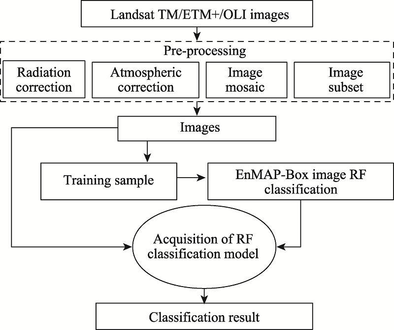
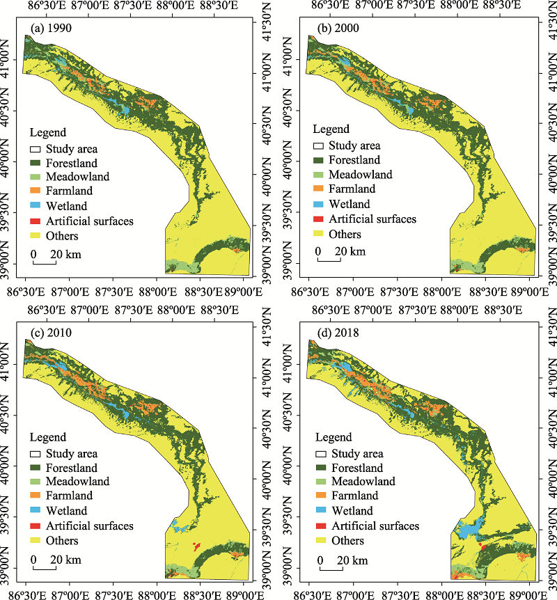
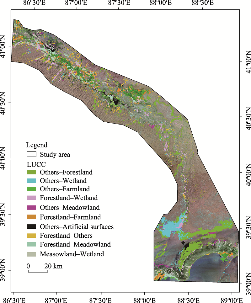
Abstract The Tarim River is the longest inland river in China and is considered as an important river to protect the oasis economy and environment of the Tarim Basin. However, excessive exploitation and over-utilization of natural resources, particularly water resources, have triggered a series of ecological and environmental problems, such as the reduction in the volume of water in the main river, deterioration of water quality, drying up of downstream rivers, degradation of vegetation, and land desertification. In this study, the land use/land cover change (LUCC) responses to ecological water conveyance in the lower reaches of the Tarim River were investigated using ENVI (Environment for Visualizing Images) and GIS (Geographic Information System) data analysis software for the period of 1990-2018. Multi-temporal remote sensing images and ecological water conveyance data from 1990 to 2018 were used. The results indicate that LUCC covered an area of 2644.34 km2 during this period, accounting for 15.79% of the total study area. From 1990 to 2018, wetland, farmland, forestland, and artificial surfaces increased by 533.42 km2 (216.77%), 446.68 km2 (123.66%), 284.55 km2 (5.67%), and 57.51 km2 (217.96%), respectively, whereas areas covered by grassland and other land use/land cover types, such as Gobi, bare soil, and deserts, decreased by 103.34 km2 (14.31%) and 1218.83 km2 (11.75%), respectively. Vegetation area decreased first and then increased, with the order of 2010<2000<1990<2018. LUCC in the overflow and stagnant areas in the lower reaches of the Tarim River was mainly characterized by fragmentation, irregularity, and complexity. By analyzing the LUCC responses to 19 rounds of ecological water conveyance in the lower reaches of the Tarim River from 2000 to the end of 2018, we proposed guidelines for the rational development and utilization of water and soil resources and formulation of strategies for the sustainable development of the lower reaches of the Tarim River. This study provides scientific guidance for optimal scheduling of water resources in the region.
|
|
Received: 31 October 2020
Published: 31 December 2021
|
|
Corresponding Authors:
*WANG Shanshan (E-mail: wangshanshan@ms.xjb.ac.cn)
|
|
|
| [1] |
Ablekim A, Kasimu A, Kurban A, et al. 2016. Evolution of small lakes in lower reaches of Tarim River based on multi-source spatial data. Geographical Research, 35(11): 2071-2090. (in Chinese)
|
|
|
| [2] |
Bai Y, Xu H L, Zhang Q Q, et al. 2015. Evaluation on ecological water requirement in the lower reaches of Tarim River based on groundwater restoration. Acta Ecologica Sinica, 35(3): 630-640. (in Chinese)
|
|
|
| [3] |
Bao A, Huang Y, Ma Y, et al. 2017. Assessing the effect of EWDP on vegetation restoration by remote sensing in the lower reaches of Tarim River. Ecological Indicators, 74: 261-275.
doi: 10.1016/j.ecolind.2016.11.007
|
|
|
| [4] |
Breiman L. 2001. Random forests. Machine Learning, 45: 5-32.
doi: 10.1023/A:1010933404324
|
|
|
| [5] |
Chen Y N, Zhang X L, Zhu X M, et al. 2004. Ecological effect analysis of water conveyance in the downstream of Tarim River in Xinjiang. Science in China Series D: Earth Sciences, 34(5): 475-482. (in Chinese)
|
|
|
| [6] |
Chen Y N, Pang Z H, Chen Y P, et al. 2008. Response of riparian vegetation to water-table changes in the lower reaches of Tarim River, Xinjiang Uygur Autonomous Region, China. Hydrogeology Journal, 16: 1371-1379.
doi: 10.1007/s10040-008-0306-1
|
|
|
| [7] |
Chen Y N, Li Z, Fan Y T, et al. 2015a. Progress and prospects of climate change impacts on hydrology in the arid region of northwest China. Environmental Research, 139: 11-19.
doi: 10.1016/j.envres.2014.12.029
|
|
|
| [8] |
Chen Y N, Li W H, Xu C C, et al. 2015b. Desert riparian vegetation and groundwater in the lower reaches of the Tarim River basin. Environmental Earth Sciences, 73: 547-558.
doi: 10.1007/s12665-013-3002-y
|
|
|
| [9] |
Chen Y N, Hao X M, Chen Y P, et al. 2019. Research on water system connectivity and ecological protection countermeasures in Tarim River Basin, Xinjiang. Proceedings of the Chinese Academy of Sciences, 34(10): 1156-1164. (in Chinese)
|
|
|
| [10] |
Chen Y N, Zhang X L, Fang G H, et al. 2020. Potential risks and challenges of climate change in the arid region of northwestern China. Regional Sustainability, 1(1): 20-30.
doi: 10.1016/j.regsus.2020.06.003
|
|
|
| [11] |
Demarchi L, Canters F, Claude C, et al. 2014. Assessing the performance of two unsupervised dimensionality reduction techniques on hyperspectral APEX data for high resolution urban land-cover mapping. ISPRS Journal of Photogrammetry and Remote Sensing, 87: 166-179.
doi: 10.1016/j.isprsjprs.2013.10.012
|
|
|
| [12] |
Deng M J, Zhou H Y, Xu H Q, et al. 2016. Research on the ecological operation in the lower reaches of Tarim River based on water conveyance. Scientia Sinica Technologica, 46(8): 864-876. (in Chinese)
|
|
|
| [13] |
Deng M J, Yang P N, Zhou H Y, et al. 2017. Water conversion and strategy of ecological water conveyance in the lower reaches of the Tarim River. Arid Zone Research, 34(4): 717-726. (in Chinese)
|
|
|
| [14] |
El-Tantawi A M, Bao A M, Chang C, et al. 2019. Monitoring and predicting land use/cover changes in the Aksu-Tarim River Basin, Xinjiang, China (1990-2030). Environmental Monitoring and Assessment, 191: 480-498.
doi: 10.1007/s10661-019-7478-0
pmid: 31270626
|
|
|
| [15] |
Fan Y, Chen Y, Liu Y, et al. 2013. Variation of base flows in the headstreams of the Tarim River Basin during 1960-2007. Journal of Hydrology, 487: 98-108.
doi: 10.1016/j.jhydrol.2013.02.037
|
|
|
| [16] |
Fan Y, Chen Y, Li W. 2014. Increasing precipitation and base flow in Aksu River since the 1950s. Quaternary International, 336: 26-34.
doi: 10.1016/j.quaint.2013.09.037
|
|
|
| [17] |
Guo H, Jiapaer G, Bao A, et al. 2017. Effects of the Tarim River's middle stream water transport dike on the fractional cover of desert riparian vegetation. Ecological Engineering, 99: 333-342.
doi: 10.1016/j.ecoleng.2016.10.074
|
|
|
| [18] |
Hao H M, Ren Z Y. 2009. Land use/land cover change (LUCC) and eco-environment response to LUCC in Farming-Pastoral Zone, China. Agricultural Sciences in China, 8(1): 91-97.
doi: 10.1016/S1671-2927(09)60013-4
|
|
|
| [19] |
Hartmann H, Snow J A, Su B, et al. 2016. Seasonal predictions of precipitation in the Aksu-Tarim River basin for improved water resources management. Global and Planetary Change, 147: 86-96.
doi: 10.1016/j.gloplacha.2016.10.018
|
|
|
| [20] |
Hasselmann F, Csaplovics E, Falconer I, et al. 2010. Technological driving forces of LUCC: Conceptualization, quantification, and the example of urban power distribution networks. Land Use Policy, 27(2): 628-637.
doi: 10.1016/j.landusepol.2009.08.016
|
|
|
| [21] |
He L H, Bao Q S, Sui M M. 2010. Application of land use status classification in land use status survey. Anhui Agricultural Science, (7): 440-442. (in Chinese)
|
|
|
| [22] |
Huang Q, Wang R H, Wu S X. 2006. Dynamic change of landscape pattern and hydrological & geochemical characteristic analysis before and after the emergency water transportation in the lower reaches of the Tarim River, China. Chinese Journal of Geochemistry, 25(1): 274-275.
|
|
|
| [23] |
Huang S, Wortmann M, Duethmann D, et al. 2018. Adaptation strategies of agriculture and water management to climate change in the Upper Tarim River basin, NW China. Agricultural Water Management, 203: 207-224.
doi: 10.1016/j.agwat.2018.03.004
|
|
|
| [24] |
Jiang P, Cheng L, Li M, et al. 2015. Impacts of LUCC on soil properties in the riparian zones of desert oasis with remote sensing data: A case study of the middle Heihe River basin, China. Science of the Total Environment, 506-507: 259-271.
doi: 10.1016/j.scitotenv.2014.11.004
|
|
|
| [25] |
Keram A, Halik Ü, Keyimu M, et al. 2019. Gap dynamics of natural Populus euphratica floodplain forests affected by hydrological alteration along the Tarim River: Implications for restoration of the riparian forests. Forest Ecology and Management, 438: 103-113.
doi: 10.1016/j.foreco.2019.02.009
|
|
|
| [26] |
Keyimu M, Halik Ü, Kurban A. 2017. Estimation of water consumption of riparian forest in the lower reaches of Tarim River, northwest China. Environmental Earth Sciences, 76: 547-558.
doi: 10.1007/s12665-017-6801-8
|
|
|
| [27] |
Li Q Y, Sun Y W, Yuan W L, et al. 2017. Streamflow responses to climate change and LUCC in a semi-arid watershed of Chinese Loess Plateau. Journal of Arid Land, 9(4): 609-621.
doi: 10.1007/s40333-017-0095-2
|
|
|
| [28] |
Li W W, Huang F, Shi F Z, et al. 2021. Human and climatic drivers of land and water use from 1997 to 2019 in Tarim River basin, China. International Soil and Water Conservation Research, 9(4): 532-543.
doi: 10.1016/j.iswcr.2021.05.001
|
|
|
| [29] |
Ling H, Guo B, Zhang G, et al. 2019. Evaluation of the ecological protective effect of the ''large basin'' comprehensive management system in the Tarim River basin, China. Science of the Total Environment, 650: 1696-1706.
doi: 10.1016/j.scitotenv.2018.09.327
|
|
|
| [30] |
Liu G, Kurban A, Duan H, et al. 2014. Desert riparian forest colonization in the lower reaches of Tarim River based on remote sensing analysis. Environmental Earth Sciences, 71: 4579-4589.
doi: 10.1007/s12665-013-2850-9
|
|
|
| [31] |
Lu X, Jiang T. 2009. Larger Asian rivers: Climate change, river flow and sediment flux. Quaternary International, 208(1-2): 1-3.
doi: 10.1016/j.quaint.2009.06.012
|
|
|
| [32] |
Schirpke U, Leitinger G, Tappeiner U, et al. 2012. SPA-LUCC: Developing land-use/cover scenarios in mountain landscapes. Ecological Informatics, 12: 68-76.
doi: 10.1016/j.ecoinf.2012.09.002
|
|
|
| [33] |
Shi Y, Wang R, Fan L, et al. 2010. Analysis on land-use change and its demographic factors in the original-stream watershed of Tarim River based on GIS and statistic. Procedia Environmental Sciences, 2: 175-184.
doi: 10.1016/j.proenv.2010.10.021
|
|
|
| [34] |
Sun Z, Chang N B, Opp C, et al. 2011. Evaluation of ecological restoration through vegetation patterns in the lower Tarim River, China with MODIS NDVI data. Ecological Informatics, 6(2): 156-163.
doi: 10.1016/j.ecoinf.2010.10.002
|
|
|
| [35] |
Wan H M. 2012. Remote sensing measure of vegetation restoration in the lower reaches of Tarim River. MSc Thesis. Urumqi: Xinjiang Agricultural University. (in Chinese)
|
|
|
| [36] |
Wang F, Yang S, Wei Y, et al. 2021. Characterizing soil salinity at multiple depth using electromagnetic induction and remote sensing data with random forests: A case study in Tarim River Basin of southern Xinjiang, China. Science of the Total Environment, 754: 142-153.
|
|
|
| [37] |
Wang X X, Chen Y N, Li Z, et al. 2020. The impact of climate change and human activities on the Aral Sea Basin over the past 50 years. Atmospheric Research, 245: 105-125.
|
|
|
| [38] |
Wang Y, Song G E, Wang P. 2017. Study on the change characteristics and spatial-temporal pattern of land use types in Songnen Gao Pingyuan. Resources and environment in arid areas, 31: 61-66. (in Chinese)
|
|
|
| [39] |
Wang Y G, Guo Y H. 2018. Characteristics of oasis in the lower reaches of Tarim River before and after ecological water conveyance. Desert and Oasis Weather, 12(2): 37-42. (in Chinese)
|
|
|
| [40] |
Wu X Q, Cai Y L. 2004. Land cover changes and landscape dynamics assessment in lower reaches of Tarim River in China. Chinese Geographical Science, 14(1): 28-33.
doi: 10.1007/s11769-004-0005-3
|
|
|
| [41] |
Xu H L, Fan Z L, Yang P N, et al. 2015. Tarim River recent management evaluation and comprehensive watershed planning recommendations. Arid Land Geography, 38(4): 645-651. (in Chinese)
|
|
|
| [42] |
Xu M, Wang X, Sun T, et al. 2019. Water balance change and its implications to vegetation in the Tarim River Basin, Central Asia. Quaternary International, 523: 25-36.
doi: 10.1016/j.quaint.2019.06.011
|
|
|
| [43] |
Ye Z X, Chen Y N, Li W H, et al. 2009. Effect of the ecological water conveyance project on environment in the lower Tarim River, Xinjiang, China. Environmental Monitoring and Assessment, 149: 9-17.
doi: 10.1007/s10661-008-0178-9
|
|
|
| [44] |
Ye Z X, Chen Y N, Li W H. 2010. Ecological water demand of natural vegetation in the lower Tarim River. Journal of Geographical Sciences, 20(2): 261-272.
doi: 10.1007/s11442-010-0261-3
|
|
|
| [45] |
Ye Z X, Chen Y N, Li W H. 2014a. Ecological water rights and water-resource exploitation in the three headwaters of the Tarim River. Quaternary International, 336: 20-25.
doi: 10.1016/j.quaint.2013.09.029
|
|
|
| [46] |
Ye Z X, Chen Y N, Zhang X L. 2014b. Dynamics of runoff, river sediments and climate change in the upper reaches of the Tarim River, China. Quaternary International, 336: 13-19.
doi: 10.1016/j.quaint.2013.06.006
|
|
|
| [47] |
Yu G A, Disse M, Huang H Q, et al. 2016. River network evolution and fluvial process responses to human activity in a hyper-arid environment - Case of the Tarim River in Northwest China. CATENA, 147: 96-109.
doi: 10.1016/j.catena.2016.06.038
|
|
|
| [48] |
Yu P J, Xu H L, Ye M, et al. 2012. Effects of ecological water conveyance on the ring increments of Populus euphratica in the lower reaches of Tarim River. Journal of Forest Research, 17(5): 413-420.
doi: 10.1007/s10310-011-0312-3
|
|
|
| [49] |
Zhang X Q, Chen Y N, Li W H, et al. 2013. Restoration of the lower reaches of the Tarim River in China. Regional Environmental Change, 13: 1021-1029.
doi: 10.1007/s10113-013-0403-0
|
|
|
| [50] |
Zhang X Q, Xia Q, Chen Y N, et al. 2021. Effects of ecological water conveyance on gross primary productivity of vegetation in Tarim River in recent 20 years. Arid Land Geography, 44(3): 718-728. (in Chinese)
|
|
|
| [51] |
Zhou H H, Chen Y N, Zhu C G, et al. 2020. Climate change may accelerate the decline of desert riparian forest in the lower Tarim River, Northwestern China: Evidence from tree-rings of Populus euphratica. Ecological Indicators, 111: 105-197.
|
|
|
| [52] |
Zhu C M, Li J L, Shen Z F, et al. 2019. Spatiotemporal dynamics of vegetation activities in the lower reach of the Tarim River based on MODIS intensive time series data. Resources Science, 41(3): 591-600. (in Chinese)
|
|
|
| [53] |
Zuo J P, Xu J H, Chen Y N, et al. 2021. Downscaling simulation of groundwater storage in the Tarim River basin in northwest China based on GRACE data. Physics and Chemistry of the Earth, 123: 103-142.
|
|
|
|
Viewed |
|
|
|
Full text
|
|
|
|
|
Abstract
|
|
|
|
|
Cited |
|
|
|
|
| |
Shared |
|
|
|
|
| |
Discussed |
|
|
|
|