| Research article |
|


|
|
|
| Enhancing ecological network connectivity in semi-arid mountain areas through minimal landscape restructuring |
PAN Yilu1,2, YANG Xia1,2, FANG Yuxuan1,2, PAN Hongyi1,2,*( ), ZHANG Wen3 ), ZHANG Wen3 |
1Faculty of Geography and Resources Sciences, Sichuan Normal University, Chengdu 610066, China
2Key Laboratory of Land Resources Evaluation and Monitoring in Southwest, Ministry of Education, Chengdu 610066, China
3School of Civil Engineering and Water Resources, Qinghai University, Xining 810016, China |
|
|
|
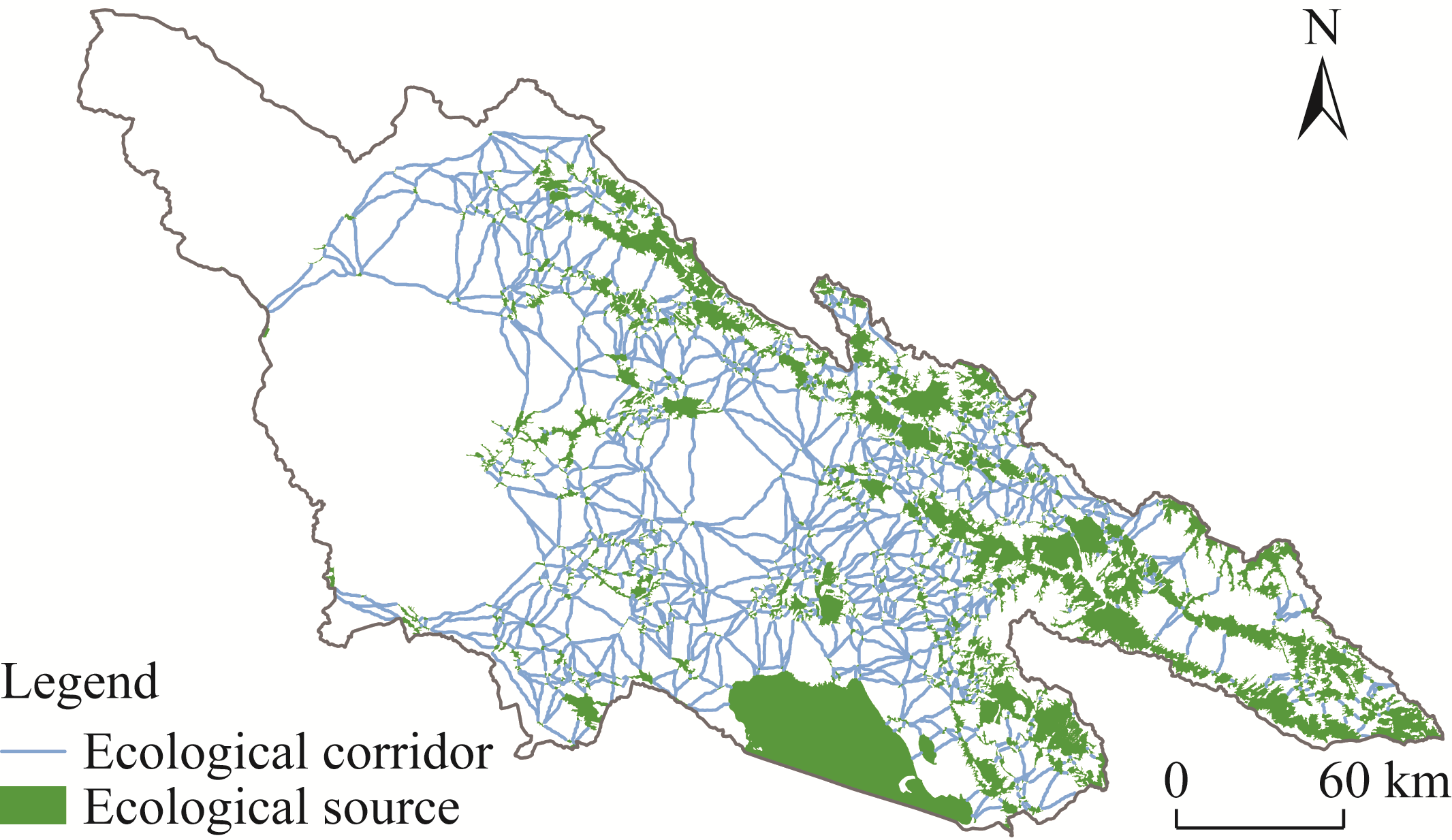
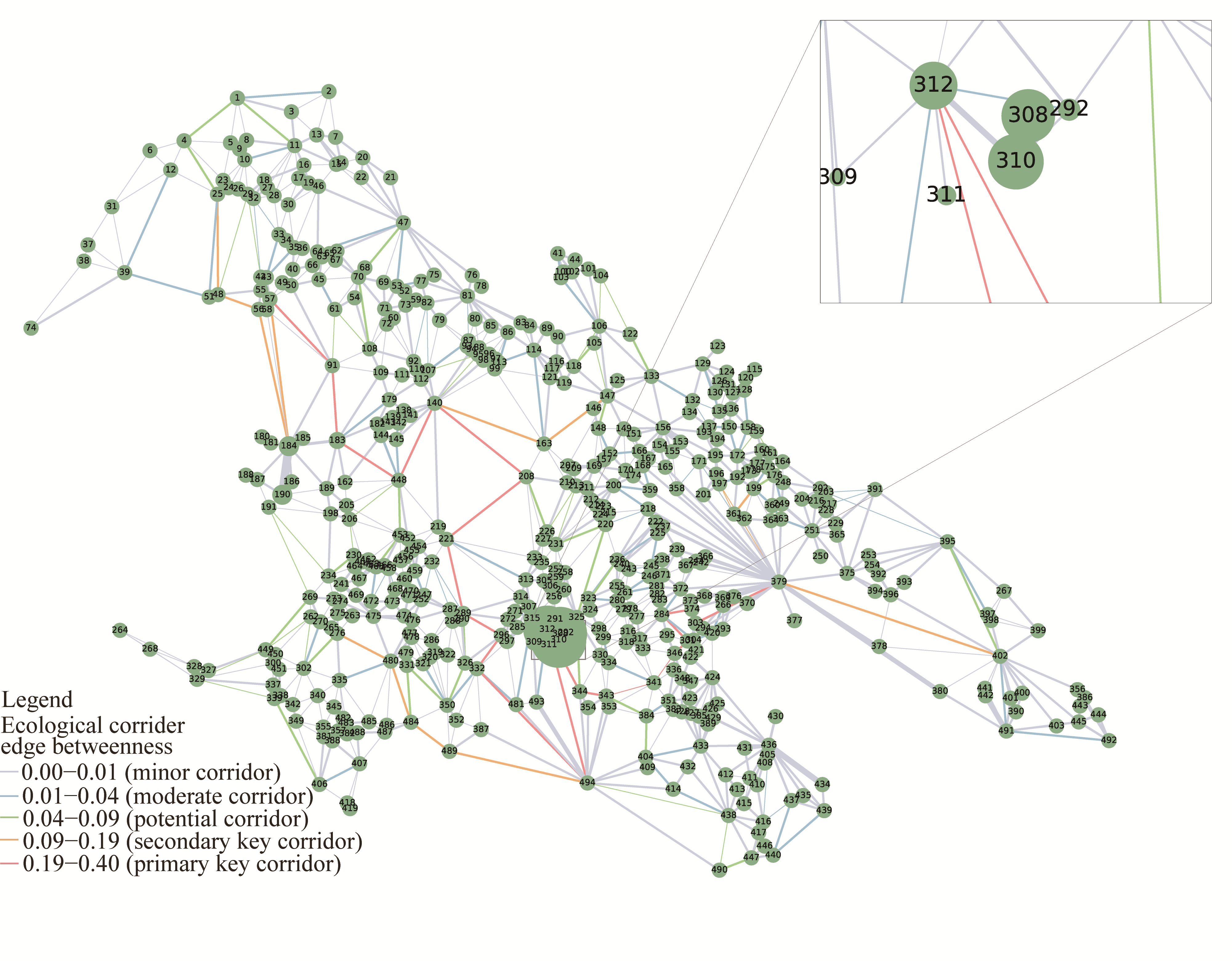
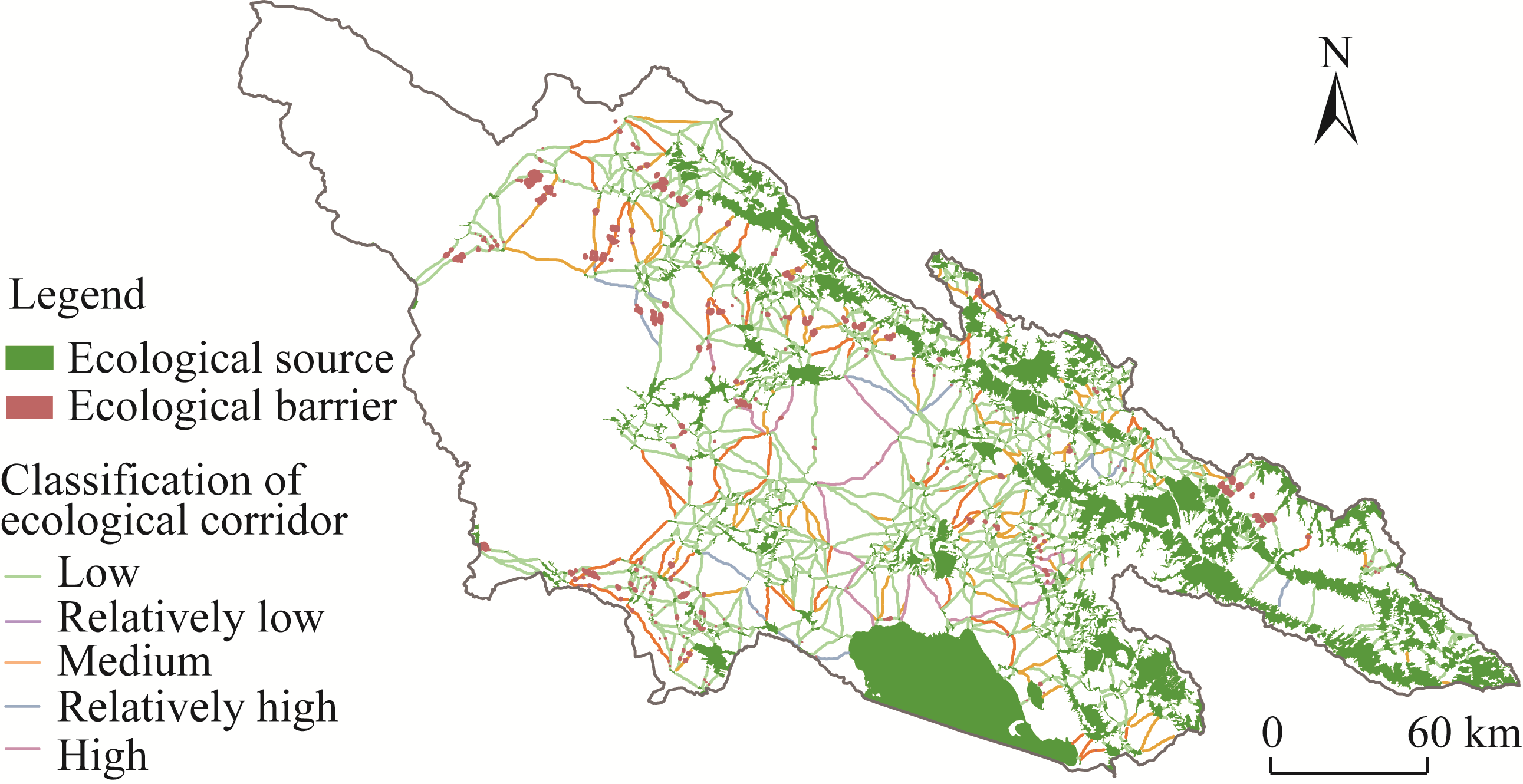
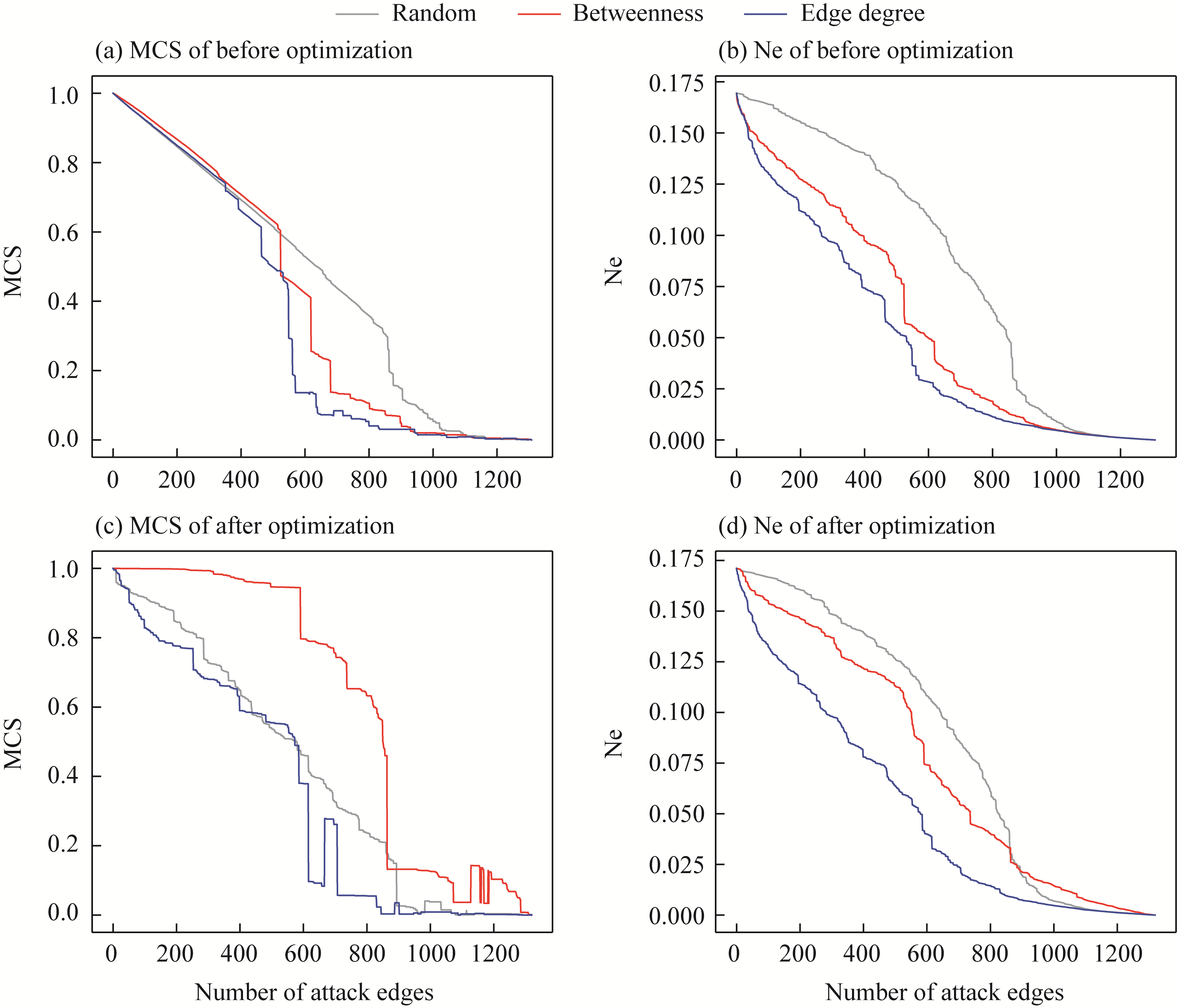
Abstract Increasing human disturbance and climate change have threatened ecological connectivity and structural stability, especially in semi-arid mountain areas with sparse vegetation and weak hydrological regulation. Large-scale ecological restoration, such as adding ecological sources or corridors, is difficult in such environments and often faces poor operability and high implementation costs in practice. Taking the southern slope of the Qilian Mountains in China as the study area and 2020 as the baseline, this study integrated weighted complex network theory into the "ecological source-resistance surface-corridor" framework to construct a heterogeneous ecological network (EN). Circuit theory was integrated with weighted betweenness to identify critical barrier points for locally differentiated restoration, followed by assessment of the network optimization effects. The results revealed that 494 ecological sources and 1308 ecological corridors were identified in the study area. Fifty-one barrier points with restoration potential were identified along key ecological corridors and locally restored. After optimization, the network gained 11 additional ecological corridors, and the total ecological corridor length increased by approximately 1143 km. Under simulated attacks, the decline rates of maximum connected subgraph (MCS) and network efficiency (Ne) slowed compared with pre-restoration conditions, indicating improved robustness. These findings demonstrate that targeted local restoration can enhance network connectivity and stability while minimizing disturbance to the overall landscape pattern, providing a practical pathway for ecological restoration and sustainable management in semi-arid mountain areas.
|
|
Received: 05 June 2025
Published: 30 November 2025
|
|
Corresponding Authors:
*PAN Hongyi (E-mail: panhongyi80@sicnu.edu.cn)
|
|
|
| [1] |
Albert R, Barabási A L. 2002. Statistical mechanics of complex networks. Reviews of Modern Physics, 74: 47, doi: 10.1103/RevModPhys.74.47.
|
|
|
| [2] |
Baggio J A, Salau K, Janssen M A, et al. 2011. Landscape connectivity and predator-prey population dynamics. Landscape Ecology, 26(1): 33-45.
doi: 10.1007/s10980-010-9493-y
|
|
|
| [3] |
Barrat A, Barthélemy M, Pastor-Satorras R, et al. 2004. The architecture of complex weighted networks. Proceedings of the National Academy of Sciences of the United States of America, 101(11): 3747-3752.
|
|
|
| [4] |
Beltrão M G, Gonçalves C F, Brancalion P H S, et al. 2024. Priority areas and implementation of ecological corridor through forest restoration to safeguard biodiversity. Scientific Reports, 14(1): 30837, doi: 10.1038/s41598-024-81483-y.
|
|
|
| [5] |
Bröhl T, Lehnertz K. 2019. Centrality-based identification of important edges in complex networks. Chaos: An Interdisciplinary Journal of Nonlinear Science, 29(3): 033115, doi: 10.1063/1.5081098.
|
|
|
| [6] |
Cao W J, Jia G X, Yang Q K, et al. 2024. Construction of ecological network and its temporal and spatial evolution characteristics: A case study of Ulanqab. Ecological Indicators, 166: 112344, doi: 10.1016/j.ecolind.2024.112344.
|
|
|
| [7] |
Chen F Y, Luo Q L, Zhu Z B. 2025a. Integrating static and dynamic analyses in a spatial management framework to enhance ecological networks connectivity in the context of rapid urbanization. Ecological Modelling, 501: 111022, doi: 10.1016/j.ecolmodel.2025.111022.
|
|
|
| [8] |
Chen J, Wang S S, Zou Y T. 2022. Construction of an ecological security pattern based on ecosystem sensitivity and the importance of ecological services: A case study of the Guanzhong Plain Urban Agglomeration, China. Ecological Indicators, 136: 108688, doi: 10.1016/j.ecolind.2022.108688.
|
|
|
| [9] |
Chen X Y, Zhu B C, Li T S, et al. 2025b. Ecological risk networks: A network structure model for simulating negative ecological linkages among ecologically sensitive areas. International Journal of Disaster Risk Reduction, 119: 105316, doi: 10.1016/j.ijdrr.2025.105316.
|
|
|
| [10] |
Costa A, Martín González A M, Guizien K, et al. 2019. Ecological networks: Pursuing the shortest path, however narrow and crooked. Scientific Reports, 9(1): 17826, doi: 10.1038/s41598-019-54206-x.
pmid: 31780703
|
|
|
| [11] |
Dong C, Yu H Y, Qian X L, et al. 2024. Enhancing ecological connectivity in the Qilian Mountains: Integrating GCA and optimized MST models for ecological corridor construction. Ecological Indicators, 166: 112525, doi: 10.1016/j.ecolind.2024.112525.
|
|
|
| [12] |
Du S, Xu D Z, Sun F Y, et al. 2024. Identification of key areas for territorial ecological restoration: Focusing on ecological security and restoration potential. Frontiers in Environmental Science, 12: 1463683, doi: 10.3389/fenvs.2024.1463683.
|
|
|
| [13] |
El-Kebir M, Klau G W. 2014. Solving the maximum-weight connected subgraph problem to optimality. arXiv preprint arXiv: 1409.5308, doi: 10.48550/arXiv.1409.5308.
|
|
|
| [14] |
Estrada E, Bodin Ö. 2008. Using network centrality measures to manage landscape connectivity. Ecological Applications, 18(7): 1810-1825.
pmid: 18839774
|
|
|
| [15] |
Fenu G, Pau P L. 2018. Connectivity analysis of ecological landscape networks by cut node ranking. Applied Network Science, 3(1): 22, doi: 10.1007/s41109-018-0085-0.
pmid: 30839764
|
|
|
| [16] |
Fu H X, Zhang T, Wang J G. 2024. Evaluating suitability of development and construction with of minimum cumulative resistance model for a mountain scenic area in Jinyun Xiandu, China. Ecological Engineering, 202: 107240, doi: 10.1016/j.ecoleng.2024.107240.
|
|
|
| [17] |
Fu J X, Cao G C, Guo W J. 2020. Land use change and its driving force on the southern slope of Qilian Mountains from 1980 to 2018. Chinese Journal of Applied Ecology, 31(8): 2699-2709. (in Chinese)
|
|
|
| [18] |
Gao C, Pan H Y, Wang M C, et al. 2023. Identifying priority areas for ecological conservation and restoration based on circuit theory and dynamic weighted complex network: A case study of the Sichuan Basin. Ecological Indicators, 155: 111064, doi: 10.1016/j.ecolind.2023.111064.
|
|
|
| [19] |
Gao C, Wang M C, Yuan M, et al. 2024a. Incorporating seasonality, predictability, and modularity into the optimization of biodiversity conservation for ecological networks. Journal of Environmental Management, 370: 122473, doi: 10.1016/j.jenvman.2024.122473.
|
|
|
| [20] |
Gao J, Gong J, Li Y, et al. 2024b. Ecological network assessment in dynamic landscapes: Multi-scenario simulation and conservation priority analysis. Land Use Policy, 139: 107059, doi: 10.1016/j.landusepol.2024.107059.
|
|
|
| [21] |
Gao X, Liang X Y, Guo Z Y, et al. 2024c. The analysis of ecological network characteristics of Baiyangdian Basin in China using the complex network theory. Ecological Indicators, 167: 112650, doi: 10.1016/j.ecolind.2024.112650.
|
|
|
| [22] |
Gilbert-Norton L, Wilson R, Stevens J R, et al. 2010. A meta-analytic review of corridor effectiveness. Conservation Biology, 24(3): 660-668.
doi: 10.1111/j.1523-1739.2010.01450.x
pmid: 20184653
|
|
|
| [23] |
Gong W F, Liu T D, Duan X Y, et al. 2022. Estimating the soil erosion response to land-use land-cover change using GIS-based RUSLE and remote sensing: A case study of Miyun Reservoir, North China. Water, 14(5): 742, doi: 10.3390/w14050742.
|
|
|
| [24] |
Gu T, Tong Y W, Wang S Y, et al. 2024. Identifying the priority areas for ecological protection considering ecological connectivity and ecosystem integrity: A case study of Xianyang City, China. Ecological Indicators, 163: 112102, doi: 10.1016/j.ecolind.2024.112102.
|
|
|
| [25] |
Guan J J, Hu J M, Li B N. 2024. How to restore ecological impacts from wind energy? An assessment of Zhongying Wind Farm through MSPA-MCR model and circuit theory. Ecological Indicators, 163: 112149, doi: 10.1016/j.ecolind.2024.112149.
|
|
|
| [26] |
Guo P F, Zhang F F, Wang H Y. 2022. The response of ecosystem service value to land use change in the middle and lower Yellow River: A case study of the Henan section. Ecological Indicators, 140: 109019, doi: 10.1016/j.ecolind.2022.109019.
|
|
|
| [27] |
Guo Z Y, Zhu C X, Fan X, et al. 2025. Analysis of ecological network evolution in an ecological restoration area with the MSPA-MCR model: A case study from Ningwu County, China. Ecological Indicators, 170: 113067, doi: 10.1016/j.ecolind.2024.113067.
|
|
|
| [28] |
Han P Y, Xiong H J, Hu H Z, et al. 2024. Integrating risk-conflict assessment for constructing and optimizing ecological security patterns of polder landscape in the urban-rural fringe. Ecological Indicators, 166: 112256, doi: 10.1016/j.ecolind.2024.112256.
|
|
|
| [29] |
He J, Wang N L, Chen A, et al. 2019. Glacier changes in the Qilian Mountains, Northwest China, between the 1960s and 2015. Water, 11(3): 623, doi: 10.3390/w11030623.
|
|
|
| [30] |
He Y M, Pan H Y, Wang R S, et al. 2023. Research on the cumulative effect of multiscale ecological compensation in river basins: A case study of the Minjiang River Basin, China. Ecological Indicators, 154: 110605, doi: 10.1016/j.ecolind.2023.110605.
|
|
|
| [31] |
Hong W Y, Liu Y K, Wang W X, et al. 2025. Optimization model for urban ecological network connectivity considering geospatial constraints. Geo-spatial Information Science, 28(4): 1866-1879.
doi: 10.1080/10095020.2024.2392704
|
|
|
| [32] |
Huang L Y, Wang J, Fang Y, et al. 2021. An integrated approach towards spatial identification of restored and conserved priority areas of ecological network for implementation planning in metropolitan region. Sustainable Cities and Society, 69: 102865, doi: 10.1016/j.scs.2021.102865.
|
|
|
| [33] |
Huang X Y, Xiu L N, Lu Z X, et al. 2025. Ecological networks construction and optimization in the Longdong Loess Plateau: The advantages of self-organizing map and complex networks. Ecological Indicators, 170: 113138, doi: 10.1016/j.ecolind.2025.113138.
|
|
|
| [34] |
Jiang H, Peng J, Zhao Y N, et al. 2022. Zoning for ecosystem restoration based on ecological network in mountainous region. Ecological Indicators, 142: 109138, doi: 10.1016/j.ecolind.2022.109138.
|
|
|
| [35] |
Jiang H, Peng J, Liu M L, et al. 2024a. Integrating patch stability and network connectivity to optimize ecological security pattern. Landscape Ecology, 39(3): 54, doi: 10.1007/s10980-024-01852-w.
|
|
|
| [36] |
Jiang J W, Cai J W, Peng R, et al. 2024b. Establishment and optimization of urban ecological network based on ecological regulation services aiming at stability and connectivity. Ecological Indicators, 165: 112217, doi: 10.1016/j.ecolind.2024.112217.
|
|
|
| [37] |
Kang J M, Li C L, Li M R, et al. 2022. Identifying priority areas for conservation in the lower Yellow River Basin from an ecological network perspective. Ecosystem Health and Sustainability, 8(1): 2105751, doi: 10.1080/20964129.2022.2105751.
|
|
|
| [38] |
Li D B, Clements C F, Shan I L G, et al. 2021. Corridor quality affects net movement, size of dispersers, and population growth in experimental microcosms. Oecologia, 195(2): 547-556.
doi: 10.1007/s00442-020-04834-2
pmid: 33423105
|
|
|
| [39] |
Li J C, Shan R, Yuan W H. 2023. Constructing the landscape ecological security pattern in the Dawen River Basin in China: A framework based on the circuit principle. International Journal of Environmental Research and Public Health, 20(6): 5181, doi: 10.3390/ijerph20065181.
|
|
|
| [40] |
Li P X, Cao H, Sun W, et al. 2022. Quantitative evaluation of the rebuilding costs of ecological corridors in a highly urbanized city: The perspective of land use adjustment. Ecological Indicators, 141: 109130, doi: 10.1016/j.ecolind.2022.109130.
|
|
|
| [41] |
Liang G F, Niu H B, Li Y. 2023. A multi-species approach for protected areas ecological network construction based on landscape connectivity. Global Ecology and Conservation, 46: e02569, doi: 10.1016/j.gecco.2023.e02569.
|
|
|
| [42] |
Liu J, Chen J J, Yang Y P, et al. 2023a. Construction and optimization of an ecological network in the Yellow River source region based on MSPA and MCR modelling. International Journal of Environmental Research and Public Health, 20(4): 3724, doi: 10.3390/ijerph20043724.
|
|
|
| [43] |
Liu X, Han Y, Li Y H, et al. 2024. Construction of ecological network in Daihai Basin based on ecological security pattern and ecological service accessibility. Ecological Frontiers, 44(6): 1224-1231.
doi: 10.1016/j.ecofro.2024.07.004
|
|
|
| [44] |
Liu X Y, Su Y, Li Z G, et al. 2023b. Constructing ecological security patterns based on ecosystem services trade-offs and ecological sensitivity: A case study of Shenzhen Metropolitan Area, China. Ecological Indicators, 154: 110626, doi: 10.1016/j.ecolind.2023.110626.
|
|
|
| [45] |
Lü L, Zhang S H, Zhu J, et al. 2022. Ecological restoration strategies for mountainous cities based on ecological security patterns and circuit theory: A case of central urban areas in Chongqing, China. International Journal of Environmental Research Public Health, 19(24): 16505, doi: 10.3390/ijerph192416505.
|
|
|
| [46] |
Lu Y C, Huang D, Tong Z M, et al. 2024. A conceptual framework for constructing and evaluating directed ecological networks: Evidence from Wuhan Metropolitan Area, China. Environmental Impact Assessment Review, 106: 107464, doi: 10.1016/j.eiar.2024.107464.
|
|
|
| [47] |
Luo J L, Zhu L, Fu H. 2024. Construction of wetland ecological network based on MSPA-conefor-MCR: A case study of Haikou City. Ecological Indicators, 166: 112329, doi: 10.1016/j.ecolind.2024.112329.
|
|
|
| [48] |
Luo Y H, Wu J S. 2021. Linking the minimum spanning tree and edge betweenness to understand arterial corridors in an ecological network. Landscape Ecology, 36(5): 1549-1565.
doi: 10.1007/s10980-021-01201-1
|
|
|
| [49] |
McRae B H, Hall S A, Beier P, et al. 2012. Where to restore ecological connectivity? Detecting barriers and quantifying restoration benefits. PLoS ONE, 7(12): e52604, doi: 10.1371/journal.pone.0052604.
|
|
|
| [50] |
Nie H R, Zhao Y, Zhu J, et al. 2024. Ecological security pattern construction in typical oasis area based on ant colony optimization: A case study in Yili River Valley, China. Ecological Indicators, 169: 112770, doi: 10.1016/j.ecolind.2024.112770.
|
|
|
| [51] |
Pan J H, Liang J, Zhao C C. 2023. Identification and optimization of ecological security pattern in arid inland basin based on ordered weighted average and ant colony algorithm: A case study of Shule River Basin, NW China. Ecological Indicators, 154: 110588, doi: 10.1016/j.ecolind.2023.110588.
|
|
|
| [52] |
Qi X T, Khu S T, Yu P, et al. 2025. Integrating machine learning with the minimum cumulative resistance model to assess the impact of urban land use on road waterlogging risk. Journal of Hydrology, 654: 132842, doi: 10.1016/j.jhydrol.2025.132842.
|
|
|
| [53] |
Qian D W, Du Y G, Li Q, et al. 2021. Alpine grassland management based on ecosystem service relationships on the southern slopes of the Qilian Mountains, China. Journal of Environmental Management, 288: 112447, doi: 10.1016/j.jenvman.2021.112447.
|
|
|
| [54] |
Qu C, Xu J, Li W, et al. 2025. Integrating circuit theory and network modeling to identify ecosystem carbon sequestration service flow networks. Ecological Informatics, 87: 103077, doi: 10.1016/j.ecoinf.2025.103077.
|
|
|
| [55] |
Shen J K, Wang J Y, Wu T Y, et al. 2024. Building landscape ecological network with multi-scenario connectivity based on network fault tolerance index and networking technology in graph theory. Ecological Indicators, 166: 112417, doi: 10.1016/j.ecolind.2024.112417.
|
|
|
| [56] |
Shen Z, Wu W, Chen S F, et al. 2022. A static and dynamic coupling approach for maintaining ecological networks connectivity in rapid urbanization contexts. Journal of Cleaner Production, 369: 133375, doi: 10.1016/j.jclepro.2022.133375.
|
|
|
| [57] |
Song S, Xu D, Hu S S, et al. 2021. Ecological network optimization in urban central district based on complex network theory: A case study with the urban central district of Harbin. International Journal of Environmental Research and Public Health, 18(4): 1427, doi: 10.3390/ijerph18041427.
|
|
|
| [58] |
Sui X R, Xu Q L, Tao H, et al. 2024. Vegetation dynamics and recovery potential in arid and semi-arid Northwest China. Plants, 13(23): 3412, doi: 10.3390/plants13233412.
|
|
|
| [59] |
Sun D L, Wu X Q, Wen H J, et al. 2024a. Ecological security pattern based on XGBoost-MCR model: A case study of the Three Gorges Reservoir Region. Journal of Cleaner Production, 470: 143252, doi: 10.1016/j.jclepro.2024.143252.
|
|
|
| [60] |
Sun W J, Yu Q, Xu C L, et al. 2024b. Construction and optimization of ecological spatial network in typical mining cities of the Yellow River Basin: The case study of Shenmu City, Shaanxi. Ecological Process, 13: 60, doi: 10.1186/s13717-024-00539-z.
|
|
|
| [61] |
Tong A, Zhou Y, Chen T, et al. 2025. Constructing an ecological spatial network optimization framework from the pattern-process-function perspective: A case study in Wuhan. Remote Sensing, 17(15): 2548, doi: 10.3390/rs17152548.
|
|
|
| [62] |
Wang Y, Yu Q, Avirmed B, et al. 2025a. The response of ecosystem services to ecological spatial network patterns in China's arid and semi-arid regions. Ecological Indicators, 172: 113300, doi: 10.1016/j.ecolind.2025.113300.
|
|
|
| [63] |
Wang Y J, Qu Z Y, Zhong Q C, et al. 2022a. Delimitation of ecological corridors in a highly urbanizing region based on circuit theory and MSPA. Ecological Indicators, 142: 109258, doi: 10.1016/j.ecolind.2022.109258.
|
|
|
| [64] |
Wang Z C, Zhao X S, Cui L J, et al. 2025b. Identification and optimization of urban wetland ecological networks in highly urbanized areas: A case study of Haidian District, Beijing. Ecological Indicators, 170: 113028, doi: 10.1016/j.ecolind.2024.113028.
|
|
|
| [65] |
Wang Z X, Xiao L, Yan H M, et al. 2022b. Optimization of the ecological network structure based on scenario simulation and trade-offs/synergies among ecosystem services in Nanping. Remote Sensing, 14(20): 5245, doi: 10.3390/rs14205245.
|
|
|
| [66] |
Wanghe K Y, Guo X L, Wang M, et al. 2020. Gravity model toolbox: An automated and open-source ArcGIS tool to build and prioritize ecological corridors in urban landscapes. Global Ecology and Conservation, 22: e01012, doi: 10.1016/j.gecco.2020.e01012.
|
|
|
| [67] |
Wei Q, Halike A, Yao K X, et al. 2022. Construction and optimization of ecological security pattern in Ebinur Lake Basin based on MSPA-MCR models. Ecological Indicators, 138: 108857, doi: 10.1016/j.ecolind.2022.108857.
|
|
|
| [68] |
Wei S R, Yu T, Ji P, et al. 2024. Analysis on ecological network pattern changes in the Pearl River Delta forest urban agglomeration from 2000 to 2020. Remote Sensing, 16(20): 3800, doi: 10.3390/rs16203800.
|
|
|
| [69] |
Wei W, Zhang Y L, Wei X X, et al. 2025. Construction and optimization of ecological security patterns based on ecosystem service function and ecosystem sensitivity in the important ecological functional area—A case study in the Yellow River Basin. Ecological Engineering, 215: 107609, doi: 10.1016/j.ecoleng.2025.107609.
|
|
|
| [70] |
Wei X T, Eboy O V, Cao G C, et al. 2023. Spatio-temporal variation of water conservation and its impact factors on the southern slope of Qilian Mountains. Regional Sustainability, 4(1): 54-67.
doi: 10.1016/j.regsus.2023.03.001
|
|
|
| [71] |
West S, Cairns R, Schultz L. 2016. What constitutes a successful biodiversity corridor? A Q-study in the cape floristic region, South Africa. Biological Conservation, 198: 183-192.
doi: 10.1016/j.biocon.2016.04.019
|
|
|
| [72] |
Wu Y H, Qin F C, Li L, et al. 2024. Construction and optimisation of watershed scale ecological network: A case study of Kuye River Basin. Frontiers in Environmental Science, 12: 1364568, doi: 10.3389/fenvs.2024.1364568.
|
|
|
| [73] |
Xiang Q, Yu H, Huang H, et al. 2024. Assessing the resilience of complex ecological spatial networks using a cascading failure model. Journal of Cleaner Production, 434: 140014, doi: 10.1016/j.jclepro.2023.140014.
|
|
|
| [74] |
Xu D M, Peng J, Dong J Q, et al. 2024. Expanding China's protected areas network to enhance resilience of climate connectivity. Science Bulletin, 69(14): 2273-2280.
doi: 10.1016/j.scib.2024.04.036
pmid: 38724302
|
|
|
| [75] |
Xu X L, Wang S Y, Rong W Z. 2023. Construction of ecological network in Suzhou based on the PLUS and MSPA models. Ecological Indicators, 154: 110740, doi: 10.1016/j.ecolind.2023.110740.
|
|
|
| [76] |
Yang L Z, Niu T, Yu Q, et al. 2022a. Relationship between topological structure and ecosystem services of forest grass ecospatial network in China. Remote Sensing, 14(19): 4700, doi: 10.3390/rs14194700.
|
|
|
| [77] |
Yang Y, Zhou Y R, Feng Z, et al. 2022b. Making the case for parks: Construction of an ecological network of urban parks based on birds. Land, 11(8): 1144, doi: 10.3390/land11081144.
|
|
|
| [78] |
Ye H, Yang Z P, Xu X L. 2020. Ecological corridors analysis based on MSPA and MCR model—A case study of the Tomur World Natural Heritage Region. Sustainability, 12(3): 959, doi: 10.3390/su12030959.
|
|
|
| [79] |
Yin F J, Chen H X, Huang F M, et al. 2025. Construction of a blue-green ecological network in the Luoyuan Bay Area in Southeast China via the identification of important habitats. Ocean & Coastal Management, 261: 107541, doi: 10.1016/j.ocecoaman.2025.107541.
|
|
|
| [80] |
Yu Q, Yue D P, Wang Y H, et al. 2018. Optimization of ecological node layout and stability analysis of ecological network in desert oasis: A typical case study of ecological fragile zone located at Dengkou County (Inner Mongolia). Ecological Indicators, 84: 304-318.
doi: 10.1016/j.ecolind.2017.09.002
|
|
|
| [81] |
Zhang Q H, Wang J B. 2024. Multi-functional coupling-based rural ecological pattern construction and network prioritization evaluation: A case study of Jiangning District, Nanjing. Ecological Indicators, 166: 112277, doi: 10.1016/j.ecolind.2024.112277.
|
|
|
| [82] |
Zhang Q S, Tang F P, Chen H H, et al. 2024a. Assessing landscape fragmentation and ecological connectivity to support regional spatial planning: A case study of Jiangsu Province, China. Ecological Indicators, 162: 112063, doi: 10.1016/j.ecolind.2024.112063.
|
|
|
| [83] |
Zhang Y, Hu W Y, Liu T, et al. 2024b. Integrating ecosystem integrity and ES supply-demand process to explore ecological connectivity in Wuhan metropolitan area, China. Ecological Indicators, 163: 112128, doi: 10.1016/j.ecolind.2024.112128.
|
|
|
| [84] |
Zhang Y, Cao G C, Zhao M L, et al. 2025. Integrated effects of climate, topography, and greenhouse gas on grassland phenology in the southern slope of the Qilian Mountains. Atmosphere, 16(6): 653, doi: 10.3390/atmos16060653.
|
|
|
| [85] |
Zhao C Y, Nan Z G, Cheng G D. 2005. Methods for modelling of temporal and spatial distribution of air temperature at landscape scale in the southern Qilian Mountains, China. Ecological Modelling, 189(1-2): 209-220.
doi: 10.1016/j.ecolmodel.2005.03.016
|
|
|
| [86] |
Zhao J K, Yu Q, Xu C L, et al. 2023. Integrated approach for ecological restoration and ecological spatial network optimization with multiple ecosystem functions in mining areas. Ecological Indicators, 156: 111141, doi: 10.1016/j.ecolind.2023.111141.
|
|
|
| [87] |
Zhao L S, Yu W Y, Meng P, et al. 2022. InVEST model analysis of the impacts of land use change on landscape pattern and habitat quality in the Xiaolangdi Reservoir Area of the Yellow River Basin, China. Land Degradation & Development, 33(15): 2870-2884.
doi: 10.1002/ldr.v33.15
|
|
|
| [88] |
Zou C, Tang X X, Tan Q, et al. 2024. Constructing ecological networks for mountainous urban areas based on morphological spatial pattern analysis and minimum cumulative resistance models: A case study of Yongtai County. Sustainability, 16(13): 5559, doi: 10.3390/su16135559.
|
|
|
|
Viewed |
|
|
|
Full text
|
|
|
|
|
Abstract
|
|
|
|
|
Cited |
|
|
|
|
| |
Shared |
|
|
|
|
| |
Discussed |
|
|
|
|